

CT Rain
-
Posts
26,272 -
Joined
-
Last visited
Content Type
Profiles
Blogs
Forums
American Weather
Media Demo
Store
Gallery
Everything posted by CT Rain
-

Monitoring a potential important TV to East Coastal storm: Jan 17
CT Rain replied to Typhoon Tip's topic in New England
The coastal flood threat on the Sound is pretty significant. The probabilistic ESTOFS has a median tide of 7.1ft MLLW at New London which is really high for them (highest since Sandy... and before that the last time about 7ft was Hurricane Carol). I'm in Truro for the storm so am pretty stoked to see the wind tomorrow morning at the ocean. -
Monitoring a potential important TV to East Coastal storm: Jan 17
CT Rain replied to Typhoon Tip's topic in New England
It's really an ISO issue since Eversource is out of the generation business. They are extremely worried about what will happen if we get a prolonged cold snap - we actually had a call with them earlier this week about it. -
Monitoring a potential important TV to East Coastal storm: Jan 17
CT Rain replied to Typhoon Tip's topic in New England
You getting excited to see your lush lawn by midday Monday? -
Monitoring a potential important TV to East Coastal storm: Jan 17
CT Rain replied to Typhoon Tip's topic in New England
Yeah agreed. Seems like a reasonable compromise attm. -
Monitoring a potential important TV to East Coastal storm: Jan 17
CT Rain replied to Typhoon Tip's topic in New England
Kevin's been texting with extreme displeasure with this map. -
Monitoring a potential important TV to East Coastal storm: Jan 17
CT Rain replied to Typhoon Tip's topic in New England
First call
-
Monitoring a potential important TV to East Coastal storm: Jan 17
CT Rain replied to Typhoon Tip's topic in New England
I would take heavy under on those Euro snow maps down this way. For example by 7z it's already up to 32F in Hartford and only about 0.1" of QPF has fallen at that point. With a rapid changeover you're going to have issues with the snow maps and how they're assigning ptype per 3-hour increment. -
Monitoring a potential important TV to East Coastal storm: Jan 17
CT Rain replied to Typhoon Tip's topic in New England
Yeah it looks very windy along the coast. Pretty impressive stuff. Should just miss high tide but it's close down here. -
Monitoring a potential important TV to East Coastal storm: Jan 17
CT Rain replied to Typhoon Tip's topic in New England
Probably overdone but starting a snowstorm with strong SE flow at 850mb is not great! -
Monitoring a potential important TV to East Coastal storm: Jan 17
CT Rain replied to Typhoon Tip's topic in New England
maybe kevin can begin as rain with mangled flakes? What a nightmare this storm is. Like Will said it's so close to a beautiful setup... a total waste. -
Monitoring a potential important TV to East Coastal storm: Jan 17
CT Rain replied to Typhoon Tip's topic in New England
Epicosity..png.fe5d429e6dfd68097fc004bc1df9be88.png)
-
Monitoring a potential important TV to East Coastal storm: Jan 17
CT Rain replied to Typhoon Tip's topic in New England
-
Monitoring a potential important TV to East Coastal storm: Jan 17
CT Rain replied to Typhoon Tip's topic in New England
Who said we wouldn't get snow? Seems pretty reasonably that many get a couple inches and it washes away. -
Monitoring a potential important TV to East Coastal storm: Jan 17
CT Rain replied to Typhoon Tip's topic in New England
I also noticed on the soundings that back this way almost all of the omega was very low... right where the warm advection was maximized (like 850-700mb). For a while even with heavy precip we dried out at like -8c and above. Even if you hold off the boundary layer torch by an hour or two... it wasn't exactly an encouraging sign. -
Monitoring a potential important TV to East Coastal storm: Jan 17
CT Rain replied to Typhoon Tip's topic in New England
I bet the weenies reacted with violence. I'll be in Truro for the weekend so I'm all for some damaging gusts Monday AM. -
Monitoring a potential important TV to East Coastal storm: Jan 17
CT Rain replied to Typhoon Tip's topic in New England
Imagine living in Connecticut and being excited for snow with a look like this.
.thumb.png.6237ea8235c4955202f22d2f1868e422.png)
-
Monitoring a potential important TV to East Coastal storm: Jan 17
CT Rain replied to Typhoon Tip's topic in New England
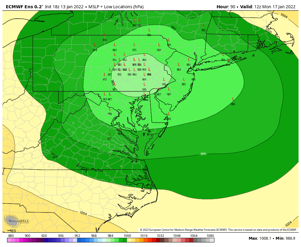
Probably too far west. Tough to get something over the Apps. Still, shows where the best upper level forcing is for the storm track. Well west. Going to be tough to get sig snows 6"+ south of 84/Pike -
Monitoring a potential important TV to East Coastal storm: Jan 17
CT Rain replied to Typhoon Tip's topic in New England
Looks like a tick west on the 18z Euro Ensembles.
-
Monitoring a potential important TV to East Coastal storm: Jan 17
CT Rain replied to Typhoon Tip's topic in New England
For sure. At least for my backyard seems like we're going to have a really hard time preventing the torch as the high retreats and wind cranks out of the E/SE. Farther north up toward the Pike I think there's definitely more room. -
Monitoring a potential important TV to East Coastal storm: Jan 17
CT Rain replied to Typhoon Tip's topic in New England
Euro is really warm in the boundary layer. 2m temps at BDL up to +4c at 12z Monday. -
Monitoring a potential important TV to East Coastal storm: Jan 17
CT Rain replied to Typhoon Tip's topic in New England
I'm not sure it makes a huge difference south of the Pike... but farther north if you do have a mesolow or some weakness offshore you might be able to hold some boundary layer chill a bit longer. -
Monitoring a potential important TV to East Coastal storm: Jan 17
CT Rain replied to Typhoon Tip's topic in New England
It's funny how everyone hated the offshore mesolows on the last storm... but is all about them this storm. -
Monitoring a potential important TV to East Coastal storm: Jan 17
CT Rain replied to Typhoon Tip's topic in New England
-
Monitoring a potential important TV to East Coastal storm: Jan 17
CT Rain replied to Typhoon Tip's topic in New England
The 3-hour increments with rapid boundary layer warming will make the model output for ptype fairly dubious. But yeah, a decent thump of snow before rain. -
Monitoring a potential important TV to East Coastal storm: Jan 17
CT Rain replied to Typhoon Tip's topic in New England
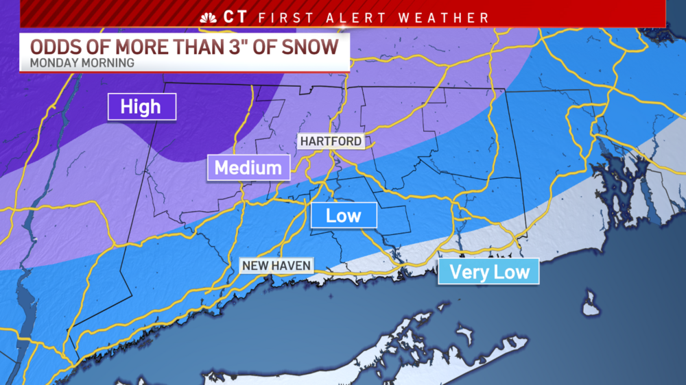
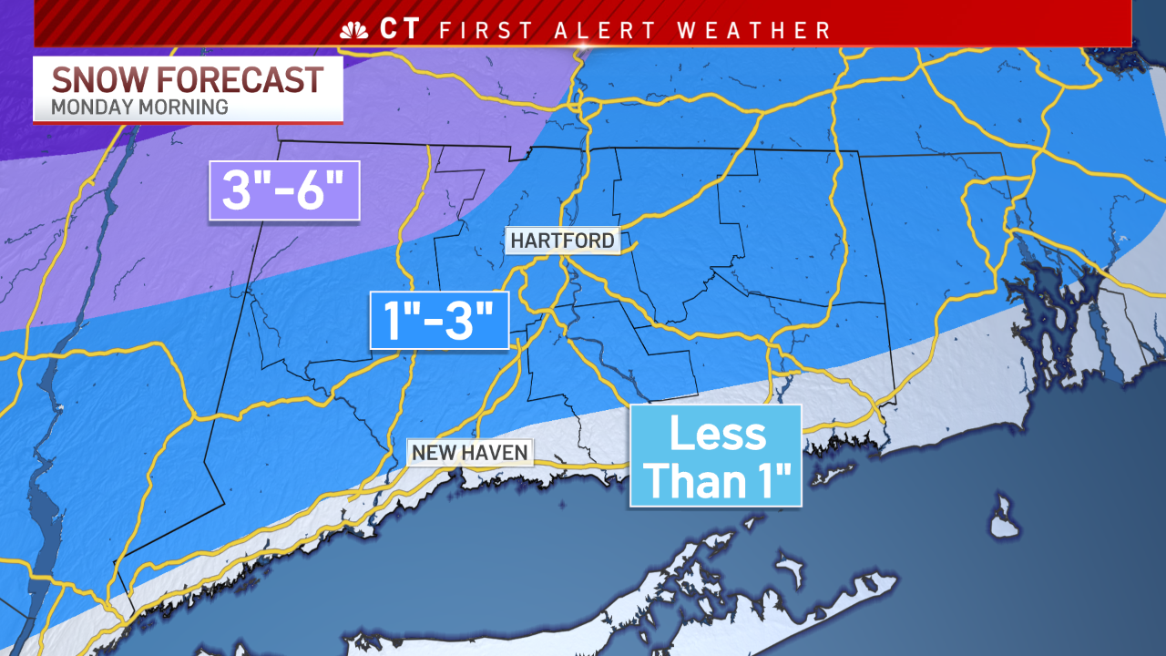
Barring a wholesale shift offshore... the retreating high and prolonged easterly flow is going to make it challenging to get >6" of snow south of the Pike. Even if you did track this thing over HVN-BOS for many it's heavy snow to heavy rain. I think a reasonable "best case scenario" for the I-84 corridor is like 3-6 or 4-8" followed by heavy rain. If the entire thing gets shunted offshore then we do better but that seems unlikely right now.


.png.d8ae83172bbb3c0d0b8c4ac0fad736a7.png)


