CT Rain
-
Posts
26,272 -
Joined
-
Last visited
Content Type
Profiles
Blogs
Forums
American Weather
Media Demo
Store
Gallery
Everything posted by CT Rain
-
 Loving the Euro. Let's do this.
 -
This also looks a lot better for E Mass/Boston than back this way so I think it's an easier call out that way.
-
I do think leading up to these storms the NWS/TV have a hard time sort of resetting when there's a trend toward a bust or more caution flags as the event nears. Ramping up is easy but no one wants to back down. After all the trends today this does not look like the same storm I was expecting when I went today... but you wouldn't know that from watching TV or reading that BOX AFD. I could definitely be wrong but there are far more caution flags right now than things that make me super stoked.
-
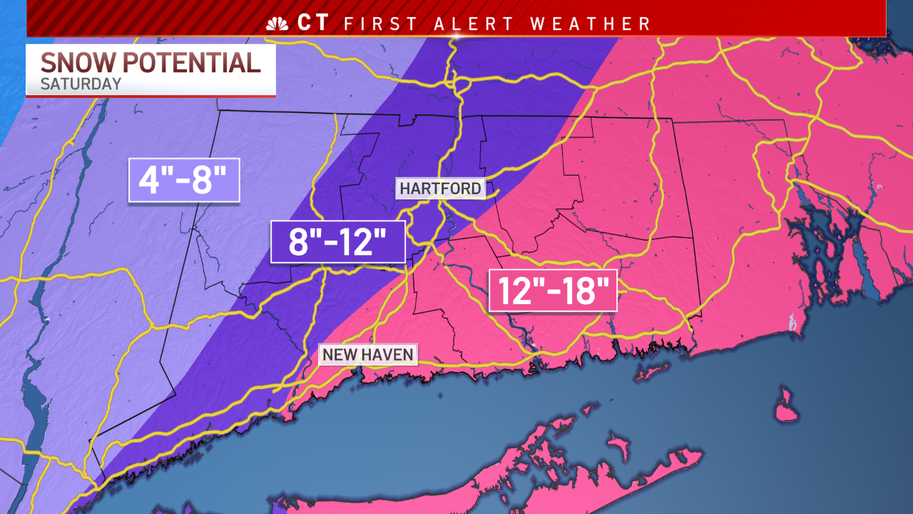
It is strange to see a lot of the TV people ramping up and the BOX AFD bordering on Armageddon. I don't really see it after the 12z runs and the data since - particularly in the Hartford area. Running with a 12-20" total was just too much for me given the guidance. Even getting more than a foot seems like a challenge at this point. I do like the look for S CT look for a nice burst overnight.
-
Yeah it's not like it's just the 3km NAM and the ARW chasing the convection offshore and everything else is big. The Euro, GFS, etc are trending toward trash.
-
I love the enthusiasm... but that BOX AFD seems completely divorced from the reality of every piece of guidance today.
-
Appreciate it. Seems like there's still quite a bit of uncertainty here.
-
Yeah I agree with this. The jet stream evolution just screams a crusher for most of SNE but that convection over the Gulf Stream wants to screw us. Seems like this is just going to wind up being a weird evolution overall.. and it has definitely sped up a lot.
-
That may or may not have been done on my second pass. bahahahahaha
-
Random thought this afternoon... but I think Long Island could be the jackpot here.
-
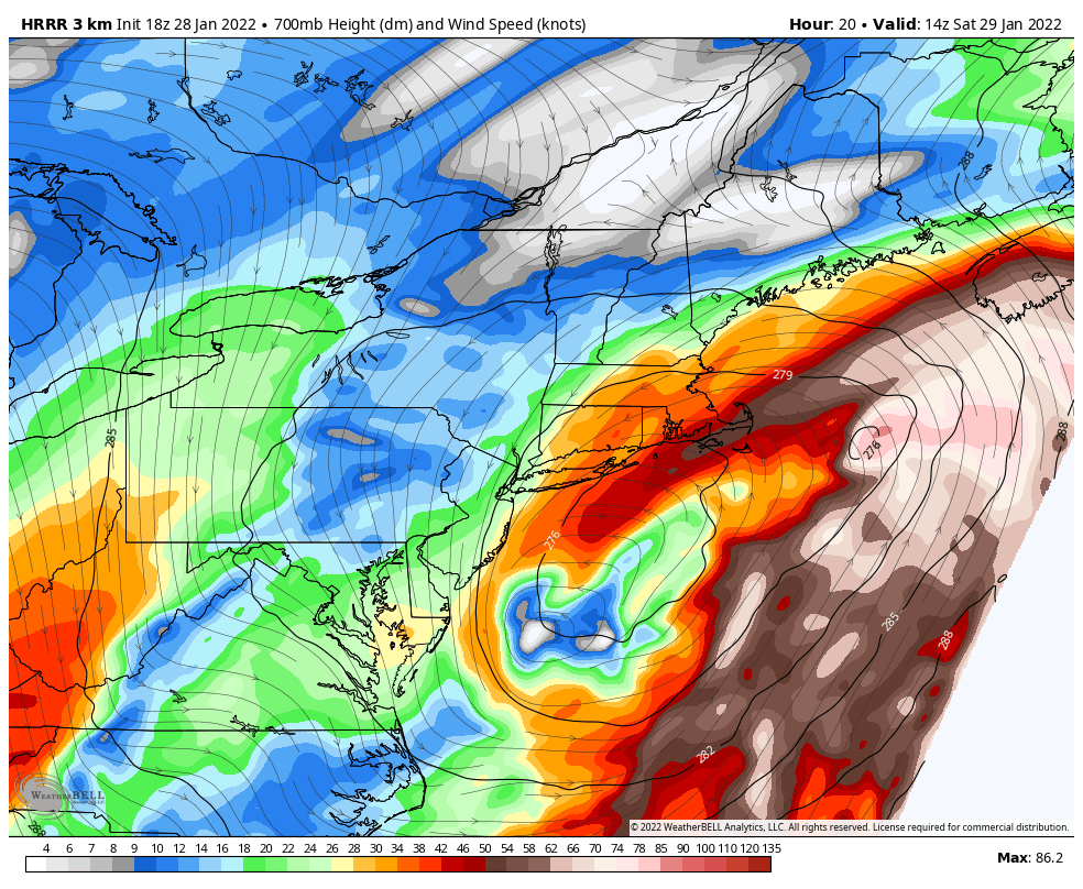
It's a super bizarre evolution. Like the HRRR has a nasty 500mb dry slot over Providence and Boston with the SLP center way outside of the benchmark. This one is going to look very very weird I think.
-
Yes - I actually feel better about the south coast. Seems like everything wants to close up and track a bit SE. I think LI and coastal CT could do very well.
-
Really bizarre to see the surface low waaaaay out of the benchmark and the 700mb low tucked so close to the coast. Not really sure what to make of it.

-
The 18z HRRR is so far southeast with these double barrel lows near the convection. It's a really really odd evolution.
-
I think I'm too high in the Hartford area. Hard to keep 12-20" when you have a pretty notable jump east with the mid level low centers especially.
-
Pretty sizable jump east on the EPS with with the low center and total QPF.
-
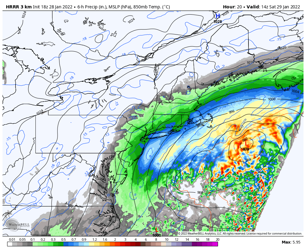
Yikes. What a nightmare. H7 low track looks ok early on back here but damn.
-
The omega thump on that band and even down toward Hartford is at like 400mb. Don't like that.
-
I agree with this. Still TBD. Also figuring out where the subby zone is just east of the big time deform snows.
-
Given that H7/H5 low track some mid level goodies back this way I think. Great run. See you all tomorrow.