

CT Rain
-
Posts
26,272 -
Joined
-
Last visited
Content Type
Profiles
Blogs
Forums
American Weather
Media Demo
Store
Gallery
Everything posted by CT Rain
-

March 2022 Obs/Disc: In Like a Lamb, Out Like a Butterfly
CT Rain replied to 40/70 Benchmark's topic in New England
I actually loved that event because we nailed the forecast. -
March 2022 Obs/Disc: In Like a Lamb, Out Like a Butterfly
CT Rain replied to 40/70 Benchmark's topic in New England
An event that will be studied for generations to come. -
Classless post. You should probably delete it.
-
Such awful news. My heart sank when I heard on Monday.
-
Remember when Ekster specifically called you out in the AFD about not getting an ice storm warning?
-
Some caution on Ginx's 4" of sleet and 5" of snow in Tolland. The 3km NAM actually shows very little accumulation through 0z Sunday if you look at positive snow depth change.
.png.60d6f2381b987ed1d3d8e2726130c870.png)
-
About 4" here in West Hartford. A beautiful, wet, sticky snow. The landscape looks great.
-
lol Wood divided by 2.
-
Close to 3". We probably picked up close to 2 of that in an hour or so.
-
2.5" here in West Hartford. Roads are a mess.
-
Looks like the NAM cut back a decent bit.
-
FWIW, 18z NAM is much colder at 2m than the 12z run was.
-
Yeah - you can actually see that fairly well on the 3km NAM with the boundary layer chilling quite a bit as the heavier rates come in around 18z. Interesting event for sure,.
-
Sure did. Still pretty borderline in the valley in the boundary layer... I think we struggle quite a bit outside of the hills.
-
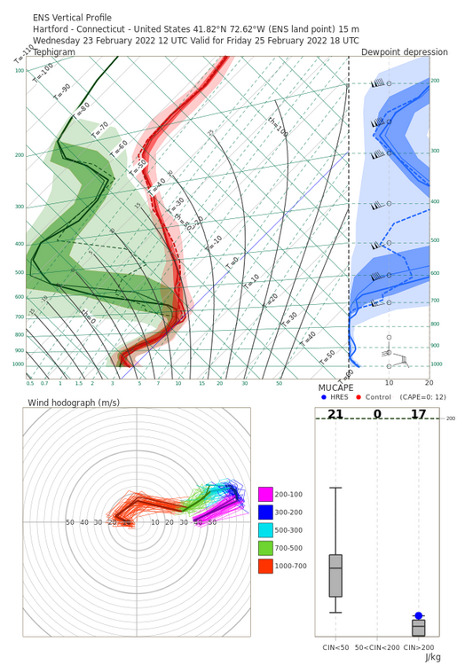
Winter storm for the 25th of February is imminent.
CT Rain replied to Typhoon Tip's topic in New England
Check out the 12z and 18z full res Euro ensemble soundings for Hartford. Definitely far colder than other models (and maybe freezing drizzle there at the end with dry mid levels)..thumb.png.d43c76d1ff5dc46d0704ef8fcbf1e976.png)
-
Winter storm for the 25th of February is imminent.
CT Rain replied to Typhoon Tip's topic in New England
GFS basically all snow for Hartford. -
Winter storm for the 25th of February is imminent.
CT Rain replied to Typhoon Tip's topic in New England
Synoptically this looks pretty good with that cold high to the north... not in retreat. -
The GFS is really insistent on some pesky dry air around 850mb underneath the good H7 fronto.
-
Wow - yeah. Didn't expect to see that.
-
Maybe - but there's not a ton of cold to the north of us right now. Springfield VT in the valley there is 33/30 and Keene NH is 37/37. Going to take some time. Not like we have a ton of cold just luring north of the Pike to advect in.
-
Yea I feel like the 12k/3k NAM are easy closing calls. Gets pretty cold pretty quickly.
-
FWIW for the ice lovers south of the Pike... the 00z NAM is quite a bit colder (and faster) than the 18z was.
-
There is a big push down the Hudson Valley. Albany is already 28/25 but it's quite a bit milder in S VT at a higher latitude. Even the global models have picked up on this... pretty impressive.
-
Tomorrow afternoon is looking sort of gnarly. NAM nest is upper 20s by 18z for N CT with an additional 0.25" of liquid between 18z and 00z. Seems like a pretty nasty glaze/pingers. A lot of the morning drive we may rot around 33F.
-
The cold push is looking less and less impressive around here tomorrow morning. Seems like we sort of rot at 32/33F for a while. Definitely not a flash freeze look.


.png.43433eb95eb45c426d0158d52091f87d.png)

