CT Rain
-
Posts
26,272 -
Joined
-
Last visited
Content Type
Profiles
Blogs
Forums
American Weather
Media Demo
Store
Gallery
Everything posted by CT Rain
-

Monitoring a potential important TV to East Coastal storm: Jan 17
CT Rain replied to Typhoon Tip's topic in New England
GFS is a horror show for the weenies. -
Monitoring a potential important TV to East Coastal storm: Jan 17
CT Rain replied to Typhoon Tip's topic in New England
-
Monitoring a potential important TV to East Coastal storm: Jan 17
CT Rain replied to Typhoon Tip's topic in New England
Yeah... looks like heavy snow to heavy rain right now. If the antecedent airmass sucked it would be brief snow to rain. -
Monitoring a potential important TV to East Coastal storm: Jan 17
CT Rain replied to Typhoon Tip's topic in New England
Yeah the antecedent airmass is pretty tasty. -
Monitoring a potential important TV to East Coastal storm: Jan 17
CT Rain replied to Typhoon Tip's topic in New England
It's a really cold antecedent airmass so even the GFS track is probably a decent burst of +SN before we pour. -
Monitoring a potential important TV to East Coastal storm: Jan 17
CT Rain replied to Typhoon Tip's topic in New England
Kevin is always excited for a damaging southeaster though. -
Monitoring a potential important TV to East Coastal storm: Jan 17
CT Rain replied to Typhoon Tip's topic in New England
We cut. -
Seems like this weekend is a bit of a stretch but man what a tasty pattern D10-D15.
-
7.5 in West Hartford melted to 0.50"
-
FWIW the HREF members are a bit juicier across SNE at 00z than they were at 12z.
-
Oh sorry, I was talking CT. Yeah... still time to get cranking in E Mass especially.
-
Seems like the convection is going to be an issue. A bit disappointing to see the RAP/HRRR and the NAM trends but still looks good for 3-6 in many spots in CT.
-
I was sort of hyping this afternoon. Definitely hedged high verbally after looking at those model soundings off the GFS/NAM. Hopefully the HRRR is off the mark.
-
I know. Not really comfortable ditching my 3-6 in Hartford... but a crush/fluff job under that mid level band wouldn't shock me.
-
Yes... that has me worried for the Hartford area. Could definitely see a 10" jack in that mid level banding given the MAUL and good snow growth.
-
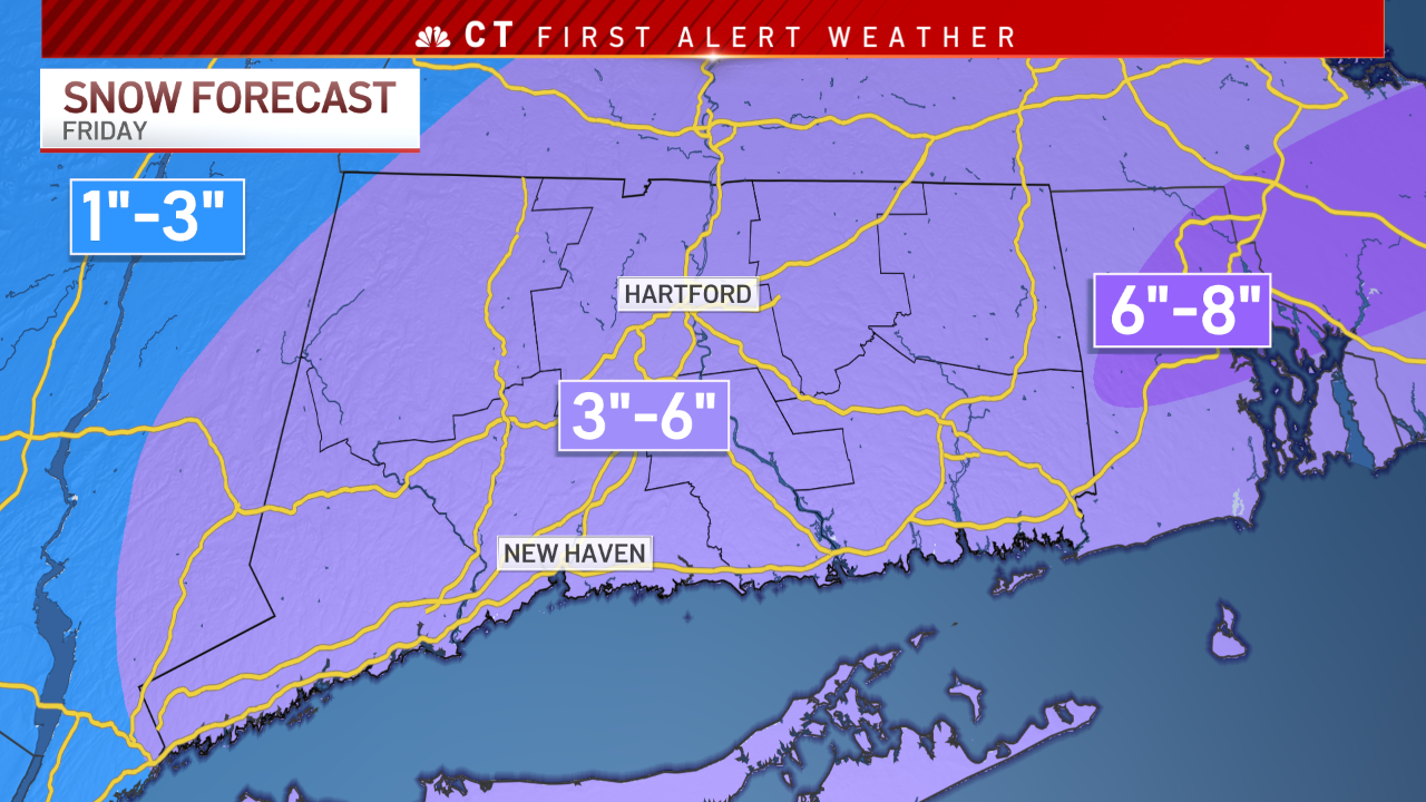
Updated numbers
-
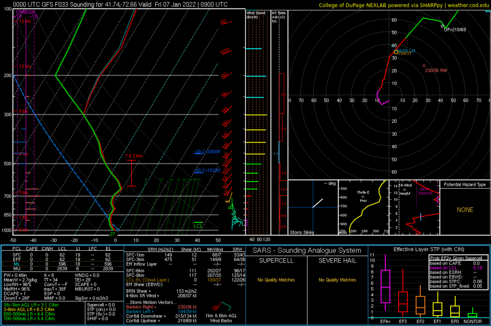
Yeah absolutely. What I meant by not a huge impact is you can't look at that SLP spread and think some members are whiffs and 200 miles off ACK and others are tucked in near BID. Definitely a dual low structure which makes those spread graphics a bit more difficult to interpret than a straight synoptic low track question. Given the amount of convection (with intense supercells) the HRRR is blowing up I think the dual low idea is definitely pretty reasonable right now.
-
This is definitely an odd look. Can certainly see the EPS struggling with chasing the convection. I actually think even with a really wide spread in those little Ls there's probably not nearly as much spread in the sensible wx impact here. Could certainly see competing lows and a more strung out kind of appearance but the super out to sea solutions are still going to have a weaker low closer to the coast and plenty of snow in SNE.
.thumb.png.f01f5eaeb12bcfed1be0512091ea8a2c.png)
-
The HRRR is ripping supercells over the Gulf Stream. Definitely the reason for the double low and generally unimpressive QPF. Totally disrupts to warm conveyorbelt processes. Meh.
.thumb.png.45f5ee5b85e70a4071bb0ca1a15b2831.png)
-
You can see the RAP closing the H7 low over Long Island Sound. Not a bad look.
.thumb.png.3f3830fd1b3fb5f7ebc5bfc785b1e533.png)
-
Wouldn't take much to do it with some nice frontogenesis and even a bit of a MAUL. Relatively deep DGZ. When someone gets 0.6" of liquid and 15:1 kinda rates...
-
Here's my new map.

-
Nice MAUL for Hartford on the GFS. We take.
-
The 3km NAM was run from Kevin's basement. Total I-84 weenie jack. Definitely looks like some mid level goodies pretty far NW.


.png.70abac8a377ec6a14cb9819bdbdf8602.png)
.png.cf44d569361f208cea4bf063ce3193c6.png)
.png.272a5f12b82adeee278e349cf129e16e.png)