

CT Rain
-
Posts
26,272 -
Joined
-
Last visited
Content Type
Profiles
Blogs
Forums
American Weather
Media Demo
Store
Gallery
Everything posted by CT Rain
-
 HRRR coming in hot too with a good bump NW from 18z. Nice start to the 00z suite.
 -
Pretty sizable jump NW on the EPS.
-
Euro is a great run for E Mass. Better back here but almost marginally. Also looks like the H7 low closes a bit earlier and tracks pretty close to the south coast. Definitely better.
-
How could I not?
-
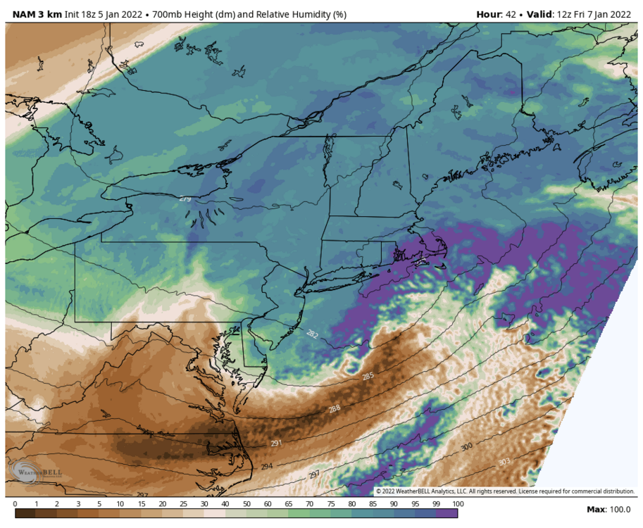
I don't hate that 700mb low track on the NAM. Explains the QPF max/mid level goodies from HFD to BOS.
-
There are a lot of nice EPS members to the west... but there are plenty pretty far south and east like what the NAM is showing. Seems like the NAM is well within the reasonable range of solutions.
-
I don't see nearly that much QPF
-
Looks like a great scooter sh*t streak
-
Wouldn't it be amazing if Kevin changed to rain after all?
-
Yeah a friend from high school in Essex texted me that they had hail bigger than pea size and it was really loud. I didn't believe him and made him take pictures. Then 15 minutes later he texted again to say it was pouring rain. Meanwhile... it was still snow in Montauk lol
-
Yeah - I think the biggest factor is that there was a tremendous amount of convection in that band so you had a lot of latent heat release doing some funky things to the thermal profile. When we had 1/4 mile +SN in Groton and reports of rain and hail on the east side of the mega band we knew something pretty wild was happening. The "asteroid ice" that fell was more like hail than sleet - plenty of riming and also some legit hail characteristics around the updrafts.
-
December 2021 Obs/Disco...Dreaming of a White-Weenie Xmas
CT Rain replied to 40/70 Benchmark's topic in New England
Quickly above freezing on Mount Tolland for a wet Christmas? -
December 2021 Obs/Disco...Dreaming of a White-Weenie Xmas
CT Rain replied to 40/70 Benchmark's topic in New England
Pretty strong model signal for the last day or two for a really icy start Christmas morning. -
December 2021 Obs/Disco...Dreaming of a White-Weenie Xmas
CT Rain replied to 40/70 Benchmark's topic in New England
Same on my car this morning! I took a picture too haha -
Even Hartford/Tolland may get a nice thump before pl/zr/ra. Maybe a 1-3 kinda deal for N CT and more north of the Pike?
-
December 2021 Obs/Disco...Dreaming of a White-Weenie Xmas
CT Rain replied to 40/70 Benchmark's topic in New England
Yeah was not expecting the EPS to looks so different. Very little signal for something on Monday. -
Did Kevin lock in 3-6?
-
Yeah we'll see. Hopefully we luck out a bit.
-
I'm getting to Vail on December 9. Just a nightmare pattern out there for the next 2 weeks.
-
Given the environment with those storms it was bizarre not to have a SVR in effect especially with those velocity signatures.... AND the large number of TDSs already on Long Island. Wasn't great but hopefully next time will be better.
-
It was tough. I wasn't in the office but we did go on a few times with updates. Not having even a SVR in effect (for some inexplicable reason) made the entire thing far more challenging to cover than it should have been.
-
How many would have been confirmed pre dual pol?
-
I think the old Modellab is done. They're shutting it down.
-
I managed to avoid getting in an accident while surveying lol
-
Crazy as always.


