

CT Rain
-
Posts
26,257 -
Joined
-
Last visited
Content Type
Profiles
Blogs
Forums
American Weather
Media Demo
Store
Gallery
Everything posted by CT Rain
-
Looks pretty good to me WOR. I think there's definitely a tornado threat W CT and Hudson Valley as wind fields increase later this afternoon and surface winds remain backed a bit.
-
There could definitely be a dud day or two next week if one of those shortwaves tracks underneath us.
-
-
Yeah I have partly/mostly cloudy and low 50s. Not great.
-
What a nightmare that is.
-

Saturday, March 26, 2022 Convective Grauple/Small Hail/gusty Showers
CT Rain replied to weatherwiz's topic in New England
Decent look for Saturday. Some hail/graupel plus a change to snow in the hills. GFS has TTs spiking to 64 around here which is about as high as you'll see... and the instability doesn't just peak for an hour and abate... it's there for a few hours. -
Saturday, March 26, 2022 Convective Grauple/Small Hail/gusty Showers
CT Rain replied to weatherwiz's topic in New England
Yeah... TTs spike above 60 for a time. Definitely has a squall look for the higher elevations. -
March 2022 Obs/Disc: In Like a Lamb, Out Like a Butterfly
CT Rain replied to 40/70 Benchmark's topic in New England
I had 10" of extremely heavy wet snow in Guilford at 250' ASL. Lots a tree and some big branches. Was quite a storm! -
March 2022 Obs/Disc: In Like a Lamb, Out Like a Butterfly
CT Rain replied to 40/70 Benchmark's topic in New England
Boxing Day was the worst. The firehose storm was annoying. -
March 2022 Obs/Disc: In Like a Lamb, Out Like a Butterfly
CT Rain replied to 40/70 Benchmark's topic in New England
I'm not sure I've ever been angry about not getting 5" of snow on March 23rd. -
March 2022 Obs/Disc: In Like a Lamb, Out Like a Butterfly
CT Rain replied to 40/70 Benchmark's topic in New England
I actually loved that event because we nailed the forecast. -
March 2022 Obs/Disc: In Like a Lamb, Out Like a Butterfly
CT Rain replied to 40/70 Benchmark's topic in New England
An event that will be studied for generations to come. -
Classless post. You should probably delete it.
-
Such awful news. My heart sank when I heard on Monday.
-
Remember when Ekster specifically called you out in the AFD about not getting an ice storm warning?
-
Some caution on Ginx's 4" of sleet and 5" of snow in Tolland. The 3km NAM actually shows very little accumulation through 0z Sunday if you look at positive snow depth change.
.png.60d6f2381b987ed1d3d8e2726130c870.png)
-
About 4" here in West Hartford. A beautiful, wet, sticky snow. The landscape looks great.
-
lol Wood divided by 2.
-
Close to 3". We probably picked up close to 2 of that in an hour or so.
-
2.5" here in West Hartford. Roads are a mess.
-
Looks like the NAM cut back a decent bit.
-
FWIW, 18z NAM is much colder at 2m than the 12z run was.
-
Yeah - you can actually see that fairly well on the 3km NAM with the boundary layer chilling quite a bit as the heavier rates come in around 18z. Interesting event for sure,.
-
Sure did. Still pretty borderline in the valley in the boundary layer... I think we struggle quite a bit outside of the hills.
-
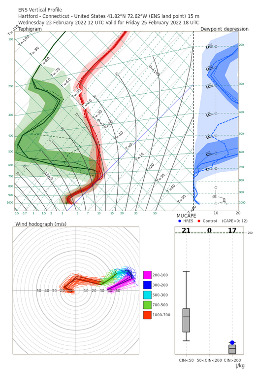
Winter storm for the 25th of February is imminent.
CT Rain replied to Typhoon Tip's topic in New England
Check out the 12z and 18z full res Euro ensemble soundings for Hartford. Definitely far colder than other models (and maybe freezing drizzle there at the end with dry mid levels)..thumb.png.d43c76d1ff5dc46d0704ef8fcbf1e976.png)


.png.43433eb95eb45c426d0158d52091f87d.png)
