

BlizzardNole
-
Posts
2,807 -
Joined
-
Last visited
Content Type
Profiles
Blogs
Forums
American Weather
Media Demo
Store
Gallery
Everything posted by BlizzardNole
-
I haven't been paying attention and didn't know the deep south has WSWs up. Memphis is looking at up to 6 inches of cold smoke with temps in the teens and low 20s. Damn
-
Darn no blizzard game now -- guess we settle for "Ice Bowl II" at Kansas City tonight. They found a window Monday afternoon where the snow stops then it snows again from later that night until......FRIDAY
-
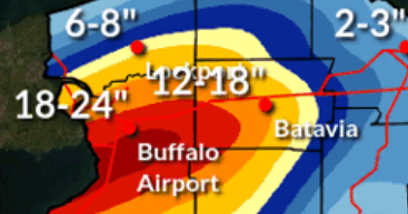
WOW I just looked at the Buffalo forecast and tomorrow's 1 pm game is going to be insane. I didn't know the stadium was south of the city which is in the better lake effect area. P&C has heavy snow with gusts to 45 during the day tomorrow with 16-28 inches total between tonight thru tomorrow night. Will they even play the game there?
-
Jan Medium/Long Range Disco 2: Total Obliteration is Coming
BlizzardNole replied to Jebman's topic in Mid Atlantic
I'd be happy with a 2019 type winter which had one good 10-12 inch storm and few smaller events for a total of around 25" for me -
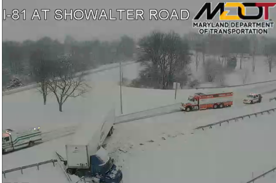
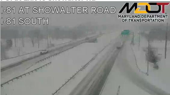
Just looked at that MD cam north of Hagerstown again and saw this. Ooof
-
Moderate rain and 33, oh well. I do believe we'll have an area wide nice hit at some point this winter Check out this spot near the Hagerstown Airport
-
The other day a national news show was talking about the small earthquake near Rockville and were calling it "southern Maryland" Still light snow in Germantown and a little coating on tables, etc
-
Some light snow in Germantown which surprises me. 34 degrees
-
They were saying on a news show that this year's calendar is a repeat of 1996 including being a leap year and it made me think back on how excited I was on January 5, 1996. We went to a house party the night of the 6th as it was getting going and had a fun drive back to my girlfriend's house (now wife). What a weekend and week of weather! I can't believe I have just about exactly doubled my age since then
-
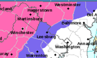
I wonder if there should be a NW/SE division for Frederick and Carroll Counties? (Sorry if there already are). There will be a big difference between say Urbana and Thurmont
-
I forgot about that Jan. 2022 storm! It nailed Calvert where some of my family lives, whereas here in Germantown my last big snow was 2019. I'm hoping for luck with Saturday's system. In 1978 (in central PG County) we had a system predicted to be brief period of snow then all rain. We got a surprise three hour thump that gave us 5-6 inches, then drizzle
-
My gosh look at that gradient over just the 23 miles between Damascus at the top of Mont Co and Silver Spring!
-
Saw a few flakes on my walk just now. Hoppy New Years everyone! (Not a typo - got some Torpedo IPA chilling in the fridge )
-
Jan Medium/Long Range Disco: Winter is coming
BlizzardNole replied to stormtracker's topic in Mid Atlantic
Ah 1979! I was in northern Calvert and it's my best ever - even beating all my MontCo events (1996, 2003, 2010 and 2016). It was like a hurricane of snow with easily 30 inches with 6-foot drifts. There was a period where we could not see the woods 50 feet behind the house and got 6" in one hour. Wind gusts 60-plus. I was there for 1983 - dry slot got us. Missed 1987 in FL. 1993 was a gut punch with 6" then driving rain -
Jan Medium/Long Range Disco: Winter is coming
BlizzardNole replied to stormtracker's topic in Mid Atlantic
THIS! I was a snow weenie in the late 70s/80s and all I had was TV weather folks and my Bearcat weather radio LOL. I can't say enough how much I appreciate the mets and forecasting experts on this board Whatever happens happens next weekend but I am confident that we will get a couple good events out of this winter -
2.2 near Germantown and having it fall over all those hours makes it a perfect soaker
-
Just noticed that the Miami Hurricanes are in Yankee Stadium for their bowl game against Rutgers on Dec. 28 -- can we get the coldest possible arctic airmass for that day please? Snow would be fantastic
-
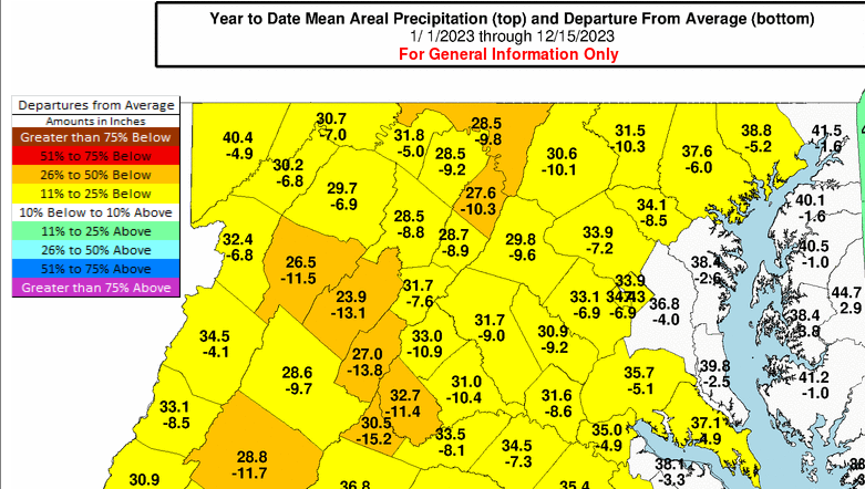
I know we all wish this was snow but I am pretty happy for the rainfall amounts from that last storm and now this one looking like a good 2-3" or more to put another dent in these departures. I feel like even without ideal set-ups, getting regular storms like this we are going to hit on one or two of them for some good snow
-
More important that any indices or teleconnections. We're good!
-
2018/19 was a nice winter with close to 30" total for me. Sign me up!
-
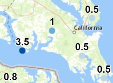
I was wondering about that too with much smaller amounts nearby, but maybe a lucky heavy burst? It's just curious though right on the water. Some good measurements in southern MD though, for example a couple inches in LaPlata (hi diatae!) Got 1.5 in Germantown which triples last winter's total MoCo schools delayed so my wife's preschool is closed. That's a gift since she's dealing with a bad cold and does not get paid on sick days
-
Yeah just a light rain event, never had more than brief moderate rain although the thunder this morning was nice. Rainfall east of the bay looks impressive
-
A number of years ago I drove to South Mountain Park in a similar setup and went from wet ground to 5" of snow and big cottonball flakes coming down. It was just 33 miles from my house. I was struck by how little snow was OTG close by near Frederick in the snow shadow Rain and 56
-
Thunder in Germantown! It's a treat for us because thunderstorms are so rare here in summer due to rain shadow -- I might get two or three over a whole season if I'm lucky
-
We had a nice snow shower at 10:20 am yesterday near Germantown. For a few seconds it was moderate snow


