BlizzardNole
-
Posts
2,949 -
Joined
-
Last visited
Content Type
Profiles
Blogs
Forums
American Weather
Media Demo
Store
Gallery
Everything posted by BlizzardNole
-
Another beautiful morning! I'll try to ignore those temps I just saw for next week
-
Cloudy, breezy and a cool 67. Base state!
-
1.3 on Saturday and 0.8 yesterday, 6.2 for the month. What a turnaround from earlier in the summer! Grass has greened back up but trees got hurt. There are yards where smaller trees have lost so many leaves that it looks like November. Even my big maples are dropping some already
-
Cell tracking to my south which is fine, then one little lobe blew up on the north side which barely scraped here. It was heavy, wind whipped sheets of rain with pea-sized hail. Man it makes me wonder what the heart of that sucker was like just to my east. I got 0.5 catching just the very edge of that. Anyone in Gaithersburg or Laytonsville? Adding: whew boy now another cell blowing up just behind that heading NE
-
Sun starting to break thru and a humid 77/71 Got the dreaded flash flood watch. Hope we didn't jinx it!
-
Looks like good rain chances again but we need this thick cloud deck to break some Low clouds, light drizzle and 72. Making me think of soup recipes
-
We were headed up 355 to visit friends and got caught in that very heavy cell and had to pull over north of Clarksburg. Some of those areas got 2" in about 20 minutes. I was very happy to find 1.3 in the gauge when we got home Hope everyone gets some tomorrow before the crisp fall weather arrives. And football!
-
Nice to be on the downswing of average highs -- now 87 and 84 by end of month (Dulles), then we get into gorgeous September. Except I'm afraid somewhere on the east coast is going to really get clocked by a hurricane that month. Hope not
-
Tropical Storm Debby: Mid-Atlantic Impacts
BlizzardNole replied to WxWatcher007's topic in Mid Atlantic
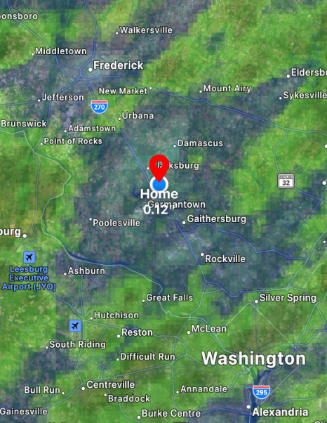
Thank you for that! It is dead-on for my spot (marked) and shows the much heavier amounts just to my east. This will be my go-to since they inexplicably ruined the iweather rainfall map which used to be really good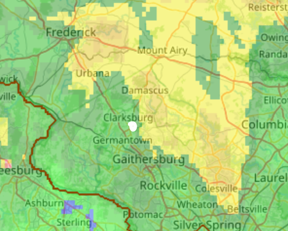
-
Tropical Storm Debby: Mid-Atlantic Impacts
BlizzardNole replied to WxWatcher007's topic in Mid Atlantic
I'd like to know too. iweather is OK and there's always cocorahs but I wish there was something more accurate and consistent -
Tropical Storm Debby: Mid-Atlantic Impacts
BlizzardNole replied to WxWatcher007's topic in Mid Atlantic
Looks like I'll end up with 3.0 for the event spread out over two days which is perfect. Now looking forward to some great weather starting tomorrow -
Tropical Storm Debby: Mid-Atlantic Impacts
BlizzardNole replied to WxWatcher007's topic in Mid Atlantic
Such a huge difference over short distances. I've seen some 4-5 inch amounts just east of me in central/east MoCo and they are under just a pain train of rain. I have 2.5 total which is perfect -
Tropical Storm Debby: Mid-Atlantic Impacts
BlizzardNole replied to WxWatcher007's topic in Mid Atlantic
Whoa you have just a firehose aimed at your area! I am just on the edge of it with off and on mod rain and I am fine with that -
Tropical Storm Debby: Mid-Atlantic Impacts
BlizzardNole replied to WxWatcher007's topic in Mid Atlantic
Rain comes down more intense than it looks on Radarscope. I got a shot of moderate rain under light greens. Makes me wonder what it's like under the yellows and oranges along the Howard/MoCo border -
Tropical Storm Debby: Mid-Atlantic Impacts
BlizzardNole replied to WxWatcher007's topic in Mid Atlantic
Finally scored with some intense bands this morning and have 1.5 in the gauge. That is amazing and is half of what we got in all of June and July combined. I love this kind of rain that is spread out and soaks in. The grass is already greening up I hope everyone gets the rain they need out of this! Oh and bonus just look at those gorgeous temps starting this weekend -
Tropical Storm Debby: Mid-Atlantic Impacts
BlizzardNole replied to WxWatcher007's topic in Mid Atlantic
Everything to my west tonight. I've lost -
Tropical Storm Debby: Mid-Atlantic Impacts
BlizzardNole replied to WxWatcher007's topic in Mid Atlantic
It has turned into another hot one with full sun and humidity. I hope those high temps from the weekend thru next week verify because they look great -
Picked up 0.52 which is most in a day since early July. I'm a little jealous of 1.0 to 1.8 inch amounts just 2-3 miles to my north and south but I have to take what I can get
-
Finally a nice hit from a thundershower. The first bolt was very close with the thunderclap less than a second after the flash. I love night lightning! Moderate rain for about 10 minutes. Hoping the stuff out west holds together
-
I am so looking forward to much lower temps over the coming days. This has been a rough summer! It would be extra sweet to get 2" of rain but that is asking a lot
-
Tropical Storm Debby: Mid-Atlantic Impacts
BlizzardNole replied to WxWatcher007's topic in Mid Atlantic
My area is in severe drought according to the map. The thing here is my specific spot (just NE of Germantown) misses close by over and over. Like Saturday I saw dark sky and thunder first to the N and later S with nothing here. Seems like south county gets the storms over and over or they swing up thru the high elevations to my west around to Damascus/Mt Airy. The big rain days a weeks ago yielded me 0.43 and I got just 1.1 for July. It would be incredible for my area to get 2 inches from this especially if it's spread out over a couple days. But man I have to see it first I am jaded -
Tropical Storm Debby: Mid-Atlantic Impacts
BlizzardNole replied to WxWatcher007's topic in Mid Atlantic
Sorry but have to see it to believe it. I'd be shocked and ecstatic to see more then a couple tenths -
I turned my garden sprinklers on early this morning and forgot to set a timer. Best rain in my garden all summer LOL! Two more blazing hot days to power thru and we get a big break on temps. I don't expect much rain but I'll take couple dry overcast and cool days
-
Congrats Gaithersburg again
-
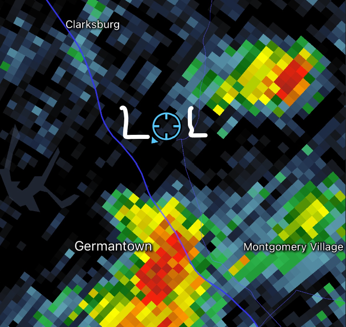
This pic tells the story of how things go here. It happens over and over and takes a fluke to get a summer t-storm here. My only chance is tropical remains in a few days but it wouldn't surprise me if there's a sharp cutoff to my east