RitualOfTheTrout
-
Posts
3,693 -
Joined
-
Last visited
Content Type
Profiles
Blogs
Forums
American Weather
Media Demo
Store
Gallery
Everything posted by RitualOfTheTrout
-

Pittsburgh/Western PA WINTER ‘25/‘26
RitualOfTheTrout replied to Burghblizz's topic in Upstate New York/Pennsylvania
Yeah it was a long shot. Still may see a few mangled flakes but nothing interesting. At least the morning commute won't be a disaster. I think we all knew at some point in December this would flip, that's Nina climo to some degree and patterns break down in general. Question is what happens afterwards into January. Shame we couldn't keep the cold around one more week and instead it gets gross just in time for Christmas. -
Pittsburgh/Western PA WINTER ‘25/‘26
RitualOfTheTrout replied to Burghblizz's topic in Upstate New York/Pennsylvania
Afternoon update from the NWS agrees. Tomorrow could be an interesting day if we manage to stay a few degrees cooler. Where the most tricky part of the forecast comes in is actually for the lower elevations of eastern OH and southwestern PA. 12z CAMs have taken on a slightly colder solution as the shield of precip arrives before sunrise and an enhanced push in the mid-morning hours. Forecast soundings show a very deep saturated layer well through and above the DGZ with strong synoptic forcing. Most of the entire profile is below freezing save the lowest few hundred feet where surface temperatures sit a degree or two above freezing. Should this be the case, a wet and cold rain will be the result. However, if surface temps are slightly overdone by the CAMs and/or dynamics cool the profile further than advertised, there is a conditional threat for a thump of heavy, wet snow to impact a good portion of southwest Pennsylvania, eastern Ohio, and the panhandle of West Virginia in the early morning to early afternoon hours. This may be a situation in which we have to see the whites of its eyes in the morning before knowing how it exactly will play out, but the worst case scenario could be a couple inches of accumulation with impacts to the morning commute. Finally, by the afternoon hours, a transition to convective snow showers with continued upslope in the ridges is likely as the stronger synoptic forcing moves east. Profiles suggest sufficient saturation through the DGZ remaining with steepening lapse rates in a low-level cold advection regime. Localized snow bands could produce another burst of accumulation and visibility reduction for the afternoon commute. Beyond the precipitation, tight surface gradients will foster gusty wind between 30-40 mph in the afternoon in the lower elevations, with 40-50 mph gusts possible in the ridges and peak gusts as high as 60 mph possible in the highest ridges of eastern Tucker County, WV. -
Pittsburgh/Western PA WINTER ‘25/‘26
RitualOfTheTrout replied to Burghblizz's topic in Upstate New York/Pennsylvania
Your probably right for the most part, but it was 11 degrees here this morning, then clouds moved in before any real sun could warm surfaces up. If we get a thump in the early morning hours, even if temps are marginal, it should have no problem accumulating especially on any subfreezing surfaces. Looks like more shots at some snow this weekend. Hopefully we can score a couple more events in the next 10 days, as it looks like the pattern is going to break down around Christmas. Who knows if it will actually happen that way or for how long, but ensembles are coming into agreement some sort of relaxation may be on the way. NWS seems to be biting onto this possibility as well. Confidence is increasing in a several day period where we have high temperatures some 15-20 degrees below average in the cP airmass through the weekend with highs in the 20s and lows in the teens or single digits. Cold air being entrenched across the region means any additional disturbances are likely to produce snow as the prevailing precip type areawide. While the overall pattern appears messy and ensembles are clearly struggling to agree on timing and intensity of any given wave, confidence is increase in at least one more shot at snowfall over the weekend before long term guidance finally has the eastern Canadian longwave trough breaking down. Stay tuned for more details as we get closer and confidence increases. -
Pittsburgh/Western PA WINTER ‘25/‘26
RitualOfTheTrout replied to Burghblizz's topic in Upstate New York/Pennsylvania
Measured a good 3, probably end with around 3.25ish, that last band sorta dissipated before it really moved through. Looks like areas just the NW managed a little better based on radar and reports. All in all this one played out exactly as expected based on models and NWS forecast. A+ -
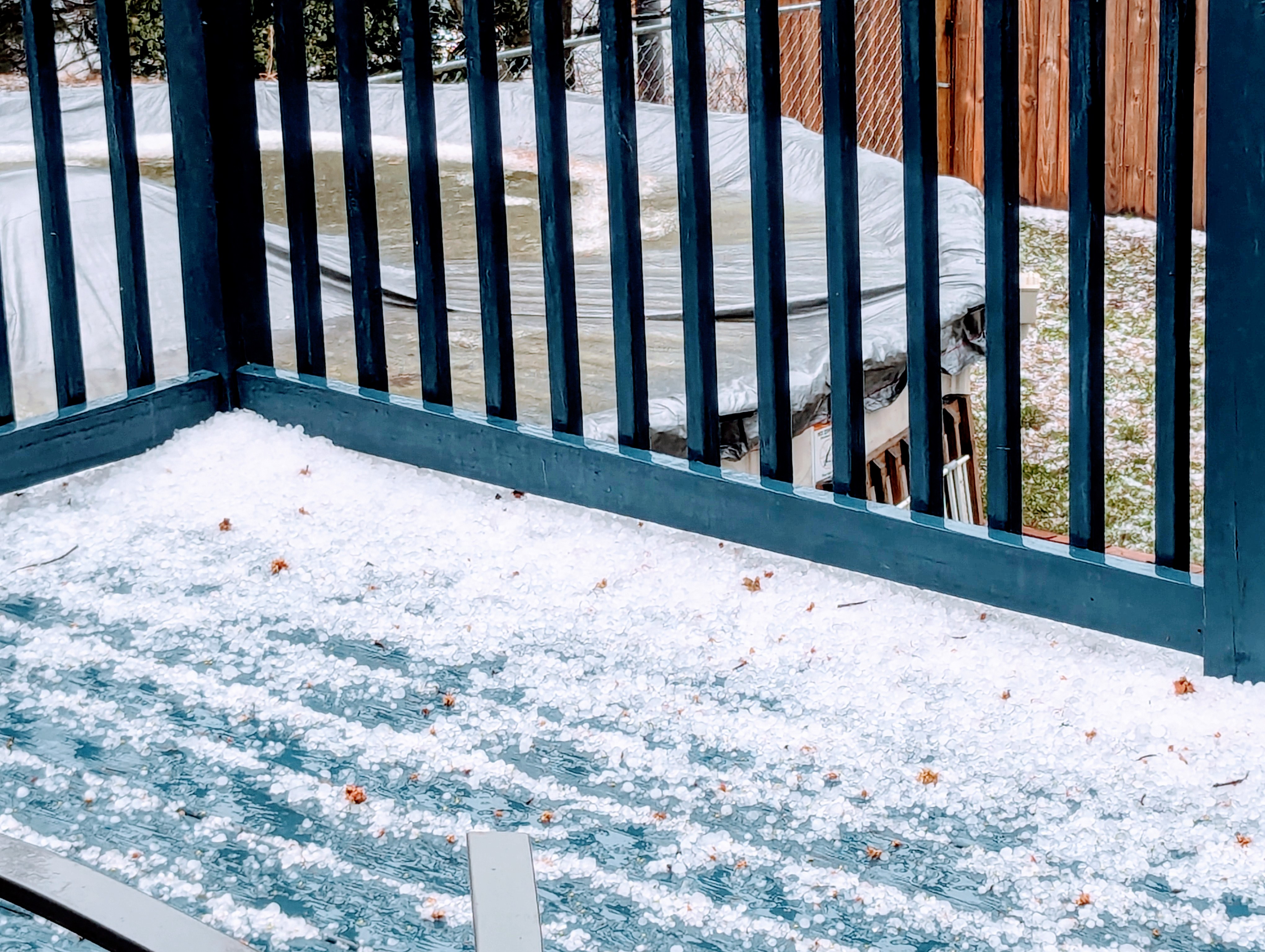
Pittsburgh/Western PA WINTER ‘25/‘26
RitualOfTheTrout replied to Burghblizz's topic in Upstate New York/Pennsylvania
Eyeballing 2-3 on the deck rail. Coming down at a moderate rate at the moment. -
Pittsburgh/Western PA WINTER ‘25/‘26
RitualOfTheTrout replied to Burghblizz's topic in Upstate New York/Pennsylvania
Things still on track. Surfaces should be plenty cold and very early morning timing will maximize accumulations. Im still thinking 2-4, with maybe a 5 lollipop if somewhere manages to maxmize ratios and banding, but overall progressive nature is going to limit that potential. Will be fun to kick off the season! -
Pittsburgh/Western PA WINTER ‘25/‘26
RitualOfTheTrout replied to Burghblizz's topic in Upstate New York/Pennsylvania
I'm here for some clippers, get them to dive underneath us then reinforce NW flow behind them over the warm lakes and you are looking at almost daily shots of snow. -
Pittsburgh PA Fall 2025 Thread
RitualOfTheTrout replied to TheClimateChanger's topic in Upstate New York/Pennsylvania
Looks like we are honing in on a 2-4 type deal. Not bad for early December if it plays out that way We lost our oldest dog in early November this year, playing in the snow made him so happy. No doubt taking the other 2 out to play will be bitter sweet for the first real accumulating event. -
Pittsburgh PA Fall 2025 Thread
RitualOfTheTrout replied to TheClimateChanger's topic in Upstate New York/Pennsylvania
I feel like I've been asleep at the wheel, just getting caught up on the upcoming threats. It was nice to have a cold / snowy Thanksgiving. Looking forward to tracking with everyone this season. -
I had one of those! I had it strapped around the handle bar on my bike to make sure I was home on time for periodic check-ins. That thing sat out in rain and many bike wrecks and took a licking and kept on ticking! lol Completely forgot about the thermometer part!
-
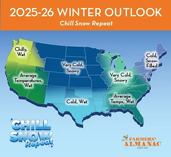
Enjoying the summer so far, it's been a great season for the pool this year. Warm water just about all summer (thanks to all the 90s). Pretty decent lightening show on the way to work this morning. Summer is cruising along. The older I get the less I look forward to the end of summer and fall and the start of Winter and he Holiday routine but don't worry I'll be in top form by November . This Farmers Almanac outlook would be sweet if it verified (probably as likely as the 384 GFS)
-
Pretty detailed write-up here: 40 Years Later: The May 31 1985 Tornado Outbreak I was living in Sarver, PA where the one F3 lifted at the time, pretty young but have some vague memories of that event. Probably a contributing factor to why Im on a weatherboard today. Also probably why this was my favorite book as a kid.
.jpeg.03778eca39fd8a1418e91065de024a74.jpeg)
-
Looking at the radar, feels like a winter storm, watching the heavy returns creep NE. Your not wrong. Sunday looks nice, then we should get a taste of summer.
-
Wild ride in this morning through Allegheny County, roads closed, miles and miles of neighborhoods without power, no traffic lights / street lights. Debris everywhere. Some places looked like war torn hell-scapes.
-
Yeah, maybe plateaued right around Allegheny line, still 72mph gust nothing to sneeze at. Tree down in the little wood strip in my backyard too.
-
Hey appreciate the Met post. I see you are in OK, did you used to live around here or just following the severe outbreak?
-
Power was out about 5 minutes here, back on for now. It was pretty erie for about 5 minutes before it hit, power was flickering while it was still sunny.
-
Looks like it, barring some last minute weakening its right in the bullseye. Hope I can get dinner off the grill in time!
-
Just making my way through the comments now, lots of reports / pictures of some pretty crazy stuff out of New Kensington. At least I know I wasn't seeing things lol.
-
Not going to complain about missing a tornado. Lol Still not sure what we saw. The clouds were moving so fast on approach so maybe it was an illusion of perspective or something, but it sure looked like a very broad area of rotation high up in the approaching cloud deck. Won't forget this one for awhile!
-
That cell that just went through here just got warned for tornado... Not suprised. My son and I were watching the cloud deck approach and I swear it looked like we could see the clouds rotating, or almost moving perpendicular to the storm morion, then all hell broke lose. May have just dodged a bullet.
.gif.5c23b980f5ece0af1190a3ca4a0cde6b.gif)
-
Thats a negative.. about 60 seconds of insane wind and hail, complete white out. That was intense. I thought the windows were going to get blown out. We don't typically get hit straight on like that.

-
Odd cloud movement with these storms. In-between two bands, getting some light rain now. May be enough to take some of the bite out of the main line, but time will tell.
-
Pittsburgh/Western PA Winter 2024-2025 Thread
RitualOfTheTrout replied to Rd9108's topic in Upstate New York/Pennsylvania
Most of sliding just to south of me, still had a enough to get a coating. Looks like some pretty good returns in western Allegheny. -
Pittsburgh/Western PA Winter 2024-2025 Thread
RitualOfTheTrout replied to Rd9108's topic in Upstate New York/Pennsylvania
Coating on the grass here with light to moderate wind driven snow.