RitualOfTheTrout
-
Posts
3,693 -
Joined
-
Last visited
Content Type
Profiles
Blogs
Forums
American Weather
Media Demo
Store
Gallery
Everything posted by RitualOfTheTrout
-

Pittsburgh/Western PA WINTER ‘25/‘26
RitualOfTheTrout replied to Burghblizz's topic in Upstate New York/Pennsylvania
NWS still seems bullish on the chance of heavier convective snow showers. Hopefully they are right. SNOW SQUALLS/SNOW SHOWERS ARE EXPECTED THIS MORNING INTO THIS AFTERNOON... Scattered snow showers are beginning to move through eastern Ohio late this morning. Some snow squalls are possible heading into this afternoon along and north of I-70. The most intense snow squalls are expected to be between 1pm and 6pm. Some challenging travel conditions will be possible with a sudden drop in visibility and a quick coating of snow within snow showers. If traveling remain alert for changing road conditions. $$ -
Pittsburgh/Western PA WINTER ‘25/‘26
RitualOfTheTrout replied to Burghblizz's topic in Upstate New York/Pennsylvania
I ended up with about an inch, maybe it was closer to 1.5 before the compacting / melting. -
Pittsburgh/Western PA WINTER ‘25/‘26
RitualOfTheTrout replied to Burghblizz's topic in Upstate New York/Pennsylvania
There it is! -
Pittsburgh/Western PA WINTER ‘25/‘26
RitualOfTheTrout replied to Burghblizz's topic in Upstate New York/Pennsylvania
Yes! I think that was North Pgh with the detour sign. -
Pittsburgh/Western PA WINTER ‘25/‘26
RitualOfTheTrout replied to Burghblizz's topic in Upstate New York/Pennsylvania
I don't mind all the little clippers, but I'd love to get some juiced up southern wave attack a cold dome of arctic air. -
Pittsburgh/Western PA WINTER ‘25/‘26
RitualOfTheTrout replied to Burghblizz's topic in Upstate New York/Pennsylvania
Yeah, its a haul, 28 miles each way 40-60 minutes each way. Fortunately I only have to do it 3 times a week between 4 x 10s and working from home. -
Pittsburgh/Western PA WINTER ‘25/‘26
RitualOfTheTrout replied to Burghblizz's topic in Upstate New York/Pennsylvania
Dang, that's crazy! You're making out good! Can't beat heavy snow with temps in the teens! It's been pretty quiet here at work in the West Mifflin area for the most part. There is definitely a nice band in western central Allegheny County right now. -
Pittsburgh/Western PA WINTER ‘25/‘26
RitualOfTheTrout replied to Burghblizz's topic in Upstate New York/Pennsylvania
It's fairly intuitive but go to my attachments in the dropdown under your username in the top right, then you can sort by size, and it shows you the thread it is posted in, so you can decide if it's like 2 years ago if it's worth keeping it. -
Pittsburgh/Western PA WINTER ‘25/‘26
RitualOfTheTrout replied to Burghblizz's topic in Upstate New York/Pennsylvania
I ended up with between a half and 1 inch when I left this morning, although a heavier band looked poised to swing through as I was leaving, so I'd hedge closer to 1in. From what I saw on the drive in that was pretty uniform, nowhere looked to have really gotten a lot more than any other. Looks like the winds are shifting more WNW, so it will be interesting to see if any narrow bands setup today. -
Pittsburgh/Western PA WINTER ‘25/‘26
RitualOfTheTrout replied to Burghblizz's topic in Upstate New York/Pennsylvania
You might be running low on storage, space. If you are doing the free version of the forum I think you get a max of 50mb. You might have to go back and delete stuff from older threads. A couple years ago I started doing the gold subscription for $25 a year, figured I should contribute something for the amount of time I spend on here plus I wanted the convenience of the extra storage space. I think you get a total of 200mb of storage for attachments with gold. But I have run into the same issue, if you are low on space your max upload size per post is whatever space you have left. Alternatively, you could do as climate changer said is host elsewhere and link in your post. -
Pittsburgh/Western PA WINTER ‘25/‘26
RitualOfTheTrout replied to Burghblizz's topic in Upstate New York/Pennsylvania
Just putting this here for posterity.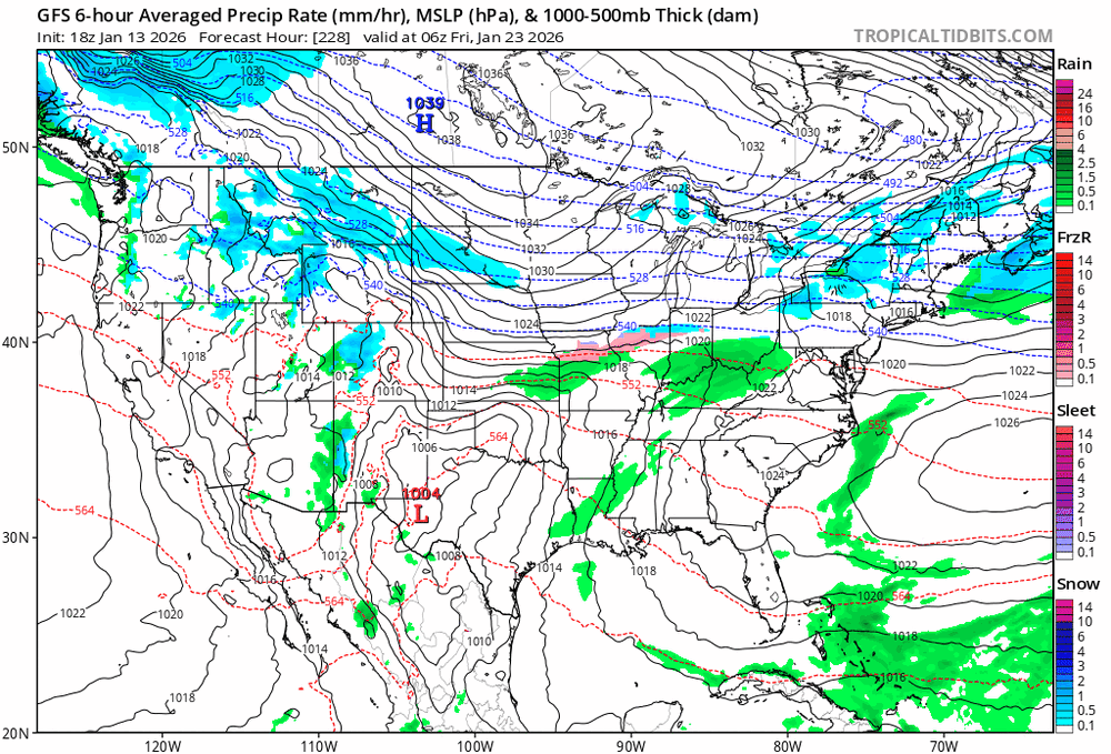
-
Pittsburgh/Western PA WINTER ‘25/‘26
RitualOfTheTrout replied to Burghblizz's topic in Upstate New York/Pennsylvania
I've never witnessed a map like that outside of some lake effect in the Tug, and certainly never for SWPA. Like 50 inches of that falls in 24 hours. Dear God lol. That's a fantasy run if I ever saw one. The region would be crippled for weeks. Might never see a snow map like that again, need to save that one. -
Pittsburgh/Western PA WINTER ‘25/‘26
RitualOfTheTrout replied to Burghblizz's topic in Upstate New York/Pennsylvania
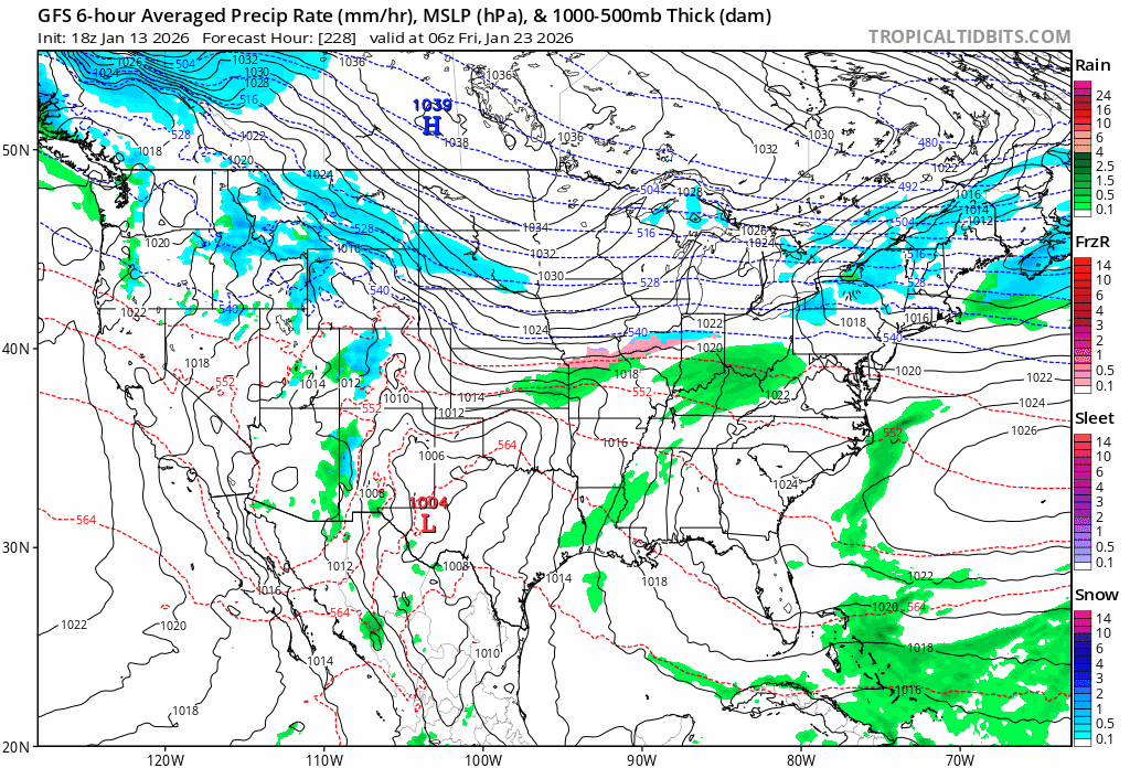
It looks active wednesday-sunday with various short waves rotating through. It will all be short range / nowcast type stuff but could be fun and we've done well this season thus far with that. -
Pittsburgh/Western PA WINTER ‘25/‘26
RitualOfTheTrout replied to Burghblizz's topic in Upstate New York/Pennsylvania
Looks like I might catch the southern tip of that line. Its about to blow through now. Edit: Brief shot at some moderate snow, put down a quick dusting. Looked like it was weakening as it crossed the area. Onto the mid week thing, I have no idea what to expect. NWS leaves the door open for us to see some snow out of it: A warmup is expected early in the week in SW flow ahead of an approaching deepening trough. The rain is expected to mix with and change to snow later Wednesday into Thursday as an associated cold front crosses the region. Snow chances could continue through late Thursday and Thursday night as the trough further deepens, and a surface wave possibly develops along the front. Plenty of uncertainty still exists in the development of this system, and trends will be monitored. -
Pittsburgh/Western PA WINTER ‘25/‘26
RitualOfTheTrout replied to Burghblizz's topic in Upstate New York/Pennsylvania
Im here for it, if its going to be above 50 in January it might as well push 70. Im at 65, here, opened up the windows for some fresh air. -
Pittsburgh/Western PA WINTER ‘25/‘26
RitualOfTheTrout replied to Burghblizz's topic in Upstate New York/Pennsylvania
Took the outdoor Christmas decorations down yesterday. It was nice, everything was dry and could go straight into storage rather than into the garage to dry for two weeks. Going forward we have the possible squalls Sunday colonel mentioned, then towards mid month all models agree there are a couple windows for a storm to come together. If I had to say, the pattern probably favors areas east of us, but a lot will depend on the orientation of the ridge out west and if / when any northern stream pieces phase and how far SW the trough digs. -
Pittsburgh/Western PA WINTER ‘25/‘26
RitualOfTheTrout replied to Burghblizz's topic in Upstate New York/Pennsylvania
Once it became clear the models whiffed on that stout west based -NAO setting up for the first week of Jan the thaw was all but a certainty and we would have a quiet period. As you said, we are now getting through the warm-up and starting to see hints into next week we may have a discrete threat to track soon. -
Pittsburgh/Western PA WINTER ‘25/‘26
RitualOfTheTrout replied to Burghblizz's topic in Upstate New York/Pennsylvania
Gorgeous deep winter night out there. Just came in from a walk and secondary shoveling. Fresh coating with light snow falling and temperature in the teens, light wind. Just trying to take it all in. -
Pittsburgh/Western PA WINTER ‘25/‘26
RitualOfTheTrout replied to Burghblizz's topic in Upstate New York/Pennsylvania
Most of my memories are from situations like this, usually in a squall line or strong arctic front. Honestly its probably not super rare for our region as a whole in this type of setup. Now getting it as part of a noreaster I can't recall the last time that happened. If I hadn't been outside I would have probably missed it. I'm not sure if there are any official statistics on it or not. -
Pittsburgh/Western PA WINTER ‘25/‘26
RitualOfTheTrout replied to Burghblizz's topic in Upstate New York/Pennsylvania
Wait til that second batch gets to you. Heavy snow, huge dendrites, its a thing of beauty. Phone camera can't do it justice. -
Pittsburgh/Western PA WINTER ‘25/‘26
RitualOfTheTrout replied to Burghblizz's topic in Upstate New York/Pennsylvania
Looks like one more moderate burst before the dry air starts to shut off the heavier snow. Its ripping here again. Gotta go back outside!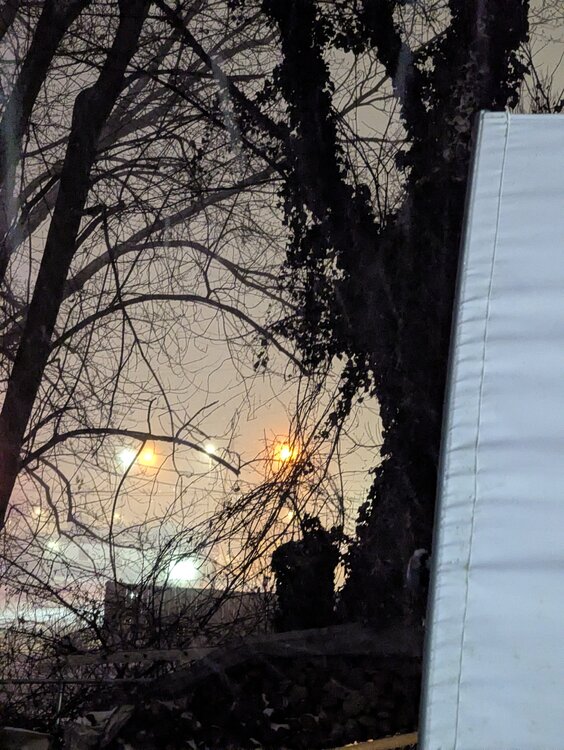
-
Pittsburgh/Western PA WINTER ‘25/‘26
RitualOfTheTrout replied to Burghblizz's topic in Upstate New York/Pennsylvania
Hard to say, its still ripping behind the main line. Id say .5 -.75 in the heart of it. It started out more graupel like, so I knew there was some convective element and a shot at thunder / lightening coupled with the 35dbz returns. I was pushing 4 inches before it hit, will probably get close to 5 for the event. -
Pittsburgh/Western PA WINTER ‘25/‘26
RitualOfTheTrout replied to Burghblizz's topic in Upstate New York/Pennsylvania
Just had thundersnow in the squall! Big flash of lightning! (Im outside shoveling) -
Pittsburgh/Western PA WINTER ‘25/‘26
RitualOfTheTrout replied to Burghblizz's topic in Upstate New York/Pennsylvania
Radar looks to be filling in, getting moderate snow here. Probably closing in on an inch and forecast was 3-5 so I think its still on track. It does look like areas that got more from the snow bands to the SW of the city are missing some of the better rates at the moment though. -
Pittsburgh/Western PA WINTER ‘25/‘26
RitualOfTheTrout replied to Burghblizz's topic in Upstate New York/Pennsylvania
Light to moderate snow here. Did start with some light freezing drizzle.