

RitualOfTheTrout
-
Posts
3,690 -
Joined
-
Last visited
Content Type
Profiles
Blogs
Forums
American Weather
Media Demo
Store
Gallery
Everything posted by RitualOfTheTrout
-

Pittsburgh/Western PA Winter 2024-2025 Thread
RitualOfTheTrout replied to Rd9108's topic in Upstate New York/Pennsylvania
I guess it depends how far South lol. Seems unlikely anything more than half inch or so for the city, but yeah further SE could get into the 1-2 inch range. Going to take a relatively large change given it's only 24 hours away for anyone NW of the city to see much I think. Either way whatever falls is just a "stats padder" as the next system Wednesday looks to be mostly rain right now. -
Pittsburgh/Western PA Winter 2024-2025 Thread
RitualOfTheTrout replied to Rd9108's topic in Upstate New York/Pennsylvania
Getting some light snow / flurries this morning. Wasn't expecting that. 12z 3k NAM bumped the precip shield a hair north for tomorrow. Not much, but maybe we could eek 1-2 out of it if it bleeds north up to game time. Im not expecting much of anything though. -
Pittsburgh/Western PA Winter 2024-2025 Thread
RitualOfTheTrout replied to Rd9108's topic in Upstate New York/Pennsylvania
Who knows, maybe we get a surprise and the 700mb frontgen band goes 200 miles further north and gets us Tuesday lol I wouldn't write anything off yet, but we need some changes for the next two after. Not out of the question one or both ends less amped and further south. This season thats been the trend. If it happens and its enough to make a difference here remains to be seen. -
Pittsburgh/Western PA Winter 2024-2025 Thread
RitualOfTheTrout replied to Rd9108's topic in Upstate New York/Pennsylvania
Pretty much a non event imby. All plain rain, no thunder. -
Pittsburgh/Western PA Winter 2024-2025 Thread
RitualOfTheTrout replied to Rd9108's topic in Upstate New York/Pennsylvania
Oh I agree 100%. I was using it to show the week after next might actually be more favorable if the pattern evolves as depicted. Realistically I think even expecting half that much is a stretch. -
Pittsburgh/Western PA Winter 2024-2025 Thread
RitualOfTheTrout replied to Rd9108's topic in Upstate New York/Pennsylvania
I guess the good part is it looks like after next week is when the better pattern takes hold so if it doesn't work out there's still opportunities to be had. 18z GFS had two big storms actually hit us and a couple little ones pushing 30+ inches.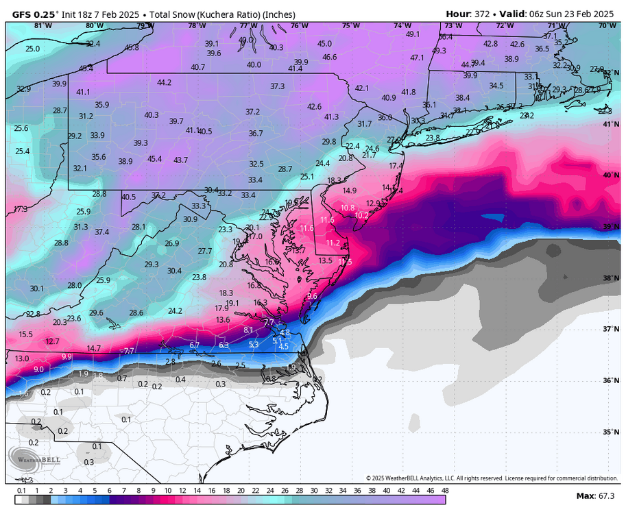
-
Pittsburgh/Western PA Winter 2024-2025 Thread
RitualOfTheTrout replied to Rd9108's topic in Upstate New York/Pennsylvania
Not a fan of the way things seem to be heading, weaker wave early next week that may whiff to the south then the follow-up is stronger and to far NW vs previously the first wave was a stronger and held less energy back for the second. Obviously nothing is carved in stone, but not a great look either atm. -
Pittsburgh/Western PA Winter 2024-2025 Thread
RitualOfTheTrout replied to Rd9108's topic in Upstate New York/Pennsylvania
Definitely heard some thunder around 2:45-ish last night. Overall, the the SW corner of the state the ice was not a big deal as we expected. Probably pretty dicey earlier in the night, but zero issues driving in at 4:30am. As I hear people talking filtering into the office I keep hearing "What happened to the big ice storm?" lol Where do people hear this stuff? Even the evening news was pretty subdued in terms of impacts. Looks like a repeat Saturday evening? Beyond that, next week we won't know how the boundary sets up until much closer. Update NY / NE looks to get hammered with multiple systems which may not bode well for us being on the right side of things. -
Pittsburgh/Western PA Winter 2024-2025 Thread
RitualOfTheTrout replied to Rd9108's topic in Upstate New York/Pennsylvania
Haha, Awesome. WeatherStar 4000+ Emulator? -
Pittsburgh/Western PA Winter 2024-2025 Thread
RitualOfTheTrout replied to Rd9108's topic in Upstate New York/Pennsylvania
Maybe something to keep an eye on for more of an impact, especially if we stay below freezing all day: Dry weather and cloudy skies continue through the rest of this afternoon. Light northeast winds and dense cloud cover are resulting in temperatures trending several degrees below what was originally progged in model guidance. Will need to keep an eye on this as it could impact the extent of ice accumulation late this evening and overnight as low pressure approaches and rain overspreads the area from the south and west. -
Pittsburgh/Western PA Winter 2024-2025 Thread
RitualOfTheTrout replied to Rd9108's topic in Upstate New York/Pennsylvania
Storm middle of next week looks promising at this range. Actually could use a more northern track but these next two look more wet than frozen for sure. -
Pittsburgh/Western PA Winter 2024-2025 Thread
RitualOfTheTrout replied to Rd9108's topic in Upstate New York/Pennsylvania
It only takes a light glaze for big problems, but I agree it should be pretty short lived. -
Pittsburgh/Western PA Winter 2024-2025 Thread
RitualOfTheTrout replied to Rd9108's topic in Upstate New York/Pennsylvania
Pretty crazy agreement. I would add some caution as several the individual ens members show warm nose scenarios too for the various storms. Not trying to be a downer, but I would expect some snow to mix to rain setups while areas not to far north or east get all or mostly snow. Just mentally prepare for that. If the setup is anywhere near to correct though I feel good we finally get a 5+ storm at least and maybe more if we can get an all or mostly all snow event. -
Pittsburgh/Western PA Winter 2024-2025 Thread
RitualOfTheTrout replied to Rd9108's topic in Upstate New York/Pennsylvania
I find a lover of all things winter weather, the occasional warm day is much more enjoyable especially when a change back to snow threats is on the horizon. It was nice to get outside and take a walk. Now, I'll be good if I don't see anymore days like that until the end of March. -
Pittsburgh/Western PA Winter 2024-2025 Thread
RitualOfTheTrout replied to Rd9108's topic in Upstate New York/Pennsylvania
So far so good on the pattern progression into the second week of Feb. If it holds there should be some trackable threats in a few days. -AO, -NAO, -EPO, and maybe even the PV splitting with a piece getting stuck over hudson bay. If its all correct I could see another 4 week plus window. Adjust for seasonal wavelengths shortening and more warmth south adding fuel to storm development and I like our chances to go out with a bang. -
Pittsburgh/Western PA Winter 2024-2025 Thread
RitualOfTheTrout replied to Rd9108's topic in Upstate New York/Pennsylvania
I've been keeping an eye on the MJO forecasts, and its definitely been verifying at a little higher amplitude than what was forecast a few days prior. Now it looks to (albeit still relatively quickly and weakly) traverse through phases 5-6-7, its not a surprise that the upcoming "warm" period looks a little more hostile in terms of the SER and storm tracks being a bit further North. Still not a no hope setup for snow, but given we won't be building any kind of snow pack, I'll certainly have less interest in little 1-2 inch possibilities. I still think mix events will be more likely than all snow and temperatures will be much more variable, but not straying super far from normal in any given day. Hopefully we get one more reload for the last 2 weeks of Feb into March, that still seems likely but as we know nothing is a guarantee in this hobby. -
Pittsburgh/Western PA Winter 2024-2025 Thread
RitualOfTheTrout replied to Rd9108's topic in Upstate New York/Pennsylvania
Light snow falling, pretty sure a trace was observed yesterday, so the streak continues! -
Pittsburgh/Western PA Winter 2024-2025 Thread
RitualOfTheTrout replied to Rd9108's topic in Upstate New York/Pennsylvania
The pattern is relaxing, I'd expect temperatures to fluctuate but not deviate to far from normal one way or the other after this weekend. Only little shots at snow over the next 7, less than inch type deals. The next bigger storm threat window looking like its associated with that cutoff low in the SW US over California and when it ejects out and how, ie does it come out all in one piece, or multiple little ones. GFS and Euro at 00z show it starting to move next week and possibly affect our area by next weekend (Feb 1 - 2) but of course this is all subject to change every 6 hours. The NAO and AO are positive so there isn't any blocking to hold cold air in place so its going to need to be well timed with a northern stream vort re-enforcing the cold or a decent high funneling cold in. This setup is more likely to result in a mixed precipitation type event (slop storm as we call them) as there is a pretty narrow path to all snow given all the things that would need to go right. After the last couple weeks of really maximizing a pretty dry pattern I wouldn't mind a mixed event if its more frozen than wet but we also don't have to stress over a couple tenths of qpf being the max upside.
-
Pittsburgh/Western PA Winter 2024-2025 Thread
RitualOfTheTrout replied to Rd9108's topic in Upstate New York/Pennsylvania
Blowing through here now, definitely more impressive than radar indicated. Less than a quarter inch, but went out during the height of it for a brisk but short walk. Love it! -
Pittsburgh/Western PA Winter 2024-2025 Thread
RitualOfTheTrout replied to Rd9108's topic in Upstate New York/Pennsylvania
Deep Winter out there.. It's been a great January. Mixed feeling about the pattern finally relaxing, on one hand wouldn't mind if this kept up, but also wouldn't mind seeing if we can get something more favorable for a bigger storm even if its more variable and less favorable for snow retention.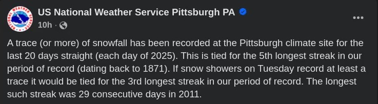
-
Pittsburgh/Western PA Winter 2024-2025 Thread
RitualOfTheTrout replied to Rd9108's topic in Upstate New York/Pennsylvania
Still looking like some possible impacts tomorrow. NWS thinking less than an inch, but with temperatures this cold a brief burst of heavy snow will deteriorate roads pretty quickly especially later afternoon / early evening. Along with cold weather, a potential shortwave is expected to cross the region Tuesday afternoon and increase the threat of hazardous travel due to snow. Snowfall amounts are expected to stay below Advisory criteria (likely 0.5 to 1.0 inches in isolated areas; a trace to 0.5 elsewhere). However, brief periods of low visibility from heavy snow can`t be ruled out. The 0-3km CAPE values range from 25J/kg to 50J/kg along the trough axis. Hi-Res guidance also has some noted potential stronger bands (reflectivity on the radar could measure 20DBZ to 30DBZ at times) between 3pm to 6pm (including Pittsburgh). If models remain consistent with this potential outcome, short- fused special weather statements and/or snow squall warnings may be needed to highlight the threat. -
Pittsburgh/Western PA Winter 2024-2025 Thread
RitualOfTheTrout replied to Rd9108's topic in Upstate New York/Pennsylvania
Well this didn't age well, may have missed that specific band, but made up for it between 11pm last night and now. When I left the house at 4:45 I had 2 fresh inches since 11pm and that heavier band was about to pivot through which I ended up driving through, heavy snow and 12 degrees, cars sliding all over on 28 pretty crazy, then when I got to the city clear as a bell until I hit another band. Late save by the lakes on this one. Looks like flow is rapidly shifting westerly so the fetches will get cutoff shortly but the arctic air will be spilling in. Wondering if this may be our last bout of LES assist as this incoming airmass should finish icing Erie over and start building up quickly on the others. -
Pittsburgh/Western PA Winter 2024-2025 Thread
RitualOfTheTrout replied to Rd9108's topic in Upstate New York/Pennsylvania
Getting some intermittent light to occasionally moderate bursts as what's left of that band finally made it. Much higher ratio / better flake structure than any point today. Should add another half inch or so. Too bad the arctic front is coming through at 3am, could be fun, although Ill be up for work at 430, roads will probably be dicey. The current 00Z sounding alludes the the heavily anticipated arctic frontal passing overnight tonight, with a tropopause of 500mb with dry stratospheric air above that. An adiabatic, nearly saturated layer is observed from the surface to roughly 800mb, which has been responsible for the convective snow during the early overnight hours tonight. The forcing for snow has mostly been the stark surface convergence as the cold air bullies is way in along the front. The frontal passage will cross tonight, leading to dramatic drops in temperatures. The most likely passage time will be roughly 9pm for Zanesville, 1am for Wheeling, 3am for Pittsburgh and Morgantown, 5am for Latrobe, and 7am for DuBois. Flow is expected to be progressive enough to result in minimal totals. Less than 1" of additional snow may be possible along the front on in dry, fluffy, high- ratio convective snow. Visibility may drop as low as 1/2 mi, but even lower visibilities are possible in blowing snow. Observations in Ohio indicate winds gusting as high as 20mph to 30mph along and behind the frontal passage. Webcams show snow-covered roads. -
Pittsburgh/Western PA Winter 2024-2025 Thread
RitualOfTheTrout replied to Rd9108's topic in Upstate New York/Pennsylvania
Ugh.. as expected completely fizzled before making it to westmoreland.
-
Pittsburgh/Western PA Winter 2024-2025 Thread
RitualOfTheTrout replied to Rd9108's topic in Upstate New York/Pennsylvania
Hope that band holds together and moves east spending some time over my yard. Looks like it originated off Huron, but may be losing its link as the winds shift. Not super confident it makes it here.


