RitualOfTheTrout
-
Posts
3,691 -
Joined
-
Last visited
Content Type
Profiles
Blogs
Forums
American Weather
Media Demo
Store
Gallery
Everything posted by RitualOfTheTrout
-

Pittsburgh/Western PA Winter 2024-2025 Thread
RitualOfTheTrout replied to Rd9108's topic in Upstate New York/Pennsylvania
Hope that band holds together and moves east spending some time over my yard. Looks like it originated off Huron, but may be losing its link as the winds shift. Not super confident it makes it here. -
Pittsburgh/Western PA Winter 2024-2025 Thread
RitualOfTheTrout replied to Rd9108's topic in Upstate New York/Pennsylvania
Looks like more light snow should develop as the afternoon progresses. Somewhere between a quarter to half an inch so far. -
Pittsburgh/Western PA Winter 2024-2025 Thread
RitualOfTheTrout replied to Rd9108's topic in Upstate New York/Pennsylvania
Well if radar trends hold it looks like models are going to nail the cutoff pretty well. If we were on the SE edge praying for a hold you know what would have happened.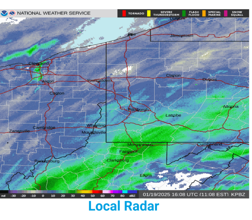
-
Pittsburgh/Western PA Winter 2024-2025 Thread
RitualOfTheTrout replied to Rd9108's topic in Upstate New York/Pennsylvania
Thats where I'm at, 1-2. Other than helping this Jan with below average for the record books the lack of a decent storm preceding or much if any snow during I'm already sort of looking forward to moderating by next weekend. Usually a true arctic airmass like what is coming has squalls or something when it goes through but not seeing anything like that. -
Pittsburgh/Western PA Winter 2024-2025 Thread
RitualOfTheTrout replied to Rd9108's topic in Upstate New York/Pennsylvania
That would be nice, Euro and GFS have us right on the fringe. Another 50 mile NW shift on those two would put most of us into a 2-4 range. This time there isn't a giant vortex or Northern stream interference so maybe we get a continued subtle trend north as we close in. -
Pittsburgh/Western PA Winter 2024-2025 Thread
RitualOfTheTrout replied to Rd9108's topic in Upstate New York/Pennsylvania
Sleet and zr here currently. Light glaze on the car, pavement seems fine. Expect it will be pretty short lived before plain rain takes over. -
Pittsburgh/Western PA Winter 2024-2025 Thread
RitualOfTheTrout replied to Rd9108's topic in Upstate New York/Pennsylvania
Canadian models owe us something after all the headfakes showing a big storm over the years only to cave to the no snow models. Time to pay the bill and score a coop maybe? Lol -
Pittsburgh/Western PA Winter 2024-2025 Thread
RitualOfTheTrout replied to Rd9108's topic in Upstate New York/Pennsylvania
Keeping an eye on Saturday, NAM looked a little thumpy before mix. I hope we can hold onto the pack through the arctic outbreak just to keep snow otg streak going. Getting another inch or two before we warm up enough for rain / mix would go a long way to helping with that. -
Pittsburgh/Western PA Winter 2024-2025 Thread
RitualOfTheTrout replied to Rd9108's topic in Upstate New York/Pennsylvania
City looks to get raked, just in time for rush hour. -
Pittsburgh/Western PA Winter 2024-2025 Thread
RitualOfTheTrout replied to Rd9108's topic in Upstate New York/Pennsylvania
RGEM and CMC are the furthest NW, but even those we are fringed a bit. Pinpointing when the boundary gets hung up is not a high confidence forecast but looks like GFS finally jumped onboard of there even being a storm. Looks like a pretty good slug about to move through. Planning on leaving work early, but may need to head out a bit earlier to enjoy those heavier returns (and avoid the evening commute disaster that is Pittsburgh traffic lol). -
Pittsburgh/Western PA Winter 2024-2025 Thread
RitualOfTheTrout replied to Rd9108's topic in Upstate New York/Pennsylvania
Ill be at work, oh who am I kidding ill be looking out the window and watching radar either way lol. It will be interesting to see if anyone gets lucky with banding.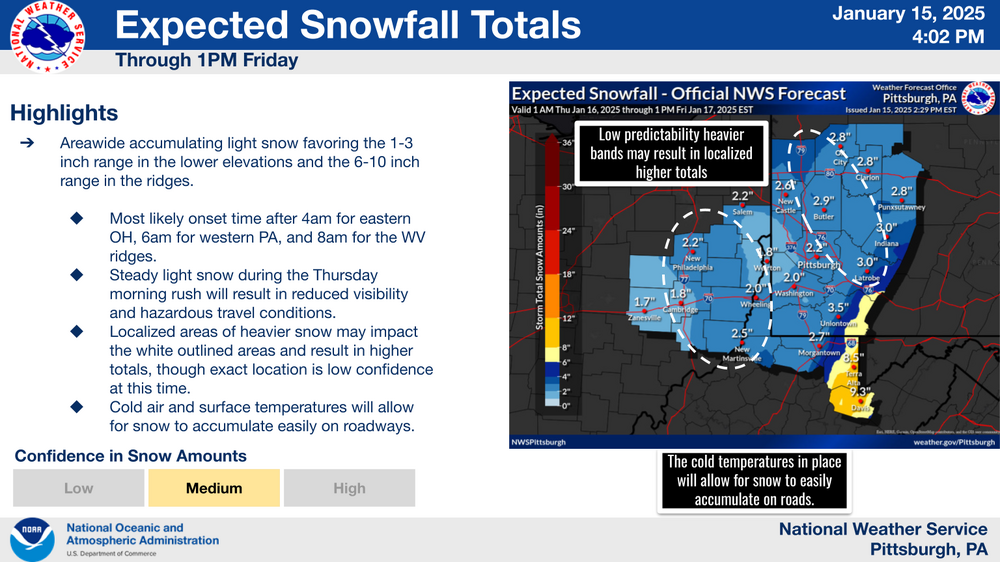
-
Pittsburgh/Western PA Winter 2024-2025 Thread
RitualOfTheTrout replied to Rd9108's topic in Upstate New York/Pennsylvania
Thursday does look a little more robust right now. Could be another 1-2 for sure. Closing in on a fresh inch right now. -
Pittsburgh/Western PA Winter 2024-2025 Thread
RitualOfTheTrout replied to Rd9108's topic in Upstate New York/Pennsylvania
Light snow and temperature at 16, deep winter! Maybe we can squeeze a couple inches out of these next 2 light events. Saturday looks mixy, maybe it can trend better. Next week still looks interesting too. -
Pittsburgh/Western PA Winter 2024-2025 Thread
RitualOfTheTrout replied to Rd9108's topic in Upstate New York/Pennsylvania
I think after 2 solid weeks of relatively deep cold and NW flow I'll be ready to roll the dice on something with higher upside. Once the lakes start to ice over this current pattern will lose most of any potential upside options outside of a vigorous clipper or miller B type redevelopment. Now that the we look to be heading more towards a +NAO and -EPO I'd expect some cold outbreaks but they should be more progressive. A more moisture laden or overrunning event event even if we mix or rain for a portion wouldn't be the worst, of course an all snow event would be fine too. The type of setup being advertised is more likely to end up further NW outside of some perfectly timed northern stream vort squashing everything so seeing things a little more SE right now isn't the worst. Never any guarantees so hopefully the interesting looks for next week hold. Crazy how balmy 31 degrees felt this morning. -
Pittsburgh/Western PA Winter 2024-2025 Thread
RitualOfTheTrout replied to Rd9108's topic in Upstate New York/Pennsylvania
Dang, to bad the gfs ends at 384, it was in the middle of an epic storm, we are getting a major ice storm after 8-12 of snow with more fun on the way. (For entertainment purposes only)
-
Pittsburgh/Western PA Winter 2024-2025 Thread
RitualOfTheTrout replied to Rd9108's topic in Upstate New York/Pennsylvania
Measured between half an inch to 3/4. Disappointing from a totals perspective but refreshed the wintry scenery at least. -
Pittsburgh/Western PA Winter 2024-2025 Thread
RitualOfTheTrout replied to Rd9108's topic in Upstate New York/Pennsylvania
Finally getting some light snow. -
Pittsburgh/Western PA Winter 2024-2025 Thread
RitualOfTheTrout replied to Rd9108's topic in Upstate New York/Pennsylvania
Hrrr has the hole modeled pretty well, also shows it filling in later but I think the damage is done given we've missed a couple hours of snow already.
-
Pittsburgh/Western PA Winter 2024-2025 Thread
RitualOfTheTrout replied to Rd9108's topic in Upstate New York/Pennsylvania
Hole is pretty much right over my house.
-
Pittsburgh/Western PA Winter 2024-2025 Thread
RitualOfTheTrout replied to Rd9108's topic in Upstate New York/Pennsylvania
Yeah, I was a little worried several short range models showed that better banding NW of the city. Some areas already with 2-4 on the ground that weren't even in an advisory until they just recently upgraded. Still need to see how it plays out but nothing but a few flurries here so far. Probably will be lucky to get much more than an inch. -
Pittsburgh/Western PA Winter 2024-2025 Thread
RitualOfTheTrout replied to Rd9108's topic in Upstate New York/Pennsylvania
Everything mostly in agreement for a general 1-3. Ill take it. -
Pittsburgh/Western PA Winter 2024-2025 Thread
RitualOfTheTrout replied to Rd9108's topic in Upstate New York/Pennsylvania
Yeah it's back, pretty steady heavier light snow if that makes any sense lol. Those big puffy dendrites though so it adds up. Probably 1-2 since midnight but hard to tell with the blowing. Looks like 2 or 3 clippers next week. I always preferred the "Saskatchewan Screamer" If I was ever musically inclined I would have started a punk band with that name. lol -
Pittsburgh/Western PA Winter 2024-2025 Thread
RitualOfTheTrout replied to Rd9108's topic in Upstate New York/Pennsylvania
That northern stream piece is what's going to give us whatever we get. Honestly, the big phased look was probably going to fringe us, maybe we end up worse off with that look so this might end up better for "more snow" anyways. -
Pittsburgh/Western PA Winter 2024-2025 Thread
RitualOfTheTrout replied to Rd9108's topic in Upstate New York/Pennsylvania
Yeah, I feel like when I was a kid we almost always had a stretch like this in winter. I remember getting smaller-ish storms, and sled riding then followed up like every other day getting another 1-3 or 2-4 with snow on the ground adding fresh powder to our sled runs lol I'm sure my memory makes it seem more frequent than it probably was but this is the type of stretch I've been missing. Still wouldn't be mad if we scored a bigger storm somewhere along the way. -
Pittsburgh/Western PA Winter 2024-2025 Thread
RitualOfTheTrout replied to Rd9108's topic in Upstate New York/Pennsylvania
Getting moderate snow here now, wind is really blowing too! These types of days are our bread and butter lol