RitualOfTheTrout
-
Posts
3,693 -
Joined
-
Last visited
Content Type
Profiles
Blogs
Forums
American Weather
Media Demo
Store
Gallery
Everything posted by RitualOfTheTrout
-

Pittsburgh, Pa Winter 2023-24 Thread.
RitualOfTheTrout replied to meatwad's topic in Upstate New York/Pennsylvania
Sometimes the pattern or setup plays into a models overall bias or particular wheelhouse which maybe allows it to be more "right" for the wrong reason. In this case usually the CMC is the amped up one so to me that was a red flag, but when it's on it's own you usually toss it. Overall, the outcomes across all guidance (ENS / OPs) did show what happened as a possibility, the part I find the strangest is how long it took for them to catch on. Anyways, what a storm, rates are ridiculous out here, maybe 120,000 lumens per second.
-
Pittsburgh, Pa Winter 2023-24 Thread.
RitualOfTheTrout replied to meatwad's topic in Upstate New York/Pennsylvania
Euro just did a big rug pull for a lot of folks.... Here I am looking at this map.. If I can't have her no one can. lol
-
Pittsburgh, Pa Winter 2023-24 Thread.
RitualOfTheTrout replied to meatwad's topic in Upstate New York/Pennsylvania
Is Aaron Lewis secretly a snow weenie.. you listen and be the judge. Feels pretty damn accurate this morning, even if the music isn't your style the lyrics hit through the lens of this hobby. lol -
Pittsburgh, Pa Winter 2023-24 Thread.
RitualOfTheTrout replied to meatwad's topic in Upstate New York/Pennsylvania
This storm was always a long shot, but its starting to look like this "epic" "mint" "awesome" pattern that this storm was just a precursor for is also a brief cold shot, probably similar to the week in January. Nothing we can do, just along for the ride, maybe we get a fluke, or maybe we get an early warm Spring. I'm good with either at this point. -
Pittsburgh, Pa Winter 2023-24 Thread.
RitualOfTheTrout replied to meatwad's topic in Upstate New York/Pennsylvania
Obviously nothing has happened yet, but this was an even riskier low confidence setup. There were models and members in the ENS suites that showed this completely missing so that was always a possible outcome. At this point if it keeps heading this way its going to end up as little to nothing for anyone. It looks like the 06z Euro is continuing the trend, even central PA / further east are probably starting to worry. Honestly, if we can't get at least 3-4 inches, I hope it keeps moving away, at this point the 06z NAM we almost stay completely dry, no rain or snow. I'd prefer that, another tick or two SE with that shield and I get my wish.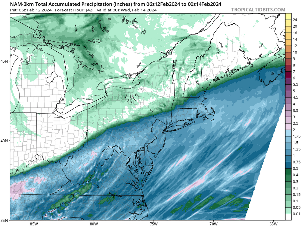
-
Pittsburgh, Pa Winter 2023-24 Thread.
RitualOfTheTrout replied to meatwad's topic in Upstate New York/Pennsylvania
Snow weenie in me said throw out 12z 3k, now we take and throw out the18z 12k lol -
Pittsburgh, Pa Winter 2023-24 Thread.
RitualOfTheTrout replied to meatwad's topic in Upstate New York/Pennsylvania
Dang, Looks like GFS is going to just miss phasing next weekend.
-
Pittsburgh, Pa Winter 2023-24 Thread.
RitualOfTheTrout replied to meatwad's topic in Upstate New York/Pennsylvania
Thats sort of what I was getting at, we could have really set a high bar if it was overcast a few of those nights. -
Pittsburgh, Pa Winter 2023-24 Thread.
RitualOfTheTrout replied to meatwad's topic in Upstate New York/Pennsylvania
Its definitely a hair further South with the low, and subsequently a hair cooler. Too soon to tell if its just noise, or hopefully the start of a series of south adjustments. Im hoping we can at least score a brief period of heavy paste that coats everything so every little bit helps. Its also my opinion whatever "trend" you are seeing leading up in the last 36 hours or so usually continues through game time and verifies a little better if things are improving. That works the other way too, if things are slowing deteriorating odds are it will wind up worse than what models showed. -
Pittsburgh, Pa Winter 2023-24 Thread.
RitualOfTheTrout replied to meatwad's topic in Upstate New York/Pennsylvania
I agree, diurnal minimum for temperatures can only help. To bad we can't get a couple hours of clear sky to radiate. The last week or so that probably helped skew this warmth a bit as we still managed to drop into the 20s a few nights. -
Pittsburgh, Pa Winter 2023-24 Thread.
RitualOfTheTrout replied to meatwad's topic in Upstate New York/Pennsylvania
Its such a narrow margin for victory, minor changes in the handling of that upper low will be all the difference. Im low elevation, and generally my yard does poorly in marginal setups when a few miles any direction is usually significantly better, so I have little optimism. Going to take some good rates to dynamically cool the column and overcome warm surface, but wherever gets that there should be impact, outside of that probably just wet roads etc. Unless the Canadian is right then everyone loses. -
Pittsburgh, Pa Winter 2023-24 Thread.
RitualOfTheTrout replied to meatwad's topic in Upstate New York/Pennsylvania
Its been consistent with doing that in some form. Looping back through the previous runs that SWPA warm tongue / dryslot signal is on display. Crazy the difference in solutions right now on the models. -
Pittsburgh, Pa Winter 2023-24 Thread.
RitualOfTheTrout replied to meatwad's topic in Upstate New York/Pennsylvania
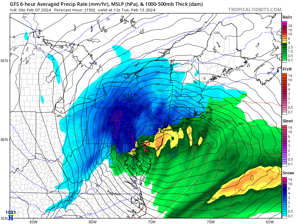
NWS with a good discussion in the uncertainty: .LONG TERM /MONDAY THROUGH FRIDAY/... KEY MESSAGES: - The next potential system will impact the region late Monday into Tuesday, with a range of potential winter weather- related impacts. --------------------------------------------------------------- The cut-off low will develop a coupled surface low over the Mississippi Valley early Monday. As the cut-off draws eastward, it will attempt to re-phase into zonal flow over our area Monday night through Tuesday. In all likelihood, the system will start as rain late Monday. From there, the details get dicey. The strength of the cut-off low will determine various aspects of the surface low behavior. This could play out as a couple scenarios over the forecast area. 1) The upper-low is weaker and phases more rapidly into zonal flow. This would act to keep the surface low track more progressive and farther to the south. Coastal low development would then dominate into Tuesday morning. Because the low track would be farther away, local northerly flow would be weaker. This would lessen the magnitude of cold and dry advection around the backside of the system. An area of frontogenesis is possible, centered over northern West Virginia on the northwest side of the low, though temperatures would likely be too warm to result in snowfall. This solution would result in mostly rain across the area with a lower probability of appreciable snow accumulation. This is reflective of the NBM 10th percentile, where totals amount to zero across the lowlands with a light accumulation for the ridges. 2) The upper low is stronger and slower to re-phase into zonal flow. Though subtle, this would affect surface low behavior and the eventual coastal low development. Under this scenario, ensembles indicate the surface low has a tendency to pull back and collocate under the upper low before the coastal low takes over. This is important. A stronger low across the West Virginia interior could influence three processes. First, stronger north to northeast flow on the northern side of the system would advect cooler and drier Canadian air, capable of wet-bulbing temperatures further. Second, the area of frontogenesis would more likely be in an area that is cold enough to support snowfall. Third, latency time of favorable lift increases as the cut-off is slower to incorporate into the upper flow. These factors could lean towards snowfall amounts toward the higher end of the distribution. Even then, there is still uncertainty with the exact track that the cut-off low may take, adding uncertainty to the area that may see the highest snowfall totals. This scenario is more reflective in the NBM 90th percentile, which shows a sizable tract of 6"+ of snow across western Pennsylvania and the northern West Virginia panhandle. With the spread as large as it is between these two scenarios and still a great deal of uncertainty in track, the current forecast is reflective of some "middle-ground". Though not necessarily the "most-likely" scenario, will opt to continue to trend toward the more likely solution as more information becomes available in subsequent updates. -
Pittsburgh, Pa Winter 2023-24 Thread.
RitualOfTheTrout replied to meatwad's topic in Upstate New York/Pennsylvania
Yeah, this is a high bust potential though 12z Euro did have me raise an eyebrow. -
Pittsburgh, Pa Winter 2023-24 Thread.
RitualOfTheTrout replied to meatwad's topic in Upstate New York/Pennsylvania
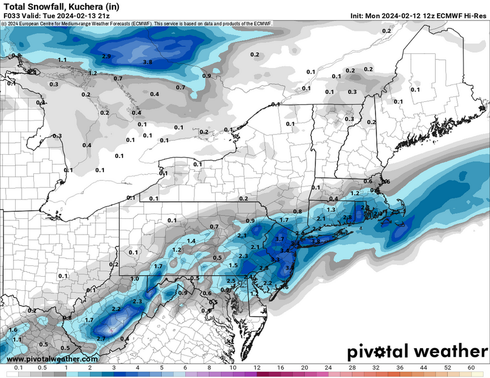
Kuchera method is generally better in marginal events as it more accurately takes into account the effect of temperature in crystal formation and melting thus resulting in a less than 10:1 SLR. It was designed to more accurately represent what you would see if at the end of a storm you go out and stick a ruler in the ground. Conversely, I think it's also useful when it's a cold powder as it can estimate totals at a higher than 10:1 SLR. Anecdotally, if it's been less than the 10:1 maps, one could draw the conclusion we have experienced more borderline snow events in recent history which is what I gather you were trying to get at with this comment. -
Pittsburgh, Pa Winter 2023-24 Thread.
RitualOfTheTrout replied to meatwad's topic in Upstate New York/Pennsylvania
We need some phase to get the NS involved though to get the cold, 6z GFS was really close to perfect, get that whole progression to happen a little faster and further SW and it bombs right over us vs central PA and look out. There in lies the the thread the needle aspect though, there aren't any other features to buy wiggle room, so it all has to time out perfectly which makes it even lower odds than normal. But dang...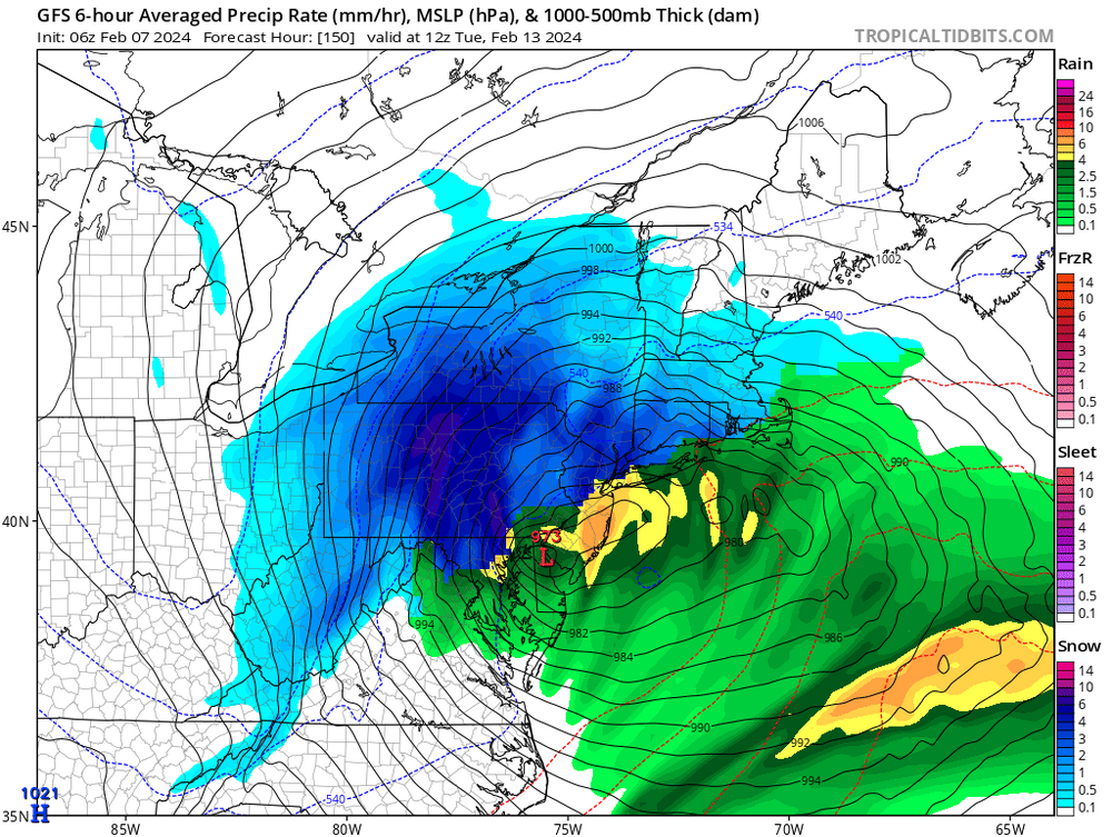
-
Pittsburgh, Pa Winter 2023-24 Thread.
RitualOfTheTrout replied to meatwad's topic in Upstate New York/Pennsylvania
I think it's inevitable a couple threats are suppressed or shredded if we get the blocking the ENS are showing, but I agree on the time of year, by the last week of Feb into early March, a healthy STJ wave might need some extra help to keep it under us. My thoughts on how things evolve would be along these lines: If we can score anything in the Feb 12th - 16th period that would be a bonus (threat the needle / marginal air mass type deal), then the blocking likely pushes most threats to far South 17th-22nd (illustrated in precip anomalies etc.) then 23rd - 29th (Yes don't forget we get an extra day of Feb this year for those worried about the calendar ) might be the first shot at a bigger storm. After that maybe a repeat of that cycle in some form for early March depending how blocking evolves, stuff above my pay grade (weak SPV coupling / MJO progression etc.) might argue for a second round of blocking to re-establish. The deep winter enthusiast in me would prefer this all to be happening a month earlier, but on the other hand if you want to go all in on a "Max Bet" with a good pattern in early March might be the best shot for those big game hunting. Good pattern doesn't guarantee anything, still chaos / luck involved to get something to work out. -
Pittsburgh, Pa Winter 2023-24 Thread.
RitualOfTheTrout replied to meatwad's topic in Upstate New York/Pennsylvania
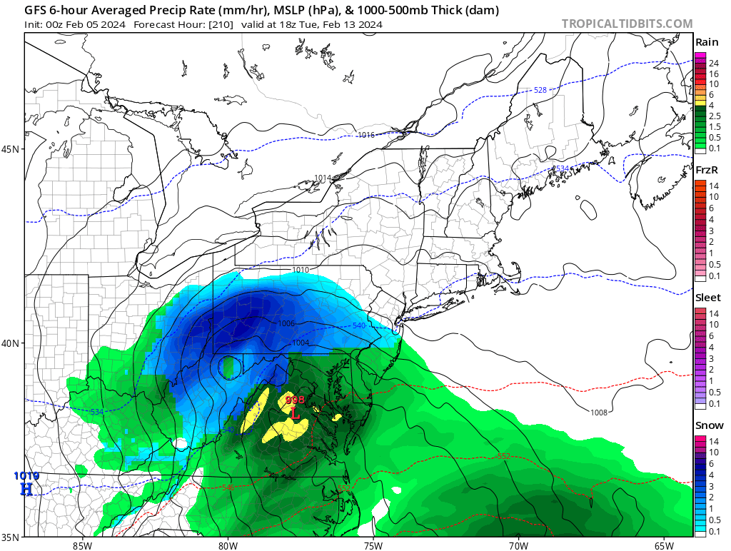
Just posting this 00z GFS solution for some positive energy and morale boost, maybe by this weekend we have something to track besides pretty 500mb patterns?
-
Pittsburgh, Pa Winter 2023-24 Thread.
RitualOfTheTrout replied to meatwad's topic in Upstate New York/Pennsylvania
That and that wave out in the pacific is kicking the sw out into the Atlantic. This could have been a pretty decent storm, maybe not us, had things aligned a bit better. Another missed opportunity. Otherwise I agree, we've got at least a week before there might be something to track, by then the specifics of the pattern change should be more ironed out as well. For now, we are just tracking that the good pattern doesn't start to degrade as it moves up in time or get kicked further into Feb. Another round of blocking might argue the good look sticks around longer than what we had in January, but strong ninos usually favor a warm March so I'm definitely not sold on some 4 week wall to wall winter period setting in either. At least it looks dry AND warm-ish for the next 10 days. -
The warmer oceans, especially on the Atlantic side seem to be leading to more ridging in the SE, makes it harder for the jet stream to dip etc. We constantly see ridges link up to the NAO etc which just nukes any cold air. Clippers generally originate from energy off the pacific, so that whole environment changing due to warmth induced tropical forcing is also a factor. I recall we used to get the PV to sometimes park over Hudson bay more consistently, which provided the perfect avenue to divert the jet stream and those northern stream vorts and associated cold right at us. Clippers with wrap around LES made up a good chunk of our "expected" snow, especially early in the season. December is more like early November in terms of climo now, sometimes you can get a blast of cold, or it gets good towards the end, but the fact the Great Lakes remain ice free into Feb now is crazy. LES was almost always shut down by this time, which might have cut down on our available moisture, but also lost the moderating factor when cold would move in. I do agree our sample sizes are to small to glean much on how things are changing on a scale larger than we can really comprehend within a human lifetime. There are also events in the not to distant past (on a climate timescale anyways) maunder minimum, volcanic eruptions etc. that we don't have a great way to understand how coming out of those vs what the "normal" was prior to make any major takeaways. As you said, there are likely other cyclical patterns within patterns that are constructively interfering to enhance the overall impacts of a warming planet.
-
I'm with you, barely being able to manage a "car topper" in late January is pretty pathetic and depressing, especially when its sandwiched into what is shaping up to be 4 weeks of wasted prime winter. I prefer deep winter, like what we had last week, days and days below freezing with snow cover and frozen ground. If we get a better pattern by mid Feb we can still have a "good" stretch, maybe land a bigger storm, but it gets harder and harder with longer days, higher sun angle and rising avg temperatures to get that deep winter feel by that time. I could care less about March snow unless its a big dog, even then my enjoyment is tempered by hearing birds chirping while I'm shoveling snow and seeing snow melt even though its in the upper 20s.
-
Pittsburgh, Pa Winter 2023-24 Thread.
RitualOfTheTrout replied to meatwad's topic in Upstate New York/Pennsylvania
It's not looking great, going to take near perfect chain of events for that to work out for anyone really. It's just to warm even if you get a good track. It's an interesting look at 500 on the maps, but all the indices being in the wrong phase all but guarantee futility baring a fluke. I must admit I was dead wrong on this period. A 7-10 day thaw was inevitable. I thought by now we would be on the heels of the pattern getting better again in the first week of Feb. Instead, staring down the barrel of flushing 4 prime weeks of winter climo down the toilet and that assumes things "get good" by the 14th. By that time the entire east coast is putting all their eggs in a 2-3 week period to score a couple big storms to salvage the season, and unless we really get on some sort of heater going to be hard to please everyone. -
Pittsburgh, Pa Winter 2023-24 Thread.
RitualOfTheTrout replied to meatwad's topic in Upstate New York/Pennsylvania
Getting some light snow, theres a weak band just to my North. Just enough for that deep winter look and feel. As advertised next week we thaw, its after that which has degraded. Looks like*maybe* a chance at something 30th time frame before the PNA ridge rolls east. MJO forecast shows the wave dying in 6, rather than progressing through 7-8-1. That probably plays some roll in the warmer looks. We also lost the blocking for now. Both of those (MJO / NAO) are not forecast far out with great accuracy, so if that flips could see some major changes on the models after next week. -
Pittsburgh, Pa Winter 2023-24 Thread.
RitualOfTheTrout replied to meatwad's topic in Upstate New York/Pennsylvania
I was surprised they didn't have a special weather statement or something for it. -
Pittsburgh, Pa Winter 2023-24 Thread.
RitualOfTheTrout replied to meatwad's topic in Upstate New York/Pennsylvania
Pretty jealous, would have liked to get in on some of the heavy stuff. Glad some folks cashed in and that band materialized. Seems it made it fairly far SE for a LES band, but that dual lake fetch is usually mobey for someone. I had a burst for about 2 minutes around 5 that put down a fresh dusting.