RitualOfTheTrout
-
Posts
3,693 -
Joined
-
Last visited
Content Type
Profiles
Blogs
Forums
American Weather
Media Demo
Store
Gallery
Everything posted by RitualOfTheTrout
-

Pittsburgh/Western PA Winter 2024-2025 Thread
RitualOfTheTrout replied to Rd9108's topic in Upstate New York/Pennsylvania
Yeah, it seems like lately our region is divided on bigger storms. That Jan 94 storm track was perfect. Really an unusual distribution of snow. -
Pittsburgh/Western PA Winter 2024-2025 Thread
RitualOfTheTrout replied to Rd9108's topic in Upstate New York/Pennsylvania
Yeah, I was going to say December 2020 was definitely double digits. I got stuck at work with an issue that day and drove home after 11pm so that one sticks out but must be skewed by the "single daily" total. That makes it more like 4 years which I'd say is more inline with our statistical odds of that type of event. It doesn't do anything to satisfy the big storm itch though. -
Pittsburgh/Western PA Winter 2024-2025 Thread
RitualOfTheTrout replied to Rd9108's topic in Upstate New York/Pennsylvania
I enjoy the little snows, especially if it stays cold with snow on snow. That being said we are about at the end of realistically keeping snow on the ground so by early March Im much more interested in a bigger storm. Jeff V had a stat today our largest daily snowfall is 2.6 inches (midnight - midnight) and that was last weekend. -
Pittsburgh/Western PA Winter 2024-2025 Thread
RitualOfTheTrout replied to Rd9108's topic in Upstate New York/Pennsylvania
Had one blow through here, lasted almost 10 minutes. Snow was legit heavy. Looks like another round moving in now. -
Pittsburgh/Western PA Winter 2024-2025 Thread
RitualOfTheTrout replied to Rd9108's topic in Upstate New York/Pennsylvania
What could go wrong? Rather see it than not. Would be a great end to winter if we can manage a warning criteria event in the next couple weeks. -
Pittsburgh/Western PA Winter 2024-2025 Thread
RitualOfTheTrout replied to Rd9108's topic in Upstate New York/Pennsylvania
It was a great little event, I agree to bad the first batch got washed out, but better to have snowed and melted than to have never snowed at all. Made the best of yesterday with an impromptu sled and snowman session with the boy. Daughter just got her permit so took her driving tonight to get some bad weather driving experience (some donuts in an empty parking lot too ) then finished it off with dog walk pulling the boy in the sled in heavy snow. Sometimes I think cold and snowy weather gets me more motivated to be outside than warm weather lol -
Pittsburgh/Western PA Winter 2024-2025 Thread
RitualOfTheTrout replied to Rd9108's topic in Upstate New York/Pennsylvania
Looks to be filling in nicely. Id say another inch is doable based on that..gif.ebfd874fb5b0bb50cb6b2fbd97fb890e.gif)
-
Pittsburgh/Western PA Winter 2024-2025 Thread
RitualOfTheTrout replied to Rd9108's topic in Upstate New York/Pennsylvania
Radar indicated change over should be going through Allegheny now. Actually a couple wet flakes mixing here too now. -
Pittsburgh/Western PA Winter 2024-2025 Thread
RitualOfTheTrout replied to Rd9108's topic in Upstate New York/Pennsylvania
I agree, only to add that has been a problem to some extent (fast Pac flow) for more than just this season. -
Pittsburgh/Western PA Winter 2024-2025 Thread
RitualOfTheTrout replied to Rd9108's topic in Upstate New York/Pennsylvania
Right now its really the only model showing it, but its an easier path (All Southern Stream) to something vs what we needed with the big phase. If it can amplify nothing to really suppress it. -
Pittsburgh/Western PA Winter 2024-2025 Thread
RitualOfTheTrout replied to Rd9108's topic in Upstate New York/Pennsylvania
Anytime you are depending on the PV let alone interactions with individual lobes rotating around its absolutely tenuous. To be honest aside from maybe a run of the cmc this was never going to be a huge storm for us anyways. -
Pittsburgh/Western PA Winter 2024-2025 Thread
RitualOfTheTrout replied to Rd9108's topic in Upstate New York/Pennsylvania
Yep, CMC and Euro both a step back from what we need, sloppy phase. Euro compensates a little with a little stronger southern shortwave. Really need that clean early phase. Could still move back to that idea. -
Pittsburgh/Western PA Winter 2024-2025 Thread
RitualOfTheTrout replied to Rd9108's topic in Upstate New York/Pennsylvania
Probably a good sign for the Euro then. Should be rolling in shortly. -
Pittsburgh/Western PA Winter 2024-2025 Thread
RitualOfTheTrout replied to Rd9108's topic in Upstate New York/Pennsylvania
Impromptu sled trip to my parents in southern armstrong. Still ripping snow here 3+, not sure about back home. Great morning! -
Pittsburgh/Western PA Winter 2024-2025 Thread
RitualOfTheTrout replied to Rd9108's topic in Upstate New York/Pennsylvania
Moderate here again too. Big flakes exploding on contact lol. Some rimming on the flake structure is noted now so mixing is probably about to start. -
Pittsburgh/Western PA Winter 2024-2025 Thread
RitualOfTheTrout replied to Rd9108's topic in Upstate New York/Pennsylvania
Looks like 00z Euro and CMC did what jwilison was saying is needed with the faster / cleaner phase. Id take either of those. Im not sure how much better that could get, but like I said yesterday that interaction isn't going to be resolved well yet, and a relatively minor change will have a big effect on us since we need the perfect phase timing to pull it west. -
Pittsburgh/Western PA Winter 2024-2025 Thread
RitualOfTheTrout replied to Rd9108's topic in Upstate New York/Pennsylvania
Nope, just enjoying. Can post about it once the deluge starts. Looks like at least an inch. -
Pittsburgh/Western PA Winter 2024-2025 Thread
RitualOfTheTrout replied to Rd9108's topic in Upstate New York/Pennsylvania
Sometimes you just gotta laugh...
-
Pittsburgh/Western PA Winter 2024-2025 Thread
RitualOfTheTrout replied to Rd9108's topic in Upstate New York/Pennsylvania
I think a best case scenario is probably like 4-6 if we somehow manage that unlikely earlier phase scenario. TPV lobes are mercurial poorly modeled variables wherin small changes can have a pretty large impact on storm development and relying on models to have that accurate at this range is setting yourself up for disappointment. Fingers crossed we pull out a surprise. -
Pittsburgh/Western PA Winter 2024-2025 Thread
RitualOfTheTrout replied to Rd9108's topic in Upstate New York/Pennsylvania
Hard to know for sure what is from tomorrow pre change over and sunday back to snow, but I think I can infer a couple are a little further west maybe. -
Pittsburgh/Western PA Winter 2024-2025 Thread
RitualOfTheTrout replied to Rd9108's topic in Upstate New York/Pennsylvania
Theres to many maps and models to keep track of so no worries. I was hoping I was wrong. I think its possible this *could* come together a little faster and further west which would bring more moisture our way but if I had to bet Id say it goes the other way. Ill be curious to see if any of the eps individuals show that scenario, or if the op is about the best case. -
Pittsburgh/Western PA Winter 2024-2025 Thread
RitualOfTheTrout replied to Rd9108's topic in Upstate New York/Pennsylvania
But even it being the most amped is like 2-4 inches (based on .3qpf) or am I missing something? Its still pretty far east with the low. -
Pittsburgh/Western PA Winter 2024-2025 Thread
RitualOfTheTrout replied to Rd9108's topic in Upstate New York/Pennsylvania
Honestly our best bet was the storm tomorrow. Once the PV started getting modeled further west which was needed to supress the flow a bit and keep it from going to far NW we were cooked. Next week always looked like a coastal. Baring some insane perfect timed phase with a piece of the PV the best we can probably hope for is to grab a 4-6 inch type deal off the NW side and even that might be a stretch. -
Pittsburgh/Western PA Winter 2024-2025 Thread
RitualOfTheTrout replied to Rd9108's topic in Upstate New York/Pennsylvania
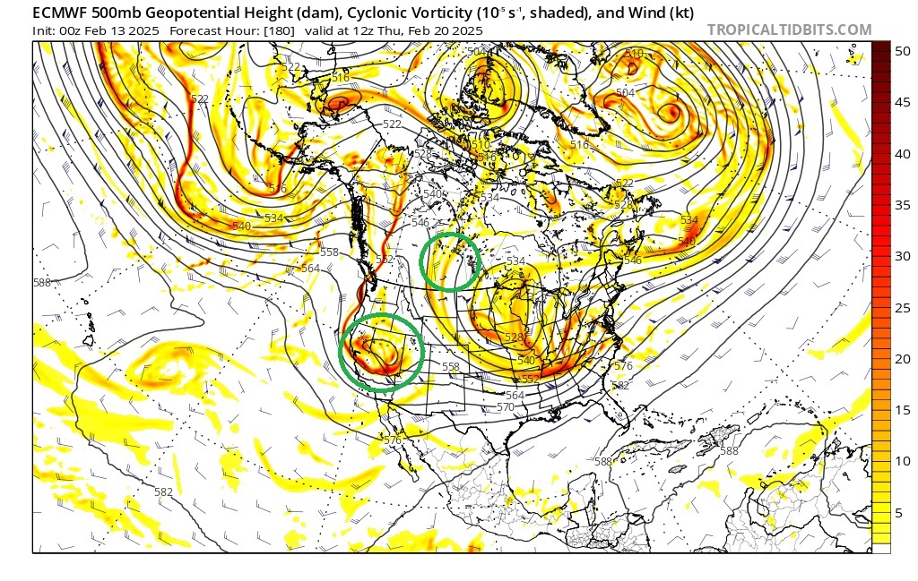
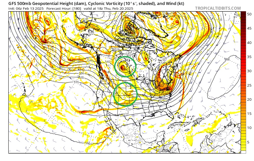
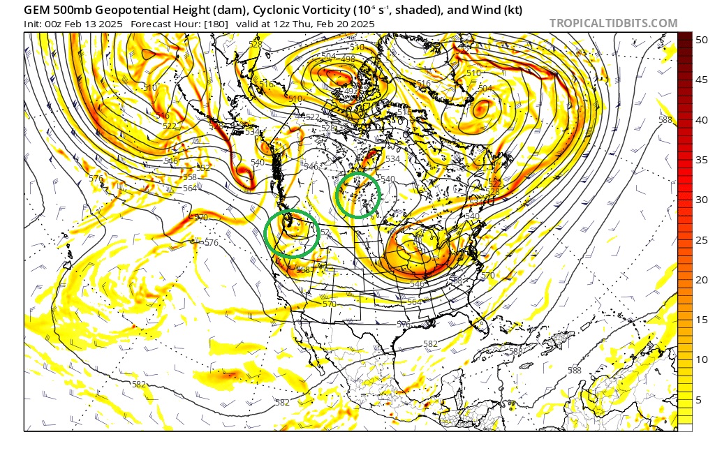
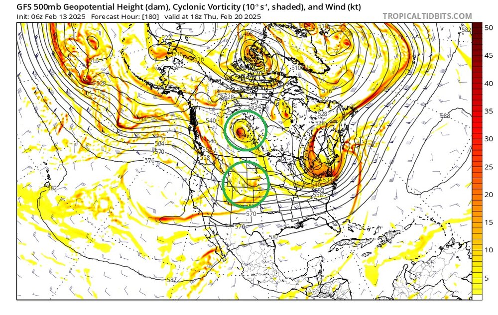
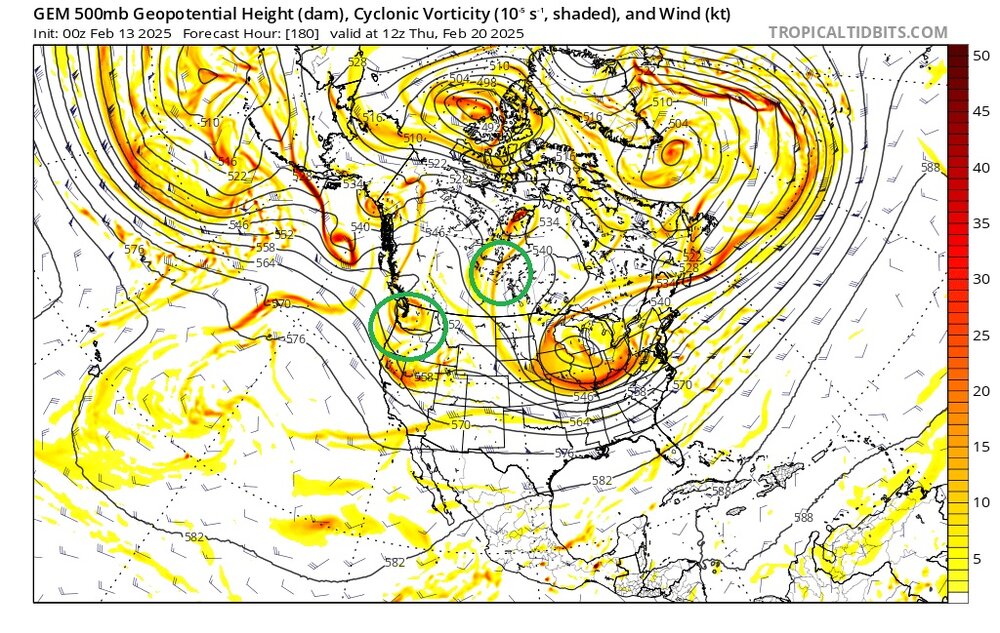
Euro has an interesting setup for the possible storm next week, but a couple key differences with the GFS which is further SE / faster. Euro digs the energy coming in off the PAC into a closed low in the SW partially at least due to the ridge out west not getting knocked down allowing the storm to slow down and consolidate the energy allowing for an almost double barrel type low look getting good snow into our area. GFS on the other hand has the ridge getting knocked down with that piece in Canada allowing the energy to move east and kick the storm out before it can get it's act together. CMC seems a bit slower bringing that PAC energy on shore but also starts to dig it a bit and is much more Euro like. That will be what I keep an eye on as we get closer to this potential. It's been hard to slow the PAC down lately, so my gut says the GFS may be closer to right here, but it's so far out right now some of those variables may not even be there as we close in or something else could manifest to counteract.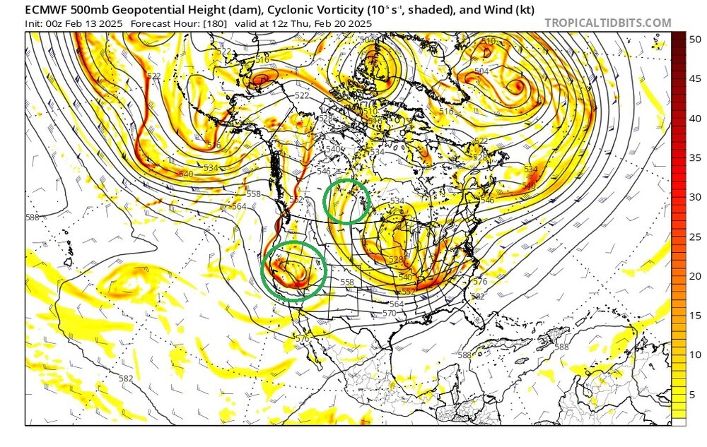
-
Pittsburgh/Western PA Winter 2024-2025 Thread
RitualOfTheTrout replied to Rd9108's topic in Upstate New York/Pennsylvania
Maybe some heavy snow / squalls this afternoon and evening. Not much else going on unless you like to track flood watches Saturday into Sunday. In the wake of the cold front, expected an uptick in snow shower/snow band activity between 4pm to 7pm with a passing shortwave. Hi-Res models depict reflectivity returns of 20DBZ to 30DBZ with snow bands which could create hazardous travel and visibility concerns. The snow squall parameter is also maximized between 20Z Thurs to 00Z Friday over western PA due to steep lapse rates and instability values between 40J/kg to 75J/kg. Short-fused Special Weather Statements (SPS) or Snow Squall Warnings may be needed this evening. Probability of 1"/hr snowfall rates are low (less than 10%) but 0.3"/hr to 0.5"/hr could be embedded within bands.