RitualOfTheTrout
-
Posts
3,693 -
Joined
-
Last visited
Content Type
Profiles
Blogs
Forums
American Weather
Media Demo
Store
Gallery
Everything posted by RitualOfTheTrout
-

Pittsburgh/Western PA WINTER ‘25/‘26
RitualOfTheTrout replied to Burghblizz's topic in Upstate New York/Pennsylvania
If you loop through the runs, it looks like the GFS is progressively getting weaker and weaker for the Sunday thing. Couple that with it not showing on any other guidance and I think we know how this will go. -
Pittsburgh/Western PA WINTER ‘25/‘26
RitualOfTheTrout replied to Burghblizz's topic in Upstate New York/Pennsylvania
Clipper still looking solid for Friday. 1-3 inches if I had to guess now. Those wanting a warmup, looks like after this arctic hit this weekend things will moderate. Looks a bit more active too, but rain and storms cutting west will be back on the table. -
Pittsburgh/Western PA WINTER ‘25/‘26
RitualOfTheTrout replied to Burghblizz's topic in Upstate New York/Pennsylvania
Kidding.. sorta. Cold would be more fun if we had a couple light events. Had the kids do water balloons with food coloring and we set them out to freeze and then peel the balloons off to make abstract ice art. Running out of interesting things to do. Need another storm before we moderate next week. -
Pittsburgh/Western PA WINTER ‘25/‘26
RitualOfTheTrout replied to Burghblizz's topic in Upstate New York/Pennsylvania
Right now the Friday clipper has the best shot at a region wide impact. Crazy by then it will have been almost two weeks since our big storm and its been mainly dry since. The lakes freezing over has limited any benefit of the NW flow outside of a few dustings. Not high on the mid week thing, looks like more of an I70 south thing. Ill be curious to see how things look after next weekend. Some hints we might finally warm up closer to average at least temporarily. -
Pittsburgh/Western PA WINTER ‘25/‘26
RitualOfTheTrout replied to Burghblizz's topic in Upstate New York/Pennsylvania
I think we are well on the way to breaking the record again tonight. Already -2 here, with some -10s showing up on weather underground stations. -
Pittsburgh/Western PA WINTER ‘25/‘26
RitualOfTheTrout replied to Burghblizz's topic in Upstate New York/Pennsylvania
That model has been doing well. -
Pittsburgh/Western PA WINTER ‘25/‘26
RitualOfTheTrout replied to Burghblizz's topic in Upstate New York/Pennsylvania
While we wait for the next threat, this is a pretty good read on what to expect for February: Also, never heard of this process before in the NWS discussion. I was curious why we were seeing light snow this morning. KEY MESSAGE 2... Low chances of flurries will continue through the next few days, likely maximizing each afternoon. This is because of incredibly efficient Burgeron-Fendisen processes in mixed phase clouds, making it very easy for any cloud to produce ice crystals. Each afternoon, this will be slightly enhanced by diurnal heating and destabilization, and the fact that the near-surface layer will peak into the DGZ with warming. -
Pittsburgh/Western PA WINTER ‘25/‘26
RitualOfTheTrout replied to Burghblizz's topic in Upstate New York/Pennsylvania
Yeah, we are toast on this one I'd say, barring some crazy fail of all guidance. Honestly, it's a terrible waste of potential for most of the east. Outside of some light clipper type systems, I think we need to get past the brutal cold this weekend and see if anything can spin up as it relaxes a little bit. -
Pittsburgh/Western PA WINTER ‘25/‘26
RitualOfTheTrout replied to Burghblizz's topic in Upstate New York/Pennsylvania
I think we want that whole progression to happen further north, snow is almost at the pa line. I think its to much to ask for the coastal to be far enough inland to give us anything. All of this of course assumes the GFS doesn't cave to everything else anyways. -
Pittsburgh/Western PA WINTER ‘25/‘26
RitualOfTheTrout replied to Burghblizz's topic in Upstate New York/Pennsylvania
Brief burst of heavy snow. Picked up another quick coating in about 5 minutes. -
Pittsburgh/Western PA WINTER ‘25/‘26
RitualOfTheTrout replied to Burghblizz's topic in Upstate New York/Pennsylvania
Light to moderate snow, 9 degrees and wind is whipping up. Pure deep winter out there right now! -
Pittsburgh/Western PA WINTER ‘25/‘26
RitualOfTheTrout replied to Burghblizz's topic in Upstate New York/Pennsylvania
Couldn't have asked for a better day after the storm yesterday. Deep cold and on and off mood flakes / fresh coatings. Looks like another round of light snow today, probably a coating to an inch type deal. Weekend threat isn't dead, but odds are low for any impact here. NWS take on the situation: In one scenario, the upper low occludes earlier (Friday into Saturday), forcing surface cyclogenesis tighter to the coast. In this scenario, there may be ascent in the northwest quadrant of the low and the potential for frontogenetical banding (highest probability in western/central PA and northern WV). Using a quick probability of 0.15" QPF (approx 3" of snow at 20:1), this would produce ~60% chance of at least advisory snows. Though this scenario is around 25% likely overall. In the other scenario, the trough either does not produce a closed low or produces a closed low too late and off the Atlantic coast. This would produce cyclogenesis too far east, only resulting in a ~10% chance of advisory snows. This scenario is 75% likely overall. -
Pittsburgh/Western PA WINTER ‘25/‘26
RitualOfTheTrout replied to Burghblizz's topic in Upstate New York/Pennsylvania
I feel like this one probably has a limit on how far NW it can come. The pieces that set it off are fairly close in time already, so not a lot of time for big adjustments. That being said, still something to track for now. NWS makes mention in the discussion too: KEY MESSAGE 3... Confidence remains high that cold temperatures will persist into early February, as the large-scale pattern continues to favor a strong ridge along the West Coast and a corresponding trough over the East Coast, allowing cold Canadian air to be driven southward. As a result, daytime temperatures are expected to remain below freezing throughout this period, generally ranging from the low to upper-teens. With little relief from the cold, frozen pipes will pose the primary infrastructure concern across the region. River ice is likely to continue forming area- wide, with increasing thickness over the coming weeks and likely impact river gauge readings. Multiple models suggest a Nor`easter may develop along the Atlantic Coast late this weekend, warranting close monitoring for potential snow impacts over the next several days. -
Pittsburgh/Western PA WINTER ‘25/‘26
RitualOfTheTrout replied to Burghblizz's topic in Upstate New York/Pennsylvania
Yeah, I am in withdrawal too, I'll do anything for the next storm tracking fix! I would hate if there were some super rare triple phaser and we completely miss out, but I'd also be ok with getting fringed... probably. I will say though the upcoming cold and every other day light refreshers do help take the edge off a little bit. -
Pittsburgh/Western PA WINTER ‘25/‘26
RitualOfTheTrout replied to Burghblizz's topic in Upstate New York/Pennsylvania
Morning everyone, hope you all got some rest, 00z Euro had this beast last night for next weekend: Lets see how this one evolves. Get the ridge out west more north and shift the axis west and this whole progression probably happens further inland. As it stands we still get a glancing hit. Obviously all the caveats 5 days out etc, but something to track at least for now.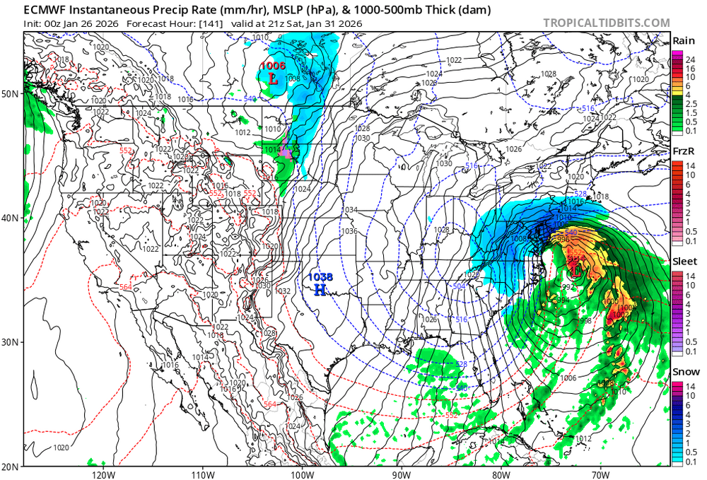
-
Pittsburgh/Western PA WINTER ‘25/‘26
RitualOfTheTrout replied to Burghblizz's topic in Upstate New York/Pennsylvania
Well, I've got more shoveling to do tomorrow. My road is impassible still. Adrenaline is wearing off and maybe ready to go to bed... So who's staying up for 00z runs for what's next!? (Kidding, I think) -
Pittsburgh/Western PA WINTER ‘25/‘26
RitualOfTheTrout replied to Burghblizz's topic in Upstate New York/Pennsylvania
I'm with you, I mean we all rate an event based on our own sometimes relative metrics, but a 12in storm is a 12in storm no matter what hours it falls. Personally idgaf about official measurements either. I really only care what falls in my yard. Don't get me wrong, a big region wide storm like this one is way more enjoyable, but say the official site got 12 today and I got freezing rain? How does that official measurement do anything to satisfy my desire to see it snow? Heck, I'd trade a few inches less for cold before and after a storm. This event checked all the boxes for me so nothings going to bring me down on it that's for sure. I had a blast tracking it with everyone, and the excitement when it started moving NW and really hammering us is priceless. -
Pittsburgh/Western PA WINTER ‘25/‘26
RitualOfTheTrout replied to Burghblizz's topic in Upstate New York/Pennsylvania
This band coming in should be good ratios. -
Pittsburgh/Western PA WINTER ‘25/‘26
RitualOfTheTrout replied to Burghblizz's topic in Upstate New York/Pennsylvania
Same, just a hair under 11. No way we don't get one more inch minimum. -
Pittsburgh/Western PA WINTER ‘25/‘26
RitualOfTheTrout replied to Burghblizz's topic in Upstate New York/Pennsylvania
Indeed! I'm so glad we got this storm on the front end rather than right before it breaks. -
Pittsburgh/Western PA WINTER ‘25/‘26
RitualOfTheTrout replied to Burghblizz's topic in Upstate New York/Pennsylvania
Tomorrow night is going to be brutal. That wind will be blowing the snow around, maybe some borderline ground blizzard conditions. KEY MESSAGE 2... With wind gusts of 20-30 mph and 850mb temperatures falling to near -20 Celsius late Monday, temperatures will drop near zero. Wind chill values have the potential to drop as low as -25F. An Extreme Cold Watch is in effect Monday night into early Tuesday. -
Pittsburgh/Western PA WINTER ‘25/‘26
RitualOfTheTrout replied to Burghblizz's topic in Upstate New York/Pennsylvania
I don't think naming winter storms has caught on anywhere outside of the people who work at the weather channel. I don't think I've heard any other media outlets use that name. Sure regionally events gets names that catch on nationally ala snowmagedon. I tend to remember storms based on the year. -
Pittsburgh/Western PA WINTER ‘25/‘26
RitualOfTheTrout replied to Burghblizz's topic in Upstate New York/Pennsylvania
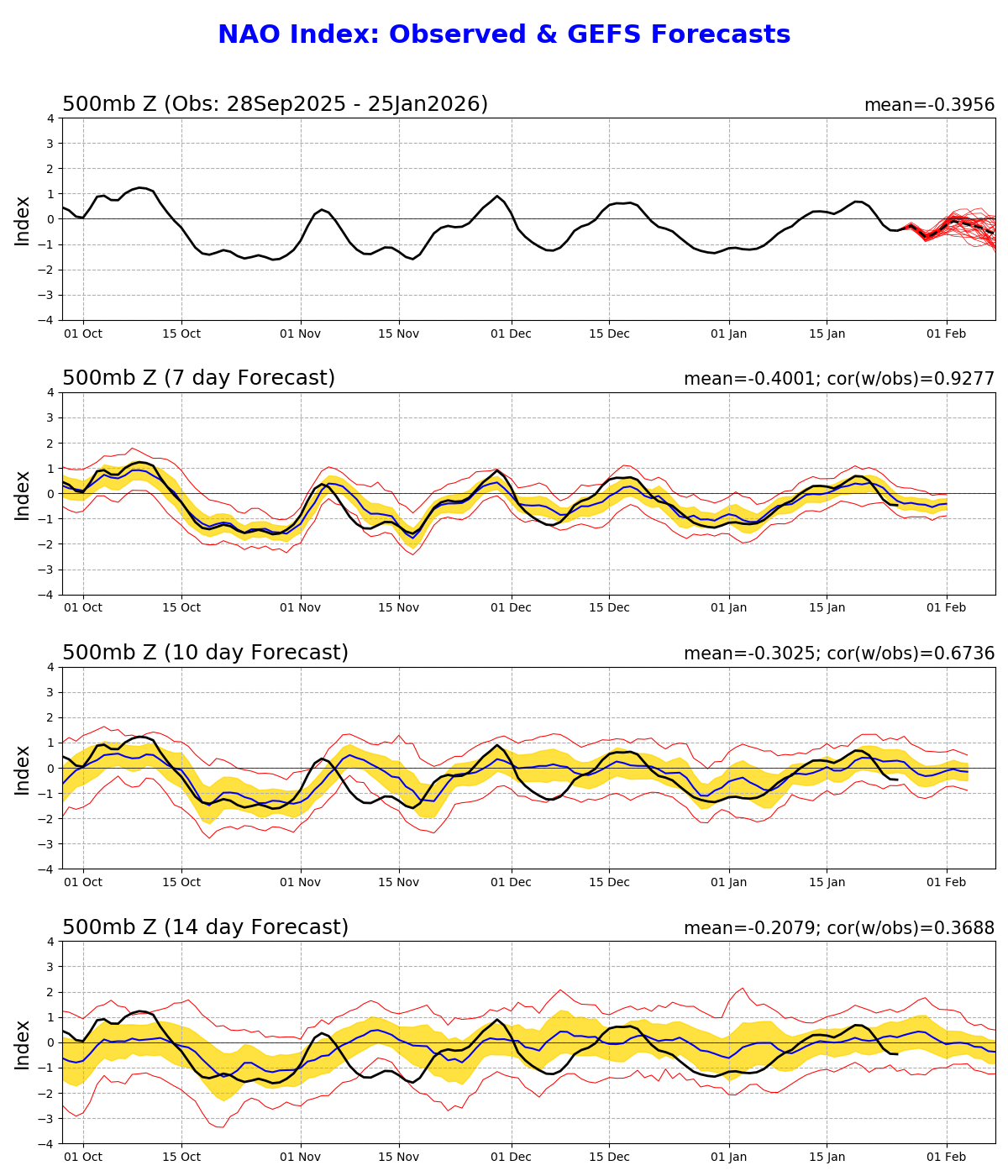
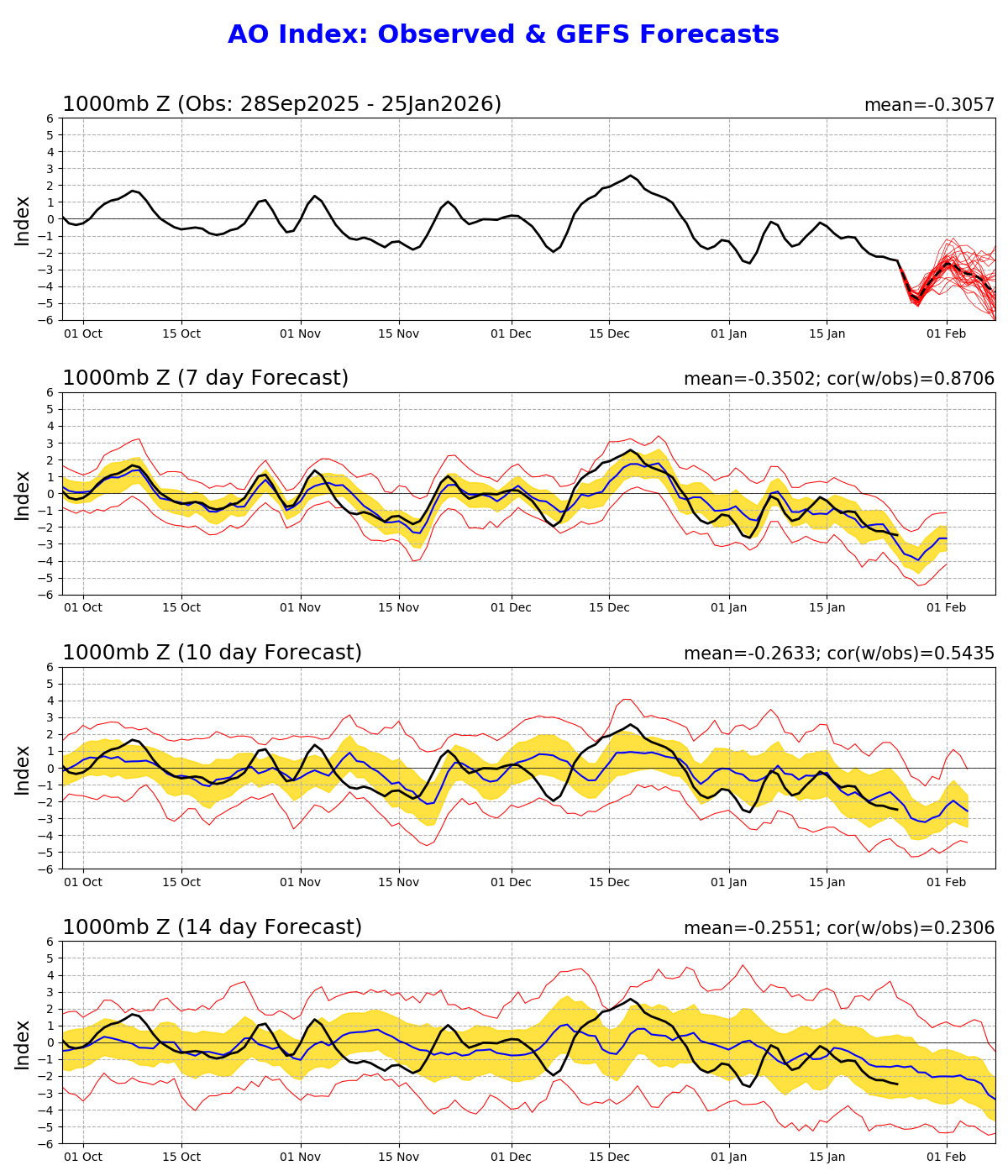
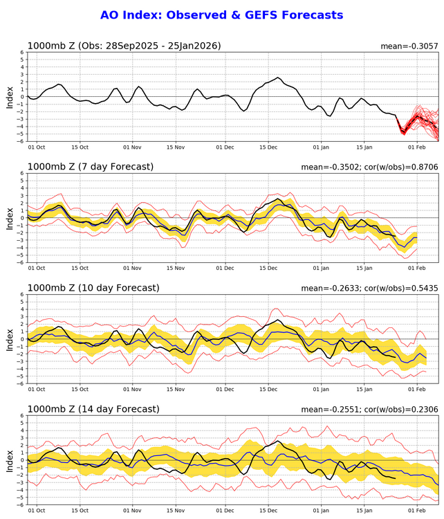
Yeah, blocking could have maybe pushed this to another tier, but I can't complain. AO looks to stay strongly negative, while NAO is negative / neutral. Argues for at least a couple more storm chances into Feb as those wax and wane while helping to keep us cold.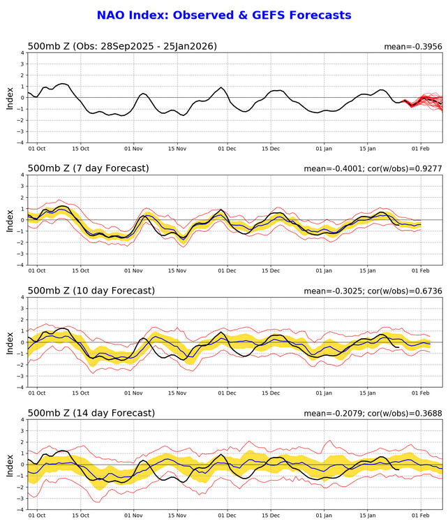
-
Pittsburgh/Western PA WINTER ‘25/‘26
RitualOfTheTrout replied to Burghblizz's topic in Upstate New York/Pennsylvania
Noticed the wind is picking up a little bit and some drifts hanging off the roof. Usually they form on the back of the house, but these are in the front. -
Pittsburgh/Western PA WINTER ‘25/‘26
RitualOfTheTrout replied to Burghblizz's topic in Upstate New York/Pennsylvania
Im not sure its transferring earlier, seems to be on track. It will start to lose energy as it transfers, but that's also going to save us from the warm air aloft surging to far north.