Roger Smith
-
Posts
5,927 -
Joined
-
Last visited
Content Type
Profiles
Blogs
Forums
American Weather
Media Demo
Store
Gallery
Everything posted by Roger Smith
-
Will say 1492 and first high risk a major outbreak in the south-central states around Feb 8th-9th.
-
Oops, no tie-breaker. But I don;t foresee being tied so there you go. Not looking too bad on the long-range charts for an early end to frost-free season, question might be, would all four go at the same time? Takes a fairly potent cold shot to do that, I would assume, with DCA in such a warmed up location and RIC further south.
-
Occasional Thoughts on Climate Change
Roger Smith replied to donsutherland1's topic in Climate Change
Given that voters in most countries are divided on their level of concern about climate change, I think the best political solution is to reshape the paradigm and take climate change out of the equation to some extent, focusing instead on benefits in general from alternative (non-fossil-fuel) energy sources. If there are demonstrable benefits from such a transition, then the climate change issue fades into the background. Another change in political emphasis should be towards mitigation of problems. Whether the alleged problems are caused by AGW, other forms of natural variability, or non-climate factors, these problems need to be addressed. For example, forest fires (or wildfires) are said to be increasing. Maybe they are, maybe not. But more to the point, an advanced society should be able to manage this problem. It is probably more cpmplex than just AGW forcing more fires. There are questions like changing lifestyles (the exurban population increasing rapidly), interface questions, and philosophies about fighting or containing fires. So that sort of climate-related issue can be approached as a self-contained problem that the climate is not a key factor in controlling, in fact it would make a lot of sense to have large changes in our management of the wildfire issue, regardless of what the climate is doing or not doing. To some extent, I think the climate "emergency" is overblown hype, those who peddle it for political gain seem to have no knowledge whatsoever of the range of past weather and climate events. There may be subtle changes as part of AGW, or what we see may be just inevitable natural variability. Either way, it's a safe bet that nothing we do will actually change the future weather observed on our planet by more than a very slight amount. So knowing that, we should have mitigation strategies in place, rather than dealing in these fantasies about paying a tax on carbon to change the weather. That simply isn't going to happen, no matter how many people say so with whatever level of urgency and passion.If the oceans begin to rise in a more dramatic fashion, what can be done about it? Plans must be drawn up for protection or even removal of critical infrastructure, and populations at risk, but only when it becomes apparent that there is no alternative. I don't say this to make denial a policy, I say it because it is the only rational approach. The political parties who deal in a tax-to-solve approach are just deluding themselves and their voters. Their plans cannot possibly work. Mitigation might include diversion of some ocean water into massive desalination/irrigation projects which are needed anyway for other reasons. This is what we should be doing, rather than taxing carbon. -
All four very early 10/17 in massive wintry outbreak from Midwest.
-
The August 21, 2017 Great American Eclipse
Roger Smith replied to ice1972's topic in Weather Forecasting and Discussion
April 8, 2024 ... long totality from west TX northeast to upstate NY and Quebec. Bound to be some cloud along that line but should be within reach of most people on the forum with a bit of planning (my target would be west TX, unless a week in advance it looks like a big high over Quebec then I can go there instead). -
If highs are in the 38-43 F range I would expect you would lose about 2" a day mostly to sublimation (loss into the air as water vapor). As I mentioned before the storm, we had a similar snowfall here last Wednesday that was unrelated to your storm except it happened at a similar temperature and we've had those sorts of temperatures since, and I still have full snow cover of about 2-3" here today. If it gets much above 43 F though, it's going to disappear in two or three days or so except in deeper shade. Since there's some chance of a top-up on Friday, I would expect you will get to that event with half your snow pack intact, and of course all large snow piles will start melting down a bit, but those will last until there's three or four very mild days and/or some heavy rain.
-
also IAD 10.6 storm total, BWI 6.6
-
As of mid-day climo reports, storm totals appear to be 5.4" DCA, 5.6" BWI and 7.1" IAD. Will likely add to all those with final reports.
-
Euro 192h ... this x5
-
Nice, I went from dividing by 3 to multiplying by 2. (final calls 7.0 for all three major airports, DCA should say 9.0, CHO 12.5)
-
Guess The Date Of The Next 12"+ Snowstorm In The OKX Zones
Roger Smith replied to bluewave's topic in New York City Metro
Feb 3rd 2019. -
So 18z would be about 1-2 hours before sunrise there? Damage will be enormous from the looks of those images.
-
Looks like the eye is headed for either eastern Shikoku or the strait between that island and Honshu but in any case a second landfall will occur near Kobe just west of Osaka. Given the populations and port infrastructure of the two landfall areas, the second one will be more problematic. Hoping the first one weakens the storm enough that the second landfall will be less intense, perhaps a strong cat-1 as opposed to 2. Well it won't be long now looking at radar and satellite animations, the thing is accelerating NNE-ward. Roughly 15-20 million people live in the Osaka region then there's Nagoya one bay east, five million more there.
-
Since it's 945 mb out in the open Pacific now, more likely to be around 950-955 at landfall perhaps? Seems to be only a strong cat-2 or weak cat-3 at present.
-
Will have some on-scene reports from my travelling friends who are going to ride this out in Kyoto, supposed to be within 50 miles of the eye around 06z to 08z (Tuesday afternoon JST). This is a radar I will be watching to check the exact track of Jebi. http://www.jma.go.jp/en/radnowc/ Good satellite imagery here: http://www.jma.go.jp/en/gms150jp/ It is midnight in the region now so about 12-15 hours to landfalls and impacts (first Shikoku Island, eastern half, then near Kobe west of Osaka, storm accelerates and moves across Honshu in a few hours and then at TS intensity up the north coast as far as western Hokkaido). My friends are in a modern style hotel that is a smaller building than some nearby, and the whole area is flat but 45 metres above sea level so I'm thinking no real flooding or tsunami potential, they are also on the west side of the building so much of the storm will be producing east to south winds and they are relatively sheltered from those. If the track stays a bit west, should be close to remnants of eyewall during height of storm, hoping for some interesting accounts if not pictures. Told them to expect a bit of a cleanup day outside on Wednesday then back to normal.
-
12z GFS shows Jebi striking the central Honshu coast on Tuesday around 10-12z (late evening Japanese time) with central pressures remaining sub-920 mb. Looks very similar to Katrina on these maps. The current landfall zone is south of Osaka placing Nagoya and Chita in the forward sector but Osaka and Kyoto very close to the fast-moving eye as it swerves northeast. I've been advising travelling friends who at this point are booked into hotel in Kyoto 1st to 4th but main point being this could shift either way so at this point just as safe to be there as Tokyo or far western Honshu. The models have been fairly consistent for days although speeding up the landfall, with respect to central Honshu as the target. Could be a high impact storm for any of these large cities or even Tokyo especially if track shifts east at all. On this track looks like Tokyo would see cat-1 conditions while Nagoya and Chita could see as high as cat-4. You also have to wonder if a significant earthquake would be imminent given these approaching tidal stresses.
-
March 12/13/14 Blizzard/Winter Storm/WWA etc
Roger Smith replied to Bostonseminole's topic in New England
You people throw some mighty fine snow parties. I had two weeks like you're having now, back around end of December and into New Years. That snow is still in my back yard today despite the past five days being sunny and around 40-45 F. -
March 12/13/14 Blizzard/Winter Storm/WWA etc
Roger Smith replied to Bostonseminole's topic in New England
Seems like a movie in the making ... SNOW WARS Long long ago in a snowstorm far away different measurement techniques came into conflict "Luke, where is your snowboard?" -
March 12/13/14 Blizzard/Winter Storm/WWA etc
Roger Smith replied to Bostonseminole's topic in New England
He tried to jump but missed the window wide right. -
March 12/13/14 Blizzard/Winter Storm/WWA etc
Roger Smith replied to Bostonseminole's topic in New England
With this appearance, storm should have been Feb 14th perhaps ..
-
March 12/13/14 Blizzard/Winter Storm/WWA etc
Roger Smith replied to Bostonseminole's topic in New England
Strong pressure falls at 44008 (54 se ACK) to 975.7 mb at 1250z ... estimate center 965 mb at 39.5 N 68.8 W, appears to be phasing with upper low. This will soon overcome the slight warmth left in boundary layer near sea level and become a raging blizzard (where it is not already) in e MA and some parts of RI, e CT. Air temp only 34 F out in Mass Bay over 39 F water, likely to stabilize at about 31/31 at KBOS, S to S+ depending on banding location. Enjoy. -
Southern MD / Lower Eastern Shore weather discussion
Roger Smith replied to AnEndlessMaze's topic in Mid Atlantic
SBY snow reports are not always very timely (from their CF6) so I'm wondering what you think was the actual snowfall at SBY on Wednesday 17th? (data needed for snowfall contest). Thanks. -
Ranking seasons 1851 to 2017 167 North Atlantic tropical storm (or hurricane) seasons are ranked below by number of storms, then by hurricanes, and finally by major hurricanes. (original post) The assumption is made that 2017 will finish 17/10/5 and this assumption will be edited at the end of the season. 2017* may change ranks. It currently stands 9th and would stay there at 18/10/5 or 18/11/5. (edit October 14 at 15z -- NHC upgraded Ophelia to cat-3 which means the assumption has now changed to a finish of 17/10/6 but it will remain 9th at 18/10/6 or 18/11/6.) (update Nov 9th -- With Philippe and Rina in the books now, 2017 has made my guesstimate of 17/10/6. Any further increases will be noted but 2017 remains 9th if it adds one more storm even if that becomes a hurricane.) (update Jan 2018 ... final count confirmed as 17 10 6 for 2017) RANK _ YEAR ___ S __ H __ M _____ RANK __ YEAR ____ S __ H __ M _____ RANK __ YEAR ___ S _ M _ H _ 1 ___ 2005 ___ 28 _ 15 __ 7 ______ 61 ___ 1898 ____ 11 __ 5 __ 1 _____ 119t___ 1972 _____7 _ 3 _ 0 _ 2 ___ 1933 ___ 20 _ 11 __ 6 ______ 62t___ 1974 ____ 11 __ 4 __ 2 _____ 119t___ 1994 _____7 _ 3 _ 0 _ 3 ___ 2010 ___ 19 _ 12 __ 5 ______ 62t___ 2015 ____ 11 __ 4 __ 2 _____ 123 ___ 1858 _____6 _ 6 _ 0 _ 4 ___ 1995 ___ 19 _ 11 __ 5 ______ 64t___ 1937 ____ 11 __ 4 __ 1 _____ 124 ___ 1915 _____6 _ 5 _ 3 _ 5 ___ 1887 ___ 19 _ 11 __ 2 ______ 64t___ 1942 ____ 11 __ 4 __ 1 _____ 125t___ 1875 _____6 _ 5 _ 1 _ 6 ___ 2012 ___ 19 _ 10 __ 2 ______ 66t___ 1869 ____ 10 __ 7 __ 1 _____ 125t___ 1977 _____6 _ 5 _ 1 _ 7 ___ 2011 ___ 19 __ 7 __ 4 ______ 66t___ 1891 ____ 10 __ 7 __ 1 _____ 127 ___ 1941 _____6 _ 4 _ 3 _ 8 ___ 1969 ___ 18 _ 12 __ 5 ______ 66t___ 1903 ____ 10 __ 7 __ 1 _____ 128t___ 1856 _____6 _ 4 _ 2 _ 9 ___ 2017*___ 17 _ 10 __ 6 ______ 69 ___ 1948 ____ 10 __ 6 __ 4 _____ 128t___ 1882 ____ 6 _ 4 _ 2 _10 ___ 1936 ___ 17 __ 7 __ 1 ______ 70 ___ 1976 ____ 10 __ 6 __ 2 _____ 130t___ 1918 _____6 _ 4 _ 1 _11 ___ 1950 ___ 16 _ 11 __ 6 ______ 71 ___ 1908 ____ 10 __ 6 __ 1 _____ 130t___ 1965 _____6 _ 4 _ 1 _12 ___ 2008 ___ 16 __ 8 __ 5 ______ 72t___ 1943 ____ 10 __ 5 __ 2 _____ 132t___ 1904 _____6 _ 4 _ 0 _13t___ 1954 ___ 16 __ 7 __ 3 ______ 72t___ 1947 ____ 10 __ 5 __ 2 _____ 132t___ 1913 _____6 _ 4 _ 0 _13t___ 2003 ___ 16 __ 7 __ 3 ______ 72t___ 1970 ____ 10 __ 5 __ 2 _____ 132t___ 1986 _____6 _ 4 _ 0 _15 ___ 1949 ___ 16 __ 7 __ 2 ______ 72t___ 2006 ____ 10 __ 5 __ 2 _____ 135t___ 1851 _____6 _ 3 _ 1 _16 ___ 1916 ___ 15 _ 10 __ 5 ______ 76 ___ 1899 ____ 10 __ 3 __ 2 _____ 135t___ 1939 _____6 _ 3 _ 1 _17 ___ 2004 ___ 15 __ 9 __ 6 ______ 77 ___ 1963 _____ 9 __ 7 __ 2 _____ 137t___ 1862 _____6 _ 3 _ 0 _18 ___ 2001 ___ 15 __ 9 __ 4 ______ 78 ___ 1975 _____ 9 __ 6 __ 3 _____ 137t___ 1897 _____6 _ 3 _ 0 _19 ___ 2000 ___ 15 __ 8 __ 3 ______ 79 ___ 1888 _____ 9 __ 6 __ 2 _____ 137t___ 1911 _____6 _ 3 _ 0 _20 ___ 1932 ___ 15 __ 6 __ 4 ______ 80 ___ 1867 _____ 9 __ 6 __ 1 _____ 140 ___ 1982 _____6 _ 2 _ 1 _21 ___ 2007 ___ 15 __ 6 __ 2 ______ 81t___ 1889 _____ 9 __ 6 __ 0 _____ 141 ___ 1895 _____6 _ 2 _ 0 _22 ___ 1998 ___ 14 _ 10 __ 3 ______ 81t___ 1940 _____ 9 __ 6 __ 0 _____ 142 ___ 1852 _____5 _ 5 _ 1 _23 ___ 1944 ___ 14 __ 8 __ 3 ______ 83 ___ 1979 _____ 9 __ 5 __ 2 _____ 143 ___ 1876 _____5 _ 4 _ 2 _24 ___ 1990 ___ 14 __ 8 __ 1 ______ 84t___ 1863 _____ 9 __ 5 __ 0 _____ 144 ___ 1855 _____5 _ 4 _ 1 _25 ___ 1953 ___ 14 __ 7 __ 3 ______ 84t___ 1892 _____ 9 __ 5 __ 0 _____ 145t___ 1872 _____5 _ 4 _ 0 _26 ___ 1959 ___ 14 __ 7 __ 2 ______ 86 ___ 1938 _____ 9 __ 4 __ 2 _____ 145t___ 1920 _____5 _ 4 _ 0 _27 ___ 2016 ___ 14 __ 6 __ 2 ______ 87 ___ 1923 _____ 9 __ 4 __ 1 _____ 147 ___ 1873 _____5 _ 3 _ 2 _28 ___ 2013 ___ 14 __ 2 __ 0 ______ 88 ___ 2009 _____ 9 __ 3 __ 2 _____ 148t___ 1854 _____5 _ 3 _ 1 _29 ___ 1955 ___ 13 _ 10 __ 5 ______ 89 ___ 1859 _____ 8 __ 7 __ 1 _____ 148t___ 1910 _____5 _ 3 _ 1 _30 ___ 1996 ___ 13 __ 9 __ 6 ______ 90t___ 1871 _____ 8 __ 6 __ 2 _____ 148t___ 1922 _____5 _ 3 _ 1 _31 ___ 1934 ___ 13 __ 7 __ 1 ______ 90t___ 1879 _____ 8 __ 6 __ 2 _____ 148t___ 1929 _____5 _ 3 _ 1 _32t___ 1901 ___ 13 __ 6 __ 1 ______ 90t___ 2014 _____ 8 __ 6 __ 2 _____ 148t___ 1962 _____5 _ 3 _ 1 _32t___ 1971 ___ 13 __ 6 __ 1 ______ 93t___ 1861 _____ 8 __ 6 __ 0 _____ 153t___ 1864 _____5 _ 3 _ 0 _34 ___ 1984 ___ 13 __ 5 __ 1 ______ 93t___ 1885 _____ 8 __ 6 __ 0 _____ 153t___ 1902 _____5 _ 3 _ 0 _35 ___ 1931 ___ 13 __ 3 __ 1 ______ 95 ___ 1935 _____ 8 __ 5 __ 3 _____ 155 ___ 1919 _____5 _ 2 _ 1 _36 ___ 1893 ___ 12 _ 10 __ 5 ______ 96 ___ 1967 _____ 8 __ 5 __ 1 _____ 156 ___ 1905 _____5 _ 1 _ 1 _37 ___ 1886 ___ 12 _ 10 __ 4 ______ 97t___ 1853 _____ 8 __ 4 __ 2 _____ 157 ___ 1907 _____5 _ 0 _ 0 _38 ___ 1878 ___ 12 _ 10 __ 2 ______ 97t___ 1960 _____ 8 __ 4 __ 2 _____ 158 ___ 1884 _____4 _ 4 _ 1 _39 ___ 1999 ___ 12 __ 8 __ 5 ______ 97t___ 1991 _____ 8 __ 4 __ 2 _____ 159 ___ 1883 _____4 _ 3 _ 2 _40 ___ 1951 ___ 12 __ 8 __ 3 ______100t___ 1927 _____ 8 __ 4 __ 1 _____ 160 ___ 1983 ____ 4 _ 3 _ 1 _41t___ 1958 ___ 12 __ 7 __ 3 ______100t___ 1973 _____ 8 __ 4 __ 1 _____ 161t___ 1857 _____4 _ 3 _ 0 _41t___ 1981 ___ 12 __ 7 __ 3 ______100t___ 1993 _____ 8 __ 4 __ 1 _____ 161t___ 1868 _____4 _ 3 _ 0 _43 ___ 1964 ___ 12 __ 6 __ 6 ______103 ___ 1968 _____ 8 __ 4 __ 0 _____ 163 ___ 1917 _____4 _ 2 _ 2 _44 ___ 1909 ___ 12 __ 6 __ 4 ______104 ___ 1957 _____ 8 __ 3 __ 2 _____ 164 ___ 1890 _____4 _ 2 _ 1 _45 ___ 1988 ___ 12 __ 5 __ 3 ______105t___ 1877 _____ 8 __ 3 __ 1 _____ 165 ___ 1925 _____4 _ 1 _ 0 _46 ___ 1978 ___ 12 __ 5 __ 2 ______105t___ 1997 _____ 8 __ 3 __ 1 _____ 166 ___ 1930 _____3 _ 2 _ 2 _47 ___ 2002 ___ 12 __ 4 __ 2 ______107 ___ 1896 _____ 7 __ 6 __ 2 _____ 167 ___ 1914 _____1 _ 0 _ 0 _48 ___ 1956 ___ 12 __ 4 __ 1 ______108t___ 1860 _____ 7 __ 6 __ 1 _______ _49 ___ 1870 ___ 11 _ 10 __ 2 ______108t___ 1866 _____ 7 __ 6 __ 1 _______ _50t___ 1880 ___ 11 __ 9 __ 2 ______110 ___ 1894 _____ 7 __ 5 __ 4 _______ _50t___ 1980 ___ 11 __ 9 __ 2 ______111 ___ 1921 _____ 7 __ 5 __ 2 _______ _52 ___ 1961 ___ 11 __ 8 __ 7 ______112t___ 1912 _____ 7 __ 4 __ 1 _______ _53 ___ 1926 ___ 11 __ 8 __ 6 ______112t___ 1928 _____ 7 __ 4 __ 1 _______ _54t___ 1966 ___ 11 __ 7 __ 3 ______112t___ 1992 _____ 7 __ 4 __ 1 _______ _54t___ 1985 ___ 11 __ 7 __ 3 ______115t___ 1874 _____ 7 __ 4 __ 0 _______ _56 ___ 1989 ___ 11 __ 7 __ 2 ______115t___ 1881 _____ 7 __ 4 __ 0 _______ _57 ___ 1906 ___ 11 __ 6 __ 3 ______117 ___ 1900 _____ 7 __ 3 __ 2 _______ _58t___ 1924 ___ 11 __ 5 __ 2 ______118 ___ 1987 _____ 7 __ 3 __ 1 _______ _58t___ 1945 ___ 11 __ 5 __ 2 ______119t___ 1865 _____ 7 __ 3 __ 0 _______ _58t___ 1952 ___ 11 __ 5 __ 2 ______119t___ 1946 _____ 7 __ 3 __ 0 _______ _____________________________________________________________________ RANKS by Hurricanes only Rank __YEAR __________________________ H (M) ______ rank of majors __ 1 __ 2005 _________________________ 15 _ 7 _______ 1 (2 tied) __ 2t__ 1969, 2010 ____________________ 12 _ 5 _______ 9 (9 tied) __ 4t__ 1933, 1950 ____________________ 11 _ 6 _______ 3 (7 tied) __ 6 __ 1995 _________________________ 11 _ 5 _______10 (8 tied) __ 7 __ 1887 _________________________ 11 _ 2 _______42 (46 tied) __ 8 __ 2017 _________________________ 10 _ 6 _______ 3 (7 tied) __ 9t __ 1893, 1916, 1955 ______________ 10 _ 5 _______10 (8 tied) _ 12 __ 1886 _________________________ 10 _ 4 _______18 (7 tied) _ 13 __ 1998 _________________________ 10 _ 3 _______25 (17 tied) _ 14t _ 1870, 1878, 2012 _______________ 10 _ 2 _______42 (46 tied) _ 17t__ 1996, 2004 ____________________ 9 _ 6 _______ 3 (7 tied) _ 19 __ 2001 _________________________ 9 _ 4 _______18 (7 tied) _ 20t__ 1880, 1980 ____________________ 9 _ 2 _______42 (46 tied) _ 22 __ 1961 _________________________ 8 _ 7 _______ 1 (2 tied) _ 23 __ 1926 _________________________ 8 _ 6 _______ 3 (7 tied) _ 24t__ 1999, 2008 ____________________ 8 _ 5 _______10 (8 tied) _ 26t__ 1944, 1951, 2000 _______________ 8 _ 3 _______25 (17 tied) _ 29 __ 1990 _________________________ 8 _ 1 _______ 88 (49 tied) _ 30 __ 2011 _________________________ 7 _ 4 _______ 18 (7 tied) _ 31t__ 1953,54,58, 1966, 1981,85, 2003 __ 7 _ 3 _______ 25 (17 tied) _ 38t__ 1949, 1959, 1963, 1989 __________7 _ 2 _______ 42 (46 tied) _ 42t__ 1859,1869,1891,1903,1934,1936___7 _ 1 ________88 (49 tied) _ 48 __ 1964 _________________________6 _ 6 ________ 3 (7 tied) _ 49t__ 1909, 1932, 1948 ______________ 6 _ 4 _______ 18 (7 tied) _ 52 __ 1906, 1975 ____________________6 _ 3 _______ 25 (17 tied) _ 54t__ 1871,79,88,96, 1976, 2007,14,16 __6 _ 2 _______ 42 (46 tied) _ 62t__ 1860,66,67 1901,08, 1971 _______ 6 _ 1 _______ 88 (49 tied) _ 68t__ 1858, 1861, 1885, 1889, 1940 ____6 _ 0 ______ 137 (31 tied) _ 73 __ 1894 ________________________ 5 _ 4 ______ 18 (7 tied) _ 74t__ 1915, 1935, 1988 ______________ 5 _ 3 ______ 25 (17 tied) _ 77t__1921,24,43,45,47,52,70,78,79,2006_5 _ 2 ______ 42 (46 tied) _ 87t__1852,1875,1898, 1967,1977,1984 __5 _ 1 ______ 88 (49 tied) _ 93t__ 1863, 1892 ___________________ 5 _ 0 ______ 137 (31 tied) _ 95 __ 1941 ________________________ 4 _ 3 ______ 25 (17 tied) _ 96t __1853,56,76,82, _________ 1938,60,74,91, 2002, 2015 ___ 4 _ 2 ______ 42 (46 tied) _106t __1855,84, 1912,18,23,27,28, ________1937,42,56,65,73,92,93 _______ 4 _ 1 _______ 88 (49 tied) _120t __1872,74,81, 1904,13,20,68,86 ___ 4 _ 0 ______ 137 (31 tied) _128t __1873,83,99, 1900, 1957, 2009 ___ 3 _ 2 _______ 42 (46 tied) _134t __1851,54,77, 1910,22,29, ________ 1931,39,62,83,87,97 _________ 3 _ 1 ________ 88 (49 tied) _146t __1857,62,64,65,68, 1897, ________ 1902, 1911, 1946, 1972, 1994__3 _ 0 ________137 (31 tied) _157t __ 1917, 1930 _________________ 2 _ 2 ________ 42 (46 tied) _159t __ 1890, 1919, 1982 ____________ 2 _ 1 ________ 88 (49 tied) _162t __ 1895, 2013 _________________ 2 _ 0 ________ 137 (31 tied) _164 ___ 1905 ______________________ 1 _ 1 ________ 88 (49 tied) _165 ___ 1925 ______________________ 1 _ 0 ________ 137 (31 tied) _166t __ 1907, 1914 _________________ 0 _ 0 ________ 137 (31 tied) ____________________________________________________ seasons with this many majors: 7 _ 2 6 _ 7 5 _ 8 4 _ 7 3 _17 2 _46 1 _49 0 _31
- 46 replies
-
- 1
-

-
- historical tropical cyclones
- hurricanes
- (and 3 more)
-
The August 21, 2017 Great American Eclipse
Roger Smith replied to ice1972's topic in Weather Forecasting and Discussion
Just wanted to put one thought "out there" for April 8, 2024. I would be very reluctant to put much money down on cheap accommodations anywhere along that track except possibly south Texas, because of the high risk of large swaths of frontal cloud. My research would suggest the strong chance of low pressure being present somewhere near the NY-PA border with widespread frontal bands. I was very happy with the research indicators for the August 21st event, low pressure was very close to the most likely locations in both western Canada (not interfering with viewing) and central plains (enough patchy holes in that pattern to give a lot of folks a last minute reprieve, but the research did indicate the least likely spots for good viewing). Much work remains to be done on this research but there is a definite spike in both precip and cloudiness at new moon events in both March and April for Toronto, the primary research location. And a total eclipse is the newest moon you're ever going to see. Of course reality will be a mix of good and bad viewing but I would put little faith on options in upstate NY or w PA, OH. -
The August 21, 2017 Great American Eclipse
Roger Smith replied to ice1972's topic in Weather Forecasting and Discussion
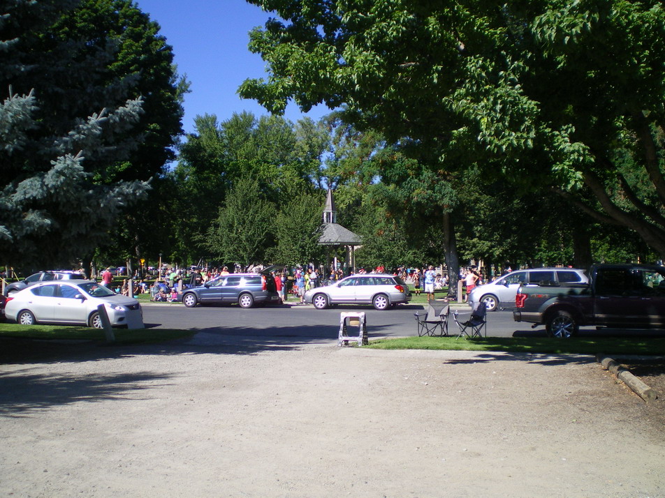
(b) The crowd in a municipal park in Baker City awaits the total spectacle, many using their eclipse glasses. I was thinking of going around the park selling eclipse crackers and eclipse corn chips.