

wxsniss
-
Posts
5,812 -
Joined
-
Last visited
Content Type
Profiles
Blogs
Forums
American Weather
Media Demo
Store
Gallery
Everything posted by wxsniss
-
Changed over to mostly snow in Brookline, ok dendrites. 15z HRRR says we have maybe 2 hours to get a coat-1" lol Unreal winters continue. We had ~4 hours of magic on Jan 7. Maybe it's just me, but the disappointment stings even more when the lay public mocks the field/science (and hobby) of meteorology after such a forecasting debacle.
-
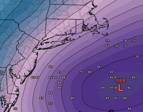
Box from earlier this morning, still expected snow even to Logan: 8:30 AM Update: It is apparent that snow moved in faster than all models had predicted this morning with portions of interior Connecticut well overperforming compared to previous forecasts (several reports of 7"+ have were received prior to 8 AM out of Hartford County). With temperatures above freezing in the Boston Metro area, we have yet to see a change to snow in the city as well as along the immediate coastline. Temperatures should cool over the next couple of hours allowing precip to switch to snow even at the airport in Winthrop, but delays in the changeover will impact how much snow accumulates in the city. As for timing, a changeover should occur by 16Z for any ares still experiencing rain. Dendrites are quite large with this system which will contribute to some rapid accumulations. Some observers have reported inch per hour rates over the last hour or two
-
Plain rain, 36/33 in Coolidge Corner Best soundings in Boston metro were 15z-21z, and best radar returns of event so far are overhead, but not even flakes mixing in. Temps look like CF wrapped around city between 128-495. 717 day record will hold. Can’t believe snow emergency and region-wide school cancellations were called so early on Monday Congrats to folks in CT
-
Congrats!!!! Agree radar looking better than the mesos had us thinking last evening
-
Great band setting up now across CT matches 700mb fronto, can see it on 6z NAM Will tick slowly northeast by 12z
-
6z 12kNAM qpf below, shifted ~25 miles north Decent dynamics and colder 15z-18z Near Plymouth at 18z:
-
Sizable tick north on 6z NAM
-
Yeah you might be right I'm not sure... the most intense echoes do look narrow and stationary, but surrounding echoes less so and are moving northeast. In any case, this feels like microdissecting radar hallucinations, but whether or not echoes hit a wall at ~Susquehanna county in northeast PA (HRRRs) or actually reach the northern PA-NY border (GFS) in the next 5 hours will be telling.
-
@NotSureWeatherpointed this out: Convection (circled below) not really on any models for Tues 6z... up against the northwest wall of dry air, and models have it dissipate as low transfers off Delmarva, but hopefully this translates at least to CT folks
-
Tomorrow will be 717 days and counting for KBOS ≥ 4"... if we don't end the streak before December 2024, we will be at 1000 days... completely off the charts for records since 1891.
-
Funny Maybe this was meant to provoke for fun, but worth saying anyway: ORH_wxman is by far one of the most knowledgeable, accurate, level-headed, and valuable posters on this forum. Perhaps you can teach people here something: what distinguishes a phasing energy from a kicker, and why in this case did the northern stream energy transition from the former to the latter on guidance?
-
https://weather.cod.edu/satrad/?parms=subregional-OH_RV-comp_radar-24-0-100-1&checked=map&colorbar=undefined
-
also "Rollo Tomasi"... felt like one of my closest friends that I've never met in real life
-
Definitely not the debacle that UK/Euro were earlier for inside 495 and southeast... H7 low in a decent spot. As Tip said, from the lay public's perspective, at least would look like a snow storm for a while justifying all the closings. Though I'm not at all confident this is the final outcome. 18z GFS H7:
-
Nauseating And had some high stakes decisions about tomorrow based on American guidance as well (12k/3kNAM, GFS, HREF) and considering that 12z NAM/GFS even ticked better than 6z runs Happens to be American vs. foreign models (Euro, UK, Canadians) I had pointed out last night about this chasing convection on the 0z Euro, but gives pause seeing it double down on that UA analysis will be informative later this afternoon to see if this shortwave energy trajectory is more east vs. northeast
-
For a change, we've had a comfortable buffer with this one (pike region). Much more impactful shift for those on margins: Philly went from 1" at 12z to 11" at 0z. H5 looks about same, but the shift begins to appear at 30h (6z Tues) when the shortwave takes a more easterly than northeasterly trajectory. Confluence is a bit stronger but I'm not certain that's the biggest cause that early. In any case, south is the theme tonight, but as you say I wouldn't be shocked to see this tick north tomorrow.
-
18z GFS adds to strong consensus for intense CCB ≥1-2"/hr snows 15z-18z eSNE, should be a wild morning
-
Crushing at 15z KBOS on 12z NAM and 18z 3kNAM (tossing 18z NAM... looks like may chased some convection?)
-
0z Euro very close to 12z except maybe moves out a hair faster so not as gangbuster closing in eSNE Intense CCB 12z-18z Tues Amazing how stable Euro/GFS guidance has been relative to rest of season Very high confidence for 6-12" across most of SNE, spots 10-14", maybe even spots 14-18" with ratios and steep fronto Huge factors for eSNE are (1) how quickly temps cool, as currently shown start of in low-mid 30s for a few hours, and (2) any bit of capture prolonging this even 2-3 more hours will translate to additional ~3-6" at those rates
-
The "shoot the moon" side of me, given this winter, is rooting for <4" at Logan to ensure our ongoing record (715 days?) is insurmountable for generations
-
Actually a tick north + a bit warmer to start at Tues 12z + wetter... ie., Euro converging with GFS All reflective of slightly more NS interaction you can see even at 60 hrs... and honestly can't rule out even more Verbatim quick crushing for most of SNE into sNH, 6-12" with maybe 10-14" jacks ~ central-northeast CT to northeast MA... Boston metro 4-8"/6-10" depending on surface temps to start Euro / GFS vs. JV models at this point
-
For this season, we're not used to seeing such concordance and stability of guidance at 96 hours. Really only GGEM / UK are off but slowly coming around. And decent buffer for pike region up to NH.
-
Nice to see relative stability for once this winter... Euro is now 24 hours of runs showing 6-12+ for SNE Factors favoring positive busts include better fronto pressed against the cold, and maybe a bit more / earlier NS infusion especially for areas further north like MA/NH border into CNE (though that interaction could also keep the SS more disjointed as in yesterday GGEM runs) Factors favoring tempering expectations include exit speed of system and warm surface temps at least at first few hours in coastal areas
-
Ensembles a hair southeast as well, good place to sit for SNE at this point There's almost 3 apparent clusters... not surprisingly with the cluster near the BM having the deepest systems
-
Yeah this evening's trends of greater confluence continues Just a hint of what Will described of the GGEM... an "almost phase" interaction with NS, but fortunately does not shear it out like GGEM and still have a very potent system... 6-12" towards seasonal redemption across much of SNE SoP. Still a ways to go...

