

wxsniss
-
Posts
5,812 -
Joined
-
Last visited
Content Type
Profiles
Blogs
Forums
American Weather
Media Demo
Store
Gallery
Everything posted by wxsniss
-
Things I'm seeing that improved this Euro run: more shortwave energy overall + slower lead wave + faster trailing wave allowing more interaction Great to see to buck the GFS trends!
-
Holy cow... one of the better runs yet for SNE... 12z Sun (hour 108):
-
Good disco all. Agree with too many middling chefs being a key impediment and setting a 4-8" ceiling. And not much CCB has chance to develop early enough as we saw in the bigger runs earlier today. Quick glance at 12z vs 18z GFS, why the jump? Was wondering if it was different intensity vorticity depicted early in the run and/or a more destructive interaction? I'm still not sure, but you can see differences already at 72hr 12z vs. 66hr 18z on shortwave energy in western Texas. Let's see shortly if that is an early prognostic at 60hr 0z. In any case, doubt we have much certainty before Wednesday PM / Thursday AM.
-
Agree, I'd fly in a heartbeat. Eagle Pass is a great call, 4m 23.6s totality. I'm sure you've seen this: https://www.chooseeaglepass.com/eclipse But with a 1- and 4-year-old in tow, my wife and I thought a 4-5 hour drive from home might be easier and more flexible. The 2017 Gallatin TN event you found was incredible. While we found an isolated grass field inside the venue, hearing the shrieks and wave of amazement sweep through the crowds nearby added to the thrill.
-
Beyond profound is a great way to put it... can't think of anything else that is so out of the ordinary, so directly experienced, and so quickly reminds us how small we really are. For anyone here who hasn't seen one, don't extrapolate from partial eclipses... 99% and 100% are a completely different experience.
-
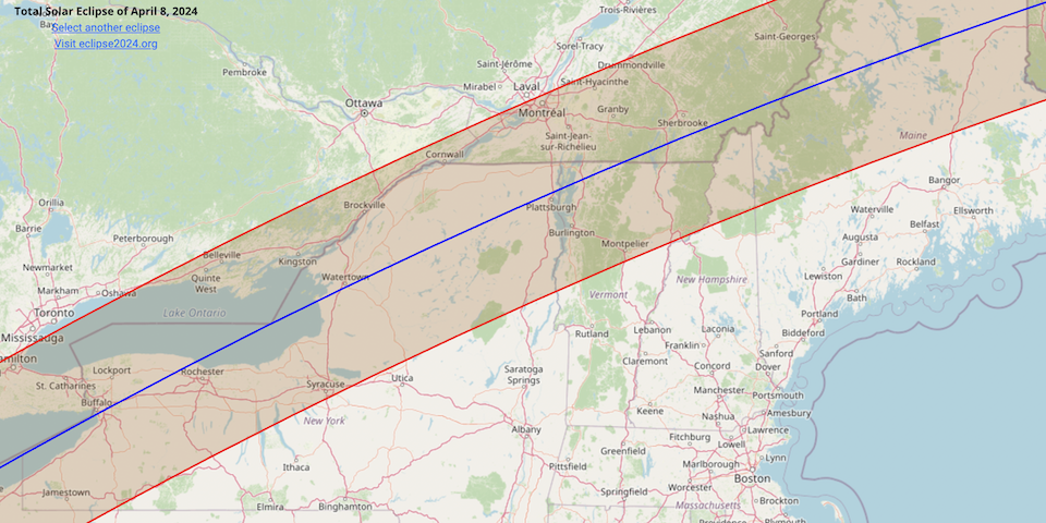
Happy holidays everyone! Thought I'd start a thread to consolidate any trip suggestions / associated weather discussions / obs related to the April 8, 2024 total solar eclipse. Months in advance may seem silly, but some viewing options might take advance planning. With 2 toddlers, I thought a drive somewhere NNE would be easier than a flight. I flew to Nashville, Tennessee to see the 2017 total eclipse. Easily one of the most breathtaking natural events I've ever experienced. Thanks to a tip by @weathafella, we drove to Gallatin where there was a huge free eclipse event of thousands from all over the world, live music, open unobstructed fields, and ~2 min 40 seconds of awe. The next total solar eclipse over contiguous US will be in 2044, so this may be a once-in-a-lifetime opportunity for many. Totality will cross NNE ~3:20-3:30pm Monday April 8 depending on location. Anyone know of any events or planning to drive somewhere in NNE? Links / Info: NASA Map 2024 Total Eclipse Eclipse Simulator Map Location Partial Begins Totality Begins Maximum Totality Ends Partial Ends Dallas, Texas 12:23 p.m. CDT 1:40 p.m. CDT 1:42 p.m. CDT 1:44 p.m. CDT 3:02 p.m. CDT Idabel, Oklahoma 12:28 p.m. CDT 1:45 p.m. CDT 1:47 p.m. CDT 1:49 p.m. CDT 3:06 p.m. CDT Little Rock, Arkansas 12:33 p.m. CDT 1:51 p.m. CDT 1:52 p.m. CDT 1:54 p.m. CDT 3:11 p.m. CDT Poplar Bluff, Missouri 12:39 p.m. CDT 1:56 p.m. CDT 1:56 p.m. CDT 2:00 p.m. CDT 3:15 p.m. CDT Paducah, Kentucky 12:42 p.m. CDT 2:00 p.m. CDT 2:01 p.m. CDT 2:02 p.m. CDT 3:18 p.m. CDT Evansville, Indiana 12:45 p.m. CDT 2:02 p.m. CDT 2:04 p.m. CDT 2:05 p.m. CDT 3:20 p.m. CDT Cleveland, Ohio 1:59 p.m. EDT 3:13 p.m. EDT 3:15 p.m. EDT 3:17 p.m. EDT 4:29 p.m. EDT Erie, Pennsylvania 2:02 p.m. EDT 3:16 p.m. EDT 3:18 p.m. EDT 3:20 p.m. EDT 4:30 p.m. EDT Buffalo, New York 2:04 p.m. EDT 3:18 p.m. EDT 3:20 p.m. EDT 3:22 p.m. EDT 4:32 p.m. EDT Burlington, Vermont 2:14 p.m. EDT 3:26 p.m. EDT 3:27 p.m. EDT 3:29 p.m. EDT 4:37 p.m. EDT Lancaster, New Hampshire 2:16 p.m. EDT 3:27 p.m. EDT 3:29 p.m. EDT 3:30 p.m. EDT 4:38 p.m. EDT Caribou, Maine 2:22 p.m. EDT 3:32 p.m. EDT 3:33 p.m. EDT 3:34 p.m. EDT 4:40 p.m. EDT
-
Agree. But in fact this was several days across multiple models (alternately GFS and Euro, and their ensembles) variably showing a track inside of 100 miles from Cape. NHC did a good job with this. The mode of guidance tracks (which was on left edge of cone for several days) never changed their mean.
-
Yeah you were solid with this. I think I opened with a 10% chance of SNE landfall last weekend iirc, but the trends of the past 2 days made me nervous (of home damage, not of being wrong!) Surf will be spectacular regardless. Hoping for sake of Maine and NS that this could tick even further east.
-
Kudos to NHC for not flinching with the cone... there was a period yesterday when most ensembles and op runs and their trends were on the very left edge of their cone. Some mets (Dave Esptein most prominently) flinched. Still significant lead time remaining in the scheme of tropical forecasting, and we've seen day-of 50-100 mile wobbles happen with majors, but what was always the most likely "correction vector" east is now increasingly supported by guidance today. Hurricane models performed well. Euro / GFS debates? They swapped roles in the closest tracks at various times, so I'm not convinced one was truly better than the other. In the camp of "I awe at severe like everyone on this forum but I don't want actual damage to my house", I'm relieved.
-
0z EPS ticked west compared to 12z Mean is spot on with EC, a bit west of (and slower than) GFS Rare members making landfall into RI / southeast MA / outer Cape... would be bad scenario for Cape / Islands at least
-
Looks like first trough is faster to exit and upstream trough is deeper. Closest approach since Sat 12z run. Outer Cape would get clobbered. Makes landfall ~Portland-Brunswick ME then buzzsaws ME coast
-
Increasing support for the trough interaction tugging this northwest Actually very good consensus between 0z Euro and GFS... tracks 50-100 miles off outer Cape, landfall in Bay of Fundy Looks like maybe 1 member of 0z GEFS is OTS, the rest landfall mostly in Maine or Canada Actually expected more media hype about this by now 0z Euro:
-
Lurking since winter, this one drawing me out... I'm loving the suspense, but I share a bit of nervousness. Funny how being a new homeowner with toddler+baby in the house changes perspective on things... years ago I'd be debating whether I drive to Buzzards Bay or Cape. My gut atm says ~5% SNE / 40% Maine/Canada / 55% OTS. But I could see guidance make an abrupt jump like the 12z Euro, contingent on slower timing and trough interaction... sort of reflected in the 2 GEFS clusters at 18z.
-
Ugh!!! Even more reason to be disgusted by this winter. Hope she recovers quickly. And regarding the latter... I'm sure most members of this forum have experienced the shame of --- after days of scrutinizing guidance and applying meteorology experience --- being wrong to someone who has zero awareness of the complexity. I already heard today "why do these weather people get paid". Infuriating!
-
I believe it! The delta is ~200 feet elevation and a few more miles inland, almost always helps. I was confident in widespread 3-6" for areas inside 128 away from the water... significantly tempered from the potential signaled over the weekend, and even that failed. That persistent appendage low over southern CT --- for resisting cooling of the BL initially that slowed our changeover when we were supposed to be pounding 18z, and for delaying the low consolidation and clean CCB for Tuesday evening, and for maybe fuji'ing the ocean low a little too far north for us --- was a major culprit. Honestly, even 1 hour of >1"/hr rates of actual accumulating snow, not white rain, would have given this some redemption. Add to that the embarrassment of being wrong to relatives/coworkers who had the confident simple skepticism "it's too warm". Hope the wife's ok!
-
Decent bands rotating through Boston metro, but little on the ground to show for it. NWS call would have verified if it were 1-2F colder in BL. This storm had a list of reasons it would disappoint in eastern SNE, but lack of antecedent cold or a cold source has gotta be at the very top. With the exception of that 2/23 snow, recurring theme all winter.
-
Just some bad luck for Boston metro at the moment between the bands but that KLWM-KORH-KBDL band is regenerating and rotating in... I think we at least whiten in the next few hours. Sunset will help.
-
Nothing that hasn't already been said here... but echoes that there remains potential for a few inches in eastern SNE tonight: Quite an impressive storm which will pinwheel westward toward the eastern MA coast this evening then loop southward before pulling away overnight. Dry slot which has impacted areas south of the Mass Pike will fill in through the afternoon as DGZ becomes saturated with increasing lift leading to another pulse of heavier snow across SNE. The focus for the heaviest snow through the early evening will be across N/NE MA as strong NE low level jet from the Gulf of Maine rotates toward NE MA. While temps are slightly above freezing, the heavier snowfall rates are allowing snow to accumulate. Coupled with the strong winds that will develop, very hazardous driving conditions expected in NE MA with some power outages. The challenge into this evening is snowfall accum across RI and SE MA. Initially, will not get much accum from melting but as precip rates increase and temps drop as we approach sunset, expect accum to commence and expect some hazardous conditions on untreated roads. We opted to keep the winter headlines as is. While some areas in eastern MA will fall short of criteria, the combination of wind, snow and reduced vsbys will result in enough impacts. Expect 6-8 inches accum across interior NE MA, decreasing to 3-6 inches along I-95 corridor from BOS to northern RI into NE CT, and 1-3" along and south of PVD-TAN-PWM corridor. The snow will begin to lessen in intensity between 8 pm and midnight as dry slot rotates around the mid level low, but probably not end until late tonight in eastern MA.
-
Skepticism completely warranted. Radar is disjointed at the moment. We're counting on the low retrograding to get some better rates before it occludes... light-moderate won't do anything with these temps. We'll see. I'm hoping for at least a whitened ground.
-
12z Euro says still chance of whitening coast, maybe a sloppy few inches 3pm-11pm, temps never really get below freezing
-
Frustrating morning relative to expectations last night. Heavy rates following changeover stay in northern portion of 495-128. Fwiw, definitive changeover was generally progged for 18z. HRRR/RAP have bands becoming more meridional and pivoting southeast this afternoon, but not sure about intensity.
-
I'm in Fenway area so can't validate the Corey Hill obs... Heavy white rain Wundermap has had a good handle of line that corresponds well to temps:
-
The last hurrah? Putting all the eggs in the Tuesday 3/14 basket
wxsniss replied to Ginx snewx's topic in New England
Best gameplan imo. Unanimous 0z suite so far (not counting some RAPs and HRRRs) that (1) loop track remains offshore, (2) 925s cool to support snow by ~11a-1p, and (3) we get buzzsawed by the CCB for 6+ hours. Euro will me-too in an hour (18z sort of already did). This is looking much better for us than it did early Monday, with some room to improve even more! -
The last hurrah? Putting all the eggs in the Tuesday 3/14 basket
wxsniss replied to Ginx snewx's topic in New England
At what point does BOX upgrade the advisories to WSWs... NAM, GFS, RGEM all now reach warning or more in Boston metro -
The last hurrah? Putting all the eggs in the Tuesday 3/14 basket
wxsniss replied to Ginx snewx's topic in New England
One of the worst handled storms I can remember... major impactful changes within 24 hours on all guidance
