wxsniss
Members-
Posts
5,788 -
Joined
-
Last visited
Content Type
Profiles
Blogs
Forums
American Weather
Media Demo
Store
Gallery
Everything posted by wxsniss
-
Just tuning back... everyone in bed, back to storm! HREF really impressive, even mean snowfall. Anyone know if HREF thermals and/or snow algorithms are less reliable? I ask because mean QPF is very close to NAM, yet HREF has most of ESNE 12-18 mean snowfall. I do remember clinging to HREF snowfalls that never materialized in past storms, other storms it was pretty accurate. Warmest mean 2m Temps at 9z Sun: Snow and QPF are not strictly 10:1 so their algorithm / thermals must be more generous than NAM: Left: Snowfall, yellow = 12-15, orange 15-18 Right: QPF, light blue 1.2-1.5, purple 1.5-1.75
-
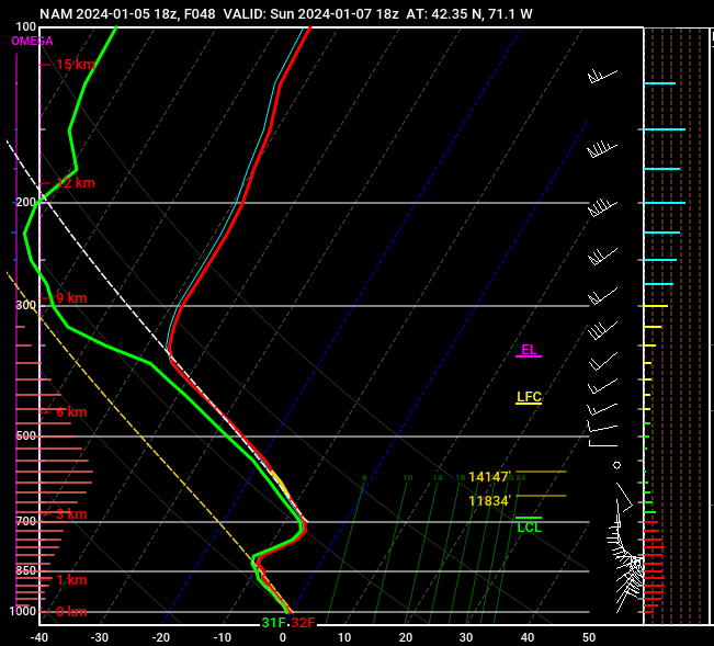
2 wrinkles a little more prominent on this 6z NAM, and I’m thankful we don’t have more time for these to create even more forecasting havoc: 1) interaction of our trailing shortwave with the shortwaves diving down the Midwest 2) convection out east / multi-low structure robbing some of the inflow mechanics… you can see a bit of that hr 51
-
Thanks for updates fellas, haven't had a chance myself to look at any H5 trends... Seems solutions have stabilized away from the north tics earlier today and all give ESNE at least some CCB treatment, widespread SNE 6-12" Critical window and probably last opportunity for drastic changes would be 6z-12z guidance as shortwave energy enters BC ~6z Friday I'll be back for Euro NWS ticked a bit up at coast on 7pm update:
-
Hastily catching up on guidance since this morning, sorry if I missed similar posts earlier. Great post. First energy entered CA ~0z last night. This second piece looks to enter BC ~6z Friday. We've seen today how sensitive outcomes are to strength of these 2 pieces and timing of interaction. Would not be surprised to see continued volatility in guidance next 24 hours.
-
Maybe the biggest change on this 0z vs. 12z Euro run is lead wave seems to move faster... vortmax is ~100-150 miles further east by 0z Sunday. And so the surface low is east. For example, 18z Sunday, ~50 miles east instead of over Nantucket. I don't think we have enough to call this a definitive trend vs. impactful wobbles.
-
This run also a tick warmer at 925 especially east... Agree 4-10" is a safe range this far ahead for much of eSNE. Still think there is a shot at >10" somewhere 128-495 or interior southeast depending on timing of interaction. But we need to see more support for that tomorrow, otherwise today's most bullish runs were a flash in the pan.
-
Definite step back from 12z Euro... interaction with trailing energy occurred too late But, we at least appear to be stabilizing the floor of a solid region-wide warning event, which appears on all guidance. The double-digit ceiling is critically dependent on that infusion of trailing wave, and on this 0z Euro the lead wave scoots east / that interaction is delayed. This will fluctuate and definitely still on the table. Ironic that GFS is now the most robust (at least for SNE).
-
Yeah pieces look perfectly positioned on that 84h NAM for injection of the trailing vort and capture for a big hit eSNE. That scenario is shown on most global guidance at this point. The main mitigating factor on current guidance is if it happens too late... 6z GFS is a good example where the trailing energy arrives too late and the system bombs out too far east
-
Some #s from 12z GFS... this is warmest point 90hr for KBOS... I don't think easterly fetch is strong or prolonged enough to spoil this... when we've struggled in the past we were kissing 0C 950 Station: KBOS Latitude: 42.37 Longitude: -71.02 Elevation: 47.82 Press Height Temp Dewpt Dir Spd SFC 1010.3 48 0.8 -0.3 72 14 M 1000.0 130 -0.1 -1.1 74 20 S 950.0 539 -2.8 -3.0 79 29 S 900.0 965 -5.6 -5.8 88 32 M 850.0 1411 -7.7 -8.1 108 25 S 800.0 1882 -8.2 -13.4 130 14 S 750.0 2383 -7.9 -8.5 182 17 M 700.0 2922 -7.1 -7.7 209 22
-
Growing confidence from EPS/Euro we see double digits somewhere in SNE, finally get this monkey off our back... Pike vs. NE MA vs. NH-MA border vs. SE MA jack tbd, but outside 128 belt Foxboro to Fitchburg looks great atm Opening bid from NWS... seems they are heavily factoring marine influence... the low-res Euro soundings are plenty cold 925 on up, so probably see that gradient closer to coast:
-
Sweet spot for SNE that we discussed on 0z Euro last night: lead shortwave stronger but slightly more delayed, while not strong enough to push baroclinic zone too far southeast + trailing shortwave a tick faster so more likely to invigorate a parting CCB... if all this holds, that last component could push parts of E/SE SNE to 5-10 or more Great to see 12z GFS trending towards this


