michsnowfreak
-
Posts
17,980 -
Joined
-
Last visited
Content Type
Profiles
Blogs
Forums
American Weather
Media Demo
Store
Gallery
Everything posted by michsnowfreak
-

Cure my SE trend hangover event 2/21-2/22
michsnowfreak replied to Baum's topic in Lakes/Ohio Valley
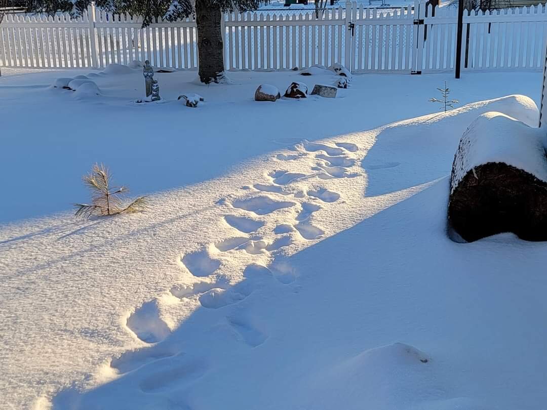
Actually not as much as I thought. I ventured into areas in the cabins backyard and took tons of measurements and it was 23-26" before the last 5" of snow fell. Also took measurements in munising by the Falls yesterday around 4pm and it was 24-27". And I may have went into the ground because I had mud on the bottom 1.5 of my snow stick lol. I have to accuse the munising observer of slant sticking . There's no way the DEPTH of undisturbed snow was 3 feet before this storm, definitely closer to 2 feet. However if the guy lives in a residential neighborhood can't say he has a choice because literally all the snow is layer upon layer upon layer of plowed shoveled and blown snow. With this fresh snow blanketing everything the beauty is indescribable. Will post pics later. -
Doesn't look like anything special but should be at least a few cold inches of powder to come home to. Looks like just piles left at home but fortunately haven't seen a full day of bare ground since mid to late Jan, and haven't seen a day without at least snow piles around since Dec 26. No complaints about the Nov Jan Feb portion of this winter, just Dec.
-
Grand Forks has done fine snow wise, but areas of the Dakotas have had VERY LITTLE snow this season. Many winters there are parts of the northern plains that are a barren wasteland of bitter cold and little to no snow. Many below zero days that don't count as winter days on your formula beavis (cold + however many inches of snowcover). The UP along Superior is where it's at.
-
Cure my SE trend hangover event 2/21-2/22
michsnowfreak replied to Baum's topic in Lakes/Ohio Valley
Fabulous pics bo. Here in Au Train I'm estimating 9-10" total over the past 48 hours. Came in waves (wave 1+les 3", main wave with killer rates about 5", overnight les 1-2"). It's gorgeous out. -
It's fantastic up here! Just got here last night. Still had full snowcover when i left home, missing the disgusting melt and mild rain and enjoying some cold UP snow. Then come home Friday to fresh snow. Been a fun month!
-
I agree with bo.
-
I did notice that the sun helped melt some of the snow on pavement from the drifting last night despite temperatures in the teens. As soon as the shadows shifted whatever melted instantly refroze. Still looks and feels like deep Winter here however the sun angle is making its presence felt.
-
Cure my SE trend hangover event 2/21-2/22
michsnowfreak replied to Baum's topic in Lakes/Ohio Valley
Looks like a nice long duration snowstorm in the UP. I will be in a cabin in the Hiawatha national forest. That will be my 3rd 6"+ snowstorm in 3 weeks! -
Cure my SE trend hangover event 2/21-2/22
michsnowfreak replied to Baum's topic in Lakes/Ohio Valley
I will be in the UP for this one so should get some snow. -
It slept through the squall line because it was right in the middle of the night lol. I estimated 0.4" of snow for my records but there's literally no way to tell how much fell it was just nothing but 45 to 50 mile per hour winds and drifting.
-
That's a good point about Canton covering a lot of real estate. Is Plymouth/Canton is a very large area. I talked to one of the guys who works at the NWS and he lives in Canton closer to the airport and said he had about 7". Speaking of local screwzones, I've lived in Wyandotte since I was 8 and downriver has really not been much of a screwzone since the 90s/early 00s. I remember quite a few storms back then that screwed us but honestly the past 20 years or so we have easily jackpotted easily as many times as we have been screwed. I worked in Farmington Hills from 2015 to 2020 and I was shocked that they did not get more snow than us as I was expecting. Sometimes they could retain a little better during the thaw. Want a sure bet? The hills of northern Oakland always reigns supreme for Southeast Michigan snow.
-
Wow sorry to hear. I know there was a time nw wayne was between banding but 3"? Does that actually sound legit in your yard? Screw zones always vary year to year, so don't get down on your area....this year it's clearly been you, but doesn't mean that will be the case next year. More often than not it is SE Macomb.
-
I'd say 5-7" was the range for most in the metro area. Less north and west. Really an excellent forecast by DTX. The few 4" reports seem out of place and don't make sense based on other reports. You remember how DTX always includes the lowest reports that don't jive but but not the highest reports (several 8" reports via social media) . I notice other nws include all reports. Finished with 6.8" in Wyandotte, 6.6" DTW. From a storm perspective no complaints here. Both big storms this month hit the metro area hardest (in SE MI). This storm was heart of metro area, last storm was DTW-south. Kohls looks tiny with those piles lol.

-
6.4" here. While it's less in total amount than the 2 part storm of February 2/3 (9.2"), it was a more fierce storm in terms of impact and duration. Beautiful out. Love these type of snow storms with all the blowing snow during a night drive when there's not a lot of people out.

-
The last 24 hours. Long lasting snowpack melts, yard is a pool, rainstorm hits overnight, sleet storm hits during the day, snowstorm rages tonight.
-
Beautiful storm outside. Technically amount wise we will still end up with more from GHD3 down here, but this storm is legit.
-
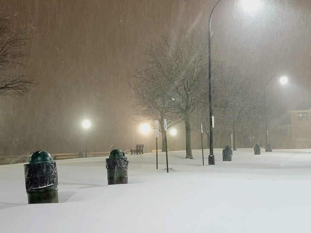
Swirling snow. Beautiful night.
-
What a wild 24 hours. Spiking temps, the long lasting snow pack was wiped out by the 1st real rainstorm since before Christmas. Then plummeting temps after a 1/2 inch assault of sleet and now it's like a blizzard outside.
-
It is not falling apart.
-
Picked up a solid half inch of sleet causing frozen and rutted slippery streets. It has been years since we have had that much sleet (not one of the precip types we often get). Has since turned to snow and it's snowing and blowing nicely. A word of caution, with Grand Rapids radar being down you are going to get what appears to be drying and voids in the radar that are simply not the case.
-
We had freezing drizzle for a while and now it's been sleeting for about an hour. This was totally expected however. Should change over to snow hopefully in an hour or so
-
Only piles and drifts remain. It looks funny to see grass after having snow cover for so long. The rain is moving out. I'm actually happy because a lot of the pooling water was able to soak into the surface of the ground. Obviously the frost depth being 2' the ground is still very frozen but it warmed up enough for the surface to soak up some of that water. Now let's freeze it up and bring on the Winter part of the storm.
-
And that is in just over 3 days time. Sometimes people post op runs for almost 2 weeks later than that lol
-
I remember quite a few from the early 2000s. One of the regions most infamous of course would be January 26, 1967. Record temperatures in the 60s immediately preceded the record storm.
-
It is such a mess outside with the frozen ground and melting snow. There are literally sheets of consolidated ice with water on top of them. We've not had bare ground in about a month and even then the ground was already frozen. I'm really hoping we can avoid the heaviest rain. The one good thing is it does appear to be a break between the rain and the Winter part of the storm as temperatures fall below freezing. By the time the 2nd round of precipitation starts, whether it starts a snow or briefly begins a sleet or freezing rain, temperatures should already be in the 20s.