michsnowfreak
-
Posts
18,382 -
Joined
-
Last visited
Content Type
Profiles
Blogs
Forums
American Weather
Media Demo
Store
Gallery
Everything posted by michsnowfreak
-

Midwest/Ohio Valley/Great Lakes Snow January 24-26
michsnowfreak replied to Baum's topic in Lakes/Ohio Valley
Feb 1965 was definitely a good storm in a fairly boring decade, but I don't get the whole love affair with it from so many people. It dropped 11 to 12" and was fairly long duration. You hear about that more than here about 1974 with almost 20". The 17" storm in 2015 was from a bowling ball type storm though. Maybe that's why those are my favorites. -
Midwest/Ohio Valley/Great Lakes Snow January 24-26
michsnowfreak replied to Baum's topic in Lakes/Ohio Valley
If it stays on track Monroe & Wayne County could easily see more than 5". We got 3.7" yesterday with a few good bands from a much, much weaker system. -
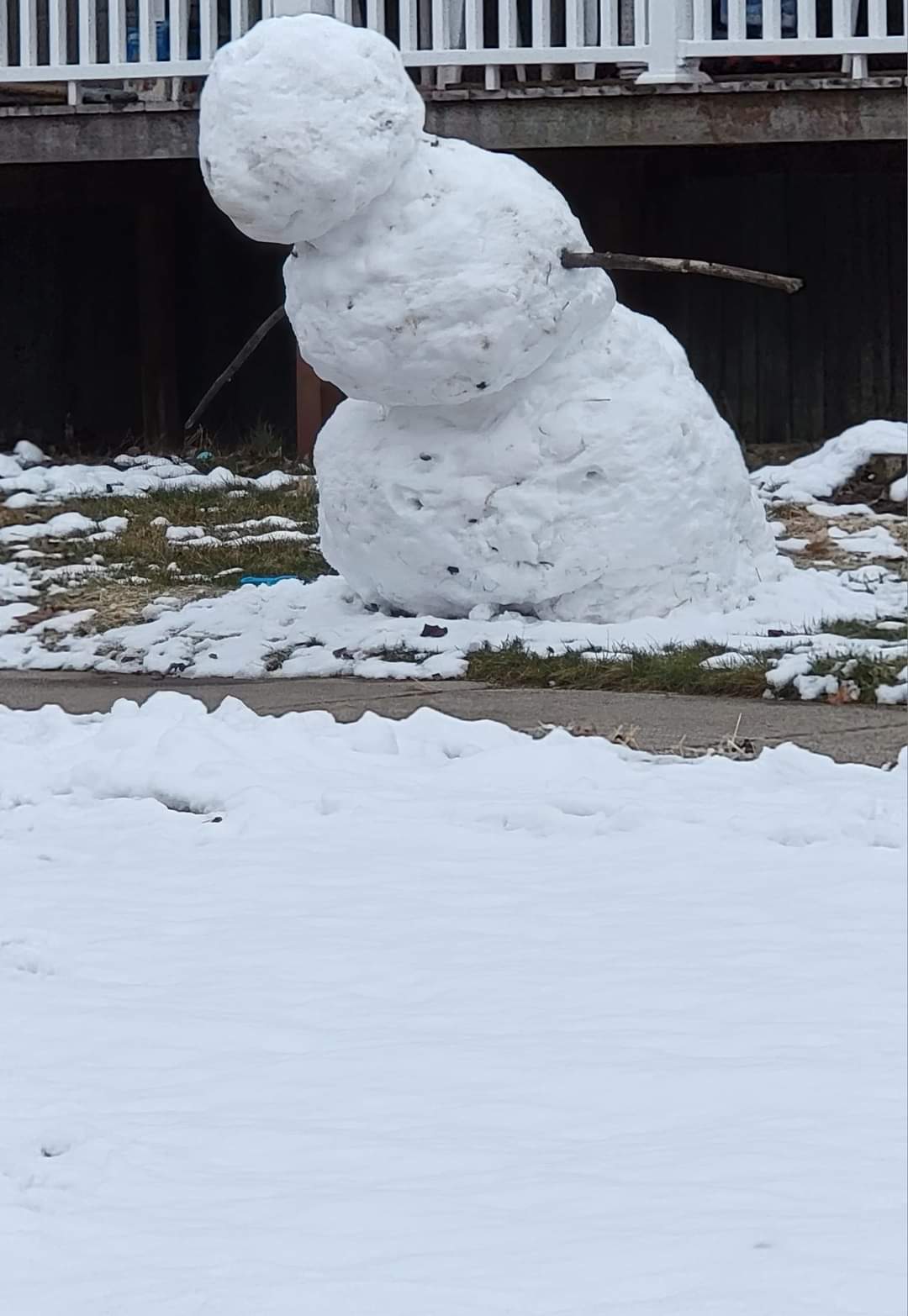
Went to my mom's this evening and noticed that a snowman across the street was bowing down to me.

-
Midwest/Ohio Valley/Great Lakes Snow January 24-26
michsnowfreak replied to Baum's topic in Lakes/Ohio Valley
Total wild card at this point. One thing to keep in mind If we get a good burst and good dendrites it may not matter. Yesterdays snowfall, with temps of 30F-33F the entire time but very good dendrites/rates early on, produced 3.7" snow here on 0.23" liquid. On December 23, we had 2.4" of snow on 0.30" liquid with shredded flakes and temps near 0F. -
The Appetizer: Light Snow general 1-2 " event 1/22-1/23
michsnowfreak replied to Baum's topic in Lakes/Ohio Valley
Of course. It shifts back-and-forth. In the 1990s your area always had more. -
Midwest/Ohio Valley/Great Lakes Snow January 24-26
michsnowfreak replied to Baum's topic in Lakes/Ohio Valley
Looking out my window at a Winter wonderland and seeing heavy snow in the forecast grids for Wednesday. Winter is back! -
The Appetizer: Light Snow general 1-2 " event 1/22-1/23
michsnowfreak replied to Baum's topic in Lakes/Ohio Valley
To be fair even the models had the heaviest snow in the South burbs. But I think we all exceeded expectations with this one. -
The Appetizer: Light Snow general 1-2 " event 1/22-1/23
michsnowfreak replied to Baum's topic in Lakes/Ohio Valley
The snow kept falling and as night approached it started to stick some more so actually ended up with a total fall of 3.6" here bringing season total to 11.7". DTW had 3.3" bringing season total to 11.0". The flurries tonight are adding a sparkle to the dense snow blanket. The scenery was top notch everywhere you looked today. -
The Appetizer: Light Snow general 1-2 " event 1/22-1/23
michsnowfreak replied to Baum's topic in Lakes/Ohio Valley
It didn't melt on contact, it melted a bit as temperatures climbed to 33 and the rates slowed down. What was interesting was that grassy areas the snow really collected well, but on the cement it was much wetter and the shovel and plowpiles look like a super wet snow. Wonderful appetizer, now bring on the main course. Oh and 85 and muggy sounds gross lol. -
The Appetizer: Light Snow general 1-2 " event 1/22-1/23
michsnowfreak replied to Baum's topic in Lakes/Ohio Valley
A little bit of melting here now but the grass tips are still fully covered. We did get the most as expected but it seems like the whole area did better than expected. -
The Appetizer: Light Snow general 1-2 " event 1/22-1/23
michsnowfreak replied to Baum's topic in Lakes/Ohio Valley
Very pleasantly surprised today. I honestly was expecting about 1" of slop instead got an absolutely postcard worthy 3.3" of snow. Sounds like around 2" fell to the North of Detroit but the East and South side had the most due to early banding.
-
The Appetizer: Light Snow general 1-2 " event 1/22-1/23
michsnowfreak replied to Baum's topic in Lakes/Ohio Valley
Less than 2 hours in we already have more than I expected today. Hopefully it's a good sign moving forward! -
The Appetizer: Light Snow general 1-2 " event 1/22-1/23
michsnowfreak replied to Baum's topic in Lakes/Ohio Valley
Waking up to white everywhere is so refreshing. It was 23 days since the landscape was white (despite many days of flurries) and its snowing beautifully. The torturous 3 week stretch is over, I don't know how people in more southern climes do it lol. -
Chicago Weather Records Tracking
michsnowfreak replied to Chicago Storm's topic in Lakes/Ohio Valley
In Detroit, 9 of the top 14 snowiest February's have been in the past 15 years; a trend indeed. -
It was just flurries but I saw them off and on all afternoon.
-
A few interesting tidbits. Yesterday I got 1.30" of rain which was my largest precipitation event since February 17, 2022. That event was mostly frozen, so it was actually my single biggest all rain event since October 25, 2021. Also, hard to believe in this Winter, but today's trace of snow was the 30th day of the season that DTW has had a trace or more of snow.
-
Midwest/Ohio Valley/Great Lakes Snow January 24-26
michsnowfreak replied to Baum's topic in Lakes/Ohio Valley
The GEM and euro ens moved slightly West but not like the op. GFS remained pretty steady. -
Midwest/Ohio Valley/Great Lakes Snow January 24-26
michsnowfreak replied to Baum's topic in Lakes/Ohio Valley
The last 2 Februaries were rocking though. Snow depth was over a foot here in February of 2021. So basically season snowfall the last 2 winters was around average. This year not so much. I do understand the SAD though, lots of people have it with the constant overcast. I don't expect much Sunday but I'm definitely looking at Wednesday with cautious optimism. -
Jan 19-20: Hoosier is not allowed to start this thread
michsnowfreak replied to mimillman's topic in Lakes/Ohio Valley
I don't count the Ts as events either, just thought i would see how many we've had for the heck of it. An average season will probably have around 80 or so once you add up October through April. -
Midwest/Ohio Valley/Great Lakes Snow January 24-26
michsnowfreak replied to Baum's topic in Lakes/Ohio Valley
UHI is typically something that's most pronounced on calm clear nights. I can honestly tell you I have never seen a storm that has solely screwed us because of UHI. Again, track is one thing but I wouldn't worry about UHI. Also, you're fairly new to the area so I don't believe you've experienced some of those Eastside specials that you always lamented while you lived further west. At this point of course nothing to do but watch the model mayhem unfold. -
Midwest/Ohio Valley/Great Lakes Snow January 24-26
michsnowfreak replied to Baum's topic in Lakes/Ohio Valley
Track may screw us, UHI will not. -
Midwest/Ohio Valley/Great Lakes Snow January 24-26
michsnowfreak replied to Baum's topic in Lakes/Ohio Valley
For DTW GHD2 hands down was the winner. GHD1- 10.3" GHD2- 16.7" GHD3- 9.3" -
Jan 19-20: Hoosier is not allowed to start this thread
michsnowfreak replied to mimillman's topic in Lakes/Ohio Valley
Believe it or not there have been 29 days this season with a trace or more of snow at DTW, including 12 days of measurable snow. -
Winter 2022/23 Short/Medium Range Discussion
michsnowfreak replied to Chicago Storm's topic in Lakes/Ohio Valley

-
The surface temps were not a blowtorch tho.