IUsedToHateCold
-
Posts
838 -
Joined
-
Last visited
Content Type
Profiles
Blogs
Forums
American Weather
Media Demo
Store
Gallery
Everything posted by IUsedToHateCold
-

Feb 22nd/23rd "There's no way..." Storm Thread
IUsedToHateCold replied to Maestrobjwa's topic in Mid Atlantic
I knew when it said there 170 responses in 30 minutes that it was a hit, but oh boy. What sacrifices must we offer the King for it to bow to the GFS on this one? -
Late February/Early March 2026 Mid-Long Range
IUsedToHateCold replied to WxUSAF's topic in Mid Atlantic
Have no good reason for it but I feel good about this one. We're still very much in ensemble range and I believe those have been trending in the right direction. Someone correct me if I'm wrong. -
I'll take my 1.8 inches and like it.
-
AI Euro?
-
Since we have no source of cold air, this is one of those times where location/climo is really going to matter. My guess? NW areas are going to do a lot better than SE.
-
I'm not buying the NAM at this range no matter what it says. Euro AIFS says go and it's been deadly this year, so it's go until it says otherwise.
-
42.4, pack still looks pretty good. Some dirt/grass is showing in a few more areas but nonetheless very white.
-
I don't fear the reaper. Bring him in so I can show him a calendar. It may only be a little, but I'd bet it snows here again before the season is out.
-
This throws away too many opportunities though. I was in Bowie in (I think it was 2018) and we got like 6 inches on March 21st or some absurd date like that. Not that we expect snow that late to stick around for awhile, but I argue that tracking season doesn't end until the vernal equinox or so.
-
A few flakes out there, have to squint to see them
-
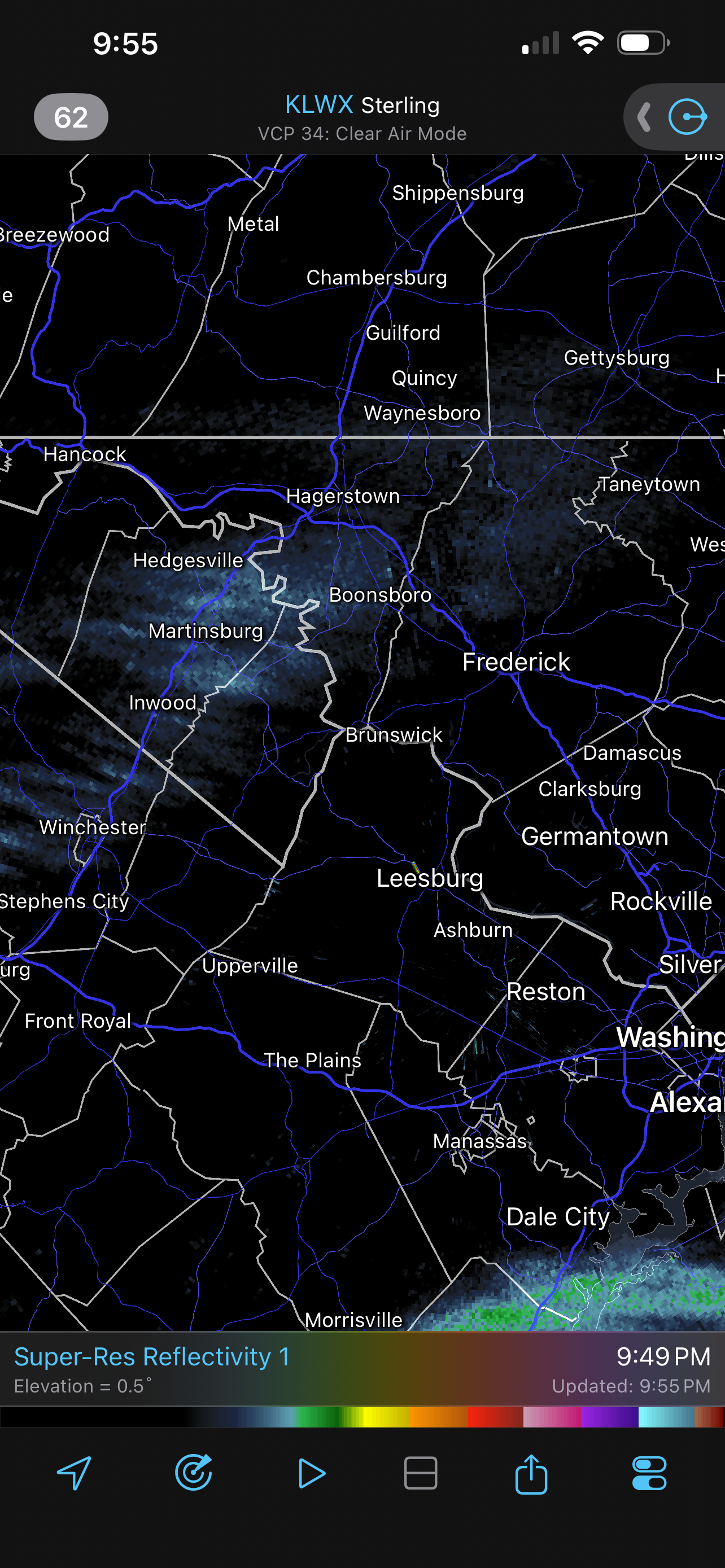
The line of precip out west looks strong enough to make it across the mountains. Been seeing light returns overhead, which is encouraging. No precip, of course. 31.8/10.8
-
I'm at 32.2/13.2 so should wetbulb below freezing
-
The wind always seems to perform. Pretty concerned for my area as BGE has become so unreliable that the power goes out in anything faster than a light breeze. Hope to see measurable snow, won't be surprised if all we get is a few snow squalls.
-
Rain is traumatic right now guys. The pack is so beautiful. Let's just not even talk about it.
-
I had a dream nightmare that it was raining on my snowpack. I woke up to relief when I recalled it was 15 degrees outside.
-
WxUSAF's weak ass frontal passage thing.
IUsedToHateCold replied to dailylurker's topic in Mid Atlantic
Some weak stragglers trying to make the long mountain journey. Maybe I'll make 0.1 inches.
-
WxUSAF's weak ass frontal passage thing.
IUsedToHateCold replied to dailylurker's topic in Mid Atlantic
My high was 41.9 and now down to 37.4 -
WxUSAF's weak ass frontal passage thing.
IUsedToHateCold replied to dailylurker's topic in Mid Atlantic
The pack is indeed being roasted. 40.6 degrees. But like @SnowenOutThere said, hopefully this means a bust in our favor tonight. But who are we kidding? We have the HRRR+GFS prizewinning combo in our corner! This can't end badly. -
35.6. Felt balmy outside. At least we have cloud cover to protect the pack a bit today.
-
WxUSAF's weak ass frontal passage thing.
IUsedToHateCold replied to dailylurker's topic in Mid Atlantic
I will not hug the HRRR. I will not hug the HRRR. I will not hug the HRRR. Honestly have zero expectations for this one. If I see a flake I'll take it as a win. -
35.8, blew away the forecast high of 31. Typical for around here.
-
The “I bring the mojo” Jan 30-Feb 1 potential winter storm
IUsedToHateCold replied to lilj4425's topic in Southeastern States
In all great Northeastern winter storms the eastern coasts flirt with the mix line. Looks like that is happening out near Morehead City. Just north of there (e.g. New Bern) the rates should be incredible right now. -
January 30th- Feb 1st ULL and coastal storm obs
IUsedToHateCold replied to JoshM's topic in Southeastern States
Coastal is just getting underway Eastern NC is going to get hit hard
-
21.7, low of 5.4 - smokin' sunshine while I watch the southerners get crushed or complain about the dry slot. Still looks like a winter wonderland out there, reminds me of the winters growing up in Massachusetts. Good stuff.
-
Better position but worse track. I don't think we're getting anything here, but you know, It's fun to watch I guess?