

Terpeast
-
Posts
6,687 -
Joined
-
Last visited
Content Type
Profiles
Blogs
Forums
American Weather
Media Demo
Store
Gallery
Everything posted by Terpeast
-
One scenario i can see playing out is 2 precip maxes, one along the blue ridge NE into central maryland as the low gets going... and the other that starts E of DC into NYC once the coastal strengthens and 850 low closes off. Maybe the canadian models are latching onto the first precip max and extending it NE while leaving the S & E warmer and wetter, and the colder weaker more S/E solutions are conversely under-doing the NW precip max. As much flak the GFS gets these days, it did pretty well in the short range <48 hr in the last storm IIRC. So now maybe we are starting to get those mesoscale details into better focus where the secondary NW max gets 3-6/4-8+ of powder while the other qpf band along DC-Balt-Philly-NYC gets 3-5" of wet snow. As Chill would say, just spitballing.
-
One of the two model camps is going to cave dramatically. I think I know which to put my money on.
-
Fits with the CWG forecast. Classic fall line
-
I’d take the under on kuchera ratios along i-95 and just NW, but could be right for the elevations. Feeling 2-4” areawide, 3-6+ well nw (cacotins and mount psu, m/d line)
-
Could be why LWX is hedging towards 0 for i-95 on the low end. I'm sure it's automated, but still... I'm not worried though
-
Spun the wheel and got less than last night's dusting. Bah
-
High ratio cold smoke on the gfs. Check the soundings
-
Big difference this time is we’re tracking another potential snow event instead of staring down an 80 degree day in January like last year
-
That is true, but when trying to retain snowcover till the next storm, it is annoying when it shoots up into the 40s. Funny, I didn’t think I’d say this in what looked like an incoming -enso -pdo +qbo torch of a winter where one of the top analogs was 22-23, where we couldn’t even get below freezing half of those nights!
-
It’s not as “locked in” for next week as it had been for Sunday. We have that going for us. Plenty of room for it to trend our way.
-
12/24: 0.1” 1/3: 0.3” 1/6: 7.6” 1/11: 1.3” 1/16: 0.5” Season total: 9.8”
-
Calling it 0.5” and done for the evening. Decent little event.
-
Light snow, 0.4” but not quite done yet. Might pull half an inch as expected, maybe a bit more
-
Looks like models are starting to converge onto a final solution, which might become clearer by Saturday morning.
-
Still coming down. Big flakes. Roads about to cave
-
I’m at 0.3” so far
-
Jebwalked with my daughter, already 0.2” and big flakes coming down. Loving it
-
Finally snowing
-
Still nothing...
-
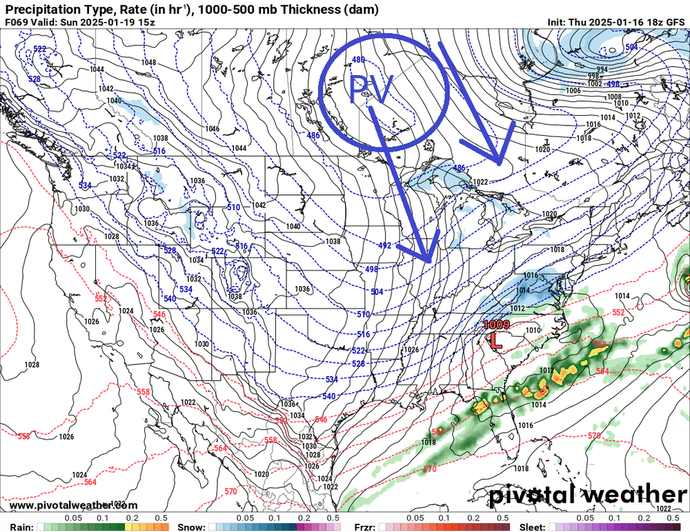
Devil's advocate. One thing that might keep the NW trend to a minimum is the PV pressing SEward and less wave spacing between the sunday system and the preceding low. How far and how strongly the sfc flow is and the PV press is will determine the ultimate track. But if this cold PV is as strong as depicted, I don't think there's a whole lot of room to trend NW.
-
Nothing yet, but hopefully soon
-
That's funny. I gotta wonder though... my ambient station's temp really shoots up whenever the sun comes out, being 2-3 degrees warmer than other stations around me. But at night, it's on par with other stations. Do I need to calibrate it? Or was it just sited poorly?
-
broke freezing, 34.5 for the high
-
Seeing breaks through clouds, up to 31 now. Radar seems to be filling back in to the west.
-
Can anyone post the >3in probability map for EPS just to compare with GEFS?


