Terpeast
-
Posts
6,687 -
Joined
-
Last visited
Content Type
Profiles
Blogs
Forums
American Weather
Media Demo
Store
Gallery
Everything posted by Terpeast
-
1/19 - The Roulette Wheel 29 Black Storm - OBS
Terpeast replied to DDweatherman's topic in Mid Atlantic
Still dropping. 35.6/31.8 -
1/19 - The Roulette Wheel 29 Black Storm - OBS
Terpeast replied to DDweatherman's topic in Mid Atlantic
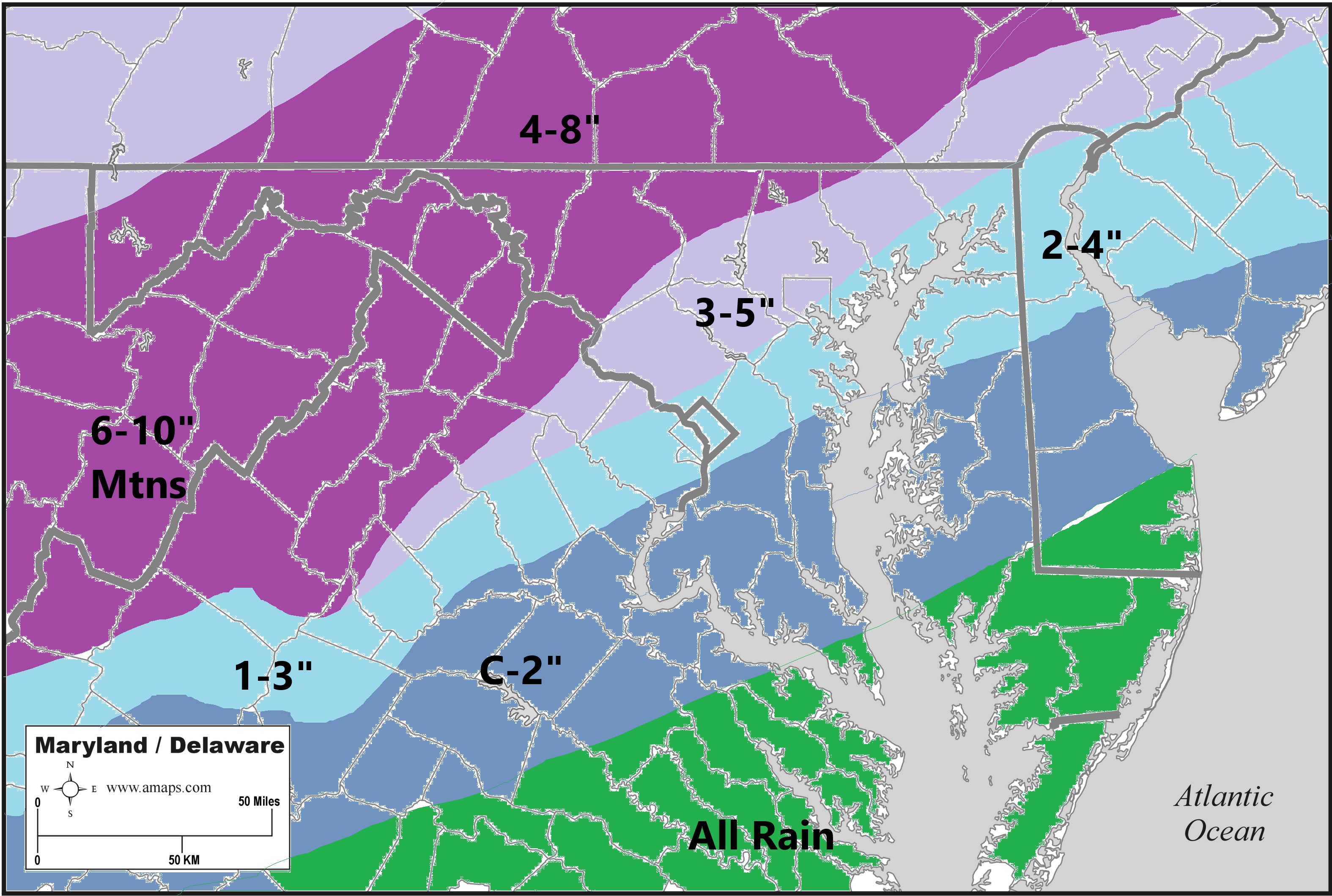
I’m actually thinking 2-4” for you and DC metro because of the potential heavy band once the coastal gets going. But further SW like CHO, I don’t see them getting in said heavy band. Sorry its a bit misleading, my bad ps. Next time I won’t use cyan haha -
1/19 - The Roulette Wheel 29 Black Storm - OBS
Terpeast replied to DDweatherman's topic in Mid Atlantic
Final call (I know, ugly map, but it gets my idea across)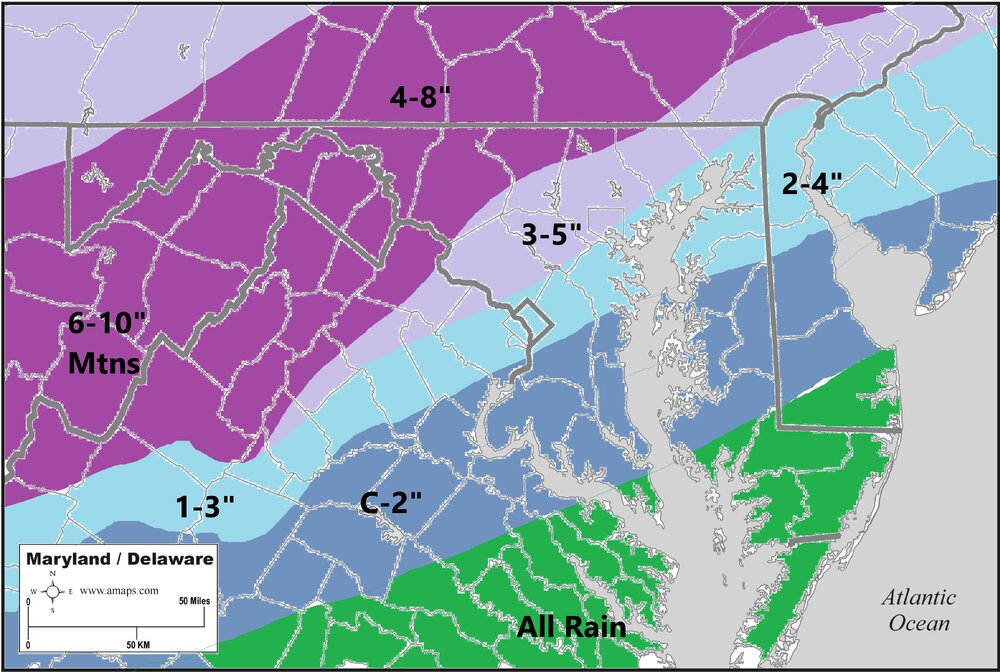
-
1/19 - The Roulette Wheel 29 Black Storm - OBS
Terpeast replied to DDweatherman's topic in Mid Atlantic
Down to 38.8 already. Dews 32.5 -
Well, that is close. So close. Plenty of time to reel this one in, too
-
1/19 - The Roulette Wheel 29 Black Storm - OBS
Terpeast replied to DDweatherman's topic in Mid Atlantic
After posting this, I’m down to 42 -
1/19 - The Roulette Wheel 29 Black Storm - OBS
Terpeast replied to DDweatherman's topic in Mid Atlantic
Mby station is reporting 47.5 as the high, now 47. Under sunny skies. Full two degrees warmer than other obs, so probably 45 is the real temperature. May need to calibrate my station temp… -
1/19 - The Roulette Wheel 29 Black Storm - OBS
Terpeast replied to DDweatherman's topic in Mid Atlantic
I’ll try and hold the line for all of our sakes! -
Living on the fall line your whole life esp your formative years will do that to ya lol
-
Maybe its just me having grown up in Vienna only a few miles out of the beltway, but feeling a little nervous being close to the fall line even in Ashburn
-
Looks like a hold
-
Great sign! Lets see if it shifts one more time to get DC metro in the game for high end advisory!
-
Good observation. It’s the nam, but we’ll see if other models trend that way. It may not take much, maybe 150 miles further N to get DC in the game. 200 for you probably.
-
Does anyone know if the 3k nam has a history of moving frontal boundaries too quickly, or just right?
-
kinda surprised the rgem didn’t cave. Oh well, I rather have the euro on my side than rgem.
-
The pack is gonna take a beating today. It held on strong when wet bulb temps were close to freezing even when air temps were in the 40s, but today is different.
-
So we don’t have to pull an all nighter just to see the snowfall for once, how nice. I like my sleep
-
Would have me beating last winter with two weeks left in January
-
3-5” areawide all the way down to EZF-Calvert-Dover would be a massive win and morale booster
-
Erroneous output, most likely. Not a problem with 3k though. Hopefully they decomm the old nam and keep the 3k
-
3k nam 0.3” qpf area wide
-
If that lead wave over OH speeds up a bit and gives the main wave some breathing room, this could pop something on the surface
-
Well at least won’t melt as soon as the backedge appears on radar because it’ll be cold. Bro.
-
Euro has that dual band structure even with low qpf overall. The NW band will have higher ratios and produce more snowfall than depicted on 10:1 ratio maps.
-
if it makes you feel any better, I might be the one who gets stuck between the two. Especially if the storm shifts more NW than the GFS/NAM are saying