Terpeast
-
Posts
6,687 -
Joined
-
Last visited
Content Type
Profiles
Blogs
Forums
American Weather
Media Demo
Store
Gallery
Everything posted by Terpeast
-
1/19 - The Roulette Wheel 29 Black Storm - OBS
Terpeast replied to DDweatherman's topic in Mid Atlantic
You are at Harpers Ferry? -
1/19 - The Roulette Wheel 29 Black Storm - OBS
Terpeast replied to DDweatherman's topic in Mid Atlantic
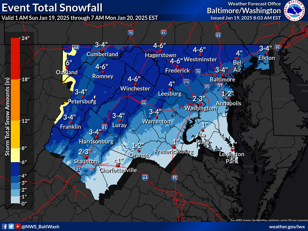
LWX updated forecast as of 8 am
-
1/19 - The Roulette Wheel 29 Black Storm - OBS
Terpeast replied to DDweatherman's topic in Mid Atlantic
It won’t take much. Once the rates come, temps are gonna drop and fast. Entire column is cold enough, except the bottom portion of the boundary layer. May lose just <0.1” qpf because of that, nbd. Just means we probably won’t hit the high end of the forecast -
1/19 - The Roulette Wheel 29 Black Storm - OBS
Terpeast replied to DDweatherman's topic in Mid Atlantic
Rose to 38.5 at 6 am, dropped to 37 since. Radar showing growing precip west of charleston wv - those are the goods to watch. -
1/19 - The Roulette Wheel 29 Black Storm - OBS
Terpeast replied to DDweatherman's topic in Mid Atlantic
I know right? This event hasn’t even started yet and we’re cliff diving. Yes we’re running a bit warm atm but the arctic front is coming and banding will develop along that front. It’ll be a beatdown and how much we get will be determined how long the banding lasts -
1/19 - The Roulette Wheel 29 Black Storm - OBS
Terpeast replied to DDweatherman's topic in Mid Atlantic
Cold air is slower, precip about the same. LWX says precip is faster, but I don’t see that yet. -
1/19 - The Roulette Wheel 29 Black Storm - OBS
Terpeast replied to DDweatherman's topic in Mid Atlantic
I still think we have a shot at 3” or a little more when the arctic front passes with heavy banding along that. -
1/19 - The Roulette Wheel 29 Black Storm - OBS
Terpeast replied to DDweatherman's topic in Mid Atlantic
It would be hilarious if the RGEM had the right original idea -
1/19 - The Roulette Wheel 29 Black Storm - OBS
Terpeast replied to DDweatherman's topic in Mid Atlantic
Not a promising sign for south of i-66/rt 50. North of that should still be on track. Gonna be an interesting afternoon .NEAR TERM /THROUGH TONIGHT/... Model trends early this morning show Arctic front has slowed down considerably since yesterday and is not fcst to clear the northern half of the fcst area until after 18Z. Meanwhile, models trends and microwave imagery through the snowfall rate product show precip arriving sooner than previously expected. Microwave passes since 0220Z showed that snow has been falling in the mountains since that time and a more recent pass from 0800Z showed that snow, at least aloft, has made it to areas just west of I-81. Further east, gridded NUCAPS data showed that 925 and 850 mb 0C isotherms are further north than model guidance suggest and given current temps in the upper 30s and slower trend on the passage of the Arctic front indicate that areas along and south of Interstate 66 and US-50 will see more rain or mixing with rain at the beginning of the precip event. Still, a 3-hr period of intense precip rates is expected this afternoon, mainly between 18-21Z, when Arctic air will be advancing southward. The low pressure system will be out of the picture by 00Z Monday with most of the snow gone, except in far northeast Maryland and in the mountains where snow will continue all night. New snow totals maps were changed slightly, basically to cut down on snow accumulations some, particulary along and south of Interstate 66 and US-50 and precip start time was adjusted to bring precip sooner. -
Pick! Its ovah!!!
-
Now we know what their offseason priorities are. it aint over till its over. Its on the defense now
-
I would have never predicted we’d be up 17 with 8 min left
-
What the what? What JUST happened??
-
1/19 - The Roulette Wheel 29 Black Storm - OBS
Terpeast replied to DDweatherman's topic in Mid Atlantic
35.6 now -
Omg this is crazy
-
So I don’t know what the outcome of this game is going to be, but we just put up 31 points on the best seeded NFC team… in one half… on the ROAD
-
1/19 - The Roulette Wheel 29 Black Storm - OBS
Terpeast replied to DDweatherman's topic in Mid Atlantic
Hopefully this is the halftime adjustment we make -
What a throw!
-
Omg! Pick 6!!!
-
Terry!!!!
-
1/19 - The Roulette Wheel 29 Black Storm - OBS
Terpeast replied to DDweatherman's topic in Mid Atlantic
Mine is 10’ agl but at the bottom of a hill that my house sits on, so my deck is actually higher than the station -
As soon as I saw him start playing, it was like “oh crap, its gonna be a long night”. Beast.
-
1/19 - The Roulette Wheel 29 Black Storm - OBS
Terpeast replied to DDweatherman's topic in Mid Atlantic
And my point n click went from 2-4” to 3-5” -
1/19 - The Roulette Wheel 29 Black Storm - OBS
Terpeast replied to DDweatherman's topic in Mid Atlantic
Hit freezing, then dead cat bounced up to 33/31. Think i’ll hover around there or maybe a couple deg lower through the night until précis starts -
1/19 - The Roulette Wheel 29 Black Storm - OBS
Terpeast replied to DDweatherman's topic in Mid Atlantic
32.9/30.5