

Terpeast
-
Posts
6,591 -
Joined
-
Last visited
Content Type
Profiles
Blogs
Forums
American Weather
Media Demo
Store
Gallery
Everything posted by Terpeast
-
Actually I started at 1962, where IAD data begins. So I'm really starting from one of the coldest (and relatively snowier) periods in the 20th century save for the early 1900s.
-
I know it doesn't feel like it now, but the fact that all the southern areas cashing in at least puts to bed the theory that snowstorm tracks are moving further north and cutting us out. We're still good. If anything, we lost maybe 15-20% of our usual snow climo in the long term. Like Bob Chill, I have a feeling that the next 5-10 winters will be more closer to climo compared to the last 8 years and include at least one big dog, maybe two.
-
The issue was extremely dry air east of the blue ridge and north of 29. Not sure that was foreseen, but I think a lot of precip evaporated before reaching the ground.
-
Light flurries in Ashburn, not much of consequence
-
Nothing falling here. Advisories dropped. It's been a rough stretch since the last snowstorm on Feb 11
-
I wouldn't sleep on the 2/27-28 wave yet. Primary too far NW atm, but with deamp trends...
-
I really think that it could have gone either way... the TPV hanging back west allowing the SS wave to pinwheel north to hit us... OR move further east to phase with the SS wave. Either would have resulted in at least a SECS+/MECS hit. Chalking it up to just bad luck. Cookie crumbled wrong for us. Football bounced the other way.
-
Pixie flurries.
-
Even drier here. Dews at 1. It's so dry my lips are badly chapped and nose is bleeding a bit.
-
Nothing here in ashburn, not surprisingly
-
I have been quite impressed with its verification scores lately, at least under 7 day lead times
-
Really does feel like snow out there. 18 degrees. Woulda been beautiful cold smoke. Better luck next time
-
This falls in line with the next cold window I'm seeing around March 4-10. I think it'll be a shorter window than the models are predicting. Here's hoping we get a well timed wave in that window as a last winter gasp.
-
@mitchnick I think you'll find this interesting: Known AIFS Forecasting Issues - Forecast User - ECMWF Confluence Wiki
-
The deamplification trend is real
-
Yep. Ignorance was bliss. Now it’s like we know too much
-
Sorry if it sounds selfish, but I have an overseas family trip planned next February and I’d be more worried about missing the big one if it were an el nino.
-
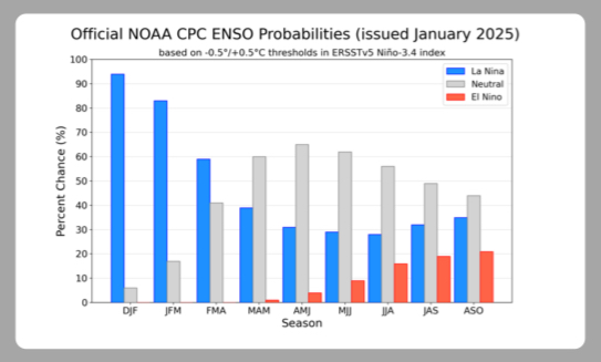
El Nino next winter is not a lock. We’ll know better by summer, but looks neutral maybe nina-ish going into Fall right now
-
Just saw a snow plow drive by. Not sure they got the latest memo
-
I was saying in the other thread about models deserving a poor grade, and if the storms comes back north (unlikely) then that would be an even more damning on the models.
-
I know we’re upset about the modeling fail, and I am too… but objectively, this has been a decent winter south of i-70 especially after going in with -enso/-pdo/+qbo and a high chance of a wall-to-wall torch. I wouldn’t change my grade on this winter even if it ended today. C+/B- imby, B+/A- for the southeast zones who jacked twice in the biggest storms. My grade is based on how much cold we had, how much snow fell, how many “snow days” we had, and how long snow cover lasted. Model performance gets a totally separate grade, and I’m not as generous on that end.
-
Narrator: “Plot twist, there is no storm.”
-
a 50 mile shift is not much at this range and while that is certainly possible even in this case, it’s doubtful given the strong trends the opposite way.
-
NAM caved. It may still show 3-6” here but with the trend that amount will dwindle in the next several runs.
-
Well. That was… exhausting. Need to rest and turn off all screens and devices. I’m out.


