Terpeast
-
Posts
6,615 -
Joined
-
Last visited
Content Type
Profiles
Blogs
Forums
American Weather
Media Demo
Store
Gallery
Everything posted by Terpeast
-
Jan/Early Feb Medium/Long Range Discussion Part 3
Terpeast replied to WinterWxLuvr's topic in Mid Atlantic
Let’s hope this doesn’t get can kicked, we cannot afford that -
Jan/Early Feb Medium/Long Range Discussion Part 3
Terpeast replied to WinterWxLuvr's topic in Mid Atlantic
That’s a big step back from previous runs. Now looking like an interior north hit with rain down here -
Jan/Early Feb Medium/Long Range Discussion Part 3
Terpeast replied to WinterWxLuvr's topic in Mid Atlantic
Looks like a transitional week feb 5-12 (similar to first 10 days of Jan) and then feb 12 and onwards we get our chances i do wish it gets moved up even a few days though, we don’t want this thaw running the clock out on us -
Fell short of freezing. 31.5 for the high, now 30.9
-
Jan/Early Feb Medium/Long Range Discussion Part 3
Terpeast replied to WinterWxLuvr's topic in Mid Atlantic
So this might go in banter or panic room because this is purely unscientific conjecture… But if the pac jet is getting stronger with a hadley cell squeeze no matter in a nina or nino, what should we root for? More ninas where the jet doesn’t get as super extended as in ninos, but still extended enough to stick a pna ridge in the west? Last time we tried that though, we got a +PNA but the downstream trough dug right underneath into baja, and the pna ridge just flopped over right on top of us. Maybe that was just a one off? I know in ninas we get an Aleutian ridge which is usually kiss of death for us, but it shouldnt take much of an extension to push that ridge over the top into AK and drive more cold air down here? It can’t be that hard -
Jan/Early Feb Medium/Long Range Discussion Part 3
Terpeast replied to WinterWxLuvr's topic in Mid Atlantic
For now it’s way too warm, but there’s a cold high lurking to the north. It won’t take much of a favorable trend to flip this into our favor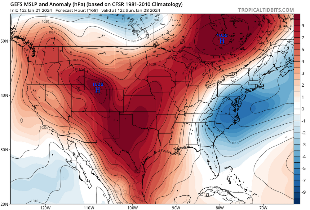

-
Low of 18
-
Jan/Early Feb Medium/Long Range Discussion Part 3
Terpeast replied to WinterWxLuvr's topic in Mid Atlantic
That’s your plan B -
Jan/Early Feb Medium/Long Range Discussion Part 3
Terpeast replied to WinterWxLuvr's topic in Mid Atlantic
Feb 12 2024 book it -
High of 25, now 19
-
Jan/Early Feb Medium/Long Range Discussion Part 3
Terpeast replied to WinterWxLuvr's topic in Mid Atlantic
I know this is in jest, but the period jan 28-31 is one to watch even in a lousy pattern. Going to be a needle threader or late miller B or may just be a perfect track rainstorm, but we’re still in the game. Wouldn’t count us out yet all the way to 2nd week Feb -
Jan/Early Feb Medium/Long Range Discussion Part 3
Terpeast replied to WinterWxLuvr's topic in Mid Atlantic
Agreed. Since I’m exactly halfway to the old climo benchmark, I’d give it a midterm grade of B. -
Jan/Early Feb Medium/Long Range Discussion Part 3
Terpeast replied to WinterWxLuvr's topic in Mid Atlantic
How far out? 8-9 days if I remember correctly? Further back, guidance was showing a torch mid month -
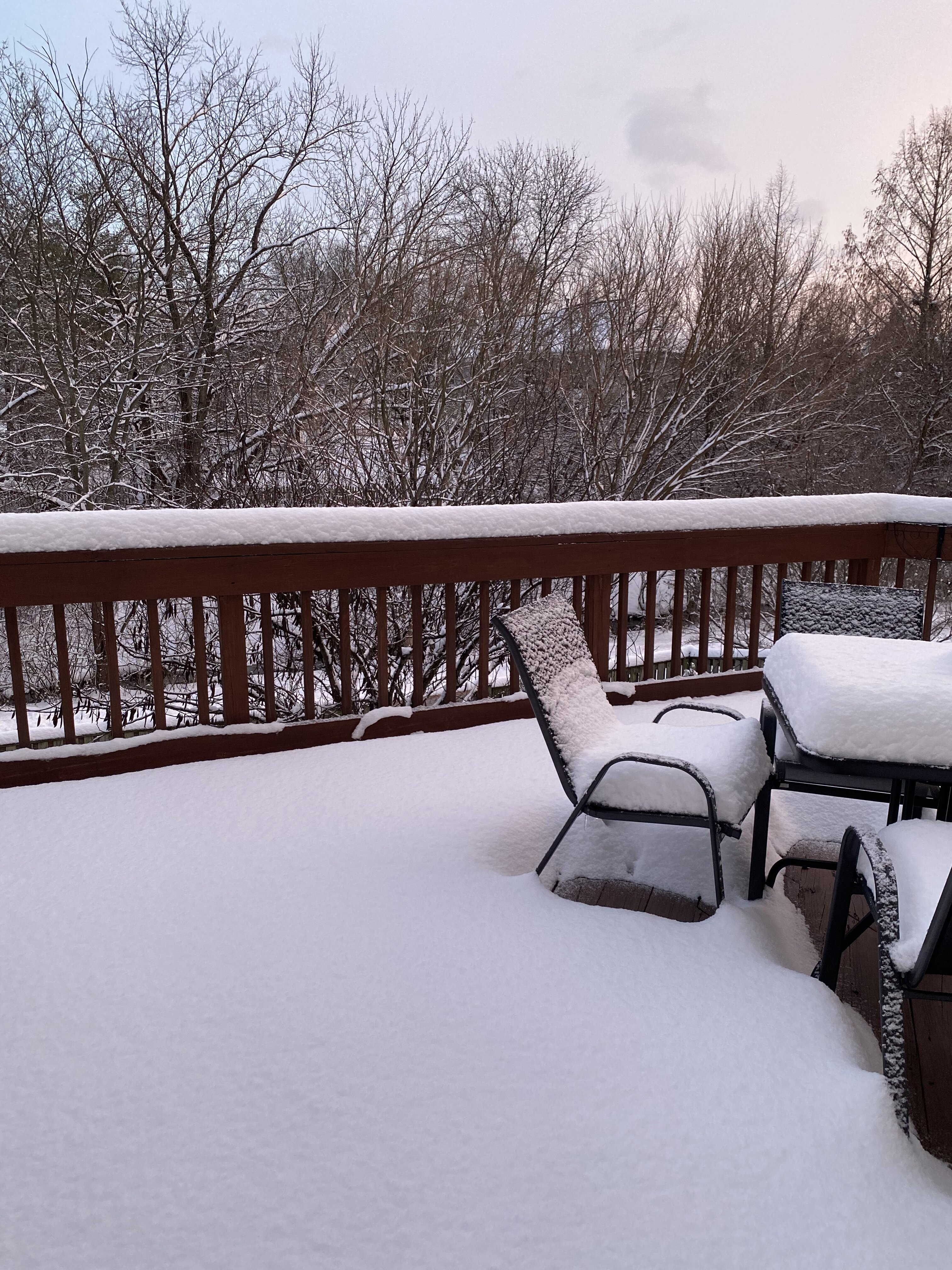
Just went out for a drive. 5-7” snow pack, cold windy blowing snow off roofs, deep winter feel. Soaking it all in before shit the blinds. This is the time to close up your laptops and get the F out there and enjoy winter!
-
Jan/Early Feb Medium/Long Range Discussion Part 3
Terpeast replied to WinterWxLuvr's topic in Mid Atlantic
Same. Maybe not a MECS but something might sneak up on us like this week has -
Mid-Atlantic Snow Totals Thread - Winter 2023-2024
Terpeast replied to mattie g's topic in Mid Atlantic
Boston, too -
Awesome, the mountains are having a great year! When we visited last year, there was only 4-6” on the ground with icy layer underneath, and that was in February!
-
Mid-Atlantic Snow Totals Thread - Winter 2023-2024
Terpeast replied to mattie g's topic in Mid Atlantic
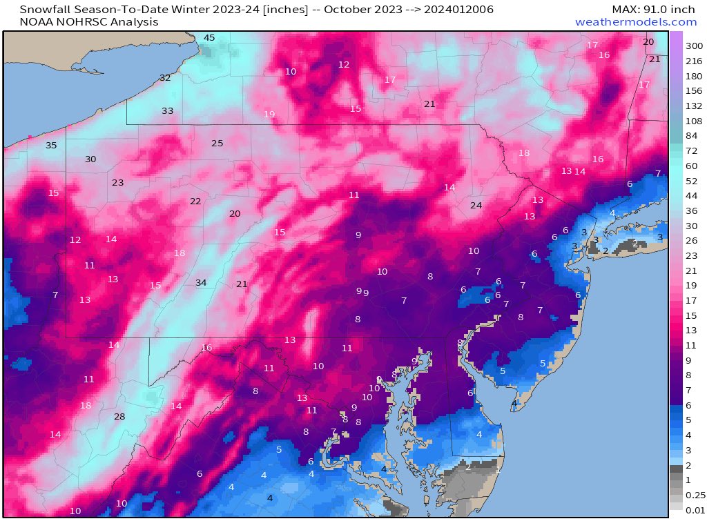
Seasonal snowfall to date. That 11” near my house checks out.
-
Mid-Atlantic Snow Totals Thread - Winter 2023-2024
Terpeast replied to mattie g's topic in Mid Atlantic
I wasn’t in Ashburn at the time, but I don’t think it was anything more than a trace. -
Low of 15
-
Jan/Early Feb Medium/Long Range Discussion Part 3
Terpeast replied to WinterWxLuvr's topic in Mid Atlantic
And 2 weeks ago we punted the rest of Jan -
Jan/Early Feb Medium/Long Range Discussion Part 3
Terpeast replied to WinterWxLuvr's topic in Mid Atlantic
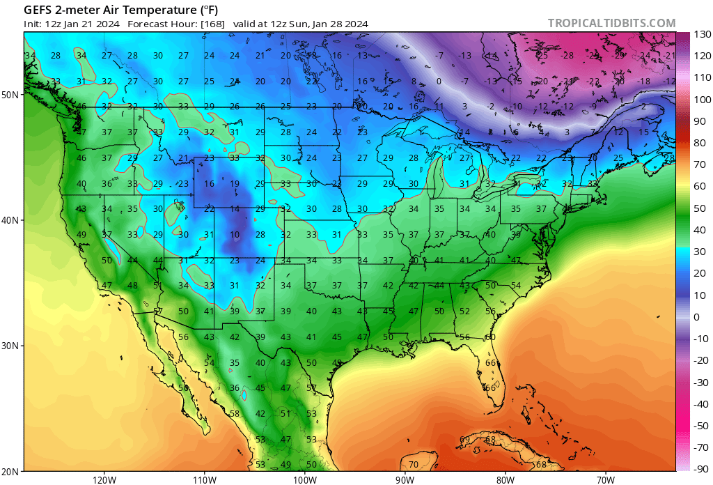
You know, this isn’t exactly a textbook pattern that gets us salivating and staying up late for euro runs. Look at the weak aleutian ridge, retracted jet, and a central US trough with a downstream WAR. The only good thing was the -AO/-NAO block. Somehow we got the cold here far enough to suppress the SE ridge to prevent it from linking up with the NAO. It partly explains why we did not get a 20 inch KU, but it should give us hope that we can still find ways to snow even a nina-like pacific paired with a -NAO (kind of like the 1960s?) Funny, if you showed me this plot back in November without telling me what happened this week, I’d scoff with disappointment and think it’d just be yet another cutter. -
Yeah, these are two different paths to a memorable stretch of winter. One is tracking an incoming HECS and experiencing incredible rates and sheer accumulations. Another is getting a series of surprise/overperforming hits with cold and longer lasting snow pack… not necessarily MECS but how often do we get upgraded to a warning from an advisory twice in the same week?
-
Mid-Atlantic Snow Totals Thread - Winter 2023-2024
Terpeast replied to mattie g's topic in Mid Atlantic
12/11: 0.5” 1/1: T 1/6: 0.2" (sleet/snow mix) 1/15-16: 4.8” 1/19: 5.5” Total so far: 11.0” -
Snow depth around 8” give or take. Loving it out there! Skies clearing to the west for a pastel pink sunset that colors the winter wonderland. Beautiful. Final deck pic: