Terpeast
-
Posts
6,615 -
Joined
-
Last visited
Content Type
Profiles
Blogs
Forums
American Weather
Media Demo
Store
Gallery
Everything posted by Terpeast
-
Jan/Early Feb Medium/Long Range Discussion Part 3
Terpeast replied to WinterWxLuvr's topic in Mid Atlantic
El Nino -
Jan/Early Feb Medium/Long Range Discussion Part 3
Terpeast replied to WinterWxLuvr's topic in Mid Atlantic
STJ going wild -
Jan/Early Feb Medium/Long Range Discussion Part 3
Terpeast replied to WinterWxLuvr's topic in Mid Atlantic
Agreed. That map Ji posted looks like 2022-23. I wasn’t joking about planning a trip out west. -
Jan/Early Feb Medium/Long Range Discussion Part 3
Terpeast replied to WinterWxLuvr's topic in Mid Atlantic
Time to plan a ski trip to Whistler then -
Jan/Early Feb Medium/Long Range Discussion Part 3
Terpeast replied to WinterWxLuvr's topic in Mid Atlantic
Yep, when I predicted 20-40” for our sub, I gave DCA a “siting penalty” of -30% which comes to roughly 14-28”. Too bad -
47, fog. Snow cover is gone. That was a good 10 days of snow pack.
-
Jan/Early Feb Medium/Long Range Discussion Part 3
Terpeast replied to WinterWxLuvr's topic in Mid Atlantic
Well, don’t look now but 6z op shows 3 hits down underneath into NC. Right where we want it? Btw I’m not worried about lack of snow on the means on the weeklies. It’s just not something to take seriously until discrete threats show up in range. -
Jan/Early Feb Medium/Long Range Discussion Part 3
Terpeast replied to WinterWxLuvr's topic in Mid Atlantic
This can easily support snow if it’s falling at night and the 850 low passes south of us. Let’s give it a few more cycles, and if euro and gfs continue this trend and bring colder air in a bit earlier & souther, we can start honking. Still too early to think of this beyond anything more than snow TV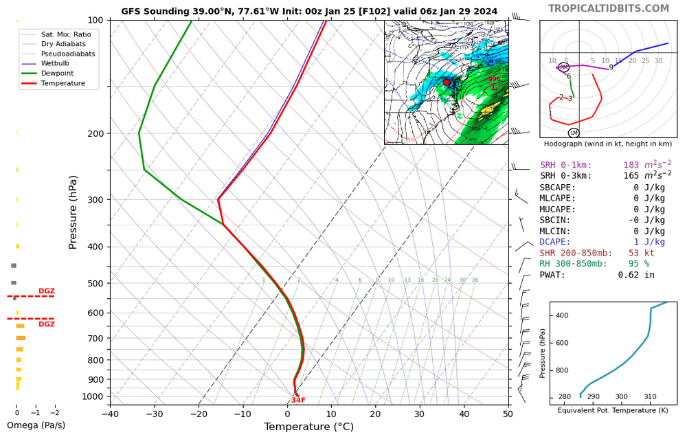
-
Jan/Early Feb Medium/Long Range Discussion Part 3
Terpeast replied to WinterWxLuvr's topic in Mid Atlantic
On the gfs the 850 low was over W PA 2 runs ago, and now its overhead if not a bit south of us. Still skeptical, and need other model support. Could be gfs moving closer to euro/cmc, but the latter two are still a bit too warm. Best case scenario for us is mostly rain and ending as snow with a coating. But we shall watch and see. -
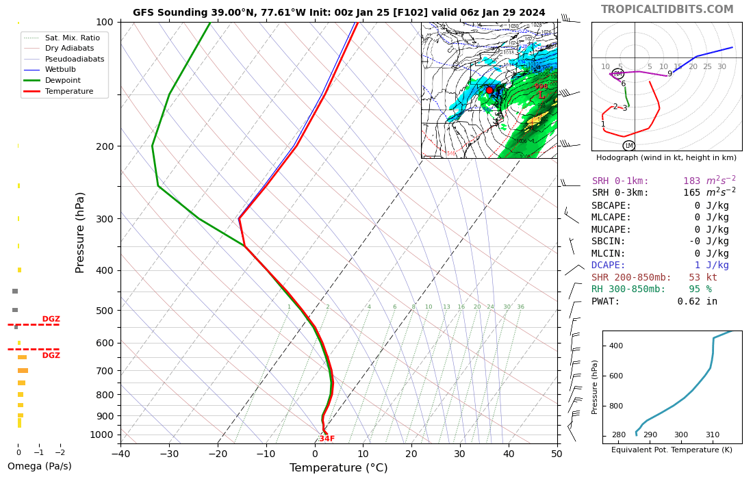
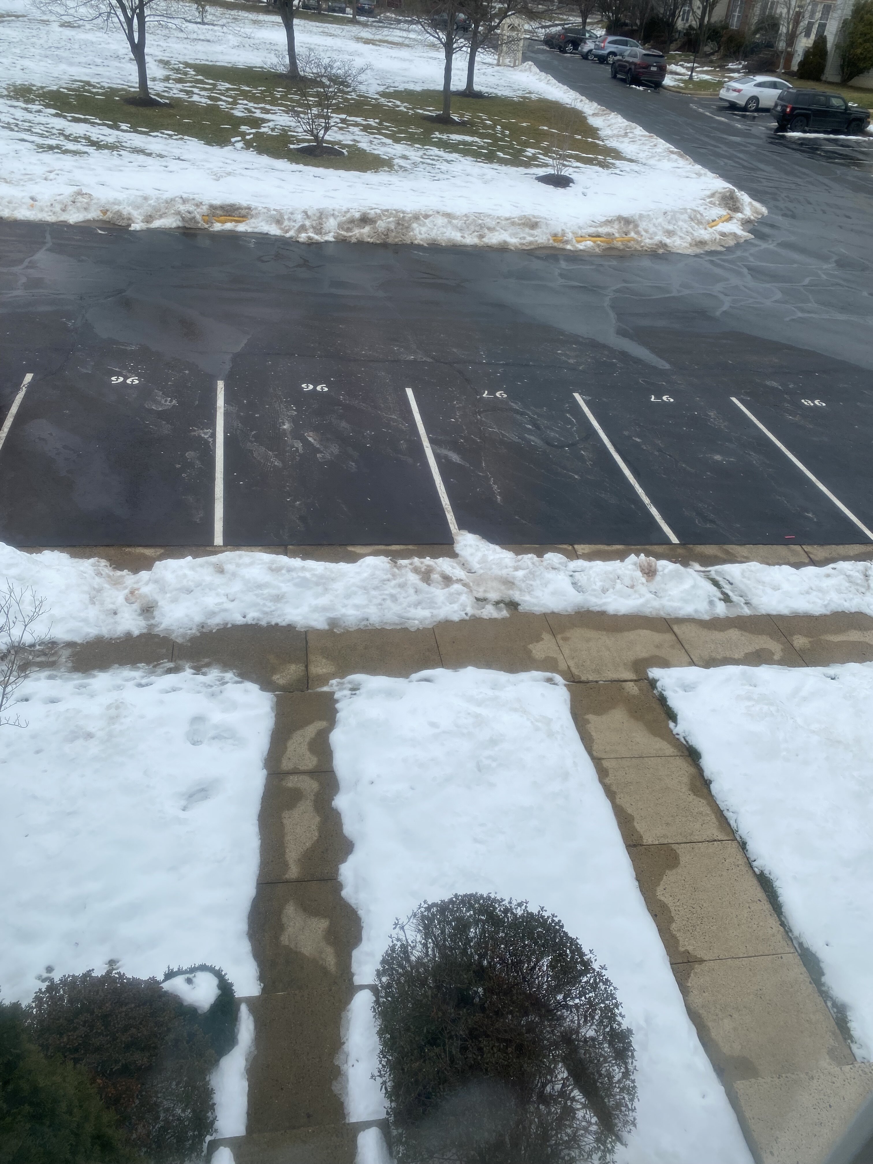
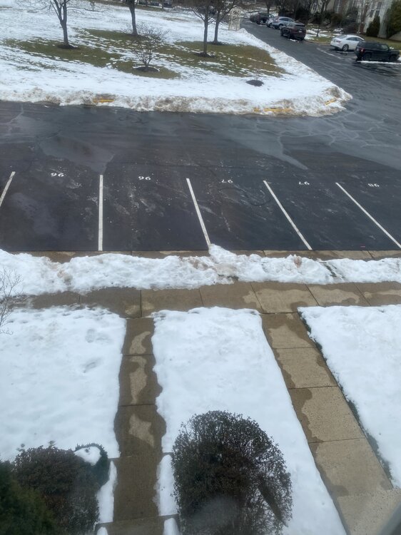
Many areas got whacked. Likely gone by tomorrow afternoon
-
Jan/Early Feb Medium/Long Range Discussion Part 3
Terpeast replied to WinterWxLuvr's topic in Mid Atlantic
H5 looks great. Near perfect. But what matters is what we have at the surface. How cold does it get, not just when it's dry, but when it's precipitating. Do we get a good high to the north when we get an incoming wave? Where does the r/s line lie? Those details obviously can't be resolved this far out, and I'd be highly skeptical of snow maps at 3 weeks out. Take last week for example - 3 weeks or even 1 week prior, snow maps barely showed an inch and we ended up getting ~10 in one week! I don't remember seeing a snow map like that on the weeklies that far out. If anything, they were further north across PA into SNE, even up until 2 days before the second wave, and then it dunked south at the last possible minute. -
Jan/Early Feb Medium/Long Range Discussion Part 3
Terpeast replied to WinterWxLuvr's topic in Mid Atlantic
Nice... and this is entirely before the "good" pattern starting Feb 8-12ish?? -
Jan/Early Feb Medium/Long Range Discussion Part 3
Terpeast replied to WinterWxLuvr's topic in Mid Atlantic
True, but we had the cold air. This time we don't. -
Jan/Early Feb Medium/Long Range Discussion Part 3
Terpeast replied to WinterWxLuvr's topic in Mid Atlantic
Agreed. I think E PA / N NJ wins this one. Not sure about NYC metro. High elevs in our sub may get a little bit, too -
Still good. Especially shaded areas facing NW
-
Jan/Early Feb Medium/Long Range Discussion Part 3
Terpeast replied to WinterWxLuvr's topic in Mid Atlantic
We got "lucky" twice last week but that was when there was plenty of cold air. I don't think we luck into this one this time, except for higher elevations (I'm looking at you, PSU). For the rest of us, we wait until 2nd week of Feb, maybe a bit sooner. -
36. 10 days of snowpack. Hanging tough at 3-4 inches in most areas, with some bare ground showing now. It was interesting to see which spots imby hang on the longest and which melt off first…
-
Jan/Early Feb Medium/Long Range Discussion Part 3
Terpeast replied to WinterWxLuvr's topic in Mid Atlantic
Yep looks that way. Positive sign. In February, every day counts! -
Jan/Early Feb Medium/Long Range Discussion Part 3
Terpeast replied to WinterWxLuvr's topic in Mid Atlantic
I like it. As long as there is no can kicking. get that thing to undercut is how we win -
Jan/Early Feb Medium/Long Range Discussion Part 3
Terpeast replied to WinterWxLuvr's topic in Mid Atlantic
I think many of us, including myself, have selective memories of our winters where we live. We tend to remember the snowiest highlights of each winter, while memories of warm/rain with brown ground fade away. This effectively magnifies how much snow we think we ought to see here. Before y’all come at me, I say again that I’m guilty of this too Plus kids here got 10 full days of sledding. I’m sure they’ll have good memories of this period. -
Low of 21
-
Jan/Early Feb Medium/Long Range Discussion Part 3
Terpeast replied to WinterWxLuvr's topic in Mid Atlantic
Beautiful split flow right there, stronger branch south -
Jan/Early Feb Medium/Long Range Discussion Part 3
Terpeast replied to WinterWxLuvr's topic in Mid Atlantic
Good. That’s the sign I was looking for. This is the opposite of a can kick -
Low of 9
-
Jan/Early Feb Medium/Long Range Discussion Part 3
Terpeast replied to WinterWxLuvr's topic in Mid Atlantic
Yeah I need a break, too. I can’t imagine a year like 2013-14 while working remotely and taking care of my daughter who is almost 3. After a crazy week, I took a nap today and slept for almost 4 hours!