

Terpeast
-
Posts
6,686 -
Joined
-
Last visited
Content Type
Profiles
Blogs
Forums
American Weather
Media Demo
Store
Gallery
Everything posted by Terpeast
-
Just need 30 miles west
-
Yeah thats not half bad
-
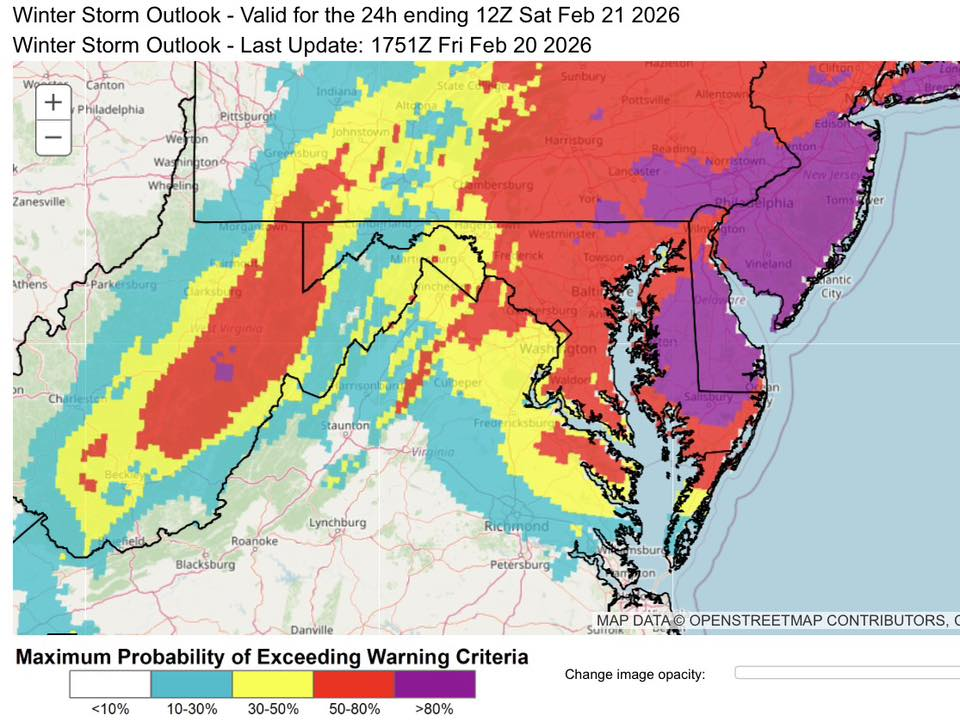
Your forecast gets me into the warning criteria
-
-
-
Feb 22nd/23rd "There's no way..." Storm Thread
Terpeast replied to Maestrobjwa's topic in Mid Atlantic
3-5 imby, 4-6 DC north -
Feb 22nd/23rd "There's no way..." Storm Thread
Terpeast replied to Maestrobjwa's topic in Mid Atlantic
A good hold by the GEFS. I'd cut those snow amounts by 30% NW of 95 to account for thermals in the first half of the storm, and maybe even by half SE of the fall line unless they get crazy rates (which it looks like they might). -
Feb 22nd/23rd "There's no way..." Storm Thread
Terpeast replied to Maestrobjwa's topic in Mid Atlantic
Yeah, and at least we have the temps going for us as we're well NW of the cities/fall line. Modeled radar shows heavy precip and that could be enough to get accumulating snow during the day time if the GFS is right. -
Feb 22nd/23rd "There's no way..." Storm Thread
Terpeast replied to Maestrobjwa's topic in Mid Atlantic
Still changes with the SW canada shortwave on gfs even at hour 18 -
Feb 22nd/23rd "There's no way..." Storm Thread
Terpeast replied to Maestrobjwa's topic in Mid Atlantic
Yep, we've been in a -PNA regime for weeks now. We're lucky we're even talking about snow at all rn -
Feb 22nd/23rd "There's no way..." Storm Thread
Terpeast replied to Maestrobjwa's topic in Mid Atlantic
That's 6z? -
Feb 22nd/23rd "There's no way..." Storm Thread
Terpeast replied to Maestrobjwa's topic in Mid Atlantic
Haha, that’s how he rolls! -
Feb 22nd/23rd "There's no way..." Storm Thread
Terpeast replied to Maestrobjwa's topic in Mid Atlantic
No I mean the thermals part. It was correct about the warm nose on Jan 25 -
Feb 22nd/23rd "There's no way..." Storm Thread
Terpeast replied to Maestrobjwa's topic in Mid Atlantic
Probably time to start looking at cams for thermals now though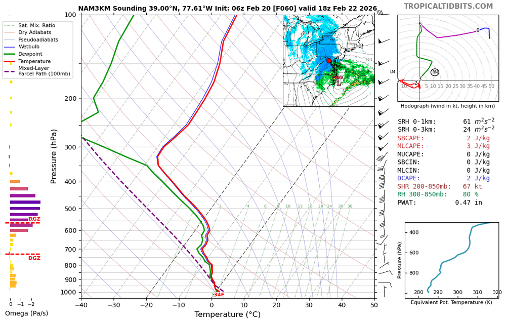
-
Feb 22nd/23rd "There's no way..." Storm Thread
Terpeast replied to Maestrobjwa's topic in Mid Atlantic
High end updated from LWX (low end is 0-T of course haha) -
Feb 22nd/23rd "There's no way..." Storm Thread
Terpeast replied to Maestrobjwa's topic in Mid Atlantic
I think we should be rooting for a later start time either way. Get the clouds here during the day to hold off the sun angle, and then thump overnight for best snow-maxing -
Feb 22nd/23rd "There's no way..." Storm Thread
Terpeast replied to Maestrobjwa's topic in Mid Atlantic
Split them down the middle, and account for temps, perhaps 3-5" for us and 4-8"+ DC and northeast -
Feb 22nd/23rd "There's no way..." Storm Thread
Terpeast replied to Maestrobjwa's topic in Mid Atlantic
Yeah the ratios probably won't be 10:1. I'd probably go with 70% of that -
Feb 22nd/23rd "There's no way..." Storm Thread
Terpeast replied to Maestrobjwa's topic in Mid Atlantic
qpf/snow ticked up (or west) with 6z gefs -
Feb 22nd/23rd "There's no way..." Storm Thread
Terpeast replied to Maestrobjwa's topic in Mid Atlantic
Well this is Maestro's storm, so maybe it is really happening! -
Feb 22nd/23rd "There's no way..." Storm Thread
Terpeast replied to Maestrobjwa's topic in Mid Atlantic
GEFS more interaction in the mean between ns and ss out west at 30 -
Feb 22nd/23rd "There's no way..." Storm Thread
Terpeast replied to Maestrobjwa's topic in Mid Atlantic
I think gfs and euro camps are starting to meet in the middle. Hopefully the middle is as beefy in qpf as this -
Feb 22nd/23rd "There's no way..." Storm Thread
Terpeast replied to Maestrobjwa's topic in Mid Atlantic
foot plus for dc metro, more towards the bay and delmarva (2 feet) I'd mentally cut those amounts by 20-30% considering daytime snow and temps. -
Feb 22nd/23rd "There's no way..." Storm Thread
Terpeast replied to Maestrobjwa's topic in Mid Atlantic
Very nick tuck. northern Delmarva gets the goods -
Feb 22nd/23rd "There's no way..." Storm Thread
Terpeast replied to Maestrobjwa's topic in Mid Atlantic
Looks maybe a few hours faster


