Terpeast
-
Posts
6,687 -
Joined
-
Last visited
Content Type
Profiles
Blogs
Forums
American Weather
Media Demo
Store
Gallery
Everything posted by Terpeast
-
Feb 22nd/23rd "There's no way..." Obs Thread
Terpeast replied to Maestrobjwa's topic in Mid Atlantic
I sure hope so, we’d be right in the middle of that if correct -
Feb 22nd/23rd "There's no way..." Obs Thread
Terpeast replied to Maestrobjwa's topic in Mid Atlantic
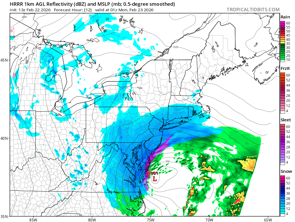
Preface by noting two different forecast time stamps. We should know where the norlun is setting up by 22z-00z (5-7 pm est) based on radar sigs from the CAMs: My guess is we will know by 5-6 pm

-
Feb 22nd/23rd "There's no way..." Obs Thread
Terpeast replied to Maestrobjwa's topic in Mid Atlantic
Yeah, even those seeing sn/rasn now probably won’t accumulate much beyond an inch until everyone flips after 5 pm still, I’d feel better if i’m at 35-36 now -
Feb 22nd/23rd "There's no way..." Obs Thread
Terpeast replied to Maestrobjwa's topic in Mid Atlantic
37.9, oof! -
Feb 22nd/23rd "There's no way..." Obs Thread
Terpeast replied to Maestrobjwa's topic in Mid Atlantic
It doesn’t flip us until 22z (5 pm) and still gives us 6” give or take -
Feb 22nd/23rd "There's no way..." Obs Thread
Terpeast replied to Maestrobjwa's topic in Mid Atlantic
Raining good, nothing mixing in. 37/35 still -
Feb 22nd/23rd "There's no way..." Obs Thread
Terpeast replied to Maestrobjwa's topic in Mid Atlantic
Most pws obs around me are at 36 -
Feb 22nd/23rd "There's no way..." Obs Thread
Terpeast replied to Maestrobjwa's topic in Mid Atlantic
Consistent with my 37/35 atm. Need a lot of work to get down to freezing. -
Feb 22nd/23rd "There's no way..." Obs Thread
Terpeast replied to Maestrobjwa's topic in Mid Atlantic
Your guess is as good as mine. It’ll be a narrow band only 10-20 miles wide. Either we’re in a good spot for it or not. We’ll probably know the answer to this early tomorrow evening when it begins to form. -
Feb 22nd/23rd "There's no way..." Obs Thread
Terpeast replied to Maestrobjwa's topic in Mid Atlantic
I think there’s a limit to how far east it’ll go as the sfc low track is pretty much locked in +/- 30 miles, and most models have had the norlun from HGR - W loudoun - Fauquier though it shifted east by maybe 10-20 miles on 00z. I don’t think it’ll shift further east by more than 10-20 miles, and certainly not to bmore unless the storm actually changes track -
Feb 22nd/23rd "There's no way..." Obs Thread
Terpeast replied to Maestrobjwa's topic in Mid Atlantic
36/31, ticking down -
Feb 22nd/23rd "There's no way..." Obs Thread
Terpeast replied to Maestrobjwa's topic in Mid Atlantic
Gfs shifted that norlun east every run over the last 6 runs, while keeping the ccb and slp largely the same. Interesting -
Feb 22nd/23rd "There's no way..." Obs Thread
Terpeast replied to Maestrobjwa's topic in Mid Atlantic
It wants to put that norlun over us -
Feb 22nd/23rd "There's no way..." Obs Thread
Terpeast replied to Maestrobjwa's topic in Mid Atlantic
38/30, dropped two degrees in the past hour -
Feb 22nd/23rd "There's no way..." Obs Thread
Terpeast replied to Maestrobjwa's topic in Mid Atlantic
Just now catching up - had company over today so was quiet. Looks like the ccb may not get far enough west here, and I don’t want to gamble on the norlun, I’m thinking the local min may be imby or close. Running out of time for bigger changes. Should be a great storm with double digits E/NE of DC, and maybe someone lucky will see 10” from the norlun (and I don’t think its going to be me). Historic for DE/PHL/NJ/NYC/BOS, though! Fun to watch from a met perspective. PS. i’m at 40/29. Tad warm, not sure what the models had me at for this time. -
Soundings have us at 33-34 at 18z tomorrow. Other runs/models were 35-37
-
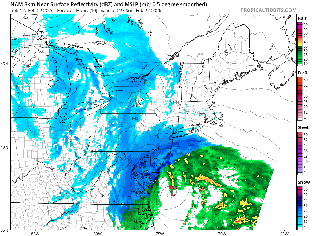
Thats what the western suburbs need! Slp is 10-20 miles NW but the precip shield is way west and heavier because of better H5 as you showed in your pbp
-
More energy from trailing vort sucked into the main one
-
Yeah, it doesn’t match climatology of past storms like this.
-
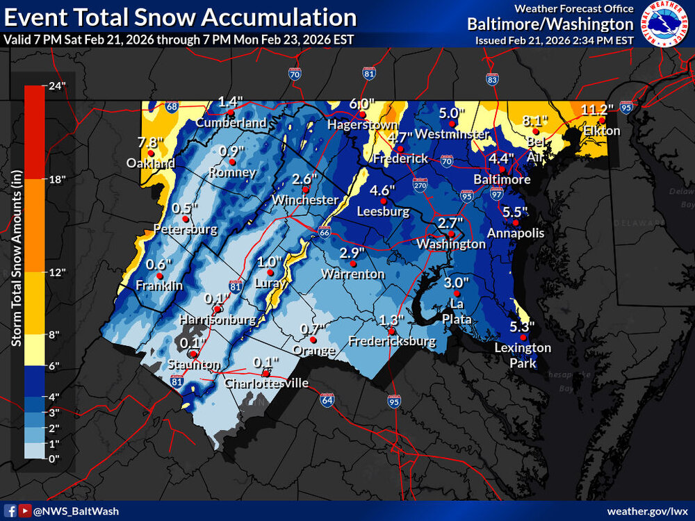
I would adjust bmore up to 7” and also winchester is probably way too low
-
-
Nice! I can see something like this happening if the lows tuck west and throws the ccb further west into nova/81. Let’s see if 18z/0z models start showing this
-
That’s how I would do it. It’s not a 3” fluffy powder WWA type of event. It’s a 4”+ heavy dripping wet slush that will weigh down trees and limbs and power lines.
-
If they turn out to be correct (which is unlikely but not impossible), we could get the CCB all the way to 81
-
We may well get pummeled with that if lucky. Even if not, euro was a great shift in our favor