Terpeast
-
Posts
6,682 -
Joined
-
Last visited
Content Type
Profiles
Blogs
Forums
American Weather
Media Demo
Store
Gallery
Everything posted by Terpeast
-
Agreed. The duration of cold and snow cover making it feel like a real classic winter as long as we just put our phones down and take it all in. I’d give it a B- at least. But based on vibes and tracking, I feel last winter was more fun.
-
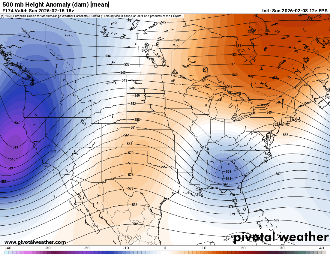
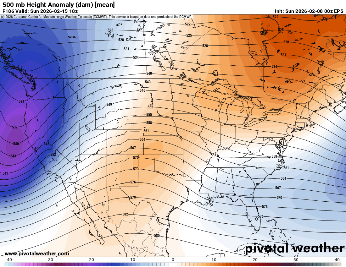
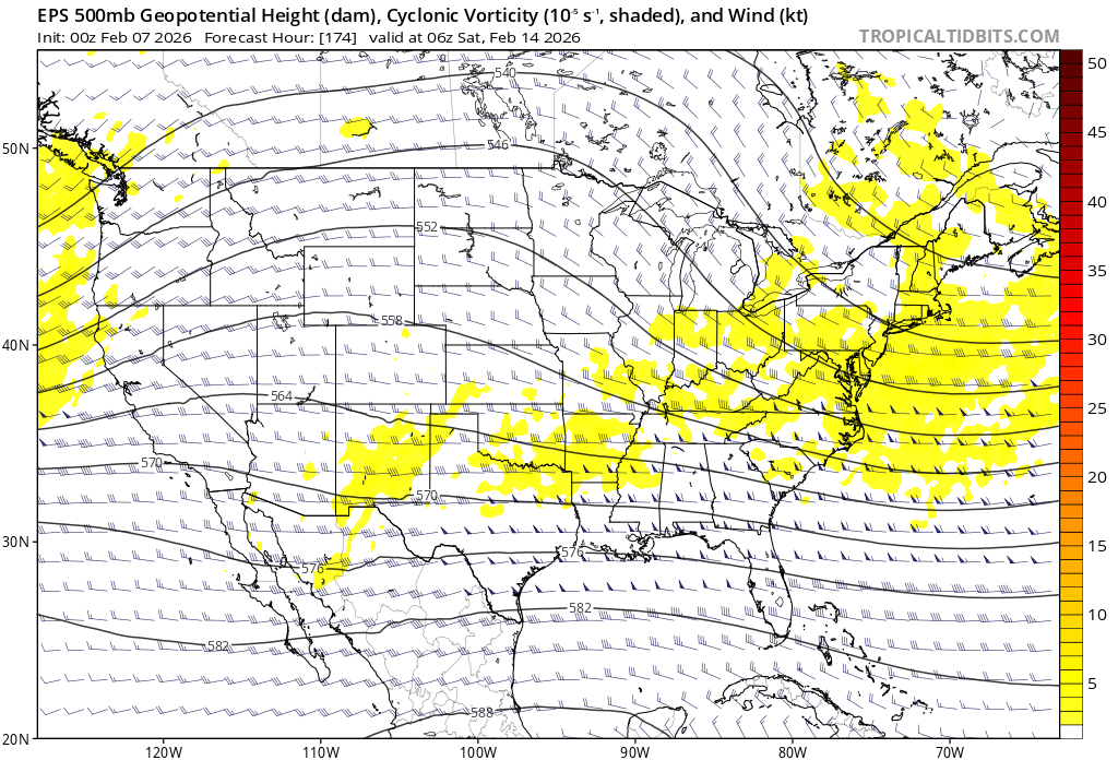
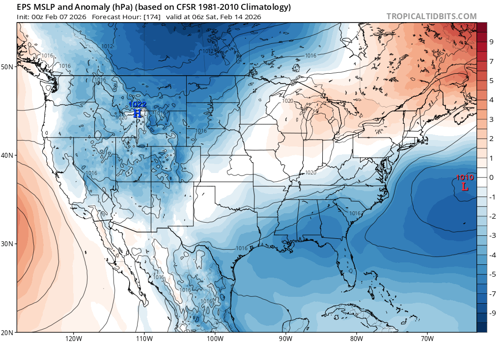
Seeing the EPS mean is reassuring. The op runs can be expected to windshield wiper around the ensemble means, as they trend closer to the final solution, which we will have a better idea by Wednesday Upon closer inspection, EPS (and AI EPS) has reversed its weakening trend and re-strengthens the s/w on approach. Hudson bay high and confluence also stronger, better cold air mass. New run: Old run:


-
Winter Storm Threat *Technical* Discussion. No Op Run PBP or Snow maps
Terpeast replied to CAPE's topic in Mid Atlantic
Seeing the EPS mean is reassuring. The op runs can be expected to windshield wiper around the ensemble means, as they trend closer to the final solution, which we will have a better idea by Wednesday Upon closer inspection, EPS (and AI EPS) has reversed its weakening trend and re-strengthens the s/w on approach. Hudson bay high and confluence also stronger, better cold air mass. New run: Old run:
-
12z euro suite says Chuck’s right
-
Taking it to banter. This winter we’ve had lots of cold and almost no torching. But that made for a frustrating season for tracking storms because we’ve been too dry. Apart from the major winter storm, we’ve had both a sheer lack of minor events and big misses to the south. Last winter was more fun in terms of tracking because we had plenty to track between early Jan and mid Feb (although we didn’t get the happy ending we wanted then). This year we didn’t have as many events to track, and when we did, it was frustrating when we were willing something to happen the way we wanted and got a close miss instead.
-
Winter Storm Threat *Technical* Discussion. No Op Run PBP or Snow maps
Terpeast replied to CAPE's topic in Mid Atlantic
Honestly. The idea is good at first, but it gets a bit annoying checking and posting in both threads. Idk what the answer is. -
Winter Storm Threat *Technical* Discussion. No Op Run PBP or Snow maps
Terpeast replied to CAPE's topic in Mid Atlantic
Yes, for once, please. -
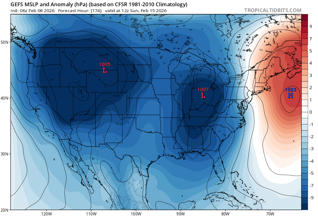
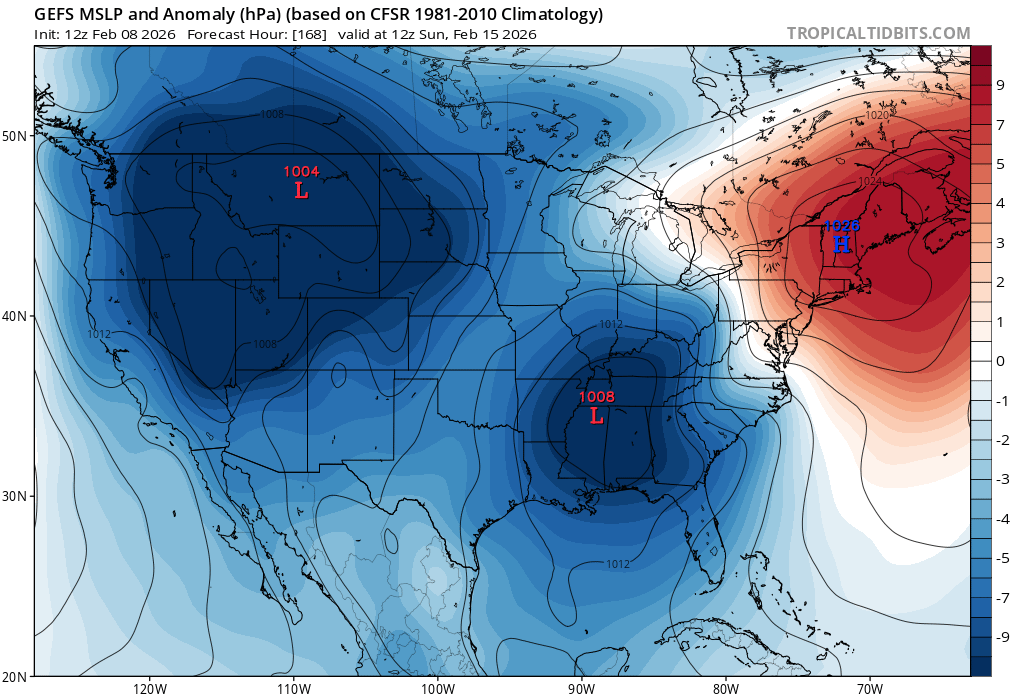
Big change on gefs. Last run was a cutter in the mean, shifted way south into the TVA for mean slp. new run: old run:


-
Sadly I agree. The lead wave runs too far ahead of the main wave, and the main amps too much throwing up too much warm air ahead of it. Verbatim NW of 95 may start out as wet snow then quickly flip to rain
-
Winter Storm Threat *Technical* Discussion. No Op Run PBP or Snow maps
Terpeast replied to CAPE's topic in Mid Atlantic
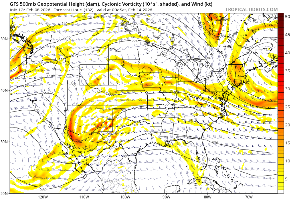
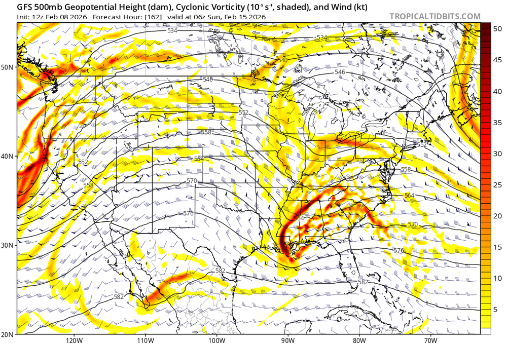
12z gfs just showed us the win scenario we all need, including the lowlands. First, we need a lead shortwave (over MN/IA at 132 hr) to reinforce cold air just before the main wave (over AZ/NM) arrives. And the main wave is strong enough to maintain a miller A with sufficient gulf feed: We don’t want them to phase too early else it will cut, and we also don’t want zero interaction between the two streams either.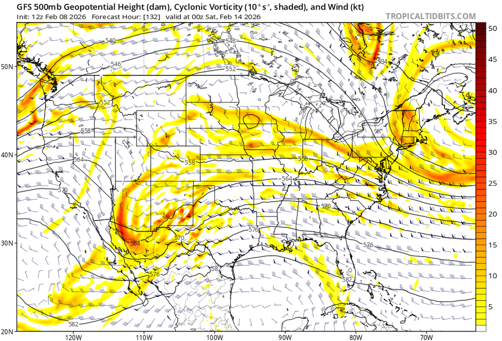
-
Doing better than me, and I traditionally have higher snow climo. I’m at just under 13” so far, normal is around 20-22”
-
Will wait until 84 hours out to be certain, but I’m starting to think that we’ve lost this one. Maybe it’ll morph into a minor event?
-
Winter Storm Threat *Technical* Discussion. No Op Run PBP or Snow maps
Terpeast replied to CAPE's topic in Mid Atlantic
Disappointed, but not surprised. The red flag yesterday and even the day before was that guidance was trending weaker with the undercutting energy beneath the hudson bay ridge. -
Probably not. Gfs moved the low from international falls to cleveland in one run.
-
Winter Storm Threat *Technical* Discussion. No Op Run PBP or Snow maps
Terpeast replied to CAPE's topic in Mid Atlantic
Bringing this over here. Better place! -
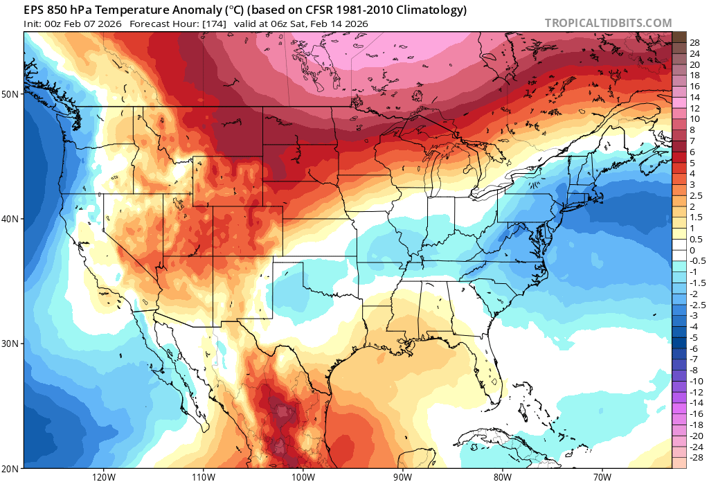
I checked EPS and AI EPS to try to challenge you on that assertion, but came up inconclusive. We do start out with a strong -NAO block but then it decays and retrogrades SW into Quebec as the system approaches. That’s not the problem in my opinion. The real issue is that the “undercutting” wave energy has trended weaker/flatter. If it’s less dynamic, we could end up too warm for snow, which may not really matter if its dry or low qpf anyway. I would prefer to see a stronger wave that will help keep us cold, or perhaps having a lead wave reinforce cold air for the follow up. Lots of moving parts…
-
Winter Storm Threat *Technical* Discussion. No Op Run PBP or Snow maps
Terpeast replied to CAPE's topic in Mid Atlantic
With that depiction verbatim, I think the first wave will actually work better for us on the 13th. By the time the second one gets here, cold air might be leaving. Details will change and we will know soon enough which wave the models are really keying on for us. -
Depends which models are putting up the goal posts. Imagine if the cutter was depicted by the AI Euro instead of the gfs. Cliff jumping galore
-
Winter Storm Threat *Technical* Discussion. No Op Run PBP or Snow maps
Terpeast replied to CAPE's topic in Mid Atlantic
Just looked at gefs, and you’re right on that one. But 12z EPS doesn’t cut and is actually better for us than 0z or 6z. Still sticking with the undercutting the block idea, while 12z gefs links up ridging preventing the s/w from undercutting -
Winter Storm Threat *Technical* Discussion. No Op Run PBP or Snow maps
Terpeast replied to CAPE's topic in Mid Atlantic
you mean EPS? Or GEFS? -
Yes, a weaker pv supports blocking. It doesn’t have to reverse for blocking to suddenly appear.
-
Winter Storm Threat *Technical* Discussion. No Op Run PBP or Snow maps
Terpeast replied to CAPE's topic in Mid Atlantic
I think that scenario is less likely based on ensembles, they don’t really support the suppressed scenario. Agree timing is vital, 6z Euro AI ensembles show something similar to 0z EPS with undercutting energy under the block but ridge bridging happens immediately after passing us. -
Winter Storm Threat *Technical* Discussion. No Op Run PBP or Snow maps
Terpeast replied to CAPE's topic in Mid Atlantic
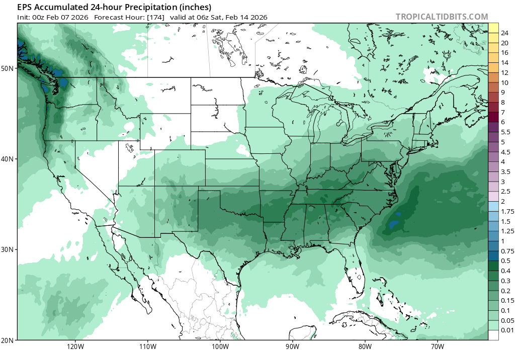
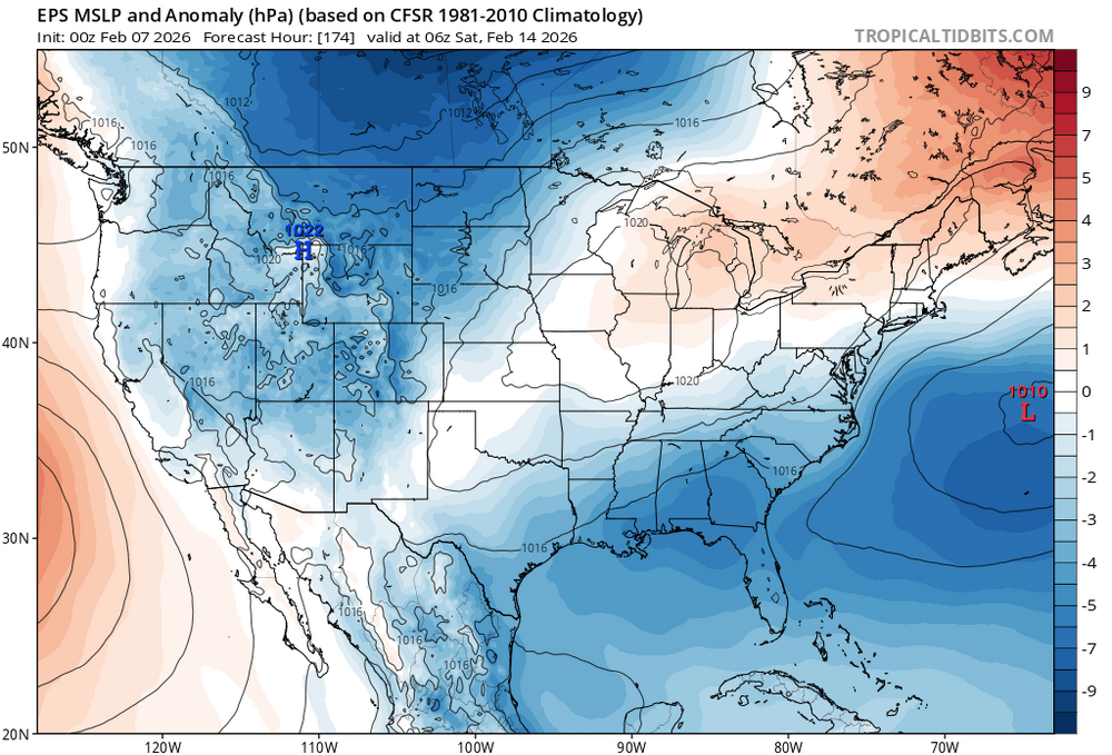
Good call. I’ll start. Focusing on 0z EPS. Next window of interest, s/w running into confluence thanks to 50/50 low: Keeping cold air in place: While area of low pressure stays to the south of us: And precip distribution looks good: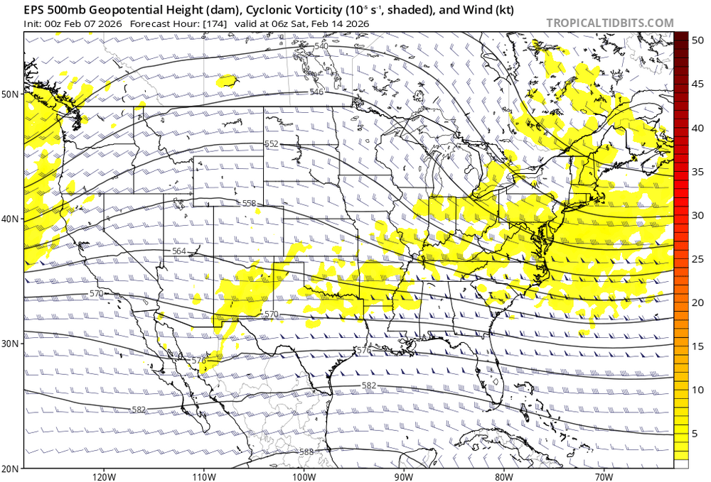


-
Incredible how close your numbers have been. You’ll probably beat last year, but I had 16.9” last winter and I’m at 12.8” so far. In 23-24 I had 13.2”