

Terpeast
-
Posts
6,682 -
Joined
-
Last visited
Content Type
Profiles
Blogs
Forums
American Weather
Media Demo
Store
Gallery
Everything posted by Terpeast
-
Roughly an inch of slush. I take
-
Winter Storm Threat *Technical* Discussion. No Op Run PBP or Snow maps
Terpeast replied to CAPE's topic in Mid Atlantic
If we remember the seasonals’ DJF precip anomaly forecast, it was bone dry and I was thinking “no STJ this winter then?” We’re lucky to get 8-11” frozen from a STJ wave that drove into the OHV. -
Unfor for me and my dc metro brethen I think you may be right. Still a chance for a last second overperforming surprise
-
Can’t say I’m surprised. Feb-Mar usually torches during a Nina, with a few exceptions. In fact this was baked into my winter outlook.
-
It hasn't snowed at all in March since I moved back here in 2022. Ok maybe some snow TV but no accums at all.
-
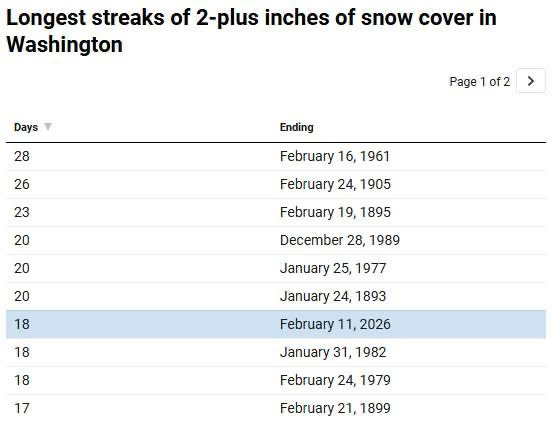
(Source: CWG WaPo) This winter deserves high marks just for this reason alone. I know I know, frustrating tracking season and tons of teeth gnashing over near misses… but the snow/ice cover and duration of cold is impressive. With how much I have on the ground now, still 4-5”, I’m making a run for 21 days
-
(Source: CWG WaPo) This winter deserves high marks just for this reason alone. I know I know, frustrating tracking season and tons of teeth gnashing over near misses… but the snow/ice cover and duration of cold is impressive.
-
19” jack at Atlantic beach. It could have been us. Glass half full take - if it can happen down there, we still have our chances. Maybe not this season, but next year during an el nino we might get a hit.
-
For now I’m considering 6z euro a “blip” and given thermals, the high snow accums may be a mirage. But there’s still time. We’re starting to enter the inevitable model reshuffling period (D3-5) where things can really change. Maybe for once the reshuffle goes in our favor?
-
When you have Detroit and Buffalo in the mid 30s, we know we are in real trouble down here. Again, interior paste-bomb upside doesn't change.
-
Based purely on gut feel… upside is a wet 2” paste job NW of 95 before flipping to rain. I’ll take the stat padder while holding out hope for a last winter gasp end of feb or early march
-
Thanks to that one storm that defined the entire winter, this season has already outdid many of the winters I remember growing up here.
-
Low of 9
-
I think what PSU is trying to say is that the fast pattern flip in the pac takes a few days to affect the east. I know you said the time lag is 0 days, but I don’t agree. There is a limited window of time where we can still get a snowstorm before the warmup happens.
-
And that’s a wrap. Back to regularly scheduled storm tracking
-
Most boring superbowl I’ve ever watched. Halftime show was the most interesting part and I’m not trolling
-
Sounds like I didn’t miss much. I’ve pretty much tuned out all the commercials
-
The temperature part doesn’t surprise me, but the below average precip does
-
Great halftime show. Helps I know a bit of spanish
-
Very fragile setup, yes
-
In general… the quicker we can get the storm here the better, in this situation.
-
Pats have to be glad going into the half down “only” 9-0 with the way the offense has been playing. They need major halftime adjustments. Defense is playing well.
-
Only first half but Pats are in trouble
-
I’m going with the Pats!
-
Legit question. AI EPS has been one of the best models/ensembles in terms of verification at these lead times (one week or more). However, the best practice is to check how the same model has been trending from run to run. Even though the s/w trough on the AI EPS isn’t as sharp as the original EPS, it also has trended the same way as EPS did. The AI models usually smooth things out too much so they don’t do well predicting extremes (or sharpness of trough waves one week out). So my answer would be that both AI and non-AI EPS suites showed similar results for 12z.


