-
Posts
4,503 -
Joined
-
Last visited
Content Type
Profiles
Blogs
Forums
American Weather
Media Demo
Store
Gallery
Everything posted by Baum
-
you yesterday: "Look at it like this. In order for most of us here to experience the Winters of Yore, we may have had to participate in World War 2?? Having the winters get warmer and more frustrating may be a small price to pay, if you know what I mean." zzzzzzzzzzzzzzzzzzzzz
-
While I'm old enough to remember Chicago's 1967 blizzard(age 5) and the great winters of the late '70's(high school) I would say the Ground Hog day blizzard and the winter of 2014 are on par or may top them. The wind and combined snow lightning and thunder of GHD storm are the most extreme winter event I observed. And those winters of the late '70's were not 150 days of bitter cold/snow. They came early but were pretty much gone by mid February.
-
probably just get a 15 inch snow event at some point and end the season under 30".
-
until I see I see in depth pattern change discussions from folks I put credence in or posting of such from respected non board sourcesI would have no faith in any event showing on any model. Sadly, the type of event we are experiencing today normally leads to a pattern change instead will be well into the 60's by mid week. Although, what I thought could be a sunny and 70 degree day looks off the table now.
-
"FINALLY, DEFORMATION FORCING ALONG THE BACKSIDE OF THE LOW AS WELL AS FALLING TEMPERATURES WILL SUPPORT A BAND OF SNOW ARCING BACK ACROSS FAR EASTERN IOWA AND NORTHERN ILLINOIS TOWARD DAYBREAK SATURDAY. SINCE THE LOW WILL BE PULLING AWAY, THE BAND OF SNOW SHOULD HENCE LIFT NORTHWARD AS WELL. HOWEVER, AT LEAST A 2-3 HOUR WINDOW OF STEADY SNOW APPEARS PROBABLE ALONG THE IL/WI STATE LINE SATURDAY MORNING WITH A FEW TENTHS OF AN INCH OF ACCUMULATION AND LOCALLY SLIPPERY ROADS A DISTINCT THREAT (SNOW RATES APPEAR TO BE AT OR BELOW 0.25"/HR). " desperation thy name is LOT.
-
suspect early Pink Floyd before the drugs.
-
only those of us that followed JB back in his hey day understand the "rubber band theory" and "and if the flip to cold and snow comes around the solstice it's here to stay" or "vodka cold" and my favorite, "there will be storms and rumors of storms." The last usually used in a pattern much like were in where the country is flooded with warm pacific air and there is no chance in hell of it snowing in most locales. And yet, he could argue the storm this weekend with wind and rain verified. All this for $14.95 a month to keep a snow weenies hopes alive. And people call him, dumb.
-
going to be glorious.
-
I'll keep the discussion going only because there is not much else to talk about. My recollection of real memorable snowfalls prior to December 1 of each year is as follows: 1975. Thanksgiving weekend event measured perhaps 9" compacted to 3" of muck within hours. December 1, 1978. 13" Special year. Halloween 2019. Couple inches of wet snow, and more memorable for freezing the leaves on the trees. Not sure it snowed again until sometime in January. And than the tree snapper from Thanksgiving weekend 2018 which i still have tree damage from. Every other snowfall was nothing more than a stat padder as the saying goes. So while I understand the statistical anomaly and its impact on historical and future data it just does not send me over the edge on December 7. I'd much rather see a pattern shift to real winter when I think there is a better chance of it sticking. And based on some of the reporting from the more climatologically favored locales winter is establishing itself quite well. If I'm still spewing the same spin(shiat) on New Years than I'll walk to the edge of the cliff. Sidenote: haven't seen a flake today as of yet. 24 days to go...let the countdown begin.
-
I'm good with both. But I'm guessing we could get you stoked for 20" blizzard. Reality is I suspect it was your original "weenism" that led you to do this as a professional career. It certainly led me in that direction, until I realized it required math skills. So now, I'm a professional weather board reader. Note: I consider the term "weenism" in a positive light.
-
solid early December day on tap it appears. Slate gray sky, frosty temps in the mid-20's and some mood flakes fluttering from the sky. It's beginning to feel a bit like Christmas. Maybe, we can get a burst of flakes from the cold/dry air mass to whiten the ground and quell the stat mavens to get a .01 on the board. It'll happen when you least expect it.
-
Sorry I just don't get caught up in all the over the top panic in regards to the lack of snow and cold on December 5th. Today's and tomorrows highs in the 20's will be the coldest of the season thus far so typical December weather minus the snow to this point. Sounds like another decent warm up on the table mid month which I'm fine with. Thereafter, maybe we can get an abrupt change to winter. If not, I'll be dissapointed as I'd love to see some snow threats around the holidays for a change...it's been a few years.
-
seems like typical early December weather. The continued gradual step down into winter continues. Next few days we may not break freezing.
-
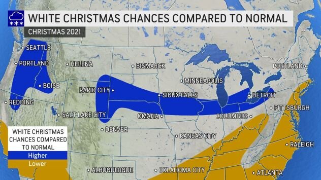
^ enjoy it while it lasts. Finish up the mid month Christmas shopping. I still do mine at the stores, as I enjoy the atmosphere, so a Nashville level warmth(Dallas?), won't dent my spirits to bad. All the while knowing when mother nature decides to even the score it's going to be special....perhaps right during Christmas and New Years.
-
Javier Baez 2021 season: .265 BA 31 HR 18 SB 87 RBI 2019 Season: .281 avg 29 HR 11 SB 85RBI 2018 Season: .290 34 HR 111 RBI 21 SB multi position gold glove winner on defense. sorry for the OT. But when people just spew noise minus facts you just have to set the record straight. These statistics point to a very good consistent player. What you think of his personality or playing style is subjective. Though many consider him one of the most entertaining players in the game. I think Tiger's fans will enjoy him immensely....but would agree when his swing rate fades he could fade fairly quickly. sidenote: I owned him in my highly competitive 16 team fantasy baseball league and he helped garner me my first title. Did move him late in the season due to his questionable OBP skills...but that power/speed combo tough to fine in middle infielders.
-

Winter 2021-22 Short/Medium Range Discussion
Baum replied to Chicago Storm's topic in Lakes/Ohio Valley
-

Winter 2021-22 Short/Medium Range Discussion
Baum replied to Chicago Storm's topic in Lakes/Ohio Valley
-
biggest optimist on the board. and i agree, completely.
-

Winter 2021-22 Short/Medium Range Discussion
Baum replied to Chicago Storm's topic in Lakes/Ohio Valley
Can any other weather office top this? LOT: " A 135+ KT JET STREAM EXTENDS FROM SOUTHERN BRITISH COLUMBIA ALL THE WAY THROUGH THE GREAT LAKES, WITH A 150+ KT MAXIMUM MOVING FROM THE NORTH DAKOTA/CANADA BORDER TO LOWER MICHIGAN BY FRIDAY MORNING. AS THAT JET MAX TRANSLATES, IT WILL SEND A VERY LOW AMPLITUDE MID-LEVEL WAVE TOWARD SOUTHERN WISCONSIN AND, MORE NOTEWORTHY, INCREASE A LOWER TO MID TROPOSPHERIC FRONTOGENETIC (F-GEN) CIRCULATION. GUIDANCE TODAY HAS CONTINUED THE TREND OF AN INCREASING SIGNAL OF ENOUGH SATURATION WITH THIS FOR QPF CLIPPING AT LEAST THE FAR NORTHERN CHICAGO METRO. WHILE THE OVERLAPPING SIGNAL IN GUIDANCE REMAINS BETTER FOR NORTH OF THE STATE LINE AND STILL FAIRLY LARGE SPATIAL UNCERTAINTY ON THE SOUTHERN PERIPHERY, THERE WAS ENOUGH OF A HIGH-RESOLUTION SIGNAL TO FURTHER INCREASE POPS FOR LAKE AND MCHENRY COUNTIES AND A SLIGHT BOOST IN ADJACENT AREAS. THE MAIN TIMING LOOKS TO BE ~2-7 A.M. DETERMINISTIC SOUNDINGS FROM THE NAM, GFS, RAP, AND HRRR (IRREGARDLESS OF WHETHER THEY SHOW PRECIPITATION) DO SHOW MARGINALLY WARM ENOUGH PROFILES FOR MELTING ALOFT. FURTHER BELOW, THE PROFILES IN THE BOUNDARY LAYER ARE ALSO MARGINAL, AND SOME DEPENDENCY ON EVENING TRENDS AS NOTED EARLIER. SO RATES OF ANY PRECIPITATION WILL LIKELY BE KEY IN CHANGEOVER AND IMPACTS, AND THAT WILL BE TIED TO ENOUGH WELL-ALIGNED, NEGATIVE SATURATED EPV (INSTABILITY) ON THE WARM SIDE OF THE CIRCULATION ABOVE THE F-GEN. IN GENERAL THE MODELS DO SHOW THAT, SO FEEL THAT IF THERE IS AN ESTABLISHED F-GEN BAND INTO FAR NORTHERN ILLINOIS, IT LIKELY WILL TURN PRECIPITATION TYPE OVER TO SNOW. GIVEN THE TIME OF DAY, SOME MINOR ACCUMULATIONS WOULD BE POSSIBLE WITH THIS INCLUDING ON ROADS. THE POTENTIAL FOR THIS TO OCCUR TO IMPACTING LEVELS STILL REMAINS ON THE LESS LIKELY SIDE OF THE SPECTRUM OF OUTCOMES. THE EVENING SHIFT WILL KEEP A CLOSE EYE ON IT THOUGH TO SEE IF TRENDS SUPPORT AN INCREASING CHANCE OF IMPACTS. " this is the discussion for a snow shower. -

Winter 2021-22 Short/Medium Range Discussion
Baum replied to Chicago Storm's topic in Lakes/Ohio Valley
he's been for awhile. Pops in periodically, starts a big snow thread, screws us, and than moves on. -
ahhh April.
-
^ delving in deeper: " MEDIUM RANGE MODELS CONTINUE TO FLAIL ABOUT RUN TO RUN WITH HANDLING OF A POTENTIAL MIDWEEK SYSTEM. THE LATEST OPERATIONAL RUNS ARE WEAKER AND MORE PROGRESSIVE WITH THIS WAVE THAN MANY OF THE RUNS THE PREVIOUS DAY OR TWO. OVER THE PAST WEEK, MEDIUM RANGE MODELS HAVE EXHIBITED A LOWER THAN AVERAGE SKILL LEVEL BEYOND 120 HOURS IN OVER OUR REGION AND OPTED TO MAKE NO CHANGES TO NBM GUIDANCE WHICH ADVERTISES MAINLY SNOW CHANGES IN THE TUE/WED TIME FRAME. WOULD FULLY EXPECT ADDITIONAL CHANGES TO MEDIUM RANGE OUTPUT WITH RESPECT TO THIS SYSTEM, SO THE POTENTIAL OUTCOME OF OUR WEATHER PROBABLY RUNS THE GAMUT FROM A SNOWSTORM TO RAIN TO NOTHING OF SIGNIFICANT CONSEQUENCE. KEY MESSAGE AT THIS POINT SHOULD BE THE FORECAST TUESDAY-WEDNESDAY TIME FRAME WARRANTS WATCHING OVER THE NEXT SEVERAL DAYS AS WE CAN BEGIN TO HONE IN ON A HIGHER CONFIDENCE FORECAST. " only forecaster IZZI would raise to full on pops 5 days out on a model suite that says "tone it down". Daycrew will adjust accordingly if models remain status quo. Was getting a tad excited. Reality restored.
-
looks like an early December forecast to me: TUESDAY AND TUESDAY NIGHT MOSTLY CLOUDY WITH SNOW LIKELY. HIGHS IN THE MID 30S. LOWS IN THE MID 20S. CHANCE OF PRECIPITATION 60 PERCENT.



.thumb.jpeg.1f28b7e6bdb6a543a8497932c803a2a6.jpeg)
.jpeg.611a93d5a3008f2e7e77736397b3577d.jpeg)
.jpeg.337d8a3bc9715736341b456342ee49c4.jpeg)
.png.3fd6e0eda248506355a4d3607d25460b.png)
