GramaxRefugee
-
Posts
1,754 -
Joined
-
Last visited
Content Type
Profiles
Blogs
Forums
American Weather
Media Demo
Store
Gallery
Everything posted by GramaxRefugee
-
49 Monday morning low.
-
Yup. I can't believe I clicked on it at first. And now I keep coming back like a voyeuristic addict. 29" BWI 32" IAD 23" DCA 24" RIC
-
2022 Mid-Atlantic Severe Wx Thread (General Discussion Etc)
GramaxRefugee replied to Kmlwx's topic in Mid Atlantic
Morning T-storm offered plenty of thunder but not much else until one close zap at about 6:30, plus about 0.26" rain. Currently overcast. -
67f for my high (dang!) 0.05" from numerous showers Overcast all day
-
0.25" for yesterday and overnight.
-
2022 Mid-Atlantic Severe Wx Thread (General Discussion Etc)
GramaxRefugee replied to Kmlwx's topic in Mid Atlantic
Getting a strong second round here in Annapolis. CG. Bit of hail. Smaller than pea so far. Very dark sky -
2022 Mid-Atlantic Severe Wx Thread (General Discussion Etc)
GramaxRefugee replied to Kmlwx's topic in Mid Atlantic
We're just starting to get a little rain in Annapolis . Sky not very dark...worst to the North. Radar looks kinda goofy. Be interesting to see what develops in the next 30 min Edit 14:50....Finally getting a bit of T&L plus good rain, but still not dark sky. Radio tower still plenty visible. -
Hey; might be a good name for our band. ( The record company shortens it to just "Hydrating") Some haze showing in AACo now, but plenty of sunshine.
-
This is very cool.
-
Ending May observations..... 5.16" rainfall Highest temp 92f; lowest 40f
-
2022 Mid-Atlantic Severe Wx Thread (General Discussion Etc)
GramaxRefugee replied to Kmlwx's topic in Mid Atlantic
Power flickering bad in Annapolis........1310 -
Downpour and wind at about 13:00 in Annapolis. Not too bad so far though.
-
2022 Mid-Atlantic Severe Wx Thread (General Discussion Etc)
GramaxRefugee replied to Kmlwx's topic in Mid Atlantic
We've received at least a couple calls from LWX since we moved to AACo over 20 years ago. Problem is that by the time I get the voicemail, it's usually too late. I should check/update that my mobile number is in the database. Also, judging by the posts on this forum, my little section of the world is just not as prone to severe weather as lots of other spots around the CWA. -
0.67" for Sunday. About 4.26" for May
-
2022 Mid-Atlantic Severe Wx Thread (General Discussion Etc)
GramaxRefugee replied to Kmlwx's topic in Mid Atlantic
Power flickering. But storm is pretty lame so far. -
0.10" overnight
-
2022 Mid-Atlantic Severe Wx Thread (General Discussion Etc)
GramaxRefugee replied to Kmlwx's topic in Mid Atlantic
Whadya mean!? This is AmWx! Of course we care. Pretty significant cloud formations approaching Annapolis. Might have to bail early to beat it home. -
Oh, what beautiful words. Only about 0.02" overnight here.
-
2022 Mid-Atlantic Garden, Lawn, and Other Green Stuff Thread
GramaxRefugee replied to mattie g's topic in Mid Atlantic
I think it's an ordinary brown fig. That Chicago cultivar probably has a better chance of surviving a cold winter. When I was growing up in Howard Co my Dad grew a fig for decades, and those advanced hybrids weren't available back then. He used to insulate it with straw, but if there was an unusually cold winter it would die back to the roots, and sometimes we thought it was dead, but it just grows back to the same size or bigger. By the time we sold the house a ladder was needed to harvest the gallons of fruit it produced . We were hoping that in our warmer Anne Arundel winters we won't get much die- back, but were already worried. Our neighbor here grew a fig and insulated it each winter for years, then sold the house. The new owners didn't insulate the fig, and now it's gone. So far, the deer, squirrels and other pests have eaten most of the fruit.- 137 replies
-
- 1
-

-
- maters
- green stuff
- (and 5 more)
-
Is Benson a red poodle by any chance? A year ago I didn't know there was such a breed; now we have one. (Had several poodles, but not a red)

-
2022 Mid-Atlantic Garden, Lawn, and Other Green Stuff Thread
GramaxRefugee replied to mattie g's topic in Mid Atlantic
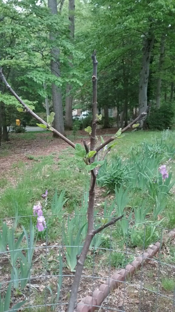
Dormant fig starting to leaf out. Found a similar picture from April 16 of last year. It's about 3 weeks later this year. We insulate with shredded leaves (mostly) in winter. Just planted in 2020, so don't have any other data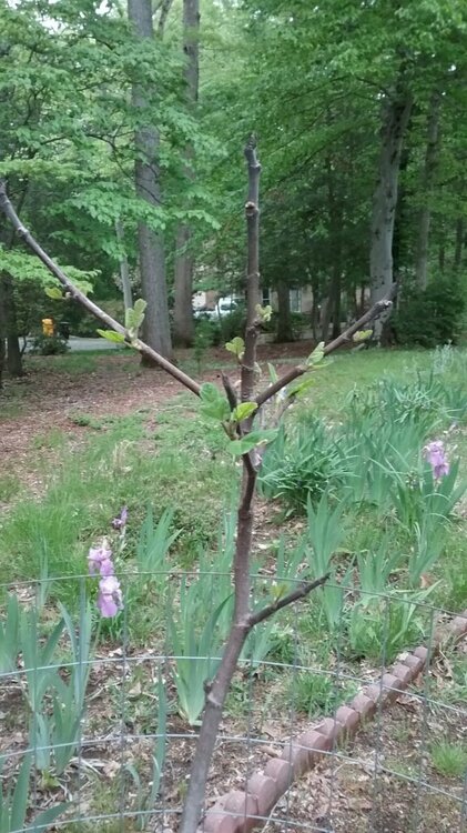
- 137 replies
-
- 5
-

-
- maters
- green stuff
- (and 5 more)
-
Congratulations, and may God bless your union.
-
Summer max contest -- final results posted
GramaxRefugee replied to Roger Smith's topic in Mid Atlantic
DCA: 99 IAD: 100 BWI: 101 RIC: 100 -
Looks like that 33f was set in 1874. Pretty cool. AAFB min 31f. (and 10 miles west of there, DCA lands at 42f)
-
Low of 31f No scraping though. quite clear