

Stormchaserchuck1
-
Posts
4,952 -
Joined
-
Last visited
Content Type
Profiles
Blogs
Forums
American Weather
Media Demo
Store
Gallery
Everything posted by Stormchaserchuck1
-

Jan Medium/Long Range Disco 2: Total Obliteration is Coming
Stormchaserchuck1 replied to Jebman's topic in Mid Atlantic
Following February's from those analogs look like seasonal models currently have https://ibb.co/K6mtPwr Globe is a little too cold biased for my liking, and the GOA low has been missing so far in this El Nino. Maybe D+8 model will shift a little bit. -
Jan Medium/Long Range Disco 2: Total Obliteration is Coming
Stormchaserchuck1 replied to Jebman's topic in Mid Atlantic
Yeah, if that block can hold over Alaska, and close off a strong low underneath of it, downstream wave should be able to pick up energy from the gulf.. we're almost there. Still a little ways to go -
Jan Medium/Long Range Disco 2: Total Obliteration is Coming
Stormchaserchuck1 replied to Jebman's topic in Mid Atlantic
CPC is going with below average precip right now https://ibb.co/Zg7hQs7 -
Jan Medium/Long Range Disco 2: Total Obliteration is Coming
Stormchaserchuck1 replied to Jebman's topic in Mid Atlantic
I am interested to see if +PNA holds if we go back to -NAO past 15D.. -
Jan Medium/Long Range Disco 2: Total Obliteration is Coming
Stormchaserchuck1 replied to Jebman's topic in Mid Atlantic
Stratosphere warming should hit be hitting a favorable -NAO correlation time around then, too. It's like +80-120dm on the mean at +20-25 days. -
Jan Medium/Long Range Disco 2: Total Obliteration is Coming
Stormchaserchuck1 replied to Jebman's topic in Mid Atlantic
Initial trough is further SW on 18z NAM 84hr vs 12z GFS 90hr https://ibb.co/6bV088Y -
Jan Medium/Long Range Disco 2: Total Obliteration is Coming
Stormchaserchuck1 replied to Jebman's topic in Mid Atlantic
I guess we are chipping away at the PDO. I was never a believer in PDO being a leading indicator, but this Winter sure has made a case. I think we are up to -0.6 and still having a tendency to rise, so maybe a more organized +PNA can get going here in the next few weeks. It's also amazing how these El Nino constants hold (warm Dec, good 2nd half of Winter). Let's see if the +PNA can hold through February, because we are coming off the most powerful 6-year constant on record (-PNA) for February ('18-23) -
Jan Medium/Long Range Disco 2: Total Obliteration is Coming
Stormchaserchuck1 replied to Jebman's topic in Mid Atlantic
00z NAM much different than 18z GFS at 84hr https://ibb.co/C1W8QQQ -
Jan Medium/Long Range Disco 2: Total Obliteration is Coming
Stormchaserchuck1 replied to Jebman's topic in Mid Atlantic
I would have told you it's wet.. It's Global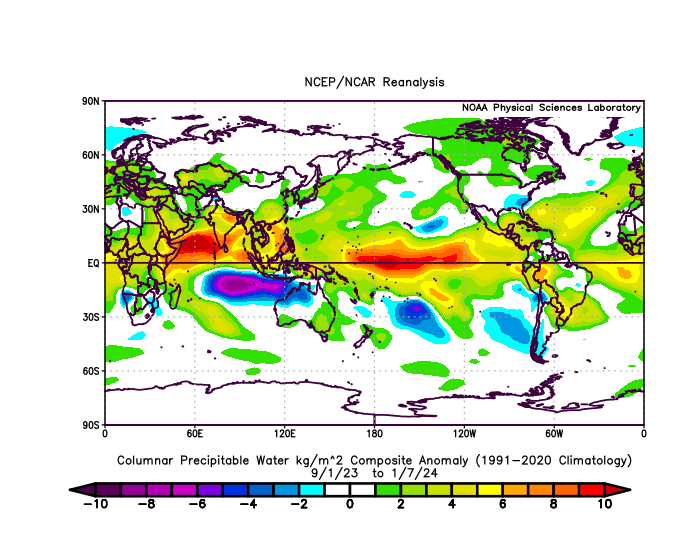
-
Jan Medium/Long Range Disco 2: Total Obliteration is Coming
Stormchaserchuck1 replied to Jebman's topic in Mid Atlantic
I like the long range.. ridge builds off the west coast, PNA goes positive.. this positive PNA evolution is fitting exactly the 15 analogs I came up with that had a -PNA Jan 5-13, during an El Nino or Neutral ENSO. I thought it was telling, because in roll forwards you usually see the same variable smoothed out, but it gave me a reversal to -100-120dm Aleutian low and 80dm -epo by Jan 25th. Now look at what's happening when all this positive change is happening on the model... The NAO is +. And it looks like a 2std positive event with -200dm on the D14-15 ensemble mean. I was telling PSUhoffman that, that is what we need right now to flip to a favorable pattern in the Pacific and probably on the west coast.. let's hope these probabilities hold as we go into the last week of January. -
Jan Medium/Long Range Disco: Winter is coming
Stormchaserchuck1 replied to stormtracker's topic in Mid Atlantic
Problem is that 970s/980s mb low in SE Canada. Not going to cool down enough if that happens. -
Jan Medium/Long Range Disco: Winter is coming
Stormchaserchuck1 replied to stormtracker's topic in Mid Atlantic
Yeah, 970s mb low in the Hudson Bay with no High around it could make for a warmer pattern even if the track is good -
El Nino 2023-2024
Stormchaserchuck1 replied to George001's topic in Weather Forecasting and Discussion
In September 2022, the AMO shattered records hitting +0.662 for the month. 2nd place was -0.536 in 1974 and +0.505 was the 2nd highest monthly positive reading. +15 months you see a good +WPO signal for December 2023: https://ibb.co/WKN16kw Which is also kind of a now-time +AMO indicator https://ibb.co/0qpS3t4 Feb posts a SE ridge, which is something I'm watching out for this year, as the mean of the last 6 February's in the PNA region has been +150dm (record). It will be interesting to see if that or the El Nino wins out this year. https://ibb.co/hs8h0T5 -
El Nino 2023-2024
Stormchaserchuck1 replied to George001's topic in Weather Forecasting and Discussion
The PNA has a really strong correlation to warmth in the east in January.. >0.5 https://ibb.co/rZ5HkST We just haven't been timing it right.. we got +pna in December when the correlation was 0.1, then on Jan 1-2 the pattern changed. -
El Nino 2023-2024
Stormchaserchuck1 replied to George001's topic in Weather Forecasting and Discussion
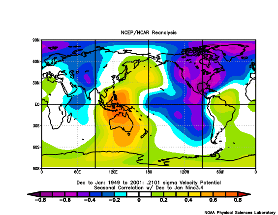
I mean.. that's some pretty incredible stuff. +VP at the dateline is +PNA, but El Nino is associated with -VP at the dateline.. We all know the strong ENSO/N. Pacific correlation.. -
El Nino 2023-2024
Stormchaserchuck1 replied to George001's topic in Weather Forecasting and Discussion
Yeah.. you're right [default positive] Counter intuitive to what you would expect in El Nino I guess the relative difference is a strong indicator.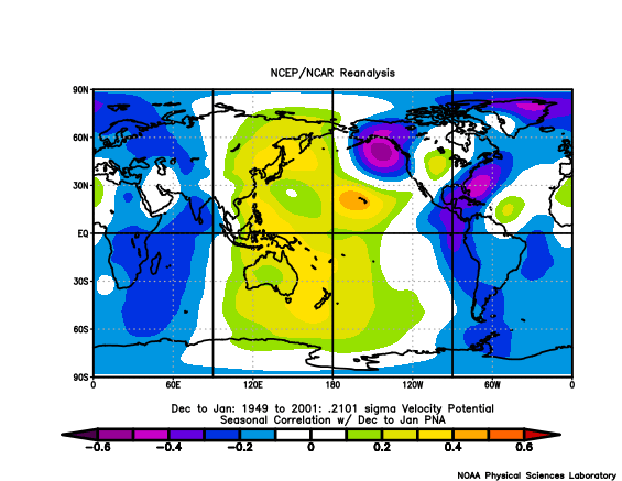
-
El Nino 2023-2024
Stormchaserchuck1 replied to George001's topic in Weather Forecasting and Discussion
I don't know.. east-based, west-based doesn't really account for the -PNA pattern we have seen so far. East-based most impacts the NPH (North Pacific High) https://ibb.co/bR7r8Fv and we haven't really seen any signs of that so far. I think even going into February, a +PNA would be more likely than a GOA low (-NPH pattern). It just hasn't really been building. -
No shortage of precipitable water right now in the N. Hemisphere https://ibb.co/L6PLQdc https://ibb.co/WpVDLKn
-
Thanks. Globe has been really wet the last 4 months too. https://ibb.co/WpVDLKn
-
Looks like it's about 0.3 https://ibb.co/P4sqQf5 (barely above 0.0 in March)
-
-PNA has a strong correlation to precip. >0.5 in January https://ibb.co/ZhPJnV9 -PNA in El Nino, especially Strong El Nino.. really wet combo there
-
Jaleen Hurts had won 25/26 for a while there.. It was making me a little mad because I didn't think they did anything special, although you see how having a scrambling QB really ups the odds.
-
Jan Medium/Long Range Disco: Winter is coming
Stormchaserchuck1 replied to stormtracker's topic in Mid Atlantic
model error/biases are worth pointing out -
Jan Medium/Long Range Disco: Winter is coming
Stormchaserchuck1 replied to stormtracker's topic in Mid Atlantic
Watching SE Canada pressure https://ibb.co/tC5bQQN -
Jan Medium/Long Range Disco: Winter is coming
Stormchaserchuck1 replied to stormtracker's topic in Mid Atlantic
Block over the Aleutian islands now. A few days ago, it was Alaska. Hard not to get a little SE ridge with that in January. But there is a ridge in the WC, so maybe it can dampen the wave.


