

TheClimateChanger
-
Posts
4,598 -
Joined
-
Last visited
Content Type
Profiles
Blogs
Forums
American Weather
Media Demo
Store
Gallery
Everything posted by TheClimateChanger
-
Central Pa. Summer 2024
TheClimateChanger replied to mahantango#1's topic in Upstate New York/Pennsylvania
Lots of red and brown out there. Just the way it ought to be in July. Even East Nantmeal might manage a couple of 90s. -
Pittsburgh, Pa Summer 2024 Thread.
TheClimateChanger replied to meatwad's topic in Upstate New York/Pennsylvania
Looking solid. -
Pittsburgh, Pa Summer 2024 Thread.
TheClimateChanger replied to meatwad's topic in Upstate New York/Pennsylvania
Should be able to reach 90 or 91. It’s already reached 87 or 88, and it’s quite a bit brighter than yesterday when it reached 89F. Still variable cloud cover, so one of those days if you get an extended intrahour sunny interval, it can shoot up a couple degrees then drop back. -
Mount Washington Weather Archives - Mount Washington Observatory All the same extremes back to 1933, on the observatory archive.
-
xMacis only has the observations dating back to 1948. Not sure if anything higher was recorded prior to 1948.
-
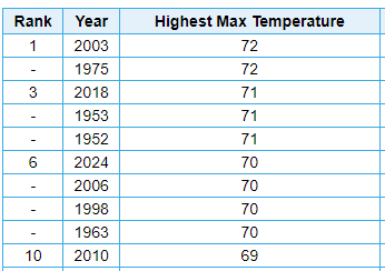
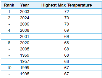
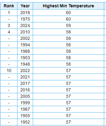
Maximum of 70F yesterday at Mount Washington. 2 below the highest of record in June and all-time, since 1948. June All-time The minimum of 59F on the 18th was the highest of record since 1948 in the month of June and 1F below the all-time maximum. The minimum of 58F yesterday would have matched the previous monthly high. June All-time

-
Pittsburgh, Pa Summer 2024 Thread.
TheClimateChanger replied to meatwad's topic in Upstate New York/Pennsylvania
While the current warm spell may have been a bit of a letdown thus far, it does appear increasingly likely that we see the warmest June on record at Pittsburgh International Airport, and a top ten warmest June in the threaded record. The number to beat at the current location is 73.0F from 1967. To get into the top ten overall, we would need a mean of 73.3F. There is a decent chance that it will be our warmest June overall since 1943, when the mean temperature was 74.5F. I estimate the mean should increase to around 72.9F through the 26th (based on current forecast) with continued warmer than normal weather likely thereafter. -
Your car thermometer sensor is like a foot or so above black asphalt. I’m assuming that has more to do with this observation than “urban heat island” effect.
-
Pittsburgh, Pa Summer 2024 Thread.
TheClimateChanger replied to meatwad's topic in Upstate New York/Pennsylvania
-
Pittsburgh, Pa Summer 2024 Thread.
TheClimateChanger replied to meatwad's topic in Upstate New York/Pennsylvania
Looks like we’re going to be 89’d again like Sunday. Meanwhile, an all-time record of 96F in Caribou, Maine. Add northern Maine to the list of places that do heat better than Pittsburgh. -
Pittsburgh, Pa Summer 2024 Thread.
TheClimateChanger replied to meatwad's topic in Upstate New York/Pennsylvania
Yes, albeit many of the other local sites have reached 100+ due to slightly higher dewpoints. Almost impossible to reach official EHW criteria in the month of June at the airport. Only happened once since 1945 - June 27, 1978. The high that day was "only" 93F, so dewpoint readings must have been in the upper 70s to get that high of a heat index. Didn't even reach 105+ during 1994 or 1988, as humidity was relatively modest. I suspect NWS upgraded to EHW just due to duration and recognizing some of the lower elevation locations and the city probably have heat indices 2 or 3F warmer than the official values. Maybe we get closer later in the week or on Saturday. -
Pittsburgh, Pa Summer 2024 Thread.
TheClimateChanger replied to meatwad's topic in Upstate New York/Pennsylvania
The official temperature is taken to the nearest tenth of a degree in Celsius, and then converted to Fahrenheit (and rounded to nearest whole degree). The five minute observations read only to the nearest whole degree Celsius before the conversion, so due to rounding it can often be +/- 1F of what is shown. On sky cover, the METAR is augmented by a contract observer. The ASOS ceilorometer (sp?) only reports cloud cover at or below 12,000 feet. If the cloud deck is above that level, as it is this morning, the ASOS will report clear skies (which really only means clear skies below 12,000 feet). Also sometimes, it can miss some isolated lower clouds so you might see the ASOS report clear when it really should be something like FEW040 (a few clouds at 4,000 feet). None of the other ASOS or AWOS sites are augmented, so that's why PIT will often report much more substantial cloud cover than the other smaller local airports. -
Pittsburgh, Pa Summer 2024 Thread.
TheClimateChanger replied to meatwad's topic in Upstate New York/Pennsylvania
Quite cloudy and hazy today. Probably going to be a slower climb today. Should still reach 90+ with the high starting point. -
Pittsburgh, Pa Summer 2024 Thread.
TheClimateChanger replied to meatwad's topic in Upstate New York/Pennsylvania
I don’t think we do it. Tomorrow looks subtly cooler aloft. Probably 91 or 92. Maybe Thursday to Saturday, which looks warmer. Might manage an official 95 or 96 during that stretch. -
Central Pa. Summer 2024
TheClimateChanger replied to mahantango#1's topic in Upstate New York/Pennsylvania
Inside? What is it inside? A greenhouse? -
Pittsburgh, Pa Summer 2024 Thread.
TheClimateChanger replied to meatwad's topic in Upstate New York/Pennsylvania
High was at least 92 at KPIT. Probably 93 or 94, based on 5 minute data. Multiple observations of 34C/93F, but that could be between 33.5C and 34.4C [92.3-93.9F]. -
Central Pa. Summer 2024
TheClimateChanger replied to mahantango#1's topic in Upstate New York/Pennsylvania
Bradford reached at least 90F today, marking only the third time it has reached at least 90F in the month of June since records began in 1957. The other two occasions were both in 2022: 90F on the 16th; and 93F on the 22nd. -
Central Pa. Summer 2024
TheClimateChanger replied to mahantango#1's topic in Upstate New York/Pennsylvania
Wow, international! It's been upgraded? Where are they flying to internationally? -
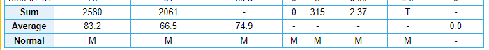
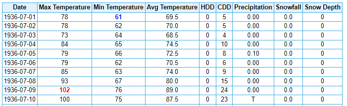
Anyways, I wouldn't get too worked up over one reading from 1936. The same people who blab on about "it's only summer" and cry about the shading color of the weather map would be saying the same thing about that summer. And, to be quite honest, I think they would have a point. They say it's the hottest summer on record, but this looks like a summer of yesteryear to me (outside of a 1-week hot stretch). June 1936 Central Park Weather Bureau Office July 1936 Central Park Note: Excluding the 7 days from July 8 to July 14, the means are 83.1F/64.5F and 73.8F average for the other 24 days. Weather Bureau Office August 1936 Central Park Weather Bureau Office


-
Very sketchy reading. Why was it 4F warmer in the park than at the Weather Bureau office in the city that day? Weird, the opposite of what you would expect from the UHI effect. It's also weird that they give precedence to the park's readings over the Weather Bureau readings. Very atypical, as most threaded records utilize the WB office readings.
-
June 16th-21st (and beyond?) Heatwave
TheClimateChanger replied to Geoboy645's topic in Lakes/Ohio Valley
They really need to switch to wet bulb globe temperature, or some other measure of heat. Weird look when you have one of the hottest June days on record, and not even an advisory. LOT used to be much more diligent about getting the warnings out for the urban heat island.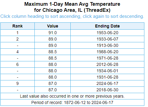
-
June 16th-21st (and beyond?) Heatwave
TheClimateChanger replied to Geoboy645's topic in Lakes/Ohio Valley
5-minute observation up to 93F before 11 am, per the ASOS at Burke Lakefront Airport in Cleveland.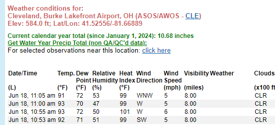
-
Pittsburgh, Pa Summer 2024 Thread.
TheClimateChanger replied to meatwad's topic in Upstate New York/Pennsylvania
From a station serving Steubenville, Ohio & northern West Virginia, but sharing as I thought this was a nice regional map of high temperatures from yesterday. Impressed by the 89 in Johnstown - the airport is at close to 2300 feet, I believe. -
Central Pa. Summer 2024
TheClimateChanger replied to mahantango#1's topic in Upstate New York/Pennsylvania
It was also the third earliest 90+ reading since records began in 1962. It was 91F on June 2, 2023, and 90F on June 8, 1968. -
Pittsburgh, Pa Summer 2024 Thread.
TheClimateChanger replied to meatwad's topic in Upstate New York/Pennsylvania
Looking pretty solid for some classic summer heat right into mid July. Not sure if we’ll see anything as warm as the current stretch (relative to average) but CPC seems pretty confident of continued above normal temperatures.


