TheClimateChanger
-
Posts
4,388 -
Joined
-
Last visited
Content Type
Profiles
Blogs
Forums
American Weather
Media Demo
Store
Gallery
Everything posted by TheClimateChanger
-
Winter 2024-25 Medium/Long Range Discussion
TheClimateChanger replied to michsnowfreak's topic in Lakes/Ohio Valley
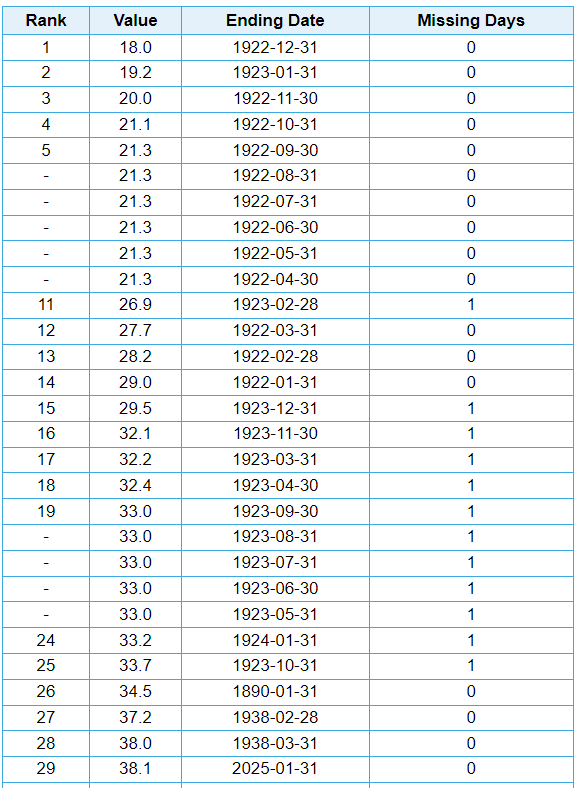
Here is another good way to view the recent snow drought in Chicago. We can see the 24-month period ending January 31st was the least snowy 24 months since the 24-month period ending March 30, 1938! The exact ranking on this metric isn't super important, since these are not independent values - that is, any month will share 23 of the 24 months with the preceding and following month. And during the warm season, the values are static, since a month with no snow simply replaces a month with no snow two years earlier.
-
Pittsburgh/Western PA Winter 2024-2025 Thread
TheClimateChanger replied to Rd9108's topic in Upstate New York/Pennsylvania
Get a load of this screw zone. -
Now this is what I call winter. Looks glorious.
-
Chicago Weather Records Tracking
TheClimateChanger replied to Chicago Storm's topic in Lakes/Ohio Valley
Interestingly - maybe not to others, but I like data - of the 13 years with the least snow through February 7, only 4 ended up among the top 10 least snowy (1920-1921, 1921-1921, 1936-1937, and 1912-1913). The top 3 least snowy overall, which is probably not super surprising, as these are years with little snowfall through early February that also had little snowfall thereafter, and then just one other (1912-1913, tied for 8th place). All of them, however, finished with less than the current seasonal normal of 38.2 inches. As noted, 2012-2013 had a decent turnaround, but the strongest turnaround was the winter of 1963-1964, which, despite just 10.4 inches through today's date, finished with 35.2 inches on the season. I suppose it's not too surprising that all of these winters finished below the seasonal normal. It would take one of the snowiest late season periods on record for 2024-2025 to reach the seasonal normal (and that, of course, would be true for all of those years). This year, for instance, 28.3" would have to fall from tomorrow through the end of the season to reach the normal seasonal snow - that figure has only been reached 4 times and not since 1970.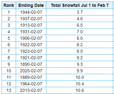
-
Chicago Weather Records Tracking
TheClimateChanger replied to Chicago Storm's topic in Lakes/Ohio Valley
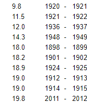
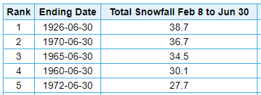
These are the least snowy years officially through February 7... projecting, of course, no measurable snowfall today. And eliminating a couple of incomplete winters, including 1997-1998, which, for some reason, does not include snowfall that fell after December 31 in Chicago. The NWS Chicago office has the correct seasonal total for that winter. Probably a moot point, because it looks likely that this season will again surpass the running tally from 2012-2013 within the next several days. That winter actually didn't finish too poorly, with seasonal snowfall finishing at 30.1 inches. But certainly, it got off to a very rough start, especially coming off of one of the least snowy winters on record the prior year. The 10 lowest final seasonal totals are given below. Of these 10, all but 3 were observed when the official weather station was downtown. In 1936-37, the official observations come from the University of Chicago; in 1948-1949, from Midway Airport; and in 2011-12, from O'Hare Airport. Source: Chicago, IL Seasonal Snowfall Totals from 1884 to present!
-
Chicago Weather Records Tracking
TheClimateChanger replied to Chicago Storm's topic in Lakes/Ohio Valley
Don’t be dense. They were obviously carrying it through today with no snow expected. The claim is true through today’s date. It should have stated that was projected through the 7th, although that context was probably provided on air or on the web where this X account pulled the graphic. -
Arctic Sea Ice Extent, Area, and Volume
TheClimateChanger replied to ORH_wxman's topic in Climate Change
Yikes! -
Fall/Winter '24 Banter and Complaints Go Here
TheClimateChanger replied to IWXwx's topic in Lakes/Ohio Valley
You don't even have to go back that far. 1961-1990 normal was even lower. Even as recently as 2010, this January would have been considered +0.6F. They've really jacked up the January normal mean in the last two decades at O'Hare. If it rises another 0.8F for 2001-2030, that would be a full 5F rise from 1961-1990. 1951-1980: 21.4F 1961-1990: 21.0F 1971-2000: 22.0F 1981-2010: 23.8F 1991-2020: 25.2F For comparison, Rockford (RFD) has gone from 18.2F for 1961-1990, to 21.8F for 1991-2020, a rise of 3.6F versus ORD's rise of 4.2F. Interestingly, the normal January mean at RFD is higher than it was for ORD in 1951-1980 & 1961-1990, and just a touch below 1971-2000. -
Pittsburgh/Western PA Winter 2024-2025 Thread
TheClimateChanger replied to Rd9108's topic in Upstate New York/Pennsylvania
-
Instead, it seems to me that biggest drivers of earth's climate, after carbon dioxide, are Milankovitch cycles. These can explain the relative warmth of the Holocene Thermal Maximum and can also explain the gradual cooling trend that has been ongoing for the past several thousand years. In the absence of warming, a new glacial period would likely naturally occur in thousands of years.
-
As a follow-up, this is why I have grown increasingly skeptical of natural variation. (1) The Medieval Warm Period, Little Ice Age and Roman Warm Periods were made up between the 1950s & 1970s. Prior to this time, the overwhelming view was that there had been little significant variation during the historical time (i.e., since roughly 1-2k years before Christ). Of particular note, the scientists living during the so-called Little Ice Age did not believe they were living in a little ice age. In fact, considering the same evidence offered in support of these variations, they did NOT find any compelling reason to conclude a significant change in climate had occurred. More importantly, and this is a big point, the modern GLOBAL reconstructions appear to be largely consistent with the prior view. There appears to be little evidence to support the contention that any of these periods were significant deviations from a general long-term cooling trend. Comically, the so-called "Roman Warm Period" was previously theorized to be a "Roman Cold Period." This older line of belief stemmed from the observation that the height of global development was in northwest Europe and had shifted north with time from the Mediterranean. Thus, there was a belief that the Roman era was somewhat colder (or at least wetter) with a suppressed storm track that would have led to more favorable conditions for widespread agriculture. Conversely, in this theorized colder regime, the conditions in the north and west of Europe would have been colder and less suitable for agriculture, industry and civilizational development. Now, we're simply told by grifters that society always advances during periods of warmth, and warmth is good. I mean, really? While I don't have reason to doubt the current view, which of these two claims about the development of ancient Rome intuitively makes more sense? (2) The Maunder Minimum, and the concept of grand solar minima, was made up in 1976. For hundreds of years, nobody suggested there was a multi-decadal period with little or no sunspots or solar activity. Scientists from the 1800s and early 1900s, who had previously looked at the same record, concluded that the records before about the middle of the 18th century were incomplete and had worked tirelessly to create an accurate reconstruction of solar activity that extended back to the invention of the telescope. Dr. Rupert Wolf's efforts were thrown by the wayside, in favor of this shocking claim of no sunspot activity. We now have approximately about 275 years of reliable sunspot records, and there has never been a grand solar minimum observed. My question to proponents of the grand solar minimum is - how much longer do we need to observe the sun without a grand solar minimum before we start to question whether there really is such a thing (or, at least, in the sense that the terminology is commonly used today). Dr. Eddy, who described the Maunder Minimum, had deep ties to the U.S. military, and was not highly regarded by his peers at the time. His ties to the U.S. military certainly provide a compelling reason to create a new history of the sun/earth's climate. And, since the United States dominates this field, this is the only view you get to hear. Here is a fairly recent Russian paper with a different conclusion: The Maunder Minimum Is Not as Grand as It Seemed to Be, Zolotova and Ponyavin, 2015. Link: THE MAUNDER MINIMUM IS NOT AS GRAND AS IT SEEMED TO BE - IOPscience (3) The supposed link between solar minima and cooling temperatures. The exact opposite was believed for hundreds of years. They even quantified the change in temperature during the solar cycle. So, it seems hard to believe that this would have been incorrect? If you look it up, you might see the suggestion that this was because the scientists incorrectly believed that the dark spots resulted in less TSI. But this is incorrect, it was known that total solar irradiance was somewhat higher, which they considered to be a conundrum, which was resolved by the theory that, in essence, EEPs emitted from the sun could deplete stratospheric ozone, promote changes in cloudiness/storminess by acting as cloud condensation nuclei, and could impact atmospheric and oceanic circulations in ways that would promote arctic outbreaks into the middle latitudes. Today, all of these are now said to be linked to galactic cosmic rays which are said to occur with much greater frequency during solar minimum. If you look up old climate texts, you can actually see where it was previously theorized that something akin to a "grand solar maximum" could potentially lead to a new Ice Age. Make it make sense.
-
I think we need to trust the process. There's no evidence of Elon deleting data, or any of these salacious claims. But I'm going to disagree, former heads of NOAA/NWS and employee scientists spent decades DOWNPLAYING climate change and making false or misleading statements about human impacts. They need to be held accountable for their actions. Even today, NOAA continues to publish misleading US climate statistics. If the data were properly homogenized and adjusted for non-climatic biases, the warming trend in the US would probably be twice the published rate (or even more). Many of the published state and national temperature records were not observed in a manner consistent with current observational standards. Regarding climate, there is an overwhelming amount of evidence of carbon dioxide's role in climate change - whether natural or through manmade emissions of the gas. If anything, I guess I would characterize myself as more of a "natural variability" skeptic. Yes, there's natural variability as I acknowledge but it seems to have minimal impact on the trend. In fact, most reasonable reconstructions seem to suggest a very gradual, long-term cooling trend from the Holocene Thermal Maximum which occurred from between 6-8k years ago. There seems to be little evidence of a significant Roman Warm Period, Medieval Warm Period, or Little Ice Age, except for the fact that the latter is indeed, likely, the coldest period since the recovery from the Younger Dryas. But this is more indicative of the gradual cooling trend that had largely been in motion since the Holocene Thermal Maximum. IMHO, it is likely that this cooling trend would have persisted resulting in the commencement of a new glacial period in the next 10-20k years, or sooner. If we go back further in time, past the Holocene Thermal Maximum, we reach the Younger Dryas around 11.7k years before the present and lasting for about 1,000 years. Further back in time is a brief "warmer" interlude between the Younger Dryas and the core of the last glacial period, which reached its maximum extent around 20-25k years before the present. However, this glacial period commenced around 120-125k years before the present. During the Pleistocene, which commenced 2.58 million years before the present, there have been repeated glacial advances and retreats. Some of these interglacial periods were perhaps warmer than the present by some degree, but that's about it. We are firmly on course for a Pliocene climate and will way overshoot that. This ought to be undeniable.
-
Pittsburgh/Western PA Winter 2024-2025 Thread
TheClimateChanger replied to Rd9108's topic in Upstate New York/Pennsylvania
Doesn't look like it should be too big of a threat. I know we had an ice storm back in 2021 or 2022, where we lost power for 16 hours, but the temperatures there only climbed to like 33-35F. This event has unbelievably warm air advecting in, with temperatures likely to climb well into the 50s on Thursday, maybe even some 60F readings south of PIT. This sounds a little ominous for Saturday night, though. Heavy rain and 32F. I wonder if there will be some more freezing rain in the area.
-
Hey, if it's not going to snow, might as well climb well into the 60s!
-
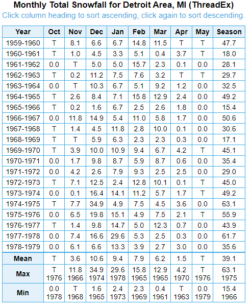
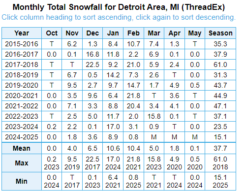
Historically, Detroit has been a horrible city for snow. In decades past, even the lower elevations of southern West Virginia used to receive as much snowfall as Detroit. Unfortunately, climate change has destroyed seasonal snowfall in the south, so this is no longer true.
-
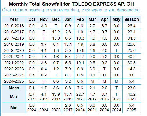
Yes, a good way to compare this is to simply look at the data. I like to call that part of Michigan, the "banana belt" of Michigan. Despite the record-breaking snowfall drought at Cleveland over the past 10 years, snowfall at Detroit has averaged only 0.8"/year more. It's taken an unprecedented drop in snow at Cleveland for Detroit to have a competitive snowfall decade. That should tell you enough about which of these cities has a superior snowfall climate. Even worse as you head south towards the Ohio line, including places like Temperance & Monroe, as shown by the data from Toledo Express Airport over that interval.
-
What I think is going on, and I don't say this lightly, is the climate has warmed so much already that typical weather events now seem unusual. Possibly even among people who accept the reality of global warming. I frequently see people claiming - without evidence, I might add - that global warming is actually leading to colder winter extremes, and wavier jet streams, and other similar nonsense. It's like these people have never looked at any historical weather records in their life. This is natural variability leading to regional cooling amidst a much, much warmer global climate. In colder past climates, there has been far colder weather. And snow was much more frequent along the Gulf of America (formerly known as the Gulf of Mexico) coast in the past than it is today.
-
A couple of examples, not even pointing to deniers, who deliberately do this. I saw a Univision meteorologist make a post on X showing a large chunk of the eastern United States as having a top 5 coldest January, including locations like Indianapolis and Miami. While the post did not label it as such, these appear to have been 21st century rankings. In fact, it was only the 36th coldest January on record at Indianapolis [and tied with 1962]. At Miami, it was the 43rd coldest January on record. It was, indeed, the 4th coldest January on record at Miami and Indianapolis, since 2000. Put in proper perspective, from 1896-1987, there were 39 colder Januarys at Miami! From 1875-1994, there were 33 Januarys as cold or colder than this one! That's a recurrence interval of only a bit fewer than 1 out of 2 years at Miami, and around 1 out of every 3.6 years at Indy, for those time periods [which encompass the late 19th century and the vast majority of the 20th century]. Not at all notable based on historical data. Another example... I saw the NWS Pittsburgh office share this on X. While it claims the data dates to 1871, in fact, snowfall depth data at Pittsburgh is only available since 1948. This means there have been 26 stretches with snowcover as long or longer than the stretch that recently ended during the preceding 77 years. That's more than 1 in every 3 years, so actually pretty typical. And, in fact, in not for the recent dearth of snow cover, the true incidence would be somewhat more frequent than implied by the full data. Also, some of those years in the 1970s & 1980s literally saw months of nonstop snowpack. It's also worth pointing out that snowfall observations are now taken in a shady, suburban office, which would be much more conducive to retention of snowpack than an open airfield with lots of tarmac. This suggests that there probably would have been even more streaks of a similar length if observations were taken at the same site. I don't know who needs to hear this, but there are supposed to be periods where snow lingers for weeks in a Pittsburgh winter. It's not at all unusual or noteworthy.
-
Maybe it's just me, but this seems emblematic of a bigger problem I see when it comes to cold temperatures and snowfall. There seems to be a push to exaggerate the importance of cold temperatures and/or snowfall, even when, from a historical perspective, they are normal conditions. Even model projections! I see people posting very long-range model projections of snow - 16 days, or even longer periods of 30+ days - and saying they've never seen such amounts of snow! I feel like I'm in bizarro world. Models do this all the time. Hell, there have been numerous periods where more snow than shown in those "unbelievable" projections actually fell! Not saying they are going to be right, but there have been, like, actual periods that were actually snowier than most of these maps I'm seeing.
-
On this point, I think it's worth noting that much hullabaloo has been made about this allegedly being the coldest January since 1988. We will have to wait and see what the NCEI numbers are, but UAH does not agree. Also, January 1988 is only the 24th coldest on record for the CONUS, so it's not notable at all. Even if this were to turn out to be the coldest January since 1988 for the CONUS, it's important to place this finding in perspective. From 1895-1988 - a period of 94 years - 24 years would have been colder than this January. In a typical 20th century climate, this means, on average, more than 1 out of every 4 Januarys would be expected to be colder than this one. And it's worth pointing out that the 20th century, from which this data is drawn, is widely regarded as being the warmest century in North America since the arrival of Europeans. While somewhat colder than the mean, this January was not atypically cold for the CONUS as a whole.
-
UAH is in and shows a pretty steep decline, albeit still a warm month. Not sure how much stock to place in their estimates. All adjustments ever made always seem to be downward! Their estimate for USA48 was -1.06C, making this the coldest January for USA48 since 2008.
-
I actually prefer the moniker, "The Best Location in the Nation. Cleveland, Ohio" as the great Bruce Kalinowski, then going by the name, Bruce Edwards, to survive in a vehemently anti-ethnic South, used to say. Bruce being well known from his days on The Weather Channel. Indeed, he was the live meteorologist for The Weather Channel's first ever broadcast way back in 1982.
-
Here is a live simulcast of the Zoom discussion on these findings:
-
-
Nice taste of spring today in the Ohio Valley, with some record highs being met or exceeded. Enjoy the warmth because it might be short-lived. I believe this is what they call "false spring" in these parts. As of the top of the hour, Columbus, Ohio was up to 63F, tying the record set on this date in 2020 and 1890; Dayton, Ohio was up to 65F, beating the prior record of 62F set in 2020 and 1927; Cincinnati, Ohio was up to 66F, tying the record set in 1883; Indianapolis, Indiana was up to 67F, tying the record set in 2020; South Bend, Indiana was up to 55F, tying the record set in 2020; Evansville, Indiana was up to 72F, breaking the record of 70F set in 2020; Paducah, Kentucky was up to 71F, tying the record set in 2020; Jackson, Kentucy was up to 70F, breaking the record of 69F set in 2020; and Lexington, Kentucky was up to 71F, breaking the record of 70F set in 1890. The temperature at Louisville stood at 73F, one shy of the 2020 record value. Any other record reports out there?