George001
-
Posts
6,887 -
Joined
-
Last visited
Content Type
Profiles
Blogs
Forums
American Weather
Media Demo
Store
Gallery
Everything posted by George001
-
Euro whiffs with the first storm but looks great for the 2nd one on the 13th. I’m interested to see what the EPS says.
-
Though I wouldn’t mind seeing the epic pattern delay a couple more weeks, that would mean my area has a better shot in the early part of the pattern as well as later on.
-
That’s not really true, the models have been going back and forth but the H5 looks great on the ensembles for the 13th threat. There are a lot of indies taking the low down to the 970s and some to the 960s. The interior is favored for that one, but if the low gets that deep the coast could get a lot of snow as well. I agree that the 3rd week to 4th week is when the coast will start having better chances though.
-
Yeah the polar vortex splitting isn’t always good for us, it can actually be bad. A couple years ago the polar vortex split to the wrong side of the globe and we had a really mild winter (2020 I think it was). I read that this year is expected to be a weak polar vortex based on the latest guidance, but no polar vortex split. I don’t even think this polar vortex event is expected to be an official SSW, just a bunch of smaller disruptions to the polar vortex instead which can be just as good.
-
Yeah, the models have been going back and forth on the starting date of the pattern change. I haven’t really noticed a delay, it moved from the 13th to the 10th and back to the 13th again on the ensembles. Even if it does get delayed a bit more on the models it’s not a big deal, and if anything those of us closer to the coast should be rooting for a delay to like the 20th or so.
-
That’s right. Lows don’t ram into massive blocks like this one.
-
Yeah there’s no reason to worry. As long as there is blocking it will snow. Not every threat will work out but we will have enough chances that the odds of us making it out of December without at least one big storm is very low.
-
Fair point, but this isn’t a run of the mill -NAO either. Also, the Feb 2018 SE ridge was even stronger than this one. Temps got up to 80 in Feb, yet the blocking still beat it down some. It took time, like this one probably will. That’s why the first 10 days or so of December are expected to be mild, and the first storm is lower probability than the latter 2 over the next couple of weeks.
-
I might stop by, I’m not sure yet though. I’ll have to check my schedule to see if I can make it or not.
-
We want the SE ridge to prevent suppression. We don’t need help with the PNA, it can snow with a negative PNA and it can snow a lot. December 2010 had a trough out west as well.
-
I don’t agree that the chances are lower for the first 2 systems, the ensembles have a lot of hits. OP runs are still useless. If anything the chances for the 2nd system has increased.
-
The ensembles still have a signal. Nothing has changed, 1st threat 10-11th, 2nd threat 13-14th, 3rd threat 17-20th. The later threats are more likely to produce than the earlier ones, but all of them have a chance.
-
We don’t need the pacific to be good when the blocking is this strong. The blocking will prevent storms from cutting.
-
I think the new upgrade made the gfs worse. It used to be ok a few years ago, but with every upgrade it gets worse and worse. The gap between the Euro and GFS has only widened, and the Canadian surpassed the GFS a few years ago as well.
-
The block isn’t going to just disappear, and nothing has been pushed back. The 1st threat is the 10th, 2nd the 13-14th, 3rd 17-20th timeframe. OP runs are useless this far out. They are fun to look at dont get me wrong, but it’s important to take what they say with a grain of salt, good or bad. Besides they don’t even look bad, the Canadian is gearing up a Miller B at the end of the run.
-
Canadian is gearing up a Miller B at the end of the run
-
I don’t get why people are saying we are kicking the can. The EPS has a great signal for the 12-13th. Some of the indies take the low into the 970s and 960s. Even if we do kick the can a bit it’s really not a big deal.
-
That isn’t possible. Blocking suppresses the SE ridge, what we are seeing is the SE ridge already in place, that’s why the blocking and SE ridge look like they are linked up initially. That’s the beginning of the pattern change, the SE ridge gets beaten down some, not completely but enough for NYC north. In Dec 2010 we had a negative NAO and negative PNA.
-

My Winter Outlook for 2022-23
George001 replied to raindancewx's topic in Weather Forecasting and Discussion
Didn’t December 2010 have a cold west and strong -NAO and a -PNA, similar to what this December is expected to look like on the models? December 2010 I believe had both a cold west and east. -
My Winter Outlook for 2022-23
George001 replied to raindancewx's topic in Weather Forecasting and Discussion
Yeah if anything the data suggests the NAO matters even more in Ninas, not less. -
I think Boston breaks 100 inches this year. I think the NAO will stay negative the entire winter based on the latest long range data.
-
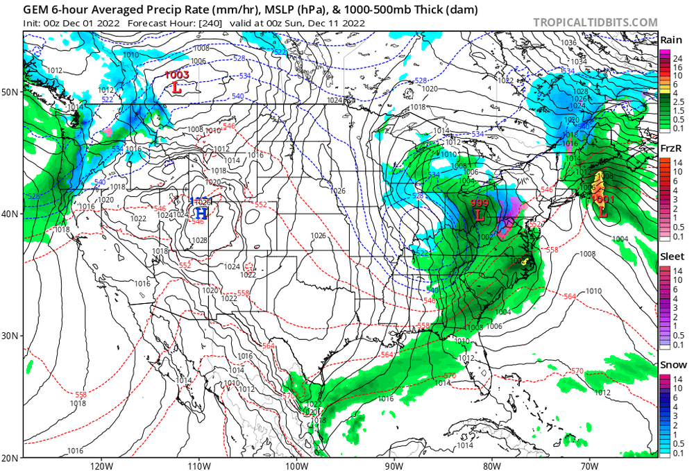
I’m all in with the Canadians evolution. It has a fairly weak low hit us the 9th, then the low slides offshore and looks like it’s going to continue sliding east. In most patterns, it would. However, the blocking doesn’t let the low move east. It has no choice but to come back and hit us again, and it deepens rapidly due to the warm Atlantic Ocean waters. The airmass is not all that cold, so we will be fighting rain snow lines. That is very much a risk this early in the season, however if the low gets strong enough it can and will create its own cold air. It looks like that is what the Canadian is hinting at, the airmass is fairly mild but the low creates it’s own cold air. This dynamically cools the column, leading to the rain snow line crashing SE. We get over 2 straight days of precip, with some areas in SE mass getting 3+ inches of QPF! Obviously it isn’t all snow, but still it shows just how much potential this pattern has. People clown on the Canadian a lot but I think it has the right idea. Whatever storm that hits us is going to just sit there and rot over us, leading to crazy high QPF outputs. The whole GFS idea of linking up the SE ridge to the block is complete bullshit, it’s more likely that the Patriots win the Super Bowl this year than that actually happening.
-
DCA _ NYC _ BOS ___ ORD _ ATL _ IAH ____ DEN _ PHX _ SEA -1.9 -2.3 -2.5 -3.1 +.8 +1.3 -5 -3.8 -4.6 DCA _ NYC _ BOS ___ ORD _ DTW _ BUF ___ DEN _ SEA _ BTV 12.0 62.0 105.0 65.0 70.0 140.0 60.0 8.0 130.0
-
It starts as rain yes, but the Midwest low looks like it’s starting to transfer offshore and absorb the smaller retrograding low to make one massive low. Looking at the H5 I would think the low would strengthen enough to create its own cold air, leading to the rain snow line crashing south.
-
The low in the mid west is turning into a Miller B and looks like it’s somehow pulling the coastal low in to absorb it. I…. have no idea what I’m looking at here and what this would look like if you extrapolate it