

George001
-
Posts
6,996 -
Joined
-
Last visited
Content Type
Profiles
Blogs
Forums
American Weather
Media Demo
Store
Gallery
Everything posted by George001
-
 This is a Miller A now? Oof I’m with you on that, I hate Miller As. I hope the evolution changes and we get a Miller B instead.
 -
Preliminarily ... a medium impact partial Miller B, Friday
George001 replied to Typhoon Tip's topic in New England
Same here, 40 degrees with light rain for me. -
Torch Tiger really wants the low to cut to Wisconsin with no secondary whatsoever, flooding all of New England with 60 degree temps and heavy rain. He likes warmer weather.
-
Is it correct to say with the setup in place for this threat that even if the low hugs and say goes over the outer cape, it would still be snow from say the south shore NW? A lot of EPS members have huggers so I’m curious about how that would look for eastern areas.
-
The strength of the signal this far out reminds me of the epic late Jan blizzard last year. All 3 major model ensemble suites are honking for a Miller B Christmas eve, nothing is a guarantee but that’s a great sign and is quite unusual this far out.
-
Great trends today. It’s insane that we have a 990mb MEAN on the EPS this far out. I even saw one or two 940s!
-
All good my man, I don’t take it personally. Hell, once I was corrected I realize how dumb it was to say it could snow well east of the low and was laughing my ass off with the others at how dumb it was. Life is a lot more enjoyable when you can poke fun at yourself and not take everything personally. But yeah I get why you and some others get frustrated with my posts, so I’ll going to try to tone it down some and make better posts.
-
Euro time coming up, last nights evolution but 200 miles east would be nice.
-
That’s fair. For me if it actually happens that way I’ll be pissed because it rained, but I know it’s going to change drastically since it’s so far out so it makes it easier to appreciate the evolution of the run for me. I get wanting to see the low farther east though, the Euro has been inland for a few runs now so it would be nice to see that change over the next couple of days. I would think even over the cape would be good.
-
Ya know, I actually enjoyed watching that crazy ass 0z euro run come just as much as I enjoy seeing blizzards on the models this far out. Even if it rained over my area it was a really cool evolution with wacky shit you never really see, like 7 different lows, snow well east of the low, ect. As many others corrected me about earlier, it won’t actually happen that way. We will see 2 lows at most, the primary and secondary low (Miller b) with a rain snow line NW of the low, not east. Still though, it was really cool to see that evolution even though it won’t happen.
-
I’m trying to think of ways to debunk that but I can’t. Goddamn it man, you just debunked all those posts I made about it snowing east of the low with one sentence. Hell, that even explains why my March 1993 example doesn’t apply, the ocean temps are much warmer than they are in March. I’ll admit it, I was wrong to not be concerned about the track of the storm. To be fair, in my defense the Euro did show snow east of the 960mb low in Central PA even if it wasn’t for my area.
-
This is batshit insane considering how far out the storm is
-
I’ll concede that it’s rare, but it can happen. Not only is there a frigid air mass preceding we also have strong North Atlantic blocking in place to lock it in. We have a frigid airmass, strong North Atlantic blocking, and a bombing low in the 960s. The Euro has it snowing well east of the low, and I read somewhere that the superstorm in March 1993 running inland. Yet Boston still got around a foot in that storm, despite being east of the low track. In my opinion if the EPS is right about the setup (big if to be fair), it will snow east of the low.
-
It cuts into Buffalo, but the airmass is so cold and the low is so strong it actually snows EAST of the low. That really is wild, and with a storm this powerful it’s very possible.
-
I love this look, most of those lows are in the 970s and 960s, with even one in the 940s! I don’t even care that most of them are huggers or run inland a bit, when the airmass is that cold and the low is that strong, I don’t see why it cant snow east of the low.
-
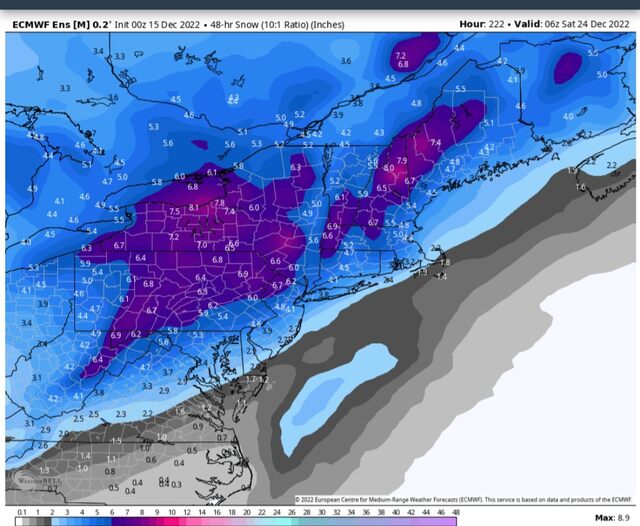
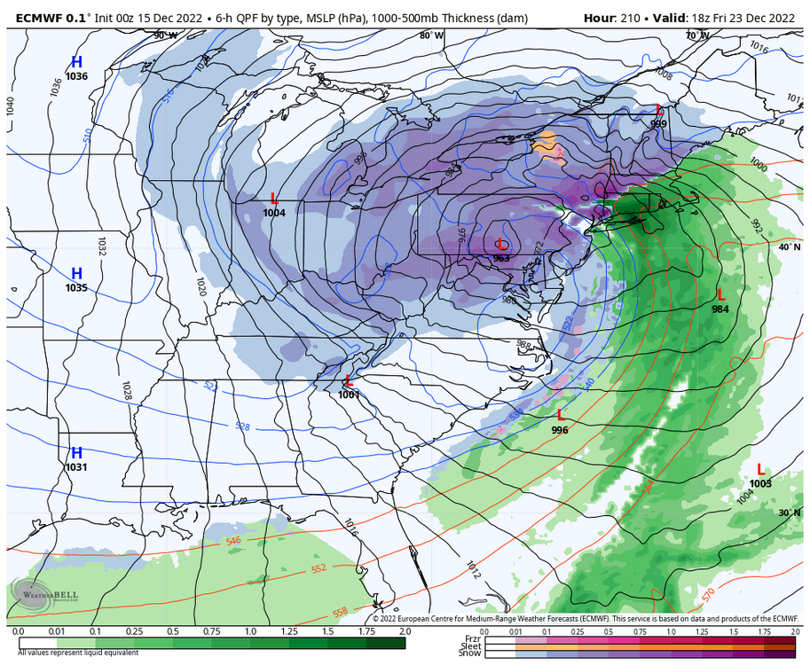
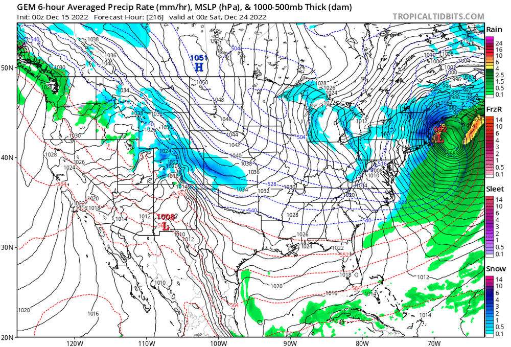
7 lows on the Euro, with a 963mb low in eastern central PA. I know it shows rain verbatim, but im not buying that with the airmass in place. It’s funny how it gives Philly 2 feet despite the low being well west, that’s how cold the airmass is. It shows how much room for error we have, if the low even goes into Western Mass instead of cutting to Buffalo, it’s very possible it would be heavy snow for all of SNE, even the coast despite the low running inland.
-
The Canadian has a 962mb miller B nor’easter just off the cape. Frigid airmass as well.
-
Yep I want a historic blizzard with feet of snow
-
Preliminarily ... a medium impact partial Miller B, Friday
George001 replied to Typhoon Tip's topic in New England
That’s very close -
A hugger might be fine with all the cold air in place
-
Preliminarily ... a medium impact partial Miller B, Friday
George001 replied to Typhoon Tip's topic in New England
I closed the shades for my area, but I opened them up again. It sucks that tropical tidbits doesn’t have the 925 mb layer, that’s the warm layer that is expected to screw eastern areas right? The evolution of the 850mb layer temps on the 3k nam hints at a low generating it’s own cold air via dynamical cooling. Verbatim it’s not enough, so most areas east of say the Berkshires rain most of the storm. However, models often underestimate the dynamical cooling effect. If the low deepens to say 988 mb instead of 992mb and the 925 mb temps are 2-3 degrees cooler than expected, maybe areas expecting all rain in eastern mass could wake up to big snows like in March 2013. It’s a low probability, more likely it will just rain but this has big upside if things break right. -
Preliminarily ... a medium impact partial Miller B, Friday
George001 replied to Typhoon Tip's topic in New England
Honestly that’s not as bad as I thought. Probably not going to happen, but that’s high enough to keep an eye on. -
Preliminarily ... a medium impact partial Miller B, Friday
George001 replied to Typhoon Tip's topic in New England
I know it’s unlikely, but what are the odds that the dynamics become strong enough to flip eastern areas to heavy snow early enough that we see eastern extension with the 6+ line to a BOS-PVD line? -
Holy shit some of those are in the 960s and one is even in the 950s
-
That 976 just off the cape would be nice


