

George001
-
Posts
6,996 -
Joined
-
Last visited
Content Type
Profiles
Blogs
Forums
American Weather
Media Demo
Store
Gallery
Everything posted by George001
-
Gotta get the Navy on board first
-
This doesn’t say anything about how warm it will be, just that Jan will likely be above normal. There is a huge difference between say +2 and +8, we could easily still get a snowy January at +2-3, but +6 or more won’t work. Considering that the first week of Jan is expected to be a blowtorch the probability of the month finishing warmer than average being this high makes sense. It will be very difficult to wipe out a +15 first week.
-
Happy holidays, hopefully we get some better luck Jan-March. Jan will likely finish mild (+2 on the month at least) due to the blowtorch start, but those same blowtorch SSTs that are screwing us now might help us later on in the winter. In 2015 eastern mass got buried by 4 monster blizzards from late Jan to mid Feb, then the mid Atlantic got their turn mid Feb to mid March when the dominant storm track shifted south. Eastern mass was the bullseye that winter but even the Mid Atlantic areas got a decent winter. This isn’t 2019-2020 or 2011-2012 at all, interior areas like the Berkshires, Buffalo, northern Vermont ect are getting absolutely buried. The cold is there, we had some blocking and today’s storm was a goddamn beast, just ran inland so we warmed up and rained. Although my December and (likely) week or 2 of Jan will end up being a massive bust, even if the first half of Jan is an absolute blowtorch (the first week probably will be, 2nd week could go either way) we still got the 2nd half of Jan, all of Feb, and 3 weeks of March (climo rapidly deteriorates after). You know what this reminds me of so far? 2012-2013. Dominant storm track was inland early in the winter, mild SSTS, but there were some warning signs that things would change later on (early blocking historically reloads and repeats later in the winter). January was an absolute blowtorch that year, but then the blocking reloaded and we got absolutely buried Feb and Mar. Feb 8th 2013 was the most extreme blizzard I’ve ever seen, and my area wasn’t even the jackpot! A bit over 2 feet of heavy wet snow, that’s insane. Normally to get those totals you need extremely high ratios and frigid temps, but this one was cold enough and absolutely loaded with QPF. That snowpack went nowhere, and then we got another severe blizzard in March that was forecast to be 2-4 inches before turning to rain, but never did! We got 2 feet of snow in what was the last big storm of the season, turning a slow staring mild winter into an epic one. I am convinced that all that moisture in what has been a wet winter will result in at least 1 severe blizzard in SNE later on when the blocking does reload and climo becomes more favorable. Peak blizzard climo in eastern mass is the first 2 weeks of Feb, with the 2nd half of Jan and 1st half or Mar being really good as well.
-
Yeah it seems to be all or nothing now. It’s too bad because with some better luck we might have gotten a few SWFEs and clippers in this pattern. I love blizzards, but it would be nice to get more smaller events in between when the pattern isn’t favorable for a big one.
-
Too early. 2014-2015 was mild in December and the first half of January. Lets see what the rest of December and early Jan does first.
-
I thought we had a great chance at a big storm but my snow goggles blinded me again
-
things have changed, the Euro went in the wrong direction. Im gonna bust again damn it! On to the next one
-
You think it stays weak? I’d love to see a weak west based nino next year.
-
Still 5 days out, too early to write it off. If the ridge doesn’t roll over this still has big potential, that has not changed.
-
Unfortunately that’s exactly how it went down. I love skiing but I am not very good at it haha
-
I’ve been skiing in Northern Vermont and it’s been great, I originally thought the pattern just sucked but seeing just how much snow they have up in NNE that changed my perspective. The pattern wasn’t a shutout garbage pattern, we really did just get unlucky with the dominant storm track being inland rather than slightly offshore. Last winter I’d argue was the opposite, the pattern sucked and we actually got lucky with that blizzard in late Jan. Last winter was below average everywhere in the northeast except for eastern Mass, which was above average to well above on the south shore (jackpot zone for the blizzard). It sucks that the storm track locked in west like that, but I have hope that it will shift SE and we get our chance. That cutter and the one week torch might be just what we need to reset the pattern and hopefully we get some luck on our side with the next pattern.
-
You aren’t entirely wrong in that phase 7 in moderate-strong Nina’s is mild, but it’s not a torch. Phases 4-6 are the torch phases, it looks like the MJO goes through those phases for a week. It’s a one week torch, that’s it. Idk what all the talk about closing the shades for 3 weeks is about, just like how the epic pattern was overhyped, the torch is being overhyped as well. I will admit, I am guilty of overhyping the epic pattern, I was thinking we would get 3-4 hits. If the models were wrong about that, why can’t they be wrong about having a 2+ week torch? The MJO only supports one week.
-
Doesnt quite get it done this run but damn that’s a big improvement. If the main system slows down enough that the 3rd piece in Montana phases we could see some crazy runs the next few days. Very excited to see the Euro tonight, good start to the 0z suite even if it’s not a hit yet.
-
Canadian looks improved with the ridge axis early on in the run
-
Yeah it still thinks the ridge rolls over
-
I don’t buy that the ridge rolls over from that depiction.
-
Positive PNA, weakening negative NAO, northern energy diving down and the TPV in eastern Canada. Yeah it would be nice to see that blue near Alaska a bit more west, but overall I thought this looked great.
-
Obviously it’s not a guarantee, but the blizzard talk isn’t “bullshit”. If the ridge doesn’t roll over, that would allow the intense northern energy phase with the southern energy. This setup has a strong high to to the north, the contrast between the high and low pressure if the storm phases would lead to intense winds as well as heavy snow. There absolutely is blizzard potential if things come together for this threat.
-
Nothing has changed, I still believe in this threat. I am convinced the amplified pattern will not allow the ridge to roll over. If anything, my confidence in this threat has increased over the past couple of days. The h5 looks great.
-
March 13th 2018 was ots even like 5 days out, then it trended hundreds of miles west last min. My forecast was for 2-4 a couple days out, then it got bumped up to 4-8, then 6-12, then 12-18, then I ended up with 2 feet of snow. It’s way too early to give up on this threat.
-
I’m not buying the gfs at all because it has the ridge rolling over. I could be wrong but I’m sticking to my guns, I’m convinced we see a drastic shift west on all guidance in 2-3 days. I’m all in on this threat, and plan to make a snow forecast tomorrow for this Miller B nor’easter/blizzard threat.
-
Jan 2015 had multiple 50+ days and I’m pretty sure it had a couple 60s the first half of the month. In Feb 2017 we had a blizzard days after 70 degree weather. Calling for +8 for an entire month based on a projected mild first week (still far enough out to possibly change) is ridiculous. The pattern early Jan on the models is obviously not a cold one, but it’s not record warm either. It looks like the -NAO reloads while the pacific is bad (+EPO) early month. It’s not a great pattern but closing the shades? Nah, positive NAO and EPO with a negative PNA is close the shades.
-
I noticed the western ridge was rolling over late causing the phase to miss. Since the models often rush pattern changes, I would think it’s possible the ridge never does roll over until after the storm. Isn’t that something that happens in a progressive pattern/fast flow regime? I don’t really buy that the pattern is progressive at all with Fridays low deepening to the 960s buckling the flow even more.
-
That’s a valid point you bring up, I’d take the 984mb due to the contrast between the low and high pressures. That’s a blizzard for sure.
-
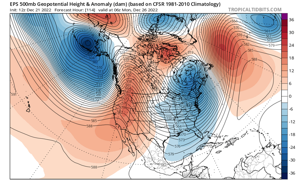
Shades remain wide open, yes it gets a little mild if the models are right but slightly above normal temps could still be snow in January in New England. The Mid Atlantic is probably cooked if this is right, but New England isn’t. Besides there’s the Miller B nor’easter/blizzard threat the 27th-29th. yeah I said it, and I stand by it looking at the 500 mb pattern. This isn’t some moderate 6-12 inch storm threat (not that there is anything wrong with that, hell I was hoping we would get a couple earlier in the month). The Euro is hinting at the incredibly rare triple phaser setup. Now I wouldn’t expect us to actually get a triple phaser. Just a normal phase would still be one hell of a storm, a triple phaser would lead to this suddenly becoming one of the snowiest Decembers on record. However, despite the triple phase being extremely unlikely, the fact that the best guidance we have is even hinting at that shows how much potential this storm has.


