George001
-
Posts
6,996 -
Joined
-
Last visited
Content Type
Profiles
Blogs
Forums
American Weather
Media Demo
Store
Gallery
Everything posted by George001
-
Last storm trended 1000 miles west. This storm is exactly what I want to see at this lead time. Well offshore, with a 500 mb pattern that argues for a farther west track. Hell, the Euro hinted at triple phaser potential. Looking at the surface yeah it look like there isn’t a threat, but there is a lot of energy flying around. The ingredients are all there, good airmass, ideally placed PNA ridge and weakening NAO blocking. Honestly, I’m kind of glad the Friday storm is going to cut and blow up rather than just be like a 990mb low over Boston or something. Really the difference for coastal areas is 55 vs 45 degree rain, but the monster cutter sets up the next threat better than a 990mb low over Boston would.
-
2nd half of December, Jan, Feb, and March. We’re heading into the 3rd week of December and the last week of March is very unfavorable, so I guess it’s more like 3 months of winter. Still, the point remains. There is a lot of winter left, hell winter hasn’t even officially started yet (it starts tomorrow, December 21st). I know some people say on here March isn’t a winter month, but I strongly disagree with that. March is more favorable than December for massive blizzards.
-
I don’t get writing off early January. The models were wrong about the epic pattern, they could easily be wrong about the expected garbage pattern. Just shift that vortex in AK a few hundred miles west and things look a lot different. The Friday storm, yeah that’s gonna cut. But after that in my opinion we will have more chances. The models are showing signs of the blocking reloading, but the Pac is bad similar to the first half of December. Even if the models are right, the shutout look only lasts like a week at most on most guidance. Besides, isn’t there a lot more room for error with a bad pac in January than December? The pac still matters don’t get me wrong, but maybe we can work with a bad pac+good Atlantic when climo is more favorable.
-
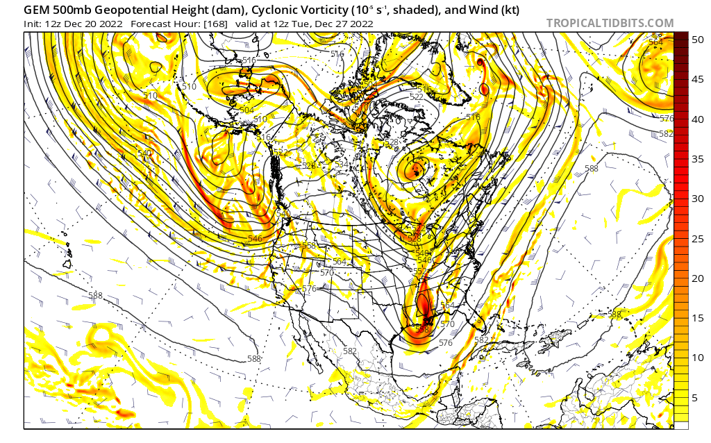
That is so close to a big solution, it barely misses the phase this run. The models have been trending west with the northern piece, if that phases in that low is not going out to sea. Not with the PNA ridge axis centered over Montana. The models often rush pattern changes, if the ridge breaks down just a bit slower than modeled right now we could have a slow moving Miller B on our hands.
-
I get the frustration, I’m frustrated too. It sucks that Fridays storm is going to cut, but it is what it is. We got a lot of posters having big melts, myself included. There’s nothing wrong with expressing frustration, but there’s still 3 and a half months of winter left! Is this threat a slam dunk? No, but it’s a legitimate threat with a high ceiling. We track, then yes, it looks like a mild stretch is coming. However, we can get big snows in bad patterns especially in January, so the shades remain open.
-
Canadian has the storm a couple days later
-
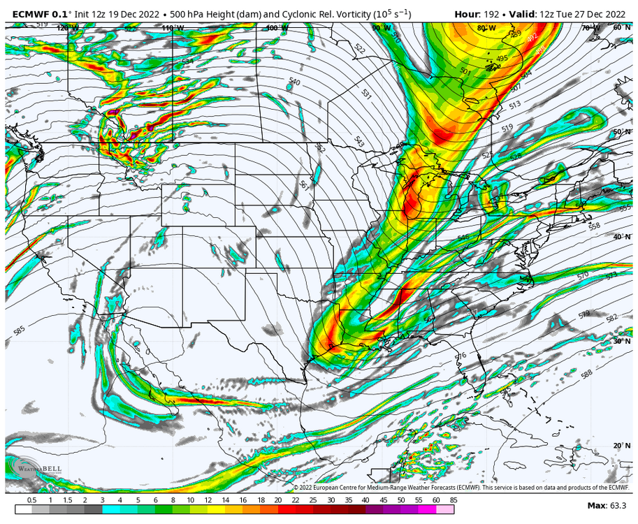
I know the models aren’t showing hits yet, but the 500s tell a different story. This look is REALLY close to something big for the shortwave diving down for the 27th threat after the big cutter. The western ridge axis is still quite far west, but it’s not offshore anymore. The NAO isn’t super negative but it is still negative which argues against a progressive solution (why I’m not buying the wave spacing issues, I’m thinking the northern energy will be much slower to enter the country). If that ridge pokes up a bit more and links up with the decaying block, I bet we will start seeing big solutions on the models. It’s really not far from doing so, it only needs a couple minor adjustments. This is a legitimate big dog Miller B nor’easter threat. That northern stream energy is quite powerful, and the teleconnections are in a transitory state.

-
 Snow east of the low? Nah no way
 -
Verbatim too progressive but it’s worth it watching this storm. This will likely change a lot until after the inland runner on Friday. The pieces need to come together, but if they do this storm has big potential, there is a lot of energy there.
-
It’s not looking great right now but just like how the models were wrong about the epic pattern, they could easily be wrong about the nasty +epo look. We track
-
Yep even my snow goggles aren’t strong enough to make this look good. A strong low in Michigan just isn’t what we want to see when looking for snow.
-
March 2018 was amazing. It can snow in December, but climo is really unfavorable for anything big. March is more prone to massive blizzards. People can say im exaggerating, but that’s what March 13th 2018 was. I got so much snow it caused a gigantic tree in my backyard to collapse under the weight of the snow. It was also extremely windy, that was no ordinary nor’easter, that was 12+ hours of blizzard conditions.
-
Shades are wide open. Nothing is showing right now but something could easily pop up and bury all of SNE. I don’t think the pattern is great but who knows maybe we can get lucky.
-
Ukie showing a foot+ well east of the low? Either it’s on to something unprecedented happening, or Uncle has been drinking again. That foot+ in south Jersey has me convinced Uncle is back on the hard liquor!
-
Yeah it should be we need a bigger boat not a bigger plow haha
-
Yeah just because we’re on the warm side of the storm doesn’t mean the storm isn’t impressive. It has the potential to develop into a historic blizzard, just not for us. It’s still going to be one hell of a storm for us with huge winds, coastal flooding, and heavy rain. That’s something that is worth tracking. It’s a weather board after all not just a snow board. We track rainstorms too on this forum, hell some of us even enjoy tracking rainstorms. Torch Tiger and Snowman19 for example probably threw a damn party when they saw the Euro cut the low into Michigan last night. They like warmer weather and massive rainstorms. They get a lot of shit for it, but all they are doing is celebrating the weather they enjoy. That’s no different than what snow weenies like myself do. I’m happy for them, we will get our blizzards later in the winter most likely, they will get their cutter for Christmas week. That’s why I love New England weather, there is something for everyone. If it just snowed all year long we wouldn’t have cool shit like bass fishing, golfing, etc.
-
The pattern did come (-nao, -epo, +pna), but the analogs didn’t work because the earth is warmer than it used to be. Yes I’m blaming climate change for this, I know I’ll get a lot of shit for it but this type of pattern used to be good until the damn ocean furnaced. Hell, the Atlantic is so warm I’m considering going to the cape and trolling for stripers right now in mid December. I bet I’d catch a massive bass. Oh well, on to January. After this cutter it looks like we will get a thaw for a bit on the long range models. I say bring it on, we need a pattern reset and reload.
-
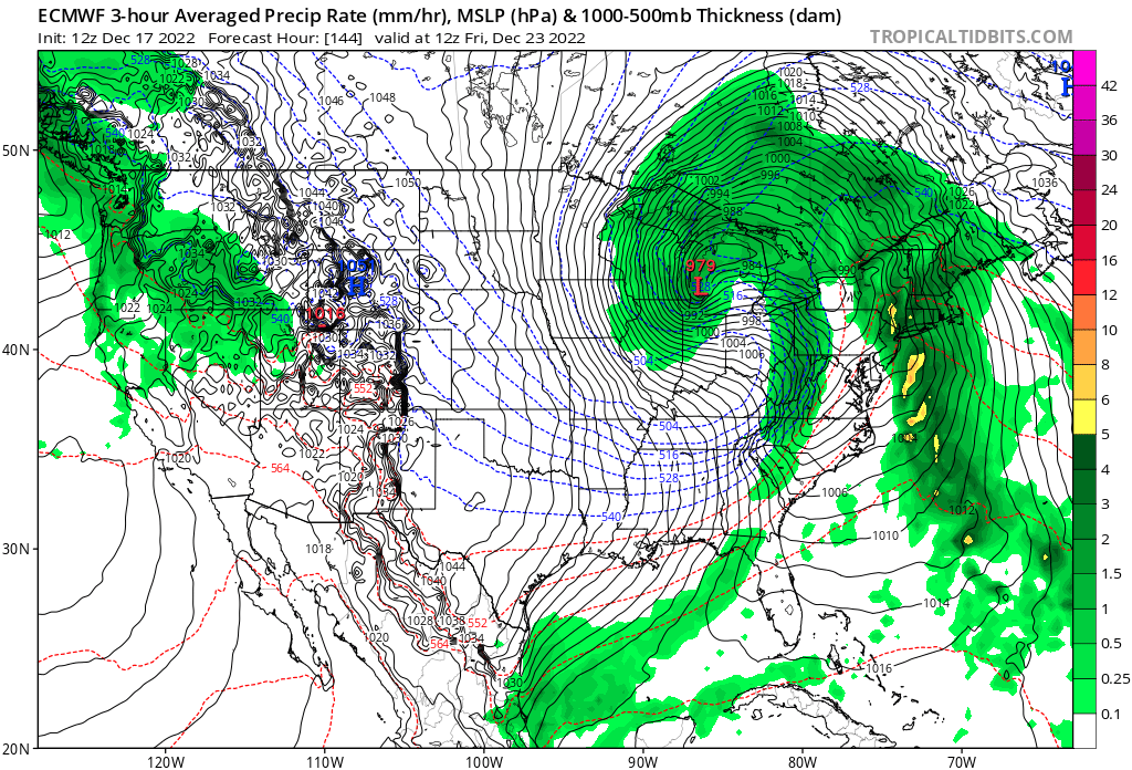
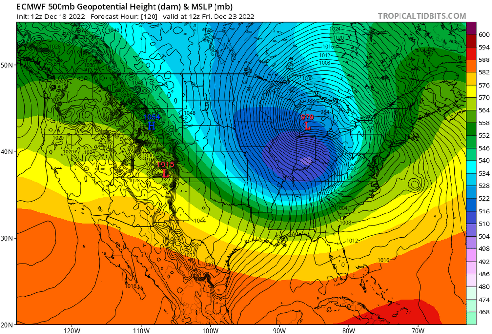
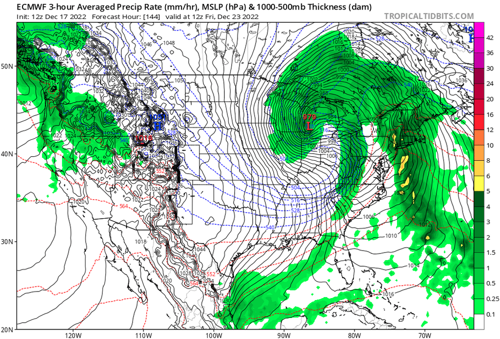
Euro has one hell of a storm, a 979mb low in Michigan. It looks like the models are starting to come to a consensus, the low isn’t quite going to get to Minnesota, but it’s not going to go over SNE like the gfs was saying either. It sucks that this won’t be snow for us, I jumped the gun for sure when I looked at negative NAO analogs in the past and assumed it would translate to multiple blizzards. Unfortunately, it doesn’t work that way. The temperature of the earth has increased, patterns that used to do one thing in the past may not do the same now. Is winter over? Hell no it isn’t, but this epic pattern that was hyped up didn’t really pan out. Oh well, I’m going to continue to track this storm. Yeah it’s going to rain, but still it’s one hell of a storm and will be exciting to track. Although most of us like snow here, there’s nothing wrong with getting excited about rainstorms too if they are a powerhouse like this one.
-
The low goes due north after that. 974mb low in Michigan, that’s not what we want to see. Hopefully it resets the pattern and we get a more favorable pattern for the following threats if it’s right. The western ridge axis is just too far west right now.
-
Yep, Euro has a low in Indianapolis.
-
Damn that’s a big shift
-
I know that would still be rain, but I’d be happy with that since it’s a step in the right direction. I hope my initial thoughts that it will go more west is wrong.
-
Euro time, anyone want to guess where it’s gonna go? I’m thinking we see a low in Nebraska tonight, but could see it in Wisconsin or Chicago as well.
-
There is a lot of uncertainty with the low location so far with the 0z runs. The Gfs has a low over SNE, Ukie with a low over Chicago, Icon with a low over Buffalo, and the Canadian with a low over Wisconsin.
-
I hope you are wrong but I agree with this. Honestly, I think the Euro is going to come west even more tonight. Low in Nebraska.