

Northof78
-
Posts
574 -
Joined
-
Last visited
Content Type
Profiles
Blogs
Forums
American Weather
Media Demo
Store
Gallery
Everything posted by Northof78
-

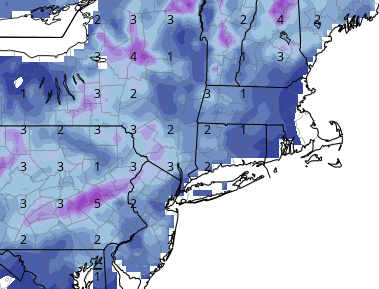
Two Mdt to high impact events NYC subforum; wknd Jan 6-7 Incl OBS, and mid week Jan 9-10 (incl OBS). Total water equiv by 00z/11 general 2", possibly 6" includes snow-ice mainly interior. RVR flood potential increases Jan 10 and beyond. Damaging wind.
Northof78 replied to wdrag's topic in New York City Metro
Everything still looks good and on track with an increasingly strong storm for 3-6"+ N of 78 and W of GSP, borderline 1-3"/2-4" near NYC, and then sloppy 1" or so W LI N NJ Coast...looks like a really nice storm for many (not all) in the forum.- 3,610 replies
-
- 1
-

-
- snow
- heavy rain
- (and 5 more)
-
Two Mdt to high impact events NYC subforum; wknd Jan 6-7 Incl OBS, and mid week Jan 9-10 (incl OBS). Total water equiv by 00z/11 general 2", possibly 6" includes snow-ice mainly interior. RVR flood potential increases Jan 10 and beyond. Damaging wind.
Northof78 replied to wdrag's topic in New York City Metro
Looks like 50-100 mile model run flip flopping, but relatively safe to say NJ coast/most of LI 1" or less, NYC borderline but most likely 1-3/2-4" decent storm, once into N/C NJ and NW NJ 3-6/4-8"...- 3,610 replies
-
- 1
-
-
- snow
- heavy rain
- (and 5 more)
-
Two Mdt to high impact events NYC subforum; wknd Jan 6-7 Incl OBS, and mid week Jan 9-10 (incl OBS). Total water equiv by 00z/11 general 2", possibly 6" includes snow-ice mainly interior. RVR flood potential increases Jan 10 and beyond. Damaging wind.
Northof78 replied to wdrag's topic in New York City Metro
This is a decent airmass, highs in upper 30s and dry will do it every time without too much of an issue in early January -
Two Mdt to high impact events NYC subforum; wknd Jan 6-7 Incl OBS, and mid week Jan 9-10 (incl OBS). Total water equiv by 00z/11 general 2", possibly 6" includes snow-ice mainly interior. RVR flood potential increases Jan 10 and beyond. Damaging wind.
Northof78 replied to wdrag's topic in New York City Metro
Looks like W of GSP and N of 78, good to go for a SECS; right along 95, tight, but probably decent accums of 2-4", once east of the city/LI/beaches less than 1"- 3,610 replies
-
- 1
-
-
- snow
- heavy rain
- (and 5 more)
-
How much did you end up with?
-
About 1" here with light snow
-
GFS is about 1" - 1.25" QPF for most of forum
-
NAM is a nuke for entire region, 2" QPF or more with 850s below 0F all time NYC west, boundary obviously an issue for light stuff before coastal cranks
-
NAM cold and around an inch of QPF
-
GFS and NAM fairly close in general set up and track now, with a bombing cyclone to our east...If you live north of TTN I think you are good for at least decent snows....
-
EURO snow map looks good?
-
NAM looks pretty good for #1
-
1.3" in Millburn last night, bringing 'season' total to 4.3"
-
The prior storm split the 2” or so almost 50/50?
-
2.8" final for the storm, and 3.0" for the season, at least got to see heavy/breezy and sticking snow for about an hour this season...
-
Wow, EURO 3/4" line all the way down in Monmouth/Mercer
-
Meanwhile...Ill take a 1-3" .....Book it!
-
Starting Jan 5-8 the pattern looks to turn near average/slightly below average temperature wise and quite stormy...should be a pretty good snow pattern after the 1st week of January
-
12/15 - 12/16 Coastal/Winter Storm & Observations
Northof78 replied to Northof78's topic in New York City Metro
Looks like NAM is a blast of snow on front end (at least) for most on the forum...with cold air actually building SW during this period. frozen/freezing line from Sandy Hook due West after much precip already has fallen @ hour 84. Both graphics are from hour 84 on NAM (with 1st being precip that has already fallen)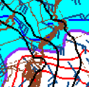
-
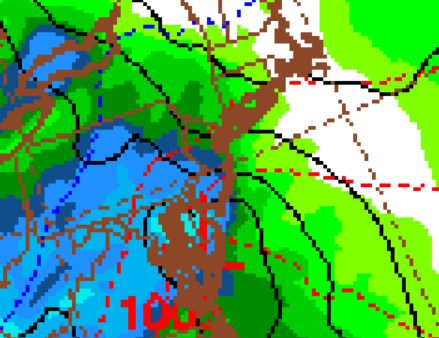
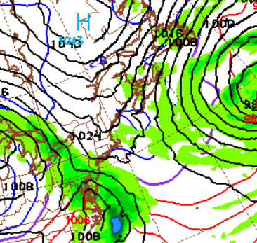
Increasing agreement for an impactful winter storm for some (or possibly most of the forum; especially NW) this Thursday and Friday. Strong Block and blocking low, entrenched arctic/cold air with low passing just to our SE or near our area. Should be a mixed bag storm for many with more accumulating snow likely. Below depictions from 12Z GFS. 12z CMC also shows a nice front end dump for many within forum.
-
New GFS would almost certainly start as snow for all/most and then transition to a mixed bag, timing of max retrograde of cold/arctic air and 50/50 vs. the incoming moisture will determine who on coast gets material snow, verbatim it has VA/MD/DE getting decent front end snow as well down to the coast, should be a decent winter storm for many on here with the block and embedded arctic air
-
Interesting trip into work this morning (Home: Millburn, NJ (just north of 78 and a couple miles W of the Parkway) Work: Oradell, NJ (NE Bergen Country, NJ) Light dusting on car tops @ home, up to light dusting in Short Hills, then 1/8" or so near Turtle Back Zoo, 1/2 - 3/4" or so near Montclair Golf Club, nearing 1" around Verona and close to 1.5" to 2" the rest of the way once to Little Falls to Oradell.
-
Has turned to light wet snow now...
-
Rain here, but per NWS obs snow line roughly 7-9 miles NW
-
Light mostly rain, but some mangled flakes
