BucksCO_PA
-
Posts
2,136 -
Joined
-
Last visited
Content Type
Profiles
Blogs
Forums
American Weather
Media Demo
Store
Gallery
Everything posted by BucksCO_PA
-
Thanks, apparently there was a strong case to be made that F5 damage occurred around the Assumption College area.
-
In 1953 Worcester was hit by an F5 tornado
-
93 (Jul/Aug), 94 (Jun/Jul) & 95 (Jul/Aug) were all brutal for 2/3's of the summer. July 15, 1995 is the benchmark for oppressive heat & humidity. Writeup from the NCDC storm events database: An oppressive heat wave gripped most of Eastern Pennsylvania. It climaxed on the 15th as almost every location reported record breaking heat. The dew point temperatures, reached into the 80s across southern Pennsylvania that day, an almost unheard of phenomena. This, combing with sweltering temperatures produced an apparent temperature of 129 degrees in Philadelphia. The heat wave was broken for most of state the night of the 15th as a backdoor cold front helped trigger a complex of severe thunderstorms. Relief for southeast Pennsylvania had to wait for a second cold front to move through the evening of the 18th. Forty people died because of the heat, about 80 percent of them within Philadelphia. Heat related deaths occurred in Philadelphia (33), Delaware (2), Lancaster (2), Chester (1), Clinton (1) and York (1) Counties. Most often the individuals who died were in poor health, shut-ins, lived in attached brick housing and had no fans or air conditioning. In the Susquehanna Valley two deaths were the result of outdoor activities, an 80-year-old man was sealing his driveway in Lock Haven and an 85-year-old woman was found in a Shrewsbury corn field. Hospitals treated greater than 100 persons for heat exhaustion. |Record breaking high temperatures on the 15th included 104F in Lancaster, 103F in Philadelphia (The highest in 29 years.) and Williamsport, 101F in Selinsgrove, 100F in Avoca, 99F in Harrisburg and 98F in Allentown. The excessive heat caused record demand to be reached by the Pennsylvania-New Jersey-Maryland Interconnection Association and Pennsylvania Power and Light on July 14th and Metropolitan Edison on the 15th. The excessive heat wreaked havoc as some roadways buckled. In Chester County, the Gay Street bridge was closed for 72 hours. Other roadway closures included Interstate 83 in York County, United States Route 422 in Montgomery County, United States Route 30, Pennsylvania State Routes 283 and 272 in Lancaster County and Pennsylvania State Route 248 in Northampton County. The excessive heat contributed to a prison riot in the Philadelphia Detention Center the night of the 14th and caused at least one water main break. Lastly, the heat wave took its toll on poultry and cattle. An estimated 1 million chickens died because of the heat in Pennsylvania, one-fifth of them in Lancaster County. Ninety-five percent of all chicken farms in Pennsylvania suffered losses.
-
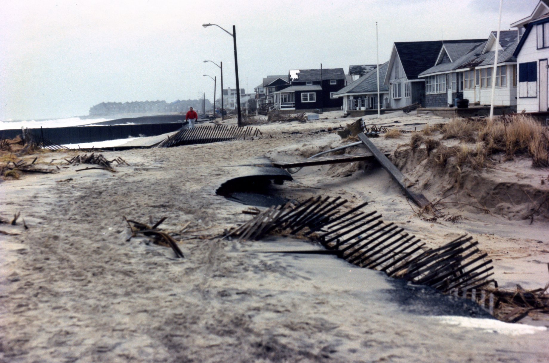
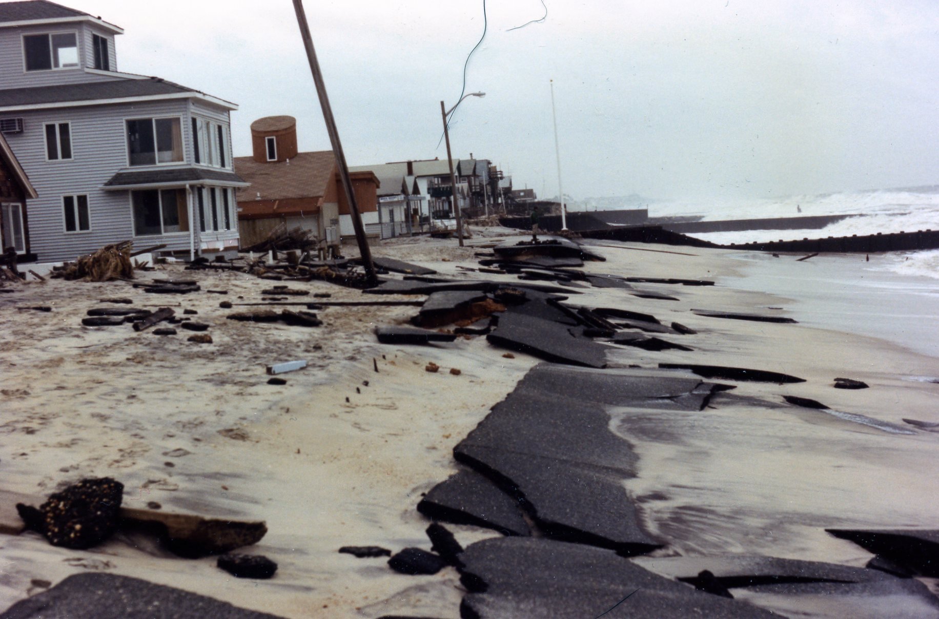
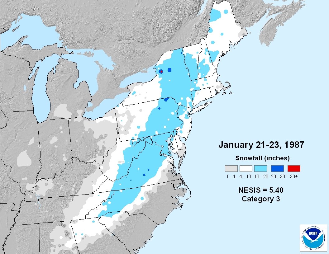
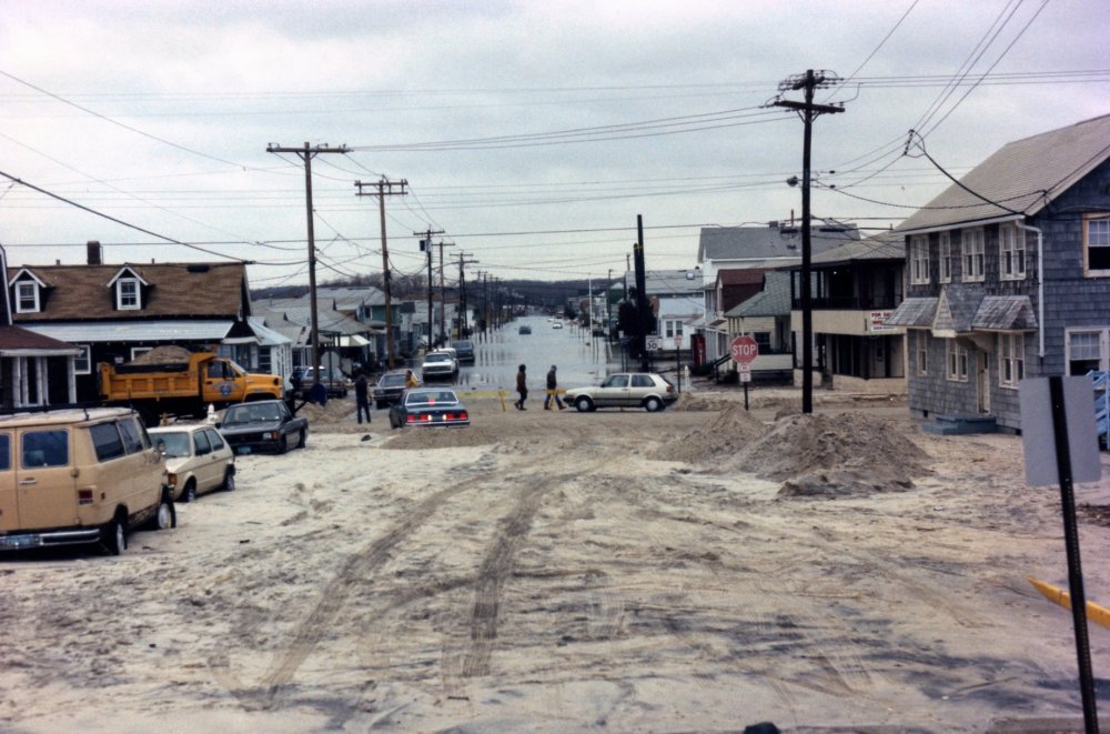
easterly flow was so strong with that storm it pushed the rain / snow line past State College pics below from Manasquan following that storm, worst winter nor'easter for the upper NJ coast whereas MAR 1962 is the benchmark for the SNJ coast


-
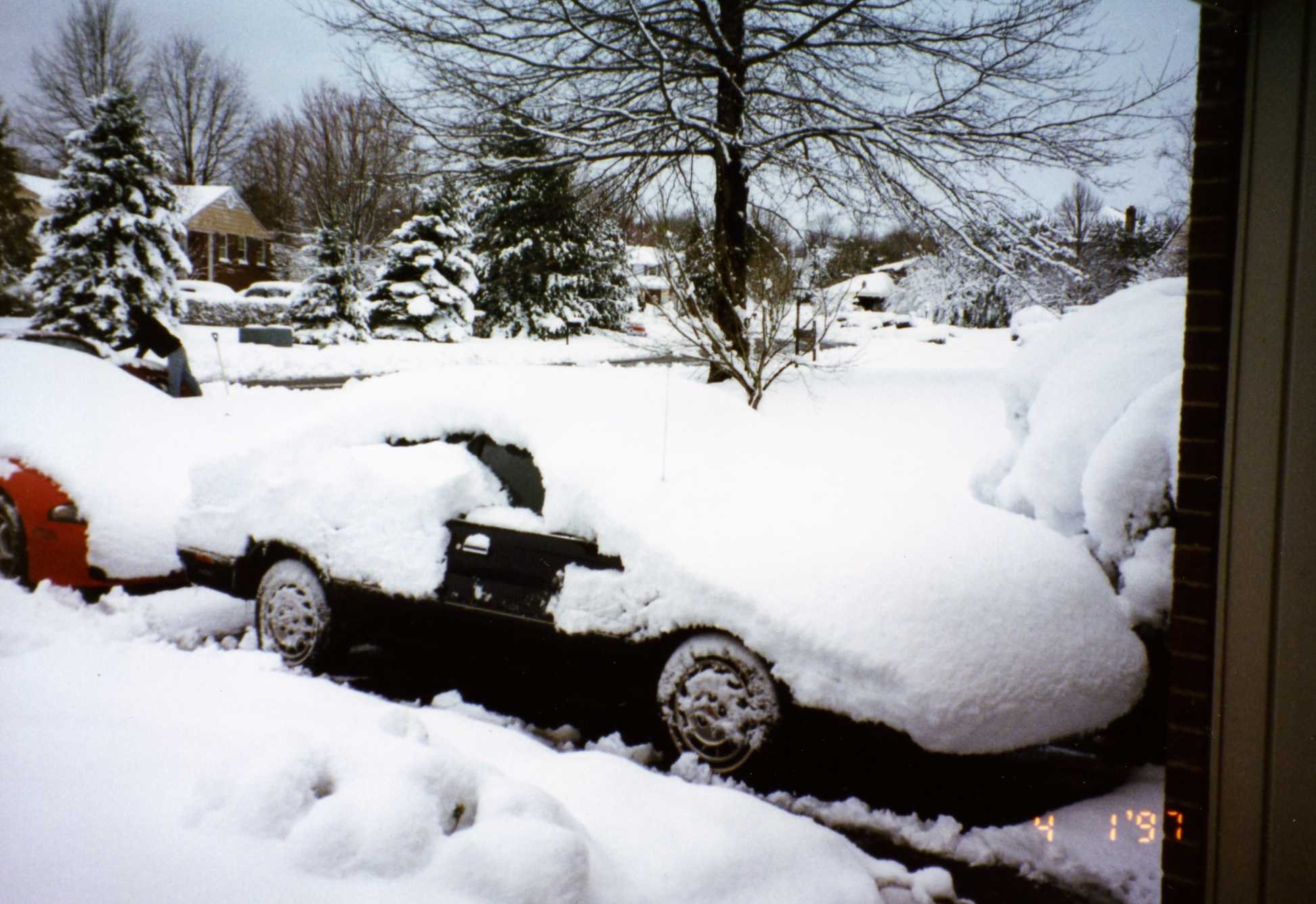
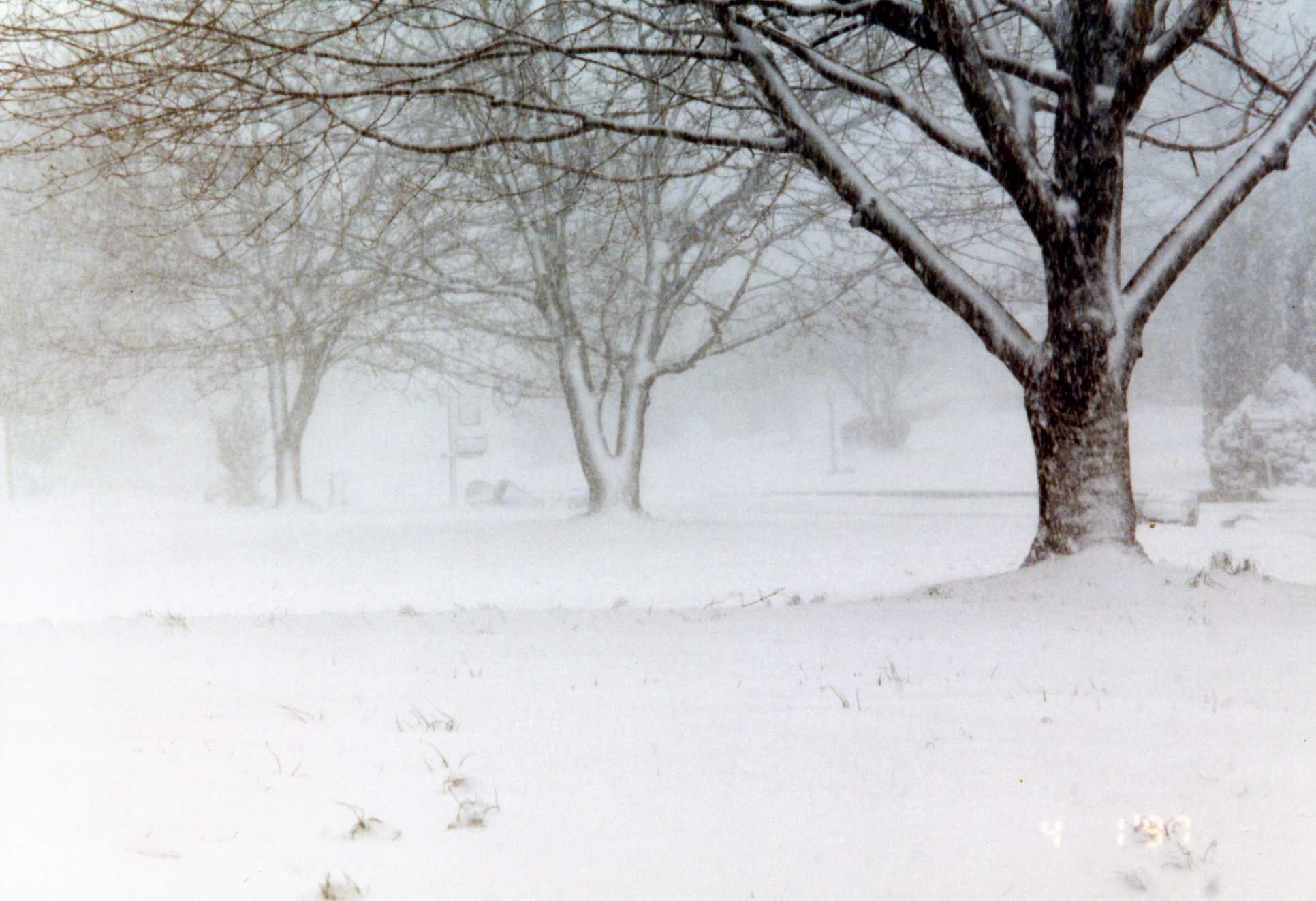
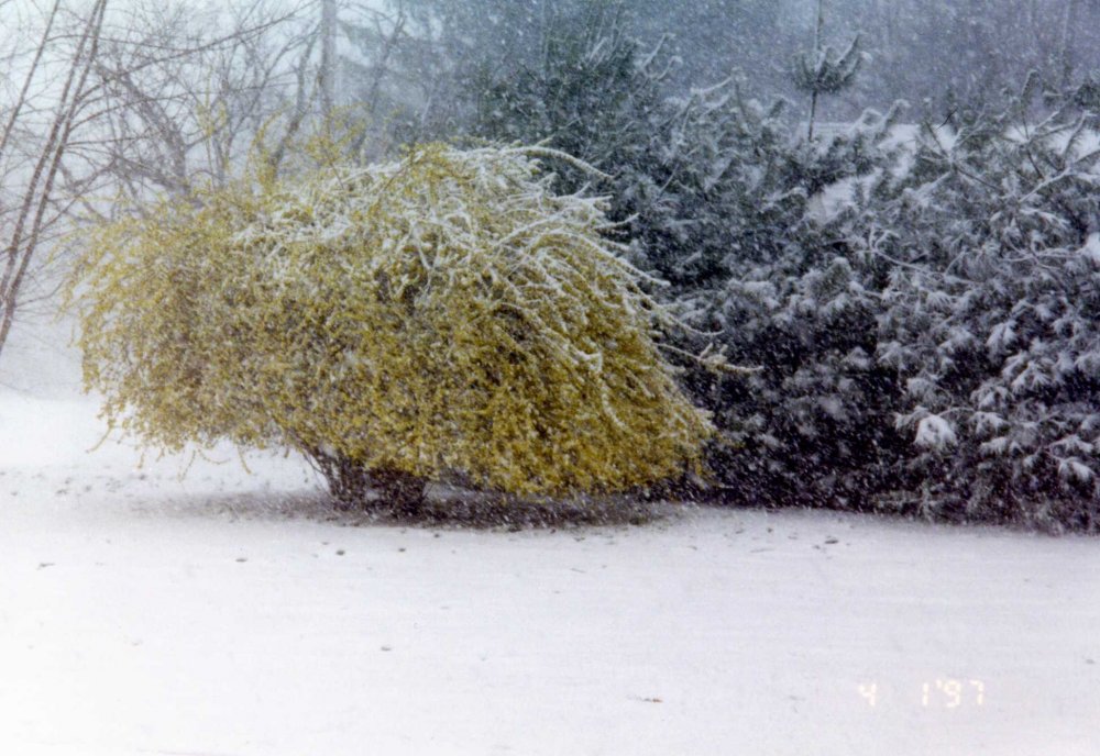
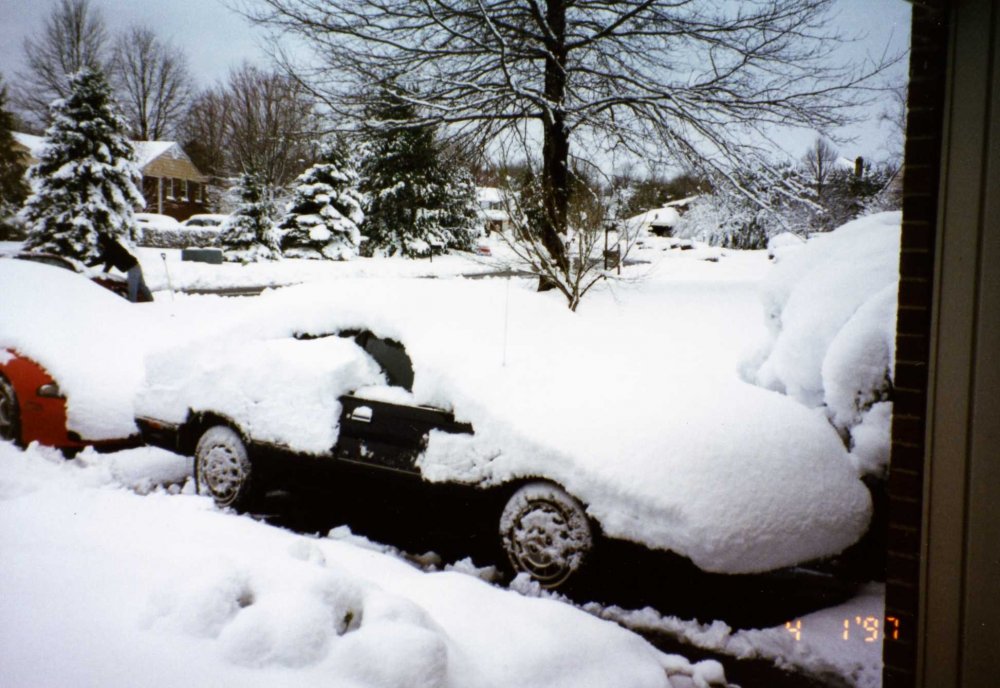
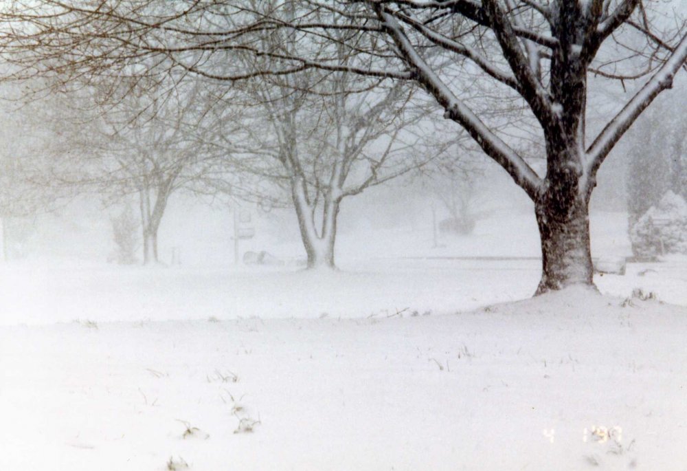
1997 SE PA: most of the snow actually fell on 3/31 with some lingering into the 4/1 early am, rain changed to snow the morning of 3/31 & fell heavily during the afternoon & early evening. Locally in Lower Bucks County very elevation dependent, less than 4" at 25' along the river in Levittown to 10" at my place 250' in Feasterville with upwards of 12" in neighboring Southampton. Backside / wrap around snows rarely produce locally, this one did. here's the narrative from the storm events database: https://www.ncdc.noaa.gov/stormevents/eventdetails.jsp?id=5599915 A late season snowstorm dropped some of the heaviest snow of all winter across Eastern Pennsylvania from the morning of March 31st into the morning of April 1st. The low pressure system responsible for this looked rather innocuous on March 30th as it moved with its associated cold front through the Midwest. Temperatures that day (Easter Sunday) warmed into the 50s and 60s across the area. But as the low intensified off the New Jersey Coast on the 31st, it pulled down colder air. The heavy precipitation it created also cooled the atmosphere and changed the rain over to snow. The rain changed to snow close to dawn across the Poconos. The changeover progressed southeast reaching the Lehigh Valley around 9 a.m. EST and Philadelphia close to noon EST. Bands of heavier snow moved through the Middle Atlantic States and caused wide variations in accumulations that were both location (underneath these bands) and elevation dependent. The Poconos and Western Chester County were hit the hardest. The combination of the heavy wet snow and strong gusty winds pulled down trees and power lines and caused blowing and drifting of the snow. It also caused major traffic accidents. The State of Pennsylvania declared a disaster emergency in Carbon, Chester and Monroe Counties. Interstates 80 and 380 were closed for up to 20 hours on March 31st and April 1st. The National Guard sent humvees into the area to rescue stranded motorists. In Monroe County, about 1,300 motorists spent the night of March 31st in shelters after traffic accidents and heavy snow forced the closure of Interstates 80 and 380. While the rain changed to snow early in the day, the problems started with the heavier snow during the afternoon. Over 250 accidents occurred. Near white-out conditions were reported between 8 p.m. EST on the 31st and 230 a.m. EST on the 1st. It was estimated nearly 3,000 vehicles were stuck on roadways. The heavy wet snow and strong winds also knocked down trees and power lines cutting off power to about 5,000 homes in the Poconos. Accumulations included 23 inches in Mount Pocono, 18 inches in Blakeslee, 17 inches in Long Pond and 9 inches in Lehighton. No serious injuries were reported. In Chester County, over 300 persons took shelter overnight in a firehouse under construction in the western part of the county. The heavy snow contributed to two traffic fatalities within the county. At 1230 p.m. EST an 18-year-old woman passenger was killed in East Nottingham when the vehicle she was in skidded and struck a pole. At 6 p.m. EST a 45-year-old male was killed in West Whiteland Township when his vehicle was struck by a delivery truck. In all, the county reported about 300 traffic accidents and nearly the same number of downed trees, wires, traffic lights and abandoned cars. Dozens of vehicles were abandoned between East Nottingham and Avondale. Fifteen tractor trailers were disabled on Pennsylvania State Route 41 alone. All or parts of Pennsylvania State Routes 10 and 41 and U.S. Routes 30 and 202 were closed in the county. The Philadelphia Electric Company (PECO) estimated 15,000 homes lost power in the county. Accumulations included 11 inches in Coatesville, 9 inches in Downingtown and 4 inches in Honey Brook. This storm featured bands of heavier snow. No place was this more apparent than in Berks County where accumulations ranged from a trace in western parts of the county to 10 inches in eastern parts of the county in Greenwich, Ruscombmanor and Union Townships. Interstate 78 was closed overnight between exits 12 (Greenwich Township) and 13 (New Smithville in Lehigh County) because of accidents and blowing snow. The eastbound lanes were backed up for 10 miles. The Pennsylvania Office of Emergency Management dispatched the Red Cross to help stranded motorists with food and drinks between exits 8 and 14 on Interstate 78. The Berks County Communication Center responded to over 50 serious accidents throughout the county between 3 and 9 p.m. EST. The most serious one (4 injuries) was a jackknifed tractor trailer that was rammed by a car and then a moving van on Interstate 78 in Windsor Township. GPU reported 2,500 homes lost power in the county, nearly all in Muhlenberg Township after a large tree came crashing down. In addition to Interstate 78, numerous accidents and road closures occurred on Pennsylvania State Routes 401, 422, 568 and 625. In the Lehigh Valley, northern parts of Northampton County were hit the hardest. The most problems were reported in Bushkill and Moore Townships. Accidents and/or downed trees shut down sections of Pennsylvania State Routes 33, 191, 248, 512 and 611. Forty motorists were stranded on Airport Road, their vehicles were unable to get up the hill just south of Pennsylvania State Route 329. At the Lehigh Valley International Airport, 4.4 inches of snow accumulated. Elsewhere around the Philadelphia Metropolitan Area, rush hour was called a nightmare in Bucks County. The southbound side of Interstate 95 was shut down for an hour because of a multi-vehicle accident. Pennsylvania State Route 412 was also closed because of accidents. In Montgomery County, numerous accidents were reported in Upper Pottsgrove, Worcester, Lower Pottsgrove and Lower Providence Townships. In addition, 11,000 PECO homes lost power. About 65,000 homes and businesses throughout the Greater Philadelphia Metropolitan Area lost power because of the combination of the heavy wet snow and strong winds. Within Philadelphia, there were over 200 trees that were damaged because of this combination. Accumulations included 12 inches in Furlong, 11 inches in Sellersville and Palm, 10 inches in Green Lane, 9 inches in Neshaminy Falls, 8 inches in Pottstown and Perkasie, 5 inches in Levittown, 3.9 inches at the Philadelphia International Airport and 3 inches at Valley Forge. While the snow was over by daybreak on April 1st, strong gusty winds persisted throughout the daylight hours hampering utility and road crew work. The strongest wind gusts averaged around 45 mph throughout the region. pics from Churchville, PA
-
PHL finished with 8.3" during the HECS & BWI had 4.0", so an 8.3" event is not that much LOL plenty of storms the last 10yrs that BWI or DC did better than PHL??? there's only 3 of any real significance MAR 2014, JAN 2016 & JAN 2019 PHL has not been doing that much better than Baltimore in general, OK if in general means the prior 2 seasons, otherwise the average over the past 10 seasons is not even close: PHL - 24.1" / BWI - 16.6" / DCA - 11.6" I didn't include this season since it's still open however at this point the disparity will only increase unless some big changes: PHL - 23.0" / BWI - 10.0" / DCA - 5.4
-
traditional climo as we know continues to be rendered irrelevant, the weak sauce history of -AO / -PNA combo snowstorms this time of year was really taken to the wood shed
- 1,932 replies
-
- 1
-

-
- heavy snow
- wind damage
- (and 1 more)
-
January 2021 General Discussions & Observations Thread
BucksCO_PA replied to Stormlover74's topic in New York City Metro
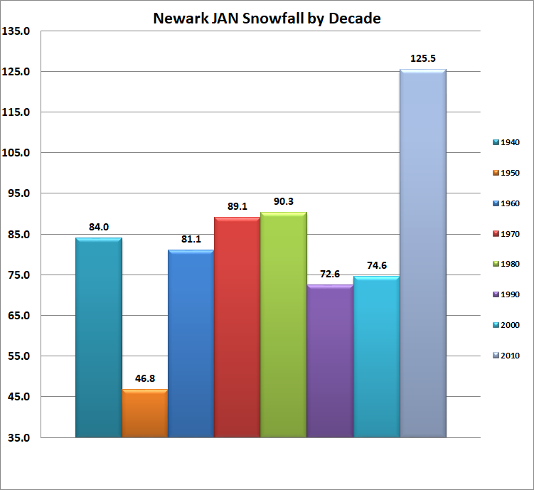
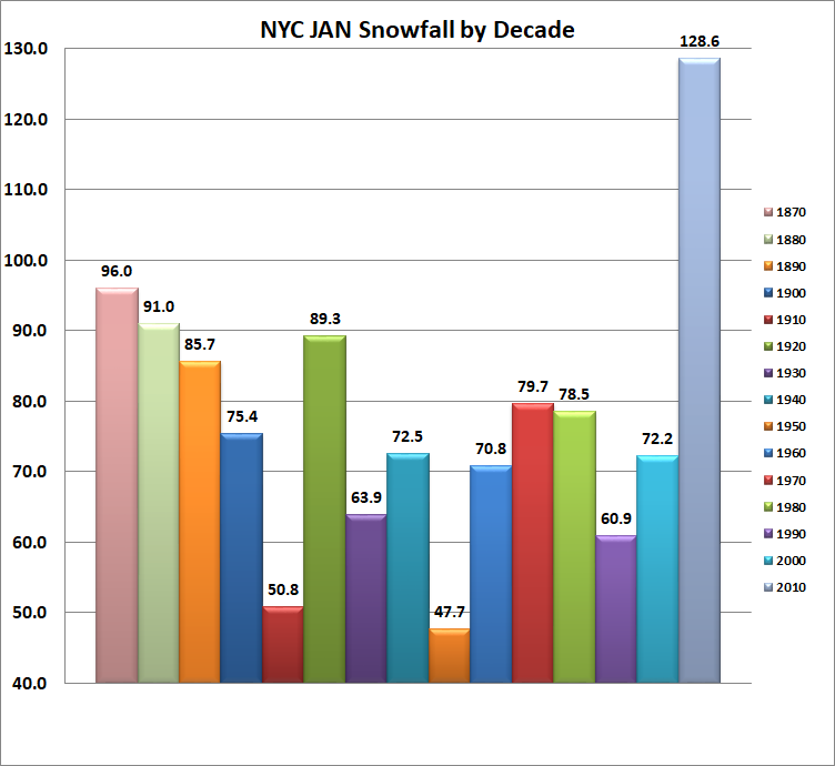
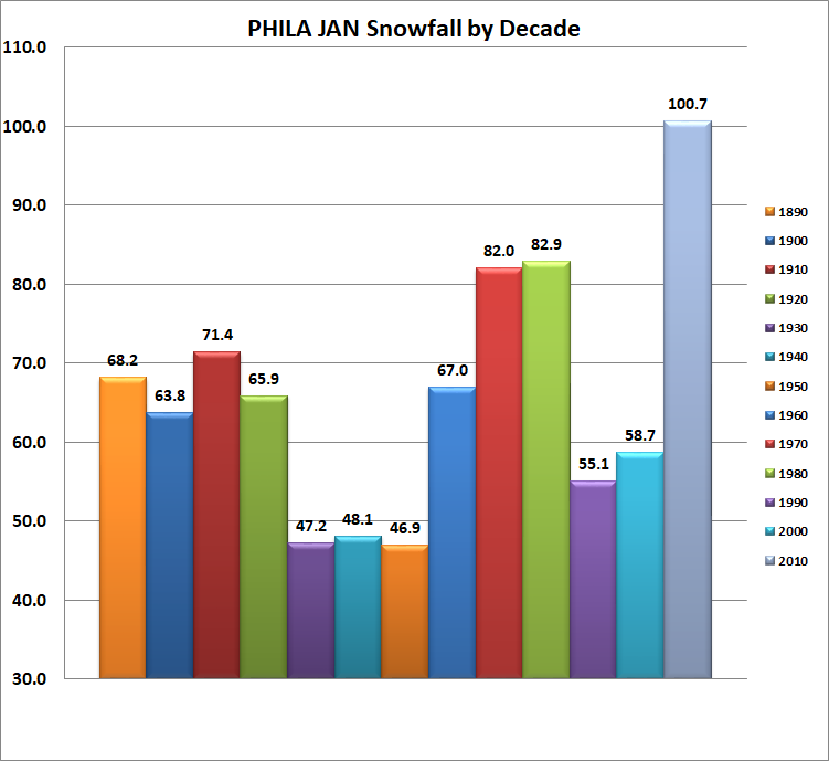
Very little snow during the 1980's Jan is a myth that's been tossed around here & back when there was a pulse in the Philly forum. The reality is the 80's Jan were very good overall at Newark, Allentown & Philadelphia. At all 3 locations that was the 2nd snowiest decade on record during the month of Jan, most impressive for Philly with the long period of record. As for NYC during the 1980's Jan was slightly snowier than the period of record mean & median however since the 1930's it's in the top 3 outproducing 6 other decades. The long term Jan average at NYC is 7.8", 6 out of the 10 Jan's during the 1980's were above average. From a decade standpoint during Jan the 1950's are far & away the benchmark for pathetic snowfall.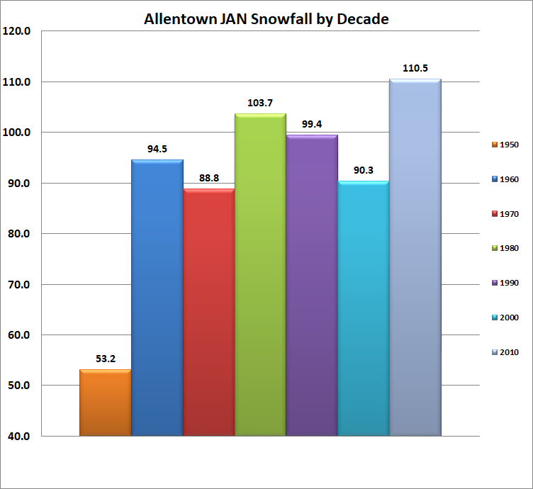

-
December 2020 General Discussions & Observations Thread
BucksCO_PA replied to bluewave's topic in New York City Metro
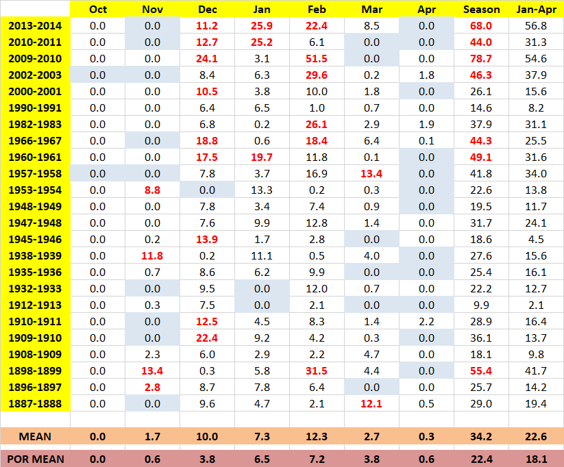
This past WED-THURS (6.6") was the 25th 6" or > snow event on record at Philadelphia prior to JAN. On 16 occasions following the prior 24 events another 6" or > snowfall event was observed later that season. Since the NOV 1953 event the more recent trend is 10 out of the past 11 which includes a run of multiple follow-up events since 2002. Philadelphia has never recorded more than one 6" or > snow event in the same season prior to JAN. Philadelphia snowfall records date back to 1884. Digger a little deeper here are the subsequent snowfall totals for the 24 seasons with the 6" or > snow event. Observed mean is 22.6" vs. the 18.1" long term period of record JAN-APR average.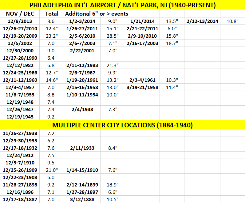
-
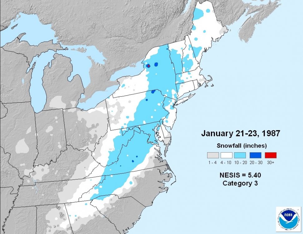
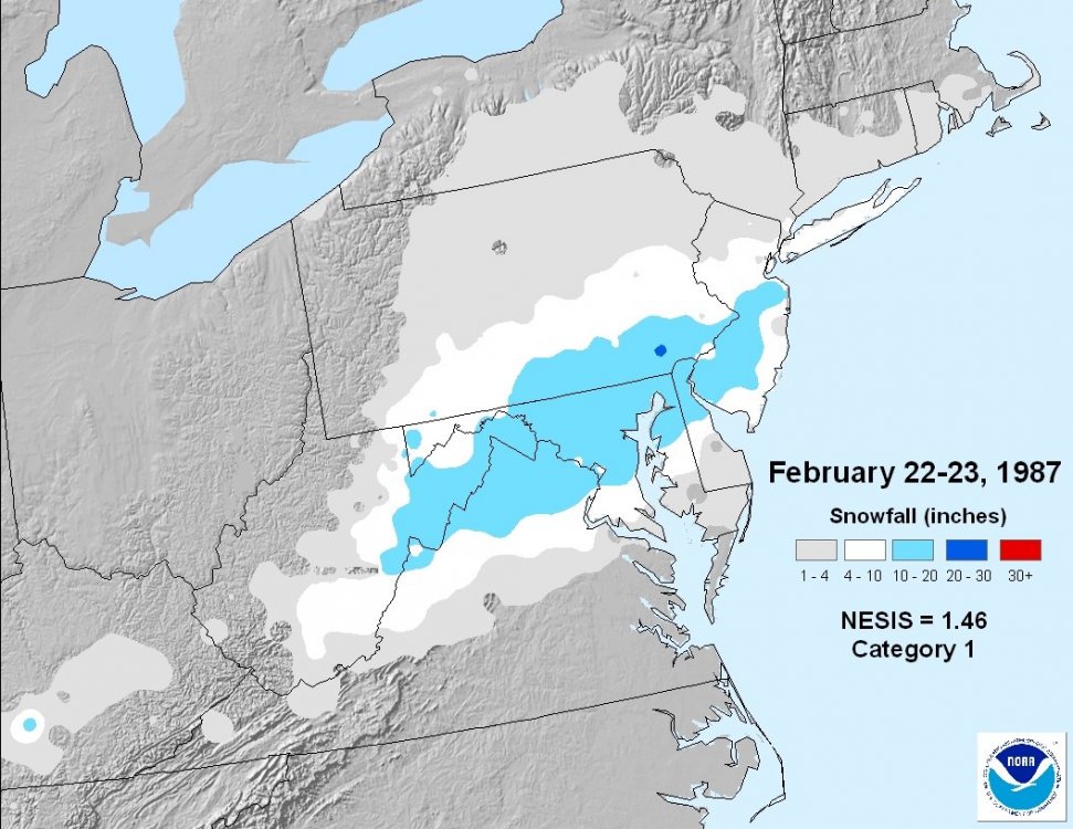
Jan 13-14, 1982 & Jan 22, 1987 were not suppressed, Feb 22-23, 1987 was huge just south of NYC looking at NYC during the 80's, yikes, I didn't realize it was that bad, only 69% of the long term average over the decade Philadelphia was better at 91% & Allentown, PA even more so at 94%. At Allentown 5 of the 10 seasons during the 80's were above average snowfall wise. Here in the northern Philly burbs during the 1980's snowfall was often significantly higher than the reports coming out of the airport. Most noteworthy was FEB 22-23, 1987, we had 18"-19" while PHL checked in with less than 7". Locally JAN was an excellent month during the 1980's however FEB & particularly DEC were lame. From a decadal standpoint JAN during the 1980's is the 2nd snowiest JAN on record behind 2010's. Combine the snow with the brutal cold during that decade & what snow fell stuck around. At Philadelphia there were 100 JAN days during the 1980's with at least an inch of snow cover whereas the 2010's with 18% more snow recorded 64 such days.
-
Atlanta had 3 days of 0 or below weather that month, most of any month on record. 2-3 days later a huge snowstorm affected most of the eastern U.S., 6"(+) from Atlanta all the way to Portland. That storm is infamous for the DC Air Florida crash into the 14 St bridge then ultimately falling into the frozen Potomac River. The late 1970's thru the mid 1980's had significant arctic outbreaks nearly every season.
-
December 2020 General Discussions & Observations Thread
BucksCO_PA replied to bluewave's topic in New York City Metro
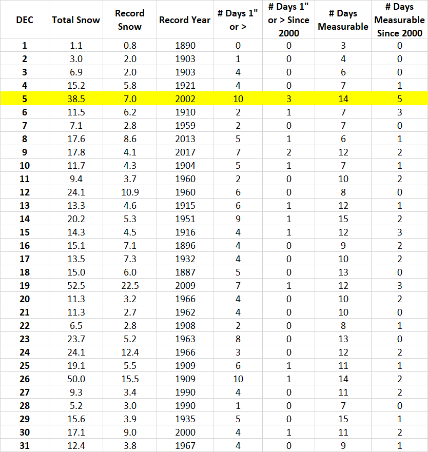
Earlier on another forum I put together the DEC daily snowfall climo for Philly. The focus was the unique 12/5 snowfall legacy but you can see using a recent trend back to 2000 the frequency of days with 1" or > snow is significantly higher during the beginning third of DEC as opposed to the middle & later part of the month. Like NYC there hasn't been a late DEC day with an 1" of snow since Boxing Day 2010. There's always DEC 5th for your early season hopes: In terms of total snowfall 12/5 is the 3rd snowiest of any DEC day 12/5 is tied with 12/26 for the most # of 1"or > events during any DEC day It is also tied with 12/26 for the 2nd most measurable snow events during DEC Regarding recent trends over the past 20 yrs. 12/5 has recorded more 1" & total measurable snow events than any DEC day Philadelphia snowfall records date back to 1884 Expanding on recent trends there have been significantly more 1" snowfall events during the beginning of DEC since 2000. 8 - 12/1-12/10 4 - 12/11-12/20 3 - 12/21-12/31
-
November 2020 General Discussions & Observations Thread
BucksCO_PA replied to Rtd208's topic in New York City Metro
yesterday's final split - 37 /24 nearby TTN also 37 degrees for a high yesterday, that is tied for the 4th coldest max on the date, coldest since 1959 22 degrees this morning -
November 2020 General Discussions & Observations Thread
BucksCO_PA replied to Rtd208's topic in New York City Metro
Don't get me wrong that winter wasn't epic & something that'll be remembered for years however it does have it's moments. At Philly the 31 day period from 1/14 thru 2/13 was quite cold, -6.4 degree departure. Over that span 15.8" of snow officially at the airport, a tick or two more here locally NE of the city. What's interesting is the # of consecutive days with at least 1" of snow cover. At PHL snow depth records go back to 1948 and that winter had the 3rd longest stretch on record. JAN/FEB 1961 - 28 days FEB/MAR 2003 - 26 days JAN/FEB 2000 - 23 days Locally I finished that season with just over 24" close to average. Included an APR stat padder, throw in some bonus pts. for a double digit storm & yeah after the laundry list of dreadful outlooks I'd sign up for something similar. Locally 37 / 31 split so far today, 37 is the coldest high temp since FEB 29th 1st freeze if not late tonight then certainly tomorrow morning at PHL, the airport will finish with a growing season of 260 days while my location 10 miles NE of the city is a dramatically different 173 days thanks to the solid May freeze. -
November 2020 General Discussions & Observations Thread
BucksCO_PA replied to Rtd208's topic in New York City Metro
Temp averages & trends for the Philadelphia POR, recent trends since 2010 & during the past 30 yrs. relative to average no month has warmed more than DEC. The DEC mean since 2010 is over 40 degrees, nearly 3 degrees above the current normal. Looking at the bleak LR outlook & ISO's winter forecast I wonder if our best hope is for a JAN 2000 type scenario in which we see a solid 2-3 wk. stretch of winter & then on to a very early spring? .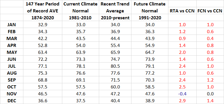
-
November 2020 General Discussions & Observations Thread
BucksCO_PA replied to Rtd208's topic in New York City Metro
DEC 2015 was just sick, looking at the Philly figures the past 6 days averaged 11.7 degrees above average while the 6 day super torch during late DEC 2015 averaged +25.8 degrees. PHL recorded 10 days which averaged 20(+) degrees above average that month. 65 degree DP's on Christmas Eve.......ridiculous stuff. -
Griteater's Winter Outlook (20-21)
BucksCO_PA replied to griteater's topic in Weather Forecasting and Discussion
Tough to tell since it's so far back & I can't find the hourly OBS but appears there could have been a decent early winter icing event that transitioned to snow. 12/4 - 32/26 split, 0.52" of precip, no snow recorded 12/5 - 29/22 split, 0.24" of precip, 2.8" of snow Hard to believe it could snow at Philly on DEC 5th, LOL -
November 2020 General Discussions & Observations Thread
BucksCO_PA replied to Rtd208's topic in New York City Metro
75 degrees is average high temp for Jacksonville, FL today. -
November 2020 General Discussions & Observations Thread
BucksCO_PA replied to Rtd208's topic in New York City Metro
1938 was a very interesting month, yesterday I was looking at the top 30 warmest NOV's at Philly for the most 70 degree days & that year is #2 with 8 such days. What's cool is the first 23 days of that month averaged 54.2 degrees which is 5.4 degrees above average & on pace for the warmest NOV on record however the last 7 days of the month averaged 30.4 degrees representing a -13.2 degree departure. Additionally over the last 7 days Philadelphia recorded 11.2" of snow making NOV 1938 the 2nd snowiest NOV on record. Looking at Newark the warmth wasn't as pronounced over the 1st 23 days, 51.8 degrees (+3.8), but like Philly the cold & snow at the end of the month was extreme. Temperature wise the final 7 days averaged 28.4 degrees (-14.5) & over that timeframe Newark recorded 14.2" of snow making NOV 1938 the snowiest NOV on record. -
Nate Silver should be flipping burgers next week. You'd figure when the Trump campaign was redirecting ad buys from FL to other states a week before the election that would've raised some red flags with the Biden +5 polling in that state. Toilet poll of the election goes to ABC / Wash compost, WI +17 Biden a week before the election. Seriously how is this slop even published or factored into RCP averages? Once again Trafalgar & Susquehanna blew away the competition
-
remnants of zeta and potential first flakes for some areas
BucksCO_PA replied to forkyfork's topic in New York City Metro
Their longitude may help them even more than their latitude. -
point & click for Logan has 25 degrees for a low, that would tie 1936 & 1879 for the all time OCT low all 4 measurable OCT snow events on record at Boston have occurred since 2005
-
remnants of zeta and potential first flakes for some areas
BucksCO_PA replied to forkyfork's topic in New York City Metro
most recent OCT freezes: Newark - 2015 PHL - 2011 JFK - 2011 Central Park - 1988 LGA - 1972 -
October 2020 General Discussions & Observations Thread
BucksCO_PA replied to uofmiami's topic in New York City Metro
Great Falls has a solid snowfall period of record, back to 1892. Trend certainly has been snowy since the turn of the century, 26 top 10 snowiest months since 2000 including 7 out of 11 being the snowiest months on record.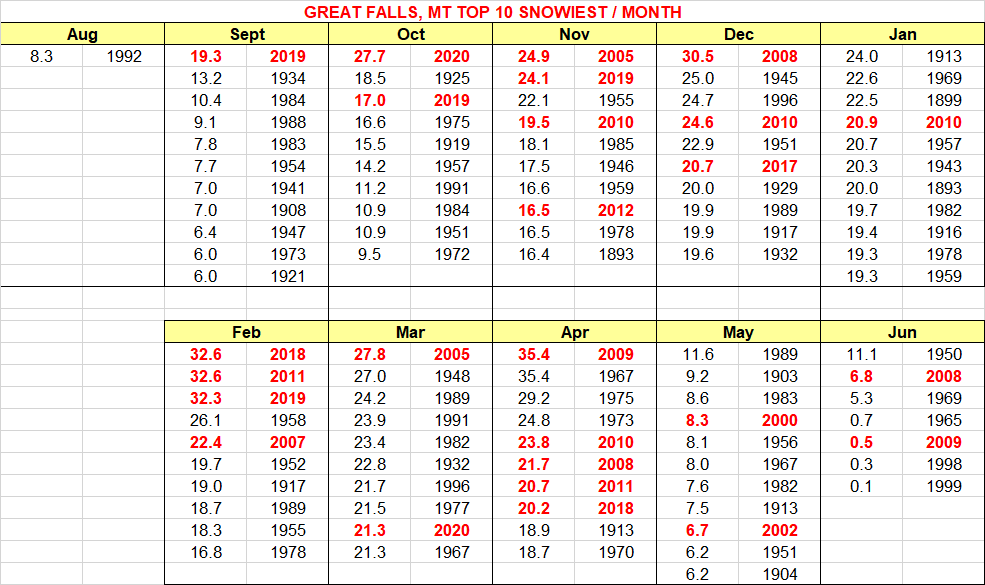
-
October 2020 General Discussions & Observations Thread
BucksCO_PA replied to uofmiami's topic in New York City Metro
as far as NOV snow, if that corresponds to remainder of the 1977-78, 1978-79, 1995-96 & 2013-2014 seasons than count me in Looking at the Philly snowfall period of record there have been 40 seasons in which measurable snow was recorded in OCT and/or NOV & the subsequent snowfall average for the rest of the season was 23.2". On the flip side the 95 seasons without any OCT / NOV measurable snow average 21.3"for the rest of the season. The long term POR average DEC-APR snowfall at Philadelphia is 21.8".