BucksCO_PA
-
Posts
2,136 -
Joined
-
Last visited
Content Type
Profiles
Blogs
Forums
American Weather
Media Demo
Store
Gallery
Everything posted by BucksCO_PA
-
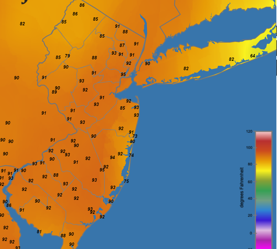
Sections of coastal Monmouth & Ocean benefitting from the SB while the S. Jersey beaches roast. SB did make some headway into AC but the NW wind beat that back & it's once again 92 degrees at the marina, up 10 degrees the past hour. https://www.njweather.org/maps/mapviewer?mapname=temperature

-
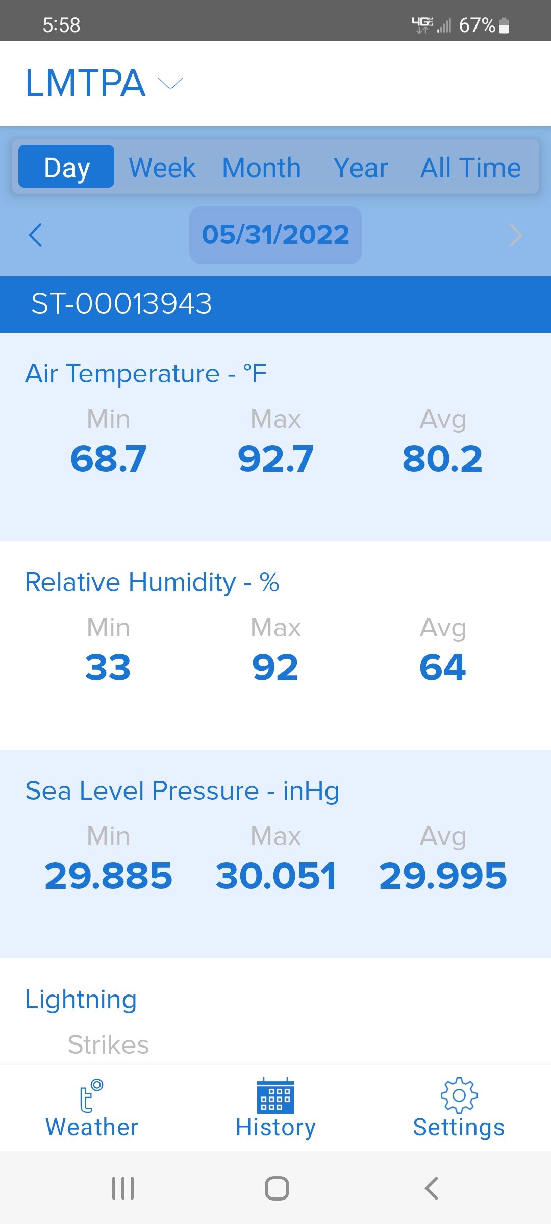
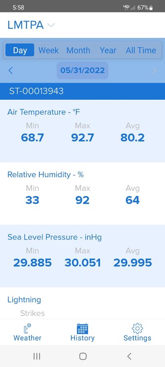
93 / 69 locally for the spread today. Highest heat index I saw was 94 degrees. High at nearby TTN was 92. 96 degrees at PHL was just one shy of all time Philadelphia May max.
-
3:00 92 / 62 H.I. - 92
-
90 / 65 @ 2:00 H.I. - 92 3rd 90 day of the year
-
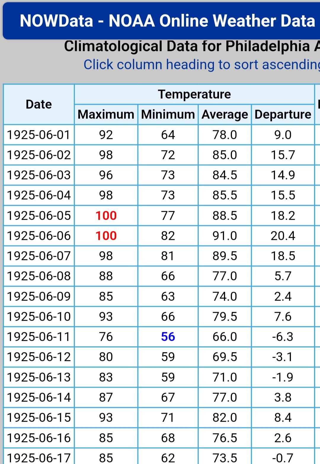
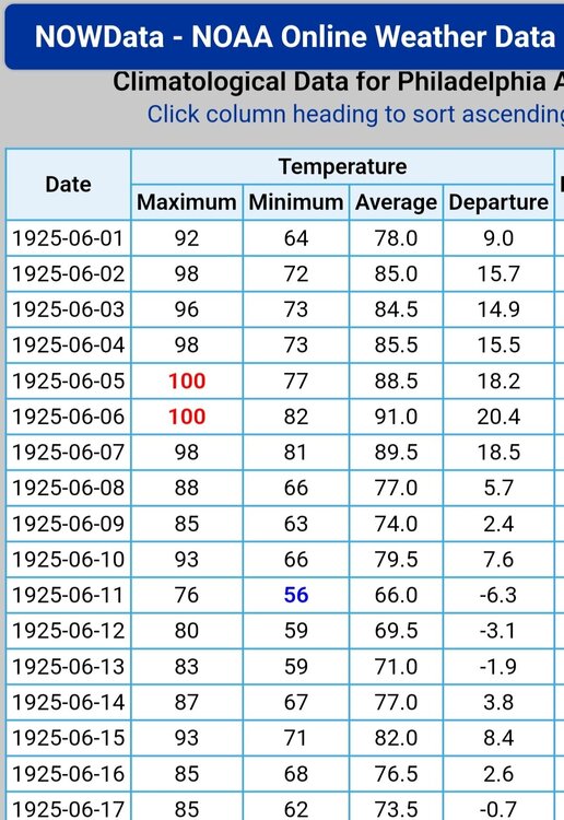
Yep, when it comes to early June heat there's 1925 and then there's everything else.
-
https://www.ncei.noaa.gov/access/coastal-water-temperature-guide/catl.html
-
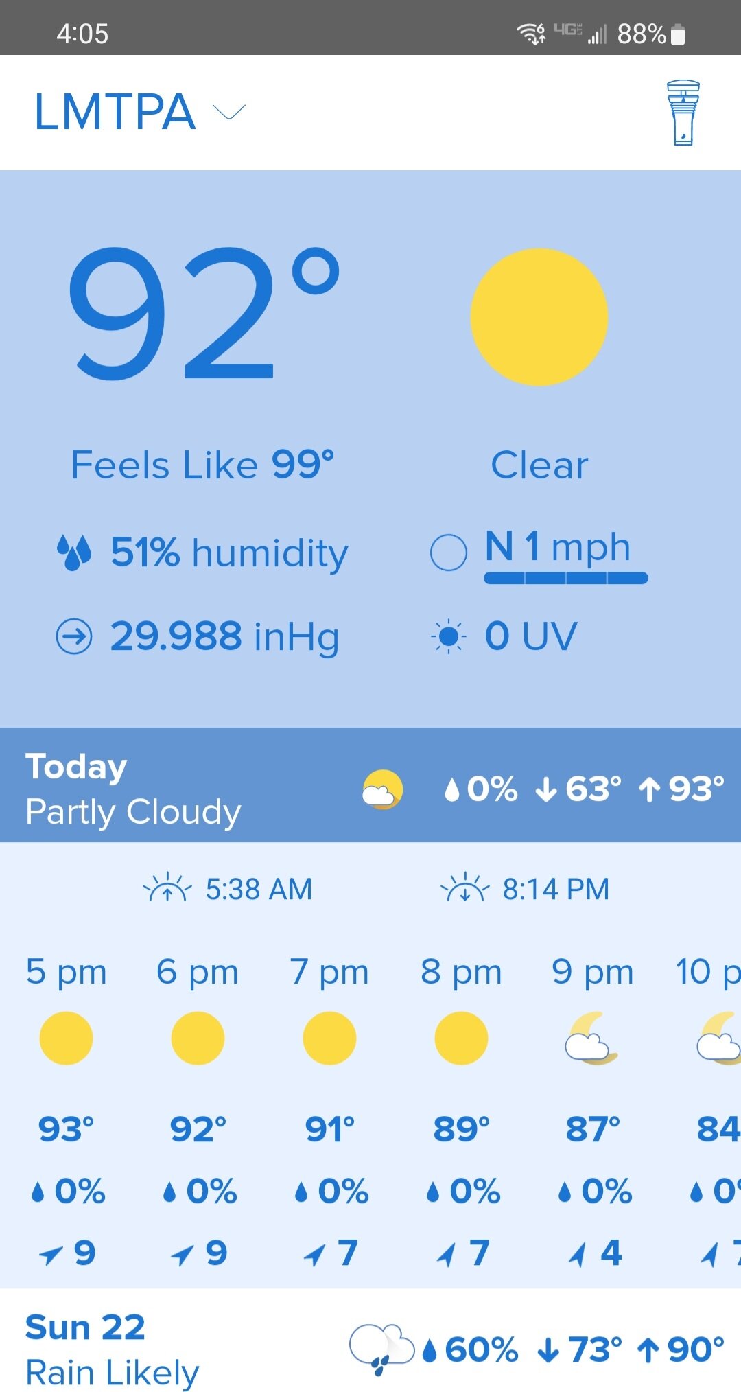
86 / 92 / 90 locally for 3 day summer preview. Just fine some of those GEM & GFS blast furnance runs didn't materialize.
-
95 at PHL & 93 ACY both tied the record for the date. Locally 92 for the high & also 92 at nearby TTN.
-
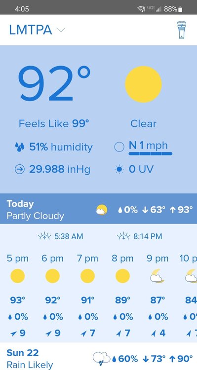
Toasty at 4:00, DP up to 72 now
-
Record May max temp at Philadelphia is 97 set during the epic 1991 torch. Heat came early & often that year, (21) 90 days before the start of calendar summer. (5) of those days were 95+ & (1) 100 day for good measure. Since 1990 the avearge date of the 1st 90 at PHL is 5/23, 1st 95 average date is 6/26.
-
If had a dollar for every one of radar looks like garbage posts before a significant event......
-
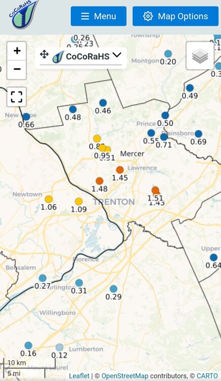
42 degrees at 10:30pm. CoCo gauge - 2.15" 50 degrees for the morning high today locally & at Trenton. 3rd lowest max temp for the date at Trenton behind 46 (1967) & 47 (1958). Long period of record at Trenton back to 1865. Temps in 40's all afternoon
-
I'm 10 miles NE of Philadelphia, high was 63 degrees.
-
Some heavy rain between 4:00-6:00am. Steady lightning & thunder for over an hour with a few house rattlers. 1.07", even more just to my north & east
-
25 degrees at Somerville this morning. Locally 30-32 degrees for locations with no wind. For nearby TTN this month will represent the 3rd below average April over the past 5 yrs. During that time frame the average April temp is down 3 degrees from the prior 2010-2017 period.
-
Locally, SE PA, the leaf out was running significantly eary until the pronounced late March cold shot pumped the brakes. Last 30 days are averaging around -1.7 degrees & I'd estimate currently around a week ahead a schedule thanks in large part to the 80 degree weather earlier this month. I've been out to New Hyde Park, Dix Hills & Bohemia enough in the spring to know its a whole different schedule out on the island.
-
PHL recorded a low of 32 degrees this morning, that ties 1983 for the 2nd coldest temp on the date & the coldest since 1875. This also represents the latest freeze at Philadelphia since 1988. Over the past 30 yrs. the average date of the last freeze at PHL is 3/31.
-
Can't quite put my finger on it but I could swear I've seen this post before.......
-
They ended up bottoming out at 4 degrees shortly after 7:00. At 3:00am it was 20 degrees, between 6:00-7:00 dropped from 15 to 5 degrees when the winds went calm.
-
DCA had over 10" during a Jan 2019 storm while Newark & Central Park recorded 0.1" & a T respectively. Technically not a shutout however about as close as you can get. Significant snow falls immediately following 60 degree days should be most common during late winter & early spring for our region. To have an event of this magnitude in early Jan following a top 10 warm Dec and the preceeding 5 days averaging 14-16 degrees above normal is beyond remarkable.
-
A little dramatic, 4 years ago is a little while but it's not back in the Ming dynasty
-
Dolts like you who obviously struggle with reading comprehension & can't even correctly spell the name of city they supposedly support aren't doing the print media any favors.
-
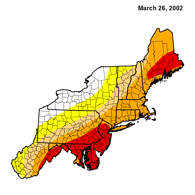
Wrong, severe / extreme drought conditions occurred during the fall of 2001 & peaked in the spring of 2002. This drought was worse than 1999 as the combined reservoir storage system reached record low levels. December 15, 2001 Combined storage in the NYC Delaware reservoir system drops to a record low level of 63.348 bg, or just 23.4% of capacity. This is more than 113 bg below normal storage levels for the date. https://www.state.nj.us/drbc/library/documents/02chronology.pdf https://www.nj.gov/drbc/library/documents/drought/DRBdrought-overview_feb2019.pdf

-
the donkey who is the supposed Pittsburgh fan can't even spell the city correctly, what a dolt another weak character front runner
-
The July EF-3 hit the Trevose section of Bensalem Township. The F3 damage occurred at a car dealership & neighboring mobile home park. This is the strongest tornado on record to hit Bucks County. Yesterday Bristol was hit by confirmed tornado that originated in S. Jersey.