dallen7908
-
Posts
960 -
Joined
-
Last visited
Content Type
Profiles
Blogs
Forums
American Weather
Media Demo
Store
Gallery
Everything posted by dallen7908
-
Mid-Atlantic forum winter 2021/22 snow totals thread
dallen7908 replied to North Balti Zen's topic in Mid Atlantic
1/3 7.5 1/7 2.25 1/16 2.25 1/28 0.5 12.5" for the year - likely just below the median for College Park with 6 weeks of chances to go -
January 28-29 2022 Miller abcdefu Storm Obs/Discussion
dallen7908 replied to mappy's topic in Mid Atlantic
First flurries in College Park -
January 28-29, 2022 Miller abcdefu Storm Threat
dallen7908 replied to WxUSAF's topic in Mid Atlantic
A primary purpose of the off hours runs is to provide initial and boundary conditions for European mesoscale models. -
Late January and February Medium/Long Range Discussion
dallen7908 replied to WinterWxLuvr's topic in Mid Atlantic
Who knows If this still exists as the weekly cycle in aerosol emissions is weaker than it used to be -
Thursday 1/20/22 Stat Padder Discussion and Observations
dallen7908 replied to stormtracker's topic in Mid Atlantic
Earlier today when I saw the 4" for your location, I was wondering if you had sent them a topographical shape file -
Thursday 1/20/22 Stat Padder Discussion and Observations
dallen7908 replied to stormtracker's topic in Mid Atlantic
It's a humbling reminder of how poor many drivers in this area are - that they feel the need to put out a "Percent Chance of 0.1 Snow" product. -
996 L over Tallahassee at 12 UT Sunday (Current run) 1006L over Jacksonville at 12 UT Sunday (00 UT run)
-
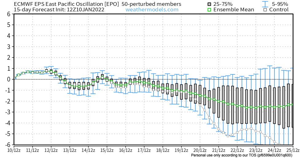
The EPO goes "way" negative week 2. Similar GEFS plot.
-
Good point - bad post by me. Why is the 12z GFS a dream in the extended? Verbatim, most of our area gets ~1" of snow during the next 384 hours. I assume you like the upper air pattern etc.
-
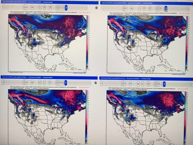
Where did all of our model snow go? Clockwise from upper left (18 UT yesterday, 00 UT today, 06 UT today, 12 UT today) Through 12 UT next Friday; GFS
-
Mid-Atlantic forum winter 2021/22 snow totals thread
dallen7908 replied to North Balti Zen's topic in Mid Atlantic
1/7/22 2.25" 9.75" for the season -
Mid-Atlantic forum winter 2021/22 snow totals thread
dallen7908 replied to North Balti Zen's topic in Mid Atlantic
"south" College Park 1/3/22 7.5" -
Cobb output for DCA from GFS (This would be one wild hour). Be skeptical, very skeptical ... YYMMDD FHr Wind SfcT Ptype SR |Snow||Sleet|| FZRA|| QPF 220103/12Z 24 02010KT 29.4F SNOW 15:1| 4.7|| 0.00|| 0.00|| 0.315 https://meteor.geol.iastate.edu/~ckarsten/cobb/cobb.php?model=gfs&site=kdca
-
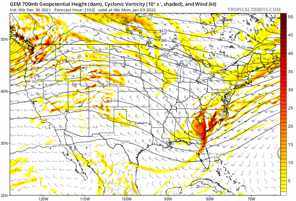
Trend at 700 hPa from the GEM; 36 hours ago DC was caught in the middle between the southern and northern streams. Now it is (forecast to be) well within the southwest flow associated with the SS. Winds over MO have shifted from northwesterly to north-northwesterly emphasizing the strengthening of the vorticity max; allowing for southwesterly rather than westerly flow to its east
-
From the Fearless Forecast on White Grass's home page: "While all-time records are never open-court slam dunks, our 3.0 inch lowest Canaan Valley 78-year record December snowfall record is truly in jeopardy of being broken this year. I anticipate very little if any more snow between now and when the books close for this month in 5 days on December 31." I guess I should have expected this when what I wanted for XMAS was a post-holiday trip to the Valley. Hopefully, "my" jinx ends before my planned XC skiing trip to upstate New York over MLK. I have the Laurentian mountains in mind for next winter ... Conditions will be wonderful today at the Center; trails 31, 32, 33, 34, 35, 37, Montée St-Hilaire, 11, 12, 13, 14 North, 31, loops 36-24 and Pont Georges and 25 will be available and groomed for both classic and skating. 5 Fat Bike run and 2 snowshoe paths will also be open.
-
3 of the 31 GEFS members give us measurable snow during that period with one of the members giving us 2 1/2". Let's watch this improve with time (I hope) 25% of the EPS members show a near-zero or slightly positive PNA by late on the 8th!
-
CPC is skeptical that any pattern change will be more than transient. After seasonal temperatures in week 2 (January 1-8), their 3-4 week outlook for January 8-21 (see link and below) suggests that the southeast ridge will be a bit muted in week 3 before strengthening once again in week 4. No reason for too much concern as they only give us a 55% chance of above normal (1990-2020) temperatures, which may be closer to a coin flip with respect to a mean centered on this year. https://www.cpc.ncep.noaa.gov/products/predictions/WK34/ "A manual blend of dynamical and statistical model guidance favors a continuation of the negative PNA and negative NAO patterns, showing up as a pair of ridges south of the Aleutians and over Greenland, and troughs over the West and the North Atlantic. A persistent ridge also remains over the Southeast, which is consistent with La Nina conditions. While the statistical guidance depicts more troughing and cold air intrusion into the eastern US, these tools are based on a more progressive and canonical MJO evolution than what is currently observed."
-
Yes it showed up on my YouTube feed. Hard to beat the 1993 storm in this area - didn't quite get to a foot of snow but being able to walk across the backyard on top of the snow/sleet drifts made up for it
-
While stretching this morning, I watched a fascinating documentary called the Storm of the Century: the Blizzard of 1949 by Wyoming PBS - a must watch if you love snow
-
Forecast highs from the GEFS and EPS for January 3-5th are predicted to be in the upper 30s for many of us. With above normal temperatures likely for the southeast, waves moving along the strong thermal gradient could be interesting - and maybe we'll be on the "right" side.
-
I'd feel quite a bit more optimistic if that was the model median as opposed to mean; I've never understood why they don't plot that instead
-
Perhaps in early January as the -NAO weakens while the EPO trends or remains slightly negative - certainly some precipitation chances
-
December 2021 Medium/Long Range Discussion Thread
dallen7908 replied to North Balti Zen's topic in Mid Atlantic
I know what follows is perambulating banter ... ... this reminded me of 7th grade when I was waiting at the scorers table to enter the game for the first time with 7 seconds left. Alas .. the coach did not call time out. The pitfall of being a 4th string point guard. ... but hey it's mid-December the equivalent of the 2nd inning if you'll excuse my shifting to a baseball analogy. I mean the atmosphere is like a tub of water right - at some point the cold water is bound to slosh our way - and we'll have our window... but for now all we can do is ooh-and-ah about a stout hour 360 -NAO, hope that the MJO will quit tarryng in 7 and head into 8, and look forward to how good the pattern 15-days past the 360-hour ensemble mean should be if past history during similar patterns holds. Keep the faith: with only a bit of luck by mid-January, a few moisture-starved systems will pass near us and we will be able to return to worrying about the exact location of the rain/snow line. -
December 2021 Medium/Long Range Discussion Thread
dallen7908 replied to North Balti Zen's topic in Mid Atlantic
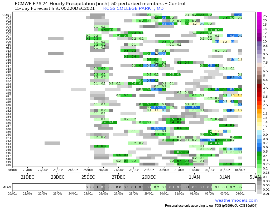
Crazy of him to event mention an "event" that would be 10-days away beginning on XMAS eve; an operational model has no skill 10-days out and ensembles are only useful for guidance as to whether or not there will be an east-coast event. But I couldn't resist: 5 of the 51 EPS members show snow on the 24th or 25th- with a maximum amount of ~1". -
December 2021 Medium/Long Range Discussion Thread
dallen7908 replied to North Balti Zen's topic in Mid Atlantic
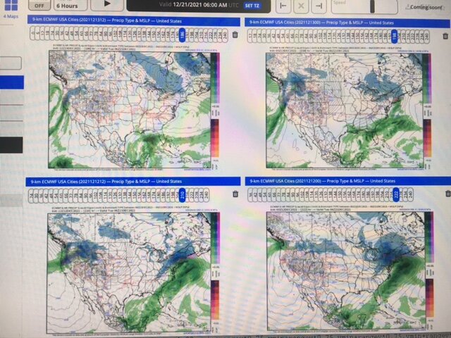
Last 4 runs of the EURO UL: 12 UT today. UR: 00 UT today LL: 12 UT yesterday; LR: 00 UT yesterday Next Monday's possible storm goes poof - for now