dallen7908
-
Posts
960 -
Joined
-
Last visited
Content Type
Profiles
Blogs
Forums
American Weather
Media Demo
Store
Gallery
Everything posted by dallen7908
-
Jan Medium/Long Range Disco: Winter is coming
dallen7908 replied to stormtracker's topic in Mid Atlantic
Yes, that storm track and area covered would be a dream come true for New England. It's been a brutal winter for the nordic resorts. Many of which have been closed since just before XMAS. Some never opened. Bretton Woods hasn't opened yet. Bolton Valley had early storms but never got around to laying down tracks and then ... Jackson, Mt. Van Hoevenberg, and Craftsbury have a few kms open - all man-made snow. -
Jan Medium/Long Range Disco: Winter is coming
dallen7908 replied to stormtracker's topic in Mid Atlantic
GFS shows a parade of storms - Drought may be over. Storm 1: Sat-Sun Storm 2: Tues-Wed Storm 3: Sat Storm 4 Tue Storm 5 Sat - that's the one currently "forecast" to give us low-landers snow. -
Less precipitation?

-
Regional models are very difficult to initialize and obtain boundary conditions for. They shouldn't be looked at in a vacuum. They are best when used as an ensemble member.
-
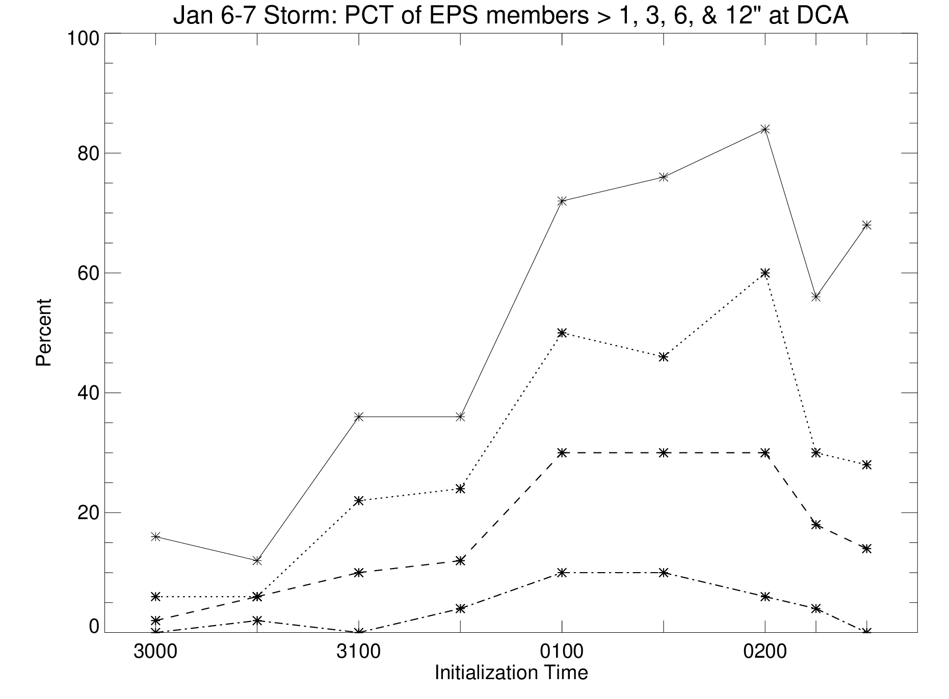
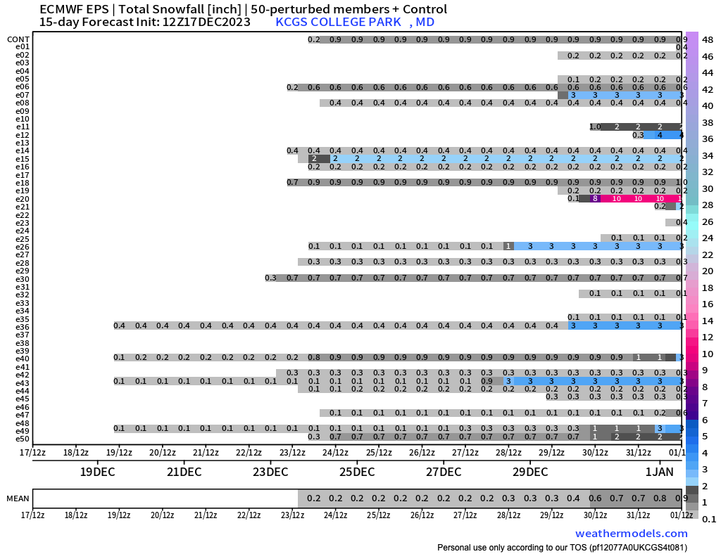
Final update on the probability time series at DCA. As you know this doesn't mean that DCA has a 60% chances of an inch or more of snow; typically 1" from the model corresponds to a few tenths in ground truth under marginal conditions. The 3" probability curve may better represent the chances of an inch or more of snow. In answer to someone's question from yesterday, I only did this for a location near DCA.
-
-
For DCA, the percent of 06 UTC EPS members giving DCA 1, 3, 6, and 12 inches of snow in the next 144 hours was 56, 30, 18, and 4%. The percentages for the 00 UTC run were 84, 60, 30, and 6.
-
Jan Medium/Long Range Disco: Winter is coming
dallen7908 replied to stormtracker's topic in Mid Atlantic
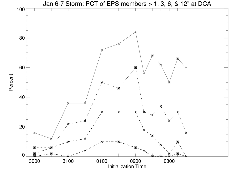
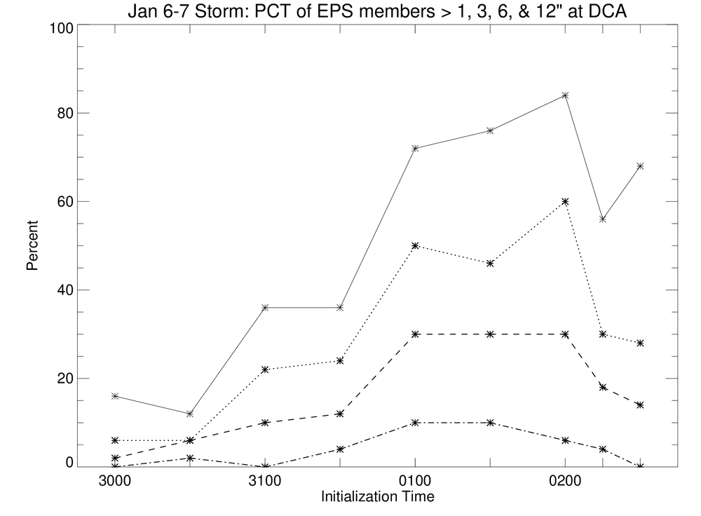
Percent of EPS members giving DCA >+ 1", 3", 6", and 12" of snow for upcoming period over the last 6 00 and 12 UTC runs (00 UTC on the 30th to 12 UTC on the 1st) 1" [16, 12, 36, 36, 72, 76] 3" [06, 06, 22, 24, 50, 46] 6" [02, 06, 10, 12, 30,30] 12"[00, 02, 00, 04, 10,10] -
Jan Medium/Long Range Disco: Winter is coming
dallen7908 replied to stormtracker's topic in Mid Atlantic
inch of snow ... and stay around long enough to give the weather observer at BWI a chance to measure it. -
Jan Medium/Long Range Disco: Winter is coming
dallen7908 replied to stormtracker's topic in Mid Atlantic
Thanks for the plot. Thoughts: 1) I wonder where he got the snow data for 1876-1895 or so. 2) February 8th for the mid-point - a few days later than I expected but certainly in line with memory. 3) The changes in slope are interesting do they just fall out of the data or did he do some piece-wise fitting? 4) The snowless gaps in late December and mid-January are a bit sad. 5) It looks like prime time is January 20th - February 20th - no surprise there! 6) I wonder how many winters are classified as moderate-to-strong El Niño winters and how different the plot would be during other years. Would the peak be a week earlier? -
If it's any comfort (as you know) our climatology gets reset every 10 years and I suspect at least one year in the 30's will top 10". Also, the warming of the oceans will likely slow in the near future as much of the sulfate has already been scrubbed and we'll only have greenhouse gases to blame. Plus if we live long enough the PDO will become favorable at some point. My concern is that if this continues, all of the "it could snow in this pattern" posters will get discouraged and we'll be left with a site filled with images from 300+ hour GFS runs. Wait ...
-
Jan Medium/Long Range Disco: Winter is coming
dallen7908 replied to stormtracker's topic in Mid Atlantic
Climatologically, ocean temperatures off of Ocean City are 48-53 in December, 42-47 in January, 41-44 in February, 42-46 in March, and 46-53 in April. So, the oceanic winter is just getting started. https://www.seatemperature.org/north-america/united-states/ocean-city-april.htm -
Some rule of thumbs for novice forecasters: Not the CAPE's, WxUSAF's PSU, etc. of the world Days 2.5-6.0 This is the time when major storms come into focus; look for run-to-run trends. Days 6-8 To avoid whiplash, look at the surface and 500 hPa presentations of the suite of operational runs once a day giving equal weights to the 00, 06, 12, and 18 UTC runs. Days 8-10: Look at the ensembles only (surface and 500 hPa). Are any storms showing up? When? Are at least a few producing snow? Days 10-12: Look at the 500 hPa pattern of the ensembles; snow totals are meaningless at this range (too much weight for climatology and outliers). Is this a pattern that could produce wintry weather? Days 12 and beyond: Is this a long-wave pattern when long-term forecasts are possible or is it best just to go with climatology adjusted for the base state (El Nino or La Nina)?
-
Way too early to give up on early January but here is the 3-4 week outlook beginning on the 6th. Features 55-60% chance of above normal temperatures and the same chances for above normal precipitation. It's a two outcome prediction so the chances of below normal temperatures is 40-45%. They note that the AO may go negative as early as mid-January if a SSW occurs. They believe the dominant forcer will be the strong ElNino and are not putting too much weight into the MJO due to large uncertainty. https://www.cpc.ncep.noaa.gov/products/predictions/WK34/
-
Well if there wasn't more than a little Ji in us we wouldn't be here 300 hours before game time
-
Yes, the 15-day mean in College Park is over an inch (1.1") for this first time this winter. We're entering a period when the modeled large-scale pattern is favorable and the climatology is less unfavorable. Hopefully, we get a few inches before we hear the word maritime continent again.
-
We rock. Perhaps we'll have a storm the first or second day the NAO goes negative!
-
... maybe it's just me but I hope the run comes to fruition and has snow. Despite the "best", "amazing", and "favorable" adjectives, the ensemble mean snow here for the next 15 days is less than 1". I'm certain the analogs are more favorable. ... and yes if the long wave pattern is favorable the snow may come. ... and of course, day 15 is just before our great period

-
https://www.cpc.ncep.noaa.gov/products/predictions/WK34/ Yesterday's NCEP forecast for weeks 3 and 4. Above normal temperatures likely for north-central and north-east U.S. with below normal temperatures in southeast. Transition to colder temperatures in northeast possible some time during week 4. MJO likely to weaken before reaching phase 8 but could re-emerge in 1. SSW could impact weather late in week 4 Impossible to predict whether NAO / AO will be positive or negative Widespread troughing over U.S. due to active storm track and not Arctic air mass intrusions.
-
White XMAS Hope lives for Canaan Valley and Mount PSU?
-
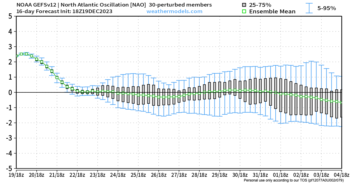
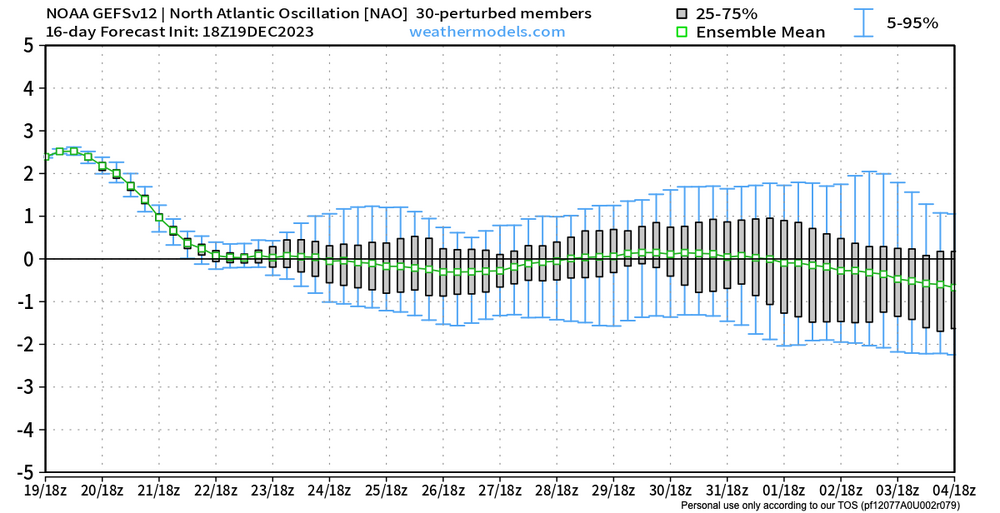
Yes, the PNA is positive during the last week of December but the NAO also remains positive. On the positive side, approximately 25% of the EPS and GEFS members show a neutral or slightly negative NAO during the last portion of the last week of December. I can't remember the last time there was anything to track during the December 27 - January 1st period. Hopefully, the ensemble 500 means are on to something.
-
I woke at 4:30 AM to snow and 33.9 degrees. After the snow stopped it briefly warmed up a half degree or so before cooling to 33.5 as it cleared just before dawn. Approximately 0.2" here in College Park.
-
Yes, I remember it being in the 60s earlier in the day, getting about an inch of rain and then coming out of an early Saturday evening mass with perhaps an inch of snow on the grass
-
I find it kind of pathetic that I'd be ecstatic if 4% of Sunday's predicted precipitation in my back yard (2.5" or so) falls as snow.
-
Arguably, the best EURO run yet for north and west of cities.