dallen7908
-
Posts
960 -
Joined
-
Last visited
Content Type
Profiles
Blogs
Forums
American Weather
Media Demo
Store
Gallery
Everything posted by dallen7908
-
The NWS forecast discussions out of Sterling are about to get more interesting - for snow lovers https://www.weather.gov/lwx/GarrettCecilTransfer
-
From the NWS discussion: Day IAD high/high min BWI high/high min DCA high/high min 11/8: 77(1987)/57(1977) 80(1975)/62(1975) 81(1975)/63(1975) 11/9: 78(1994)/56(1987) 78(1994)/61(1945) 79(1994)/64(1895) 11/10: 75(1985)/60(1966) 75(1999)/62(1966) 76(1999)/60(1975) 11/11: 78(2006)/55(2002) 77(2006)/59(1970) 78(1949)/58(1970)
-
https://frontierweather.dtn.com/WinterClimateDrivers.pdf Just in case you need background as to what a rising QBO value MAY mean for our winter weather.
-
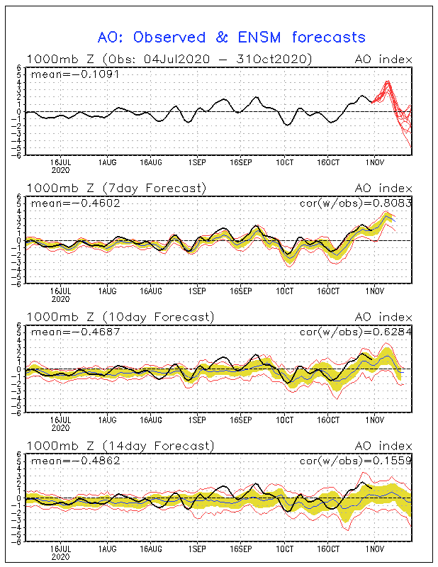
The high-bias in the forecast values reminds me of last winter. Could the bias be due to a poor coupling between the ocean model and the atmospheric model? On the positive side, the high-bias may allow some fantasy storms to come up the coast. On the negative side, reality will be much more mundane. Not that the AO forecast has much to say about it but I'm rooting for a warm November. My hunch is that the correlation between November temperatures and winter temperatures is negative - perhaps -0.02. I'll take any advantage I can get. A depressing truth; the "smartest" forecast might be to use the ensemble with the most positive AO value. Another depressing feature of the time series is that it goes negative about when the forecast skill goes to zero or at least to 0.16^2.

-
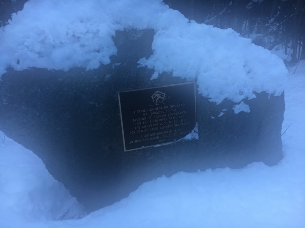
The climate change tangent got me thinking of nordic skiing and a sign I saw this past January. Hopefully "forever" won't end sooner than the Doucettes' hope
-
Looking forward to the cold but let's keep expectations in check given the climatology of the GFS
-
Looks like we may say goodbye to the 50s/60s beginning on the 6th with perhaps the highest 15-day snowfall mean from the EPS this season (3" with 2 HEC-like amount for immediate dC area) PNA negative throughout but some hope for a negative EPS too NAO positive for the next 10-14 days or so but could be negative late in the period Hopefully, this improving pattern has legs; however the 3-4 week outlook from CPC issued yesterday calls for above normal temperatures and precipitation.
-
I would be more discouraged if we wasted a -AO period during February. Sitting at 0.3" entering the New Year seems like the new normal inside the Beltway. Is it true that BWI is sitting at 0.1" or did they score a few tenths on another storm. Yes the extended range still looks to feature a ++AO, +NAO, neutral EPO, -PNA. Over days 6-10, 3 of 21 GEFS members and 3 of 51 EPS members give us 1" or more of snow. One EPS member gives us 7" during the January 2/3 time frame. Our 3 category chance of above normal temperatures is 40-50% for week 2 a far cry from the 70--80% hell we've seen during deep dark abysmal periods (DDAPS).
-
As last Friday's 3-4 week outlook said. "Intraseasonal variability in the tropics remains weak as there are still no strong MJO or other equatorial wave signals. The Indian Ocean Dipole remains strongly positive, although its amplitude has decreased by about 50% since the beginning of December. ENSO neutral conditions also persist; the SST anomalies in the Nino 1+2, 3, and 4 regions haven't changed much over the past month. Since there are no strong intraseasonal signals to use as Week 3/4 predictors, this forecast is based entirely on dynamical model guidance." Unfortunately, the EPS and GEFS (the dynamical model guidance) show a +NAO, ++EPO, +AO, and a slightly negative PNA during the first week of January. Bleak but does it really matter given this is not a window when it makes sense to make a week 3 forecast.
-
GEFS yes maybe, EPS no "Ambiguous" sum it up. Too far out there to matter.
-
Not according to the indices +NAO, +EPO (barely), +AO, -PNA for the early January period. Weak signal for New Year's eve storm
-
WRT to the cold CFS ... The following is part of the CPC 3-4 week outlook. Did the forecaster Kyle MacRitchie mean to say "over-forecasts cold in the Northeast" or am I missing something. Anyways they "forecast" a 50% (50%) chance of above (below) normal temperatures during week 3/4. They do forecast warmer than normal temperatures and precipitation over the southeast. The weenie in me says we could be on the cold end of something substantial. The ECMWF and JMA models, as well as a number of SubX models, forecast weaker troughing over Canada and suggest a warmer pattern over the eastern CONUS than the CFS does. Our calibration routine also lowers the cold probabilities in the CFS so that they appear more in-line with the ECMWF and JMA, which suggests that the CFS historically over-forecasts warmth in the Northeast.
-
Which is more likely, another December like this one or another February like last one? My hunch is that February 2015's weather was less abnormal but haven't run the statistics. Thoughts?
-
Remember Ian's article about how uncommon 1" and above snows are becoming at DCA. Well in today's Washington Post there is a non-technical article by Reid Wilson on California's drought that speculates that melting of Arctic ice may be 'contributing to a slowing of the jet stream contributing to colder wetter weather in the eastern U.S. and more persistently dry conditions in the west". I guess for every winner there is a loser. Kind of reminds me of spring 2010, when several hopeful posters here speculated that 2009/2010 could become the new norm or last winter when several scientific articles predicted that melting of Arctic ice could be responsible for warmer eastern U.S. winters and colder European winters.