dallen7908
-
Posts
960 -
Joined
-
Last visited
Content Type
Profiles
Blogs
Forums
American Weather
Media Demo
Store
Gallery
Everything posted by dallen7908
-
Feb Long Range Discussion (Day 3 and beyond) - MERGED
dallen7908 replied to WinterWxLuvr's topic in Mid Atlantic
00 UT EPS suggests that our best chance of snow is in a 2-day window beginning a week from Monday and ending a week from Wednesday. The EPS mean is 0.7" or greater for 4 consecutive 12-hour periods; a first for this season. Hopefully, my post tomorrow will be identical with the exception of the 0.7 being changed to 1" -
Wait ... we only need a 100% absolutely dead perfect textbook pattern. I thought we needed a storm during that ephemeral window too. Seriously, many of the the myriad things we need to get a substantial snow are highly correlated with each other so at some point things will improve rapidly. Hard not to think that luck has been lacking lately when we hear about snows in Texas, Oklahoma, Madrid etc. Its kind of amusing to be rooting for flow from Canada and when it comes several alert posters point out both graphically and with numbers that it is of Pacific origin - Those posts and the wonderful analysis by you and others makes this an enjoyable forum. Also, I encourage members to spend a few days each winter in northern New England and to track the weather at your destination several weeks in advance. Very rewarding. Unfortunately, this winter, a few trips to White Grass may have to suffice for me. On to the 12UT suite, hopefully, we can all meet in the 3-7 day forum soon ...
-
As snowdreamer noted, the best chance of snow in MBY according to the EPS is on the 20th - could be fun to watch the ... REMINDER: NO ... While there is nothing through the medium-range, the 15 day mean of 2 - 2 1/2 inches is higher than its been in quite a while. The 20th is roughly when the PNA is forecast to go negative for a while.
-
Even if that is the case there will be a window perhaps D10-D15 for an HA event or more likely just a wintry storm as the AO/NAO rise from very low levels and the PNA falls.
-
Certainly exciting to see that we have multiple chances of snow next week. However, the EPS mean for most of us continues to be stuck at ~2". The 10th and 90th percentile EPS "goal posts" for College Park, Frederick, and Camp David are 0-5", 0-3", and 0-4" of snow/sleet. While the NAO looks to remain negative for the foreseeable future it is "relaxing" towards neutral beginning mid-month. The AO continues negative with only a hint at moving towards neutral. The PNA pattern is solid positive (favorable for snow) through mid-month and then plummets. Hopefully, the time period when it begins to decline will excite snow- and acronym (HA) lovers.
-
Isn't this the time for someone to tell us that an HA storm is not in the cards because the NAO rise from -3.5 to -2 between the 5th and 12th is too slow.
-
In case anyone is hoping that changing to 1991-2020 for the new climatological baseline will help us get cold anomalies next week and later this winter - the shift won't occur until sometime this spring - May? In case anyone is hoping increased cold anomalies due to the new baseline will improve our chances of getting snow ... I have a bridge to sell you
-
... but the impressive WAFz spans the troposphere and stratosphere suggesting that the upcoming SSW is occurring in an atmosphere pre-disposed to troposphere-stratosphere coupling, which may make the winter storm track further south than normal either here or in Asia as early as the last week of January - perhaps that elusive HA storm - given how low and stable the NAO/AO are forecast to be. ... Alternatively, we can skip the acronyms and focus on the January 3/4 period
-
Merry Christmas all. It can only get better from here.
-
Please move all 10-day EURO plots to the digital snow forum - Only half kidding. What I'd give to live in a world where the 10-day EURO map was climatology
-
I wonder when this will be .. The AO and NAO look stable and negative for the last few days of 2020 and the first week of 2021. The DC-proper snow means from the GEFS and EPS for the next 10-15 days are less than 1" (below the 2" amount that is typical this time of year) The good news is the large-scale pattern is not close-the-window-shades bad. Its been a decade since we've had anything in the mid-range to track in late December - still a chance this year.
-
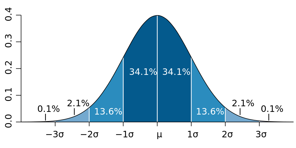
five-sigma corresponds to about 1 in 3.5 million assuming a normal distribution So if we hear discussion of another 4 or 5 sigma event we should consider the source and/or unfollow Kayleigh McEnany
-
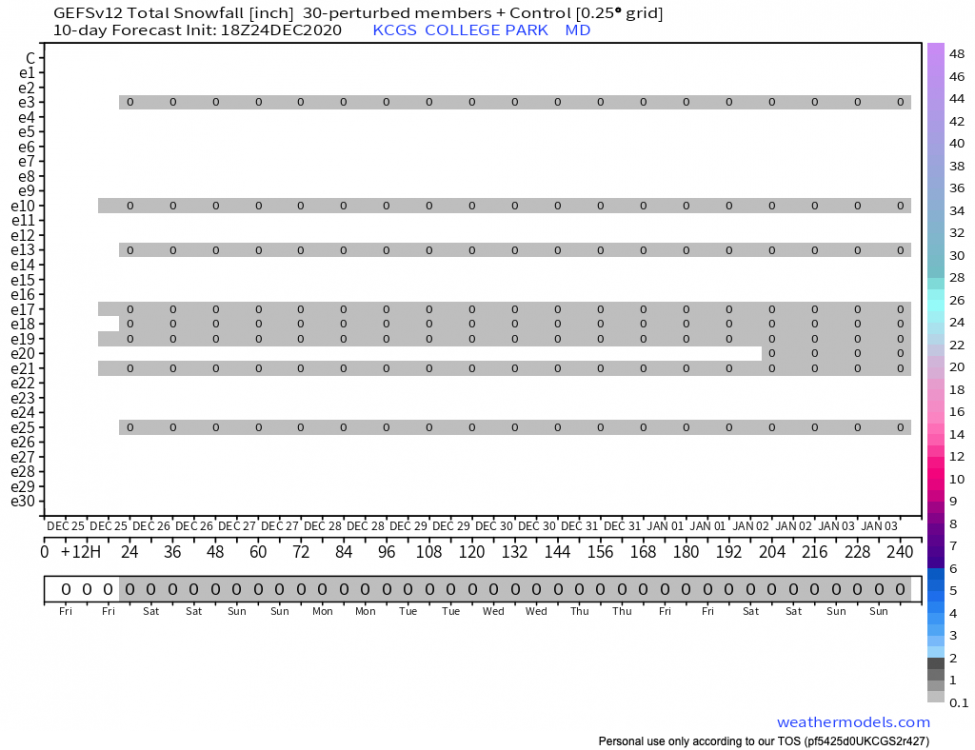
Just over 10% of the EPS members look promising for XMAS. Here is an extreme example.
-
12/16 0.6 " (College Park)
-
December 16-17, 2020 Winter Storm Obs/Nowcasting
dallen7908 replied to WxUSAF's topic in Mid Atlantic
Finished? with 0.7" here in College Park - changed from snow to sleet to rain within the last hour. Surface temperature 32.4 -
December 16-17, 2020 Winter Storm Obs/Nowcasting
dallen7908 replied to WxUSAF's topic in Mid Atlantic
Yes it shifted from sleet to light snow about 10 minutes ago. 32.9 degrees -
December 16-17, 2020 Winter Storm Obs/Nowcasting
dallen7908 replied to WxUSAF's topic in Mid Atlantic
Been sleeting in College Park for the last 5-10 minutes -
December 16-17, 2020 Winter Storm Obs/Nowcasting
dallen7908 replied to WxUSAF's topic in Mid Atlantic
Slowly rising surface temperature here. 29.7 at 6:40, 30.6 at 7:30, and now 31.5F -
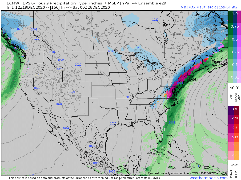
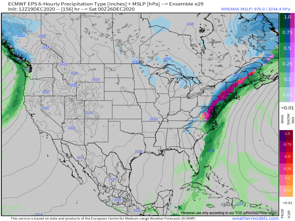
Euro 6z: Verbatim (without looking at the soundings), Similar or very slight worse than 00 UT, for DC it shows snow beginning between 11 AM and noon changing to mixed precipitation between 2 and 3, surface temperature of 34 degrees. Snow maximum still in central PA - just under 2 feet
-
In case anyone is wondering GDPS on the pivotal weather plot is the acronym for the operational "Canadian" model.
-
GOOD CHANCE OF 1ST LIGHT SNOW EVENT VA / nw NC/ MD DEL MONDAY DEC 7
dallen7908 replied to DTWXRISK's topic in Mid Atlantic
Are the ensembles still based off of the old GFS? If yes, it's less staggering -
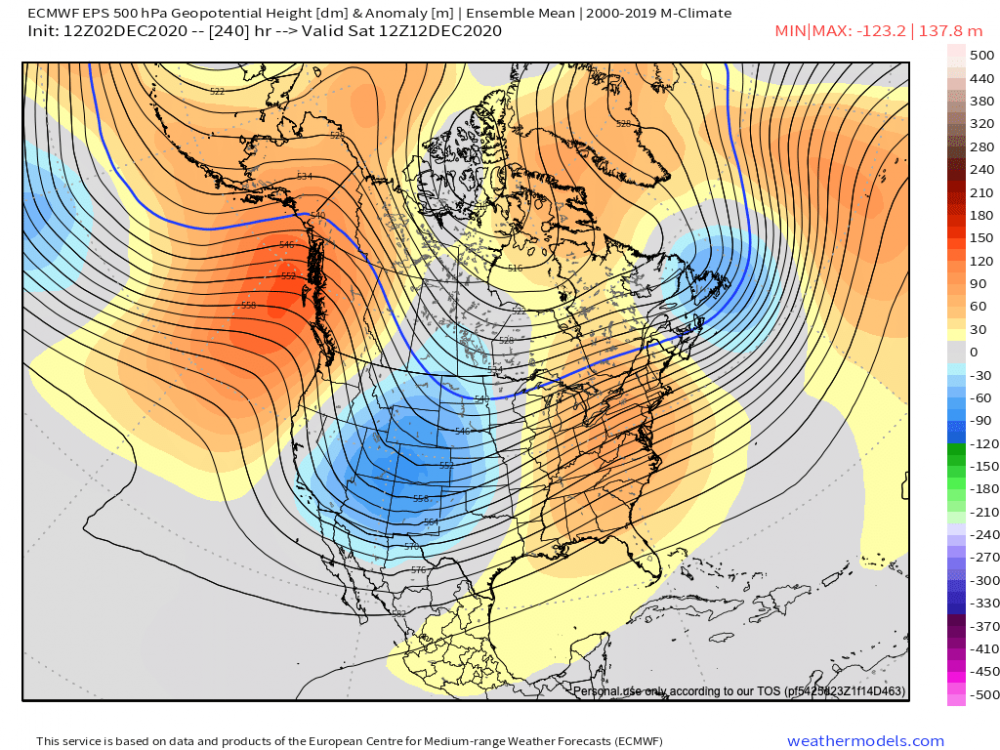
For comparison purposes here is the EPS panel, superficially they look similar ... although SE ridge is much stronger here - 50 N low too far east to help us?
-
How about this ... the EPS shows a positive EPO for much of this period while the CPC 3-4 week outlook gives us a > 60% chance of above normal temperatures as La Nina reasserts itself.
-
Based on my limited knowledge of this ... Warmings have strong correlation with winter temperatures in Europe; not so much in the northeastern U.S.. We'll have to wait and see. In any case, probably not much of a factor until mid-December
-
Saint Martin's summer; would use the more familiar Indian summer - if my back yard had experienced a freeze