dallen7908
-
Posts
960 -
Joined
-
Last visited
Content Type
Profiles
Blogs
Forums
American Weather
Media Demo
Store
Gallery
Everything posted by dallen7908
-
December 2021 Medium/Long Range Discussion Thread
dallen7908 replied to North Balti Zen's topic in Mid Atlantic
Whenever PSU goes on this rant, it always reminds me of skill score. A skill score measures the accuracy of a forecast with reference to the accuracy of a standard forecast. The standard forecast is usually but not always a forecast that is available to a forecaster, and which does not require any effort or knowledge on his part to prepare. For example, a forecast which consists of the climatological average temperature for a particular station for each day can be obtained from climatological tables and doesn't require any knowledge of the current weather situation to prepare. More significant digits, more ensembles, or a better model might help (a very little) but this doesn't look encouraging for us low landers..thumb.png.009c99c7543ec64f5a41983fe13ce93c.png)
-
December 2021 Medium/Long Range Discussion Thread
dallen7908 replied to North Balti Zen's topic in Mid Atlantic
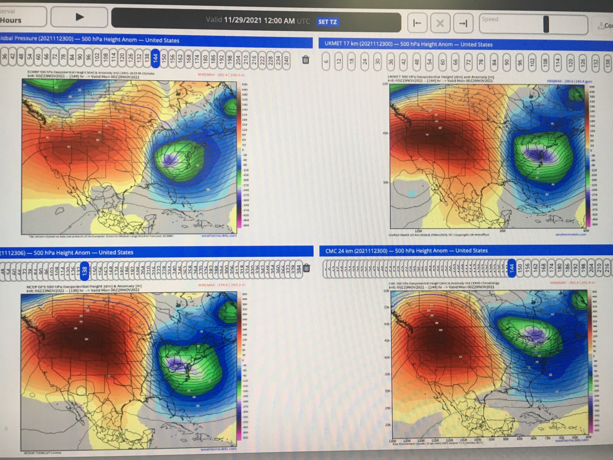
06 UT Thursday morning. EURO is in UL, GFS UR, CMC LR, UKMET LL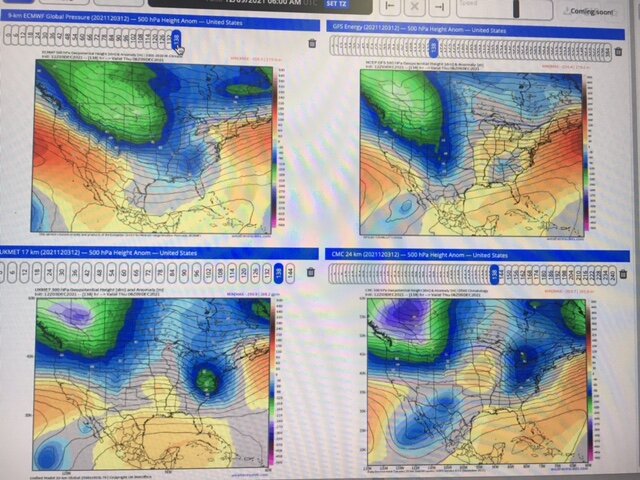
-
December 2021 Medium/Long Range Discussion Thread
dallen7908 replied to North Balti Zen's topic in Mid Atlantic
A blurry look at next Wednesday's system. Clockwise from upper left: EURO, GFS, CMC, and UKMET. Hopefully, the UKMET is on to something ...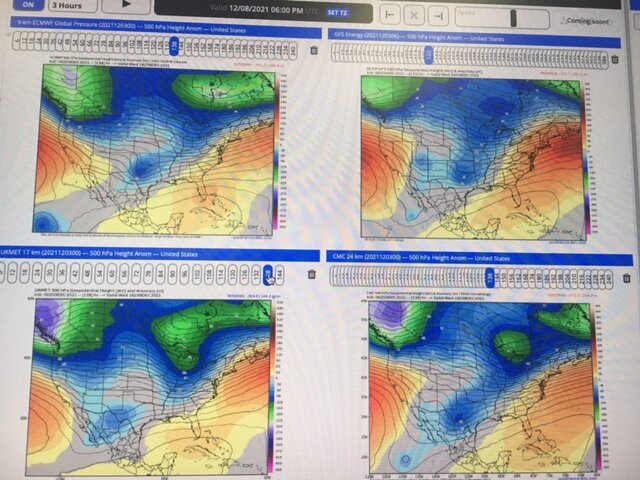
-
December 2021 Medium/Long Range Discussion Thread
dallen7908 replied to North Balti Zen's topic in Mid Atlantic
At this time ... Very limited ensemble support from the 06 UT GEFS for a West Virginia/ Pennsylvania storm next Monday; no support for the DC area. No operational support. Plots shown at 12Z on Monday: UL EURO, UR GFS, LL CMC, LR Korean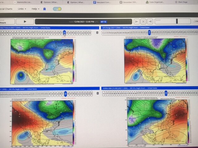
-
December 2021 Medium/Long Range Discussion Thread
dallen7908 replied to North Balti Zen's topic in Mid Atlantic
Here is a preprint of a recent un-reviewed article on the impact of SSW on European winter weather. Worth the skim. https://eartharxiv.org/repository/view/2206/ -
December 2021 Medium/Long Range Discussion Thread
dallen7908 replied to North Balti Zen's topic in Mid Atlantic
Monday's "event". ECMWF, UKMET, GFS, and CMC
-
December 2021 Medium/Long Range Discussion Thread
dallen7908 replied to North Balti Zen's topic in Mid Atlantic
I don't know about that but these type of patterns must excite the Ottawa weenies - visions of another 200 cm winter -
Any thoughts on the pros and cons of various premium weather sites. Which would make sense for personal tracking of snow (or in my case usually mixed events). WeatherBELL.com weather models.com accuweather.com etc. Other I have an advanced degree in meteorology but this would be for personal use; specifically tracking winter storms via ensembles. I've used weather models.com in the past and may continue to do so but am wondering if there are advantages to going with WeatherBELL.com etc. I believe WeatherBELL.com is a bit more expensive $25/mo vs. $15/mo for weather models.com. I suspect weatherbell.com gets their ECMWF output quicker but am uncertain. I've used accuweather in the past when our Department had an account.
-
Graupel in College Park too (not much)
-
What's stunning to me is that we've been tracking nearly non-stop this winter. Before this current period, a harbinger of spring?, the only comparable period with nothing to track was the last 10 or so days of December and that period ended earlier than expected. The EPS did an amazing job of sniffing out medium-range threats (European Center for MEDIUM Range Weather Forecasting). Unfortunately, their decision to add 06 and 18 UT runs to provide boundary conditions for (European) mesoscale models proved to be justified and necessary; the Euro did poorly within 3-days on the one metric that matters to many in this forum. The NAM was annoyingly right for the wrong reasons beyond 48 hours but an important tool within 48-hours. During the 2020-21 winter, those warm layers are insidious/surreptitious/stealthy (insert your favorite adjective) and if one model shows a warm layer in Fredericksburg prepare for sleet in Frederick. Snow forecasts from the GFSv16 were useless. Hopefully, this can be fixed with a few tweaks to the diagnostics. Last I checked snow amount wasn't a prognostic variable! Hopefully, this current period is short and we'll be tracking a last hurrah (for our northern and western members?) soon.
-
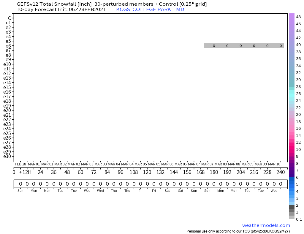
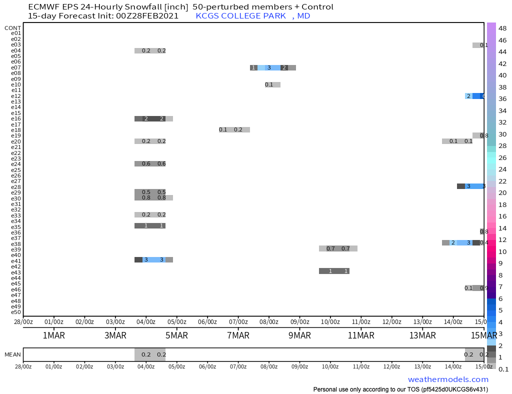
For once, the GEFSv12 and EPS members are (likely) not overestimating the DC-area's snow chances over the next 10-15 days. Keep in mind that the EPS values are shown every 12-hours for 24-hour periods so divide by 2. The values for the GFS are total for the entire period.


-
It's still February! I'm at 38.97519N 76.93796W. Sadly further south than even the CP airport.
-
00 UT EPS mean snow fall for College Park over the next 15 days is 1", likely an inch below climatology. To put it another way, the EPS "predicts" that 4% of a predicted 2.3" of precipitation during the next 15 days will be snow/sleet. Pathetic but if forced to put down money I'd take the ... The EPS mean (median) snow/sleet for the February 28 storm is 0.1 (0.0)" The same values for the March 3/4 storm are 0.4 (0.0)". One ensemble member shows a HECS March 10-12. The 18+" from that storm is the main contributor to the 1" mean. Could be fun.
-
12/16 0.6" 1/25 0.4" 1/31 2.0" 2/1 0.25" 2/2 1.25" 2/7 0.1" 2/10-2/11 0.4" 2/18 0.8" 2/19 0.2" 2/22 0.2" 6.2" for the season (College Park)
-
0.2"* in College Park - before changing back to sleet and now rain/sleet mix *Its kind of silly but I have a ruler on the ledge of the fireplace and run out and measure as soon as the transition(s) begin All about maximizing one's snow totals Now over 6" for the winter - close to 50% of median
-
Certainly a cold morning here but I wonder how much colder it would have been if the ground were white and not brown. Friday's relative warmth and Saturday's sun were enough to melt the (almost) 1" I received - at least in non-shady areas. Quite the contrast with the few of you to the north who have had full snow cover for several weeks Likely comes down to rates - an inch or two of snow is only a few tenths of precipitation - it could happen
-
Strong support from the 00UT EPS for a minor event Monday evening - 44 of the 51 members give measurable snow/sleet in College Park. what could possibly go wrong? 90th percentile: 2" 80th percentile: 2" 70th percentile: 1" 60th percentile: 1" 50th percentile: 0.9" 40th percentile: 0.6" 30th percentile: 0.4" 20th percentile: 0.2" 10th percentile: 0.0" Keep in mind these are for College Park; your backyard could do a bit better. Also, do not apply the (EPS-3)*2/3 rule, which has worked so well this winter. It works best with a 24-hour forecast and has not been tested yet during this period of shorter wavelengths and colder climatological SSTs.
-
Sleet / snow mix in College Park
-
12/16 0.6" 1/25 0.4" 1/31 2.0" 2/1 0.25" 2/2 1.25" 2/7 0.1" 2/10-2/11 0.4" 2/18 0.8" 2/19 0.2" 6.0" for the season (College Park)
-
Sleet dancing on the bushes like popcorn in a popcorn popper. 29 degrees here. Dusting of snow very early followed by sleet/freezing rain mix
-
Feb Long Range Discussion (Day 3 and beyond) - MERGED
dallen7908 replied to WinterWxLuvr's topic in Mid Atlantic
*The storm that caused the NWS to reconsider its decision to retire the NAM or why one shouldn't look at mesoscale output until within 48 hours? *Just kidding of course, it isn't really being retired because of performance -
Feb Long Range Discussion (Day 3 and beyond) - MERGED
dallen7908 replied to WinterWxLuvr's topic in Mid Atlantic
The NAM showed an ugly warm nose near 700 hPa. Here is a time series showing 700 hPa temperature trends for several runs of the GFS-Parallel for 1 PM Thursday afternoon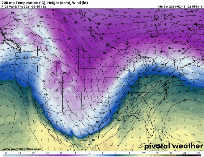
-
Feb Long Range Discussion (Day 3 and beyond) - MERGED
dallen7908 replied to WinterWxLuvr's topic in Mid Atlantic
Fun to watch the heights over the eastern U.S. get beaten down and the push of the TPV into the Dakotas. Wintry mix incoming for many of us (duh).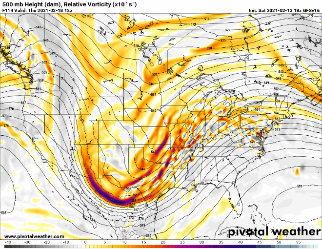
-
If 0.02" and cold surfaces/air temperatures is a high-impact event shouldn't the criterium for ice storm warning be changed; I thought 0.02" without sleet/snow is an ice storm advisory
-
12/16 0.6" 1/25 0.4" 1/31 2.0" 2/1 0.25" 2/2 1.25" 2/7 0.1" 2/10-2/11 0.4" 5.0" for the season (College Park)
.png.3e7895ce9796d546e0f514a5e295935b.png)