dallen7908
-
Posts
960 -
Joined
-
Last visited
Content Type
Profiles
Blogs
Forums
American Weather
Media Demo
Store
Gallery
Everything posted by dallen7908
-
March Medium/Long Range Thread: The Empire Strikes Back
dallen7908 replied to stormtracker's topic in Mid Atlantic
In the Baltimore area there have been 102 snows storms with one-day totals exceeding 6 inches. Of those, 21 occurred in March or April. Of the 21, 12 occurred during the first 10 days of March, 6 during the next 10 days, and 3 occurred on the 21st or later. In the DC area there have been 79 snow storms with one-day totals exceeding 6 inches. Of those 10 occurred in March. Of those 10, 4 occurred during the first 10 days, 3 during the next 10 days, and 3 on the 21st or later. The Palm Sunday storm topped the chart at both locations (22 and 11.5 inches, respectively). Our window is short. -
Courtesy of the Penobscot Marine MuseumDuring the cold winter of 1904-1905, Mainers enjoyed taking horse-drawn sleighs across the frozen expanse of Belfast Harbor to check out the Monument, a nautical marker that is at least a half mile from land.
-
https://www.cecildaily.com/our_cecil/the-wild-winter-weather-of-1905/article_1be60139-4065-59f4-a056-1535ee55dcd6.html
-
Rank is based on (Inches of Snow) + (Days with >=1" on the ground) + (Days with mean T <=32) + (24hrsnow-5)*0.5. The latter is a big storm bonus. Washington Area Rank YYYY-YYYY Points Inches Days>1"G Days<32M BigSB Grade 1 1904-1905 158.2 41.0 55 61 1.2 A+ 2 1917-1918 151.4 38.9 51 58 3.5 A+ 3 1898-1899 138.2 54.4 33 46 4.9 A 4 1960-1961 132.1 40.3 44 43 4.8 A 5 2009-2010 126.6 56.1 30 29 11.5 A- 6 1903-1904 119.6 20.2 30 69 0.5 B+ 7 1995-1996 116.3 46.0 25 40 5.3 B+ 8 1921-1922 115.5 44.5 30 33 8.0 B+ 9 1935-1936 113.5 32.8 29 47 4.7 B+ 10 1933-1934 112.4 30.7 32 48 1.7 B+ 11 2002-2003 112.2 40.4 28 39 4.9 B+ 12 1910-1911 109.3 39.8 29 40 0.5 B+ 13 1894-1895 108.5 24.8 39 44 0.7 B+ 14 1911-1912 102.5 21.8 31 49 0.7 B 15 1978-1979 99.2 37.7 23 33 5.5 B 16 1899-1900 98.5 35.6 22 37 3.8 B 17 1919-1920 98.4 17.4 29 52 0.0 B 18 1966-1967 97.5 37.1 26 30 4.4 B 19 1939-1940 96.7 25.3 28 41 2.4 B 20 1977-1978 95.7 22.7 25 48 0.0 B- 21 1962-1963 95.0 21.4 27 46 0.5 B- 22 1963-1964 94.9 33.6 28 31 2.2 B- 23 1957-1958 94.4 40.4 16 31 7.0 B- 24 1947-1948 92.8 23.5 22 47 0.3 B- 25 1908-1909 92.3 36.0 29 23 4.3 B- 26 1934-1935 88.8 31.4 26 28 3.4 B- 27 1913-1914 86.6 28.6 21 37 0.0 B- 28 1906-1907 85.3 28.3 18 39 0.0 B- 29 1929-1930 84.7 20.4 22 39 3.2 B- 30 1976-1977 83.1 11.1 24 48 0.0 C+ Rank YYYY-YYYY Points Inches Days>1"G Days<32M BigSB Grade 31 2013-2014 82.6 32.0 20 30 0.5 C+ 32 1924-1925 82.5 18.5 28 36 0.0 C+ 33 1901-1902 82.1 13.1 20 49 0.0 C+ 34 1987-1988 81.0 25.0 22 30 4.0 C+ 35 1965-1966 80.9 28.4 18 30 4.5 C+ 36 1967-1968 77.4 21.4 18 37 1.0 C+ 37 1909-1910 77.0 20.0 19 38 0.0 C+ 38 1905-1906 77.0 25.7 15 36 0.3 C+ 39 1981-1982 73.2 22.5 22 28 0.8 C+ 40 1959-1960 72.8 24.3 17 30 1.5 C+ 41 1925-1926 72.6 17.4 17 36 2.2 C+ 42 1915-1916 69.4 17.4 14 38 0.0 C 43 1993-1994 69.2 13.2 23 33 0.0 C 44 1916-1917 68.8 18.8 13 37 0.0 C 45 1896-1897 68.2 16.2 13 39 0.0 C 46 1893-1894 68.2 25.4 13 29 0.8 C 47 1900-1901 68.1 9.1 9 50 0.0 C 48 1986-1987 68.0 31.1 17 16 3.9 C 49 1945-1946 67.6 21.6 16 30 0.0 C 50 1989-1990 67.3 15.3 24 28 0.0 C 51 1907-1908 67.3 18.3 14 35 0.0 C 52 1964-1965 64.1 17.1 15 32 0.0 C 53 1946-1947 63.5 20.0 13 29 1.6 C 54 1985-1986 63.4 15.4 14 34 0.0 C 55 1932-1933 63.0 23.8 15 21 3.2 C 56 1914-1915 62.5 14.5 12 36 0.0 C 57 2014-2015 62.3 18.3 16 28 0.0 C 58 1982-1983 62.2 27.6 13 15 6.6 C 59 1999-2000 60.7 15.4 20 23 2.2 C 60 1961-1962 60.0 15.0 14 31 0.0 C Rank YYYY-YYYY Points Inches Days>1"G Days<32M BigSB Grade 61 1940-1941 58.7 17.9 8 31 1.8 C- 62 1923-1924 58.2 21.9 9 27 0.3 C- 63 1979-1980 56.1 20.1 14 22 0.0 C- 64 1969-1970 56.0 14.0 13 29 0.0 C- 65 2003-2004 55.4 12.4 15 28 0.0 C- 66 1955-1956 55.3 11.3 6 38 0.0 C- 67 1938-1939 55.0 15.1 15 24 1.0 C- 68 2004-2005 54.5 12.5 11 31 0.0 C- 69 2015-2016 54.2 22.2 11 17 4.1 C- 70 1970-1971 52.7 11.7 6 35 0.0 C- 71 1983-1984 52.6 8.6 11 33 0.0 C- 72 2006-2007 52.5 9.5 11 32 0.0 C- 73 1942-1943 52.5 20.5 0 32 0.0 C- 74 1927-1928 50.3 13.6 9 25 2.8 C- 75 1922-1923 49.7 15.7 5 29 0.0 C- 76 1953-1954 49.6 18.0 11 19 1.6 C- 77 1936-1937 48.7 20.2 8 20 0.5 C- 78 1902-1903 48.2 8.2 9 31 0.0 C- 79 1895-1896 47.3 9.3 7 31 0.0 D+ 80 2010-2011 47.1 10.1 10 27 0.0 D+ 81 1984-1985 46.3 10.3 9 27 0.0 D+ 82 1897-1898 46.0 11.0 7 28 0.0 D+ 83 1928-1929 45.5 8.0 4 32 1.5 D+ 84 2000-2001 44.4 7.4 6 31 0.0 D+ 85 1968-1969 44.1 9.1 4 31 0.0 D+ 86 1958-1959 42.9 4.9 3 35 0.0 D+ 87 1971-1972 42.2 16.8 6 19 0.5 D+ 88 1956-1957 42.2 14.2 10 18 0.0 D+ 89 1941-1942 41.8 13.6 0 25 3.2 D+ 90 1944-1945 41.8 7.8 0 34 0.0 D+ Rank YYYY-YYYY Points Inches Days>1"G Days<32M BigSB Grade 91 2008-2009 41.5 7.5 5 29 0.0 D+ 92 1926-1927 41.3 4.3 9 28 0.0 D+ 93 1950-1951 41.2 10.2 7 24 0.0 D+ 94 1992-1993 39.6 11.7 7 20 0.9 D+ 95 1998-1999 39.3 11.6 4 22 1.8 D+ 96 2018-2019 38.7 16.9 9 11 1.8 D+ 97 1973-1974 38.4 16.7 9 12 0.7 D+ 98 2021-2022 38.2 13.2 6 18 1.0 D+ 99 1994-1995 37.1 10.1 10 17 0.0 D+ 100 1943-1944 36.7 7.7 0 29 0.0 D+ 101 1937-1938 36.3 5.3 4 27 0.0 D+ 102 2005-2006 35.5 13.6 6 15 1.0 D 103 1980-1981 35.5 4.5 3 28 0.0 D 104 1954-1955 34.6 6.6 4 24 0.0 D 105 2017-2018 33.8 7.8 4 22 0.0 D 106 1912-1913 33.5 8.7 5 19 0.8 D 107 1948-1949 33.3 15.8 7 10 0.5 D 108 1920-1921 32.8 6.8 4 22 0.0 D 109 1951-1952 29.2 10.2 3 16 0.0 D 110 1988-1989 28.7 5.7 2 21 0.0 D 111 1930-1931 28.5 2.5 3 23 0.0 D 112 1991-1992 27.6 6.6 4 17 0.0 D 113 1974-1975 24.8 12.8 5 7 0.0 D 114 1952-1953 23.3 8.3 5 10 0.0 D- 115 1931-1932 23.0 5.0 4 14 0.0 D- 116 1996-1997 22.7 6.7 4 12 0.0 D- 117 2020-2021 22.4 5.4 3 14 0.0 D- 118 1975-1976 22.2 2.2 1 19 0.0 D- 119 1990-1991 22.1 8.1 4 10 0.0 D- 120 2007-2008 21.9 4.9 4 13 0.0 D- Rank YYYY-YYYY Points Inches Days>1"G Days<32M BigSB Grade 121 1972-1973 21.1 0.1 0 21 0.0 D- 122 1918-1919 19.3 3.3 0 16 0.0 D- 123 2016-2017 18.4 3.4 4 11 0.0 D- 124 1949-1950 16.4 3.4 1 12 0.0 D- 125 2012-2013 15.1 3.1 1 11 0.0 D- 126 2001-2002 13.2 3.2 1 9 0.0 D- 127 2011-2012 9.0 2.0 1 6 0.0 F 128 2019-2020 6.6 0.6 0 6 0.0 F 129 2022-2023 5.4 0.4 0 5 0.0 F 130 1997-1998 5.1 0.1 0 5 0.0 F
-
Baltimore winters ranked from 1-130 . This could be the first Baltimore winter with fewer than 10 days with mean temperatures of 32 or below. We need some serious March snow to avoid the worst winter ever (for members of this forum!) based on this metric. Ranking is based on (inches of snow) + (days with >=1" of snow on the ground) + (days with mean T <=32) + Bigstorm bonus ([24hr_inches - 5 inches]*0.5) Baltimore Area Rank YYYY-YYYY Points Inches Days>1"G Days<32M BigSB Grade 1 2009-2010 176.8 77.0 35 46 18.8 A+ 2 2002-2003 168.8 58.1 42 59 9.7 A+ 3 1904-1905 161.2 42.0 56 61 2.2 A+ 4 1960-1961 151.4 46.5 49 50 6.0 A+ 5 1933-1934 150.0 49.6 46 51 3.3 A+ 6 1995-1996 148.9 62.5 28 49 9.4 A+ 7 1917-1918 135.5 35.4 39 58 3.1 A 8 1898-1899 131.1 51.1 30 44 6.0 A- 9 1903-1904 130.4 25.9 34 70 0.5 A- 10 1977-1978 128.1 34.3 28 64 1.8 A- 11 1963-1964 127.2 51.8 26 42 7.4 A- 12 2013-2014 124.3 39.0 25 58 2.3 A- 13 1935-1936 118.9 31.7 41 45 1.2 B+ 14 1966-1967 118.1 43.4 25 44 5.7 B+ 15 1957-1958 115.9 43.0 28 40 4.9 B+ 16 1921-1922 114.3 45.6 28 31 9.8 B+ 17 1978-1979 113.2 42.5 25 39 6.8 B+ 18 1961-1962 106.8 35.2 15 54 2.6 B 19 1910-1911 105.1 35.2 29 39 2.0 B 20 1965-1966 102.7 32.8 20 45 4.9 B 21 1919-1920 102.2 19.2 33 50 0.0 B 22 2014-2015 102.1 28.7 24 48 1.4 B 23 1939-1940 101.1 23.6 37 40 0.5 B 24 1981-1982 100.1 25.5 25 49 0.6 B 25 1906-1907 100.0 31.1 25 43 0.9 B 26 1962-1963 99.6 19.6 27 53 0.0 B 27 1934-1935 96.6 31.8 32 29 3.8 B 28 1909-1910 95.5 32.8 23 37 2.7 B- 29 1959-1960 95.1 34.1 19 39 3.0 B- 30 1894-1895 94.9 17.9 38 39 0.0 B- Rank YYYY-YYYY Points Inches Days>1"G Days<32M BigSB Grade 31 1944-1945 94.7 18.4 40 35 1.2 B- 32 1924-1925 93.5 23.3 36 31 3.2 B- 33 1911-1912 90.9 22.9 21 47 0.0 B- 34 1947-1948 90.4 23.4 26 41 0.0 B- 35 1976-1977 87.1 11.1 19 57 0.0 B- 36 1901-1902 86.4 13.4 24 49 0.0 B- 37 1982-1983 86.4 35.6 18 23 9.8 B- 38 1929-1930 85.8 22.8 25 36 2.0 B- 39 1916-1917 85.3 28.3 21 36 0.0 B- 40 1899-1900 85.2 25.7 21 38 0.5 B- 41 1967-1968 85.1 23.4 16 44 1.7 B- 42 1999-2000 85.1 26.1 23 31 4.9 B- 43 1945-1946 83.8 26.1 26 29 2.6 C+ 44 1925-1926 83.5 22.9 21 37 2.6 C+ 45 1993-1994 83.3 17.3 23 43 0.0 C+ 46 1986-1987 83.1 35.2 19 24 4.9 C+ 47 1955-1956 83.1 18.1 18 47 0.0 C+ 48 1969-1970 82.6 21.0 18 43 0.5 C+ 49 2015-2016 82.3 35.1 14 23 10.2 C+ 50 1942-1943 79.4 28.4 18 33 0.0 C+ 51 1913-1914 79.4 23.4 23 33 0.0 C+ 52 2003-2004 79.3 18.3 21 40 0.0 C+ 53 1908-1909 78.2 33.5 23 19 2.8 C+ 54 1905-1906 78.0 25.0 20 33 0.0 C+ 55 2010-2011 77.8 14.4 14 48 1.4 C+ 56 1902-1903 76.8 19.8 25 32 0.0 C+ 57 1964-1965 75.6 18.6 17 40 0.0 C+ 58 1983-1984 75.5 14.5 17 44 0.0 C+ 59 1932-1933 75.2 27.9 21 22 4.3 C+ 60 1989-1990 74.3 17.3 25 32 0.0 C+ Rank YYYY-YYYY Points Inches Days>1"G Days<32M BigSB Grade 61 2004-2005 74.0 18.0 16 40 0.0 C+ 62 1923-1924 74.0 34.4 12 24 3.6 C+ 63 1915-1916 73.1 21.1 15 37 0.0 C+ 64 1985-1986 72.6 15.6 12 45 0.0 C+ 65 1987-1988 71.8 20.4 18 32 1.4 C 66 1946-1947 71.6 25.1 20 24 2.5 C 67 1940-1941 70.4 23.9 18 28 0.5 C 68 1992-1993 69.7 24.4 11 31 3.2 C 69 1938-1939 68.2 19.4 23 24 1.8 C 70 2000-2001 66.7 8.7 9 49 0.0 C 71 1943-1944 65.3 20.3 18 27 0.0 C 72 1896-1897 65.3 12.3 16 37 0.0 C 73 1979-1980 63.6 14.6 10 39 0.0 C 74 1941-1942 62.8 26.3 5 23 8.5 C 75 1922-1923 62.7 21.2 10 31 0.5 C 76 1900-1901 62.7 8.7 12 42 0.0 C 77 1968-1969 62.6 18.6 4 40 0.0 C 78 2017-2018 61.4 15.4 11 35 0.0 C 79 1973-1974 60.3 17.1 10 32 1.2 C 80 1998-1999 60.2 15.2 16 29 0.0 C 81 2006-2007 60.0 11.0 12 37 0.0 C 82 1893-1894 60.0 21.0 15 24 0.0 C 83 1914-1915 59.3 16.3 12 31 0.0 C- 84 1907-1908 59.3 17.3 13 29 0.0 C- 85 1953-1954 59.1 22.1 14 23 0.0 C- 86 1970-1971 59.0 13.0 6 40 0.0 C- 87 1927-1928 59.0 19.3 10 25 4.7 C- 88 2018-2019 58.3 18.3 10 30 0.0 C- 89 2008-2009 57.1 9.1 7 41 0.0 C- 90 1895-1896 56.6 17.1 11 28 0.5 C- Rank YYYY-YYYY Points Inches Days>1"G Days<32M BigSB Grade 91 2005-2006 55.9 19.6 10 24 2.3 C- 92 1954-1955 55.1 10.1 8 37 0.0 C- 93 1936-1937 55.0 26.0 12 16 1.0 C- 94 1996-1997 53.3 15.3 7 31 0.0 C- 95 1958-1959 53.0 4.0 3 46 0.0 C- 96 1984-1985 52.3 10.3 11 31 0.0 C- 97 2021-2022 51.4 14.4 12 24 1.0 C- 98 1980-1981 50.6 4.6 3 43 0.0 C- 99 1926-1927 50.0 12.0 9 29 0.0 C- 100 1928-1929 49.4 12.4 6 28 3.0 C- 101 1971-1972 48.0 14.0 8 26 0.0 C- 102 1950-1951 47.2 6.2 6 35 0.0 D+ 103 1975-1976 46.0 11.5 4 29 1.5 D+ 104 2020-2021 44.9 10.9 14 20 0.0 D+ 105 1951-1952 44.6 14.1 5 25 0.5 D+ 106 1956-1957 44.4 15.4 9 20 0.0 D+ 107 1948-1949 43.9 19.9 12 11 1.0 D+ 108 1988-1989 42.3 8.3 5 29 0.0 D+ 109 1994-1995 40.5 8.2 8 23 1.3 D+ 110 1991-1992 40.1 4.1 3 33 0.0 D+ 111 2007-2008 39.5 8.5 5 26 0.0 D+ 112 1974-1975 39.2 12.2 5 22 0.0 D+ 113 1897-1898 38.5 10.5 5 23 0.0 D+ 114 1930-1931 36.3 13.6 3 18 1.7 D+ 115 1972-1973 34.2 1.2 1 32 0.0 D 116 1937-1938 34.0 8.0 4 22 0.0 D 117 1952-1953 33.8 11.8 5 17 0.0 D 118 1920-1921 33.8 9.8 7 17 0.0 D 119 1990-1991 33.4 9.4 5 19 0.0 D 120 2012-2013 32.0 8.0 5 19 0.0 D Rank YYYY-YYYY Points Inches Days>1"G Days<32M BigSB Grade 121 2016-2017 31.0 3.0 4 24 0.0 D 122 1912-1913 27.3 7.3 3 17 0.0 D 123 2001-2002 21.3 2.3 2 17 0.0 D- 124 1918-1919 20.3 4.3 1 15 0.0 D- 125 1931-1932 19.9 4.9 2 13 0.0 D- 126 2019-2020 16.8 1.8 1 14 0.0 D- 127 2011-2012 15.8 1.8 4 10 0.0 D- 128 1997-1998 15.2 3.2 0 12 0.0 D- 129 1949-1950 13.7 0.7 0 13 0.0 D- 130 2022-2023 7.2 0.2 0 7 0.0 F
-
So true ... I don't recall looking at the NAM all winter.
-
So it's the persistent east-coast ridge versus 1) shorter wavelengths 2) after effects of sudden stratospheric warming 3) robust MJO signal heading into favorable phases 4) dying La Nina 5) coldest sea-surface temperatures of year (climatologically) 6) 50-50 low 7) forecast -NAO 8) forecast -EPO 9) March is the new February (our snowy season seems to be moving later in the year) 10) law of averages Sounds like a close match
-
That's one interpretation. You could also argue that the median snowfall maps have been pretty revealing this winter. The interesting question is why are the models consistently underestimating the strength of the east coast riding in the 6-10 day time frame. Is this a lower boundary condition issue?
-
My daughter is an intern currently assigned to FEMA and working in Oakland, CA. At 1:55 this afternoon she sent me this text ... "Instead of leaving Sunday for Mississippi we are leaving in 3 hours. They just told us we have to get out today. Blizzard coming"
-
Historically, 20% of large one-day snows (>6") in the Baltimore area have occurred in March or later (ok April 1st). Here they are . 19420329 22.0 18920318 12.0 19930313 11.3 19090304 10.2 19620306 10.0 19600303 10.0 19240401 9.8 19640321 9.7 19310317 8.3 18920310 8.0 19760309 7.8 19070310 6.6 20150305 6.2 19110308 6.2 19520301 6.0 19410307 6.0 19370314 6.0 19340308 6.0 19240311 6.0 19230306 6.0 18960311 6.0
-
Late February will be rocking. February Long range Discussion thread
dallen7908 replied to Ji's topic in Mid Atlantic
Captain Obvious here; Well the retrograding block and any stratospheric help isn't supposed to occur until early March anyway. I'm not out until Brooklyn Wx quits showing those wonderful plots (better than snow maps - and I love those!) Given operational models have little if any skill beyond 7 to 7 1/2 days, it is not surprising that a day 9 mirage disappeared. The shock there was that both the GFS and ECMWF both showed it briefly. Besides my trusty weather app gives me a 40% chance of snow this upcoming Saturday with a high of 38. -
Late February will be rocking. February Long range Discussion thread
dallen7908 replied to Ji's topic in Mid Atlantic
For a change, normal temperatures predicted for week 3-4 - help from MJO especially to our north with SSW a wildcard https://www.cpc.ncep.noaa.gov/products/predictions/WK34/ Realtime Multivariate MJO (RMM) index indicated slow eastward propagation during February, and though earlier forecasts showed a potential weakening of the MJO in late February, extended runs from the ECMWF model depict re-emergence of the signal into March (Phases 7 and 8), though ensemble spread is large. Influences from both La Niña and MJO were considered in the Week 3-4 Outlooks. A SSW recently began which can manifest at the surface as a negative AO, however the SSW does not yet have a clear impact on the troposphere and forecasts of the AO from the GEFS and ECMWF models remain positive with considerable spread. Evolution of the SSW remains uncertain and influence from the SSW is not strongly considered. Probability of below normal temperatures is depicted over New England as the majority of dynamical models indicate troughing and below normal temperature probabilities, but are slightly weakened due to the warmer CFS solution beneath forecasted Eastern U.S. ridging. Above normal temperature probabilities are indicated over much of the Southeast U.S. beneath favored 500 hPa ridging and where models have good consistency, though probabilities are damped on the northern edge given possible below normal temperatures related to the MJO as seen in the MLR tool. Equal Chances (EC) of above and below normal temperatures stretches across the middle of the CONUS from the Southwest to the Mid-Atlantic -
Late February will be rocking. February Long range Discussion thread
dallen7908 replied to Ji's topic in Mid Atlantic
I always find these phase diagrams confusing but aren't we currently in phase 7 and rapidly heading into either the favorable phase 8 or the less-favorable but consistent with La Niña COD? -
https://www.njherald.com/story/lifestyle/around-town/2019/12/15/the-great-blizzard-1905/1738992007/ https://www.asasbriarcliff.com/the-ice-storm-of-1905
-
Will 2022-2023 be the first F ever? Snow in inches + Days > 4" of snow on the ground + Days with mean T < 32 Rk. Year. Points Inches D>4. D<32. Grade 1 2009-2010 149 77.0 26 46 A+ 2 1904-1905 133 42.0 30 61 A+ 3 2002-2003 131 58.1 14 59 A 4 1995-1996 129 62.5 18 49 A 5 1933-1934 125 49.6 25 51 A 6 1960-1961 125 46.5 29 50 A 7 1898-1899 110 51.1 15 44 A- 8 1977-1978 108 34.3 10 64 B+ 9 1917-1918 106 35.4 13 58 B+ 10 1903-1904 105 25.9 10 70 B+ 11 1963-1964 102 51.8 9 42 B+ 12 2013-2014 102 39.0 5 58 B+ 13 1966-1967 99 43.4 12 44 B+ 14 1978-1979 95 42.5 14 39 B 15 1957-1958 95 43.0 12 40 B 16 1981-1982 92 25.5 18 49 B 17 1965-1966 91 32.8 14 45 B 18 1961-1962 91 35.2 2 54 B 19 1935-1936 89 31.7 13 45 B 20 1921-1922 86 45.6 10 31 B- 21 1910-1911 86 35.2 12 39 B- 22 1959-1960 83 34.1 10 39 B- 23 1906-1907 83 31.1 9 43 B- 24 1909-1910 81 32.8 12 37 B- 25 1911-1912 78 22.9 9 47 B- 26 1924-1925 78 23.3 24 31 B- 27 2014-2015 77 28.7 1 48 B- 28 1934-1935 76 31.8 16 29 C+ 29 1962-1963 76 19.6 4 53 C+ 30 1947-1948 75 23.4 11 41 C+ 31 1939-1940 74 23.6 11 40 C+ 32 1919-1920 74 19.2 5 50 C+ 33 1986-1987 72 35.2 13 24 C+ 34 1894-1895 70 17.9 14 39 C+ 35 1899-1900 69 25.7 6 38 C+ 36 1967-1968 69 23.4 2 44 C+ 37 2003-2004 69 18.3 11 40 C+ 38 1982-1983 68 35.6 10 23 C+ 39 1976-1977 68 11.1 0 57 C+ 40 1955-1956 68 18.1 3 47 C+ 41 2010-2011 67 14.4 5 48 C+ 42 1916-1917 67 28.3 3 36 C+ 43 2015-2016 67 35.1 9 23 C+ 44 1969-1970 66 21.0 2 43 C+ 45 1942-1943 65 28.4 4 33 C 46 1901-1902 65 13.4 3 49 C 47 1999-2000 65 26.1 8 31 C 48 1929-1930 64 22.8 6 36 C 49 1983-1984 64 14.5 6 44 C 50 1925-1926 63 22.9 4 37 C 51 1944-1945 63 18.4 10 35 C 52 1913-1914 63 23.4 7 33 C 53 1993-1994 63 17.3 3 43 C 54 1945-1946 63 26.1 8 29 C 55 1985-1986 62 15.6 2 45 C 56 1964-1965 62 18.6 4 40 C 57 2004-2005 61 18.0 3 40 C 58 1908-1909 60 33.5 8 19 C 59 1923-1924 60 34.4 2 24 C 60 1905-1906 60 25.0 2 33 C 61 2000-2001 59 8.7 2 49 C 62 1968-1969 58 18.6 0 40 C 63 1992-1993 58 24.4 3 31 C 64 1987-1988 58 20.4 6 32 C 65 1915-1916 58 21.1 0 37 C 66 1940-1941 57 23.9 6 28 C 67 1932-1933 57 27.9 8 22 C 68 1902-1903 57 19.8 6 32 C 69 1979-1980 56 14.6 3 39 C 70 1989-1990 56 17.3 7 32 C 71 1946-1947 56 25.1 7 24 C 72 1970-1971 55 13.0 2 40 C 73 1938-1939 54 19.4 11 24 C- 74 1973-1974 54 17.1 5 32 C- 75 1900-1901 53 8.7 3 42 C- 76 1922-1923 53 21.2 1 31 C- 77 1941-1942 52 26.3 3 23 C- 78 2008-2009 51 9.1 1 41 C- 79 2017-2018 50 15.4 0 35 C- 80 2018-2019 50 18.3 2 30 C- 81 1907-1908 50 17.3 4 29 C- 82 1953-1954 50 22.1 5 23 C- 83 1958-1959 50 4.0 0 46 C- 84 1943-1944 49 20.3 2 27 C- 85 1896-1897 49 12.3 0 37 C- 86 1893-1894 49 21.0 4 24 C- 87 1927-1928 48 19.3 4 25 C- 88 1914-1915 48 16.3 1 31 C- 89 2006-2007 48 11.0 0 37 C- 90 1980-1981 47 4.6 0 43 C- 91 1996-1997 47 15.3 1 31 C- 92 1998-1999 47 15.2 3 29 C- 93 1954-1955 47 10.1 0 37 C- 94 2005-2006 46 19.6 3 24 C- 95 1895-1896 46 17.1 1 28 C- 96 1936-1937 46 26.0 4 16 C- 97 1928-1929 44 12.4 4 28 C- 98 1926-1927 42 12.0 1 29 D+ 99 1975-1976 41 11.5 1 29 D+ 100 1984-1985 41 10.3 0 31 D+ 101 1950-1951 41 6.2 0 35 D+ 102 1951-1952 41 14.1 2 25 D+ 103 2021-2022 40 14.4 2 24 D+ 104 1971-1972 40 14.0 0 26 D+ 105 1988-1989 37 8.3 0 29 D+ 106 1991-1992 37 4.1 0 33 D+ 107 1956-1957 36 15.4 1 20 D+ 108 2007-2008 34 8.5 0 26 D+ 109 1974-1975 34 12.2 0 22 D+ 110 1897-1898 33 10.5 0 23 D+ 111 1994-1995 33 8.2 2 23 D+ 112 1972-1973 33 1.2 0 32 D+ 113 1948-1949 32 19.9 2 11 D 114 1930-1931 31 13.6 0 18 D 115 2020-2021 30 10.9 0 20 D 116 1937-1938 30 8.0 0 22 D 117 1952-1953 28 11.8 0 17 D 118 1920-1921 28 9.8 2 17 D 119 1990-1991 28 9.4 0 19 D 120 2016-2017 27 3.0 0 24 D 121 2012-2013 27 8.0 0 19 D 122 1912-1913 25 7.3 1 17 D 123 2001-2002 19 2.3 0 17 D- 124 1918-1919 19 4.3 0 15 D- 125 1931-1932 17 4.9 0 13 D- 126 2019-2020 15 1.8 0 14 D- 127 1997-1998 15 3.2 0 12 D- 128 1949-1950 13 0.7 0 13 D- 129 2011-2012 11 1.8 0 10 D-
- 12 replies
-
- 13
-

-
The “is it ever going to snow again” discussion.
dallen7908 replied to psuhoffman's topic in Mid Atlantic
To get a better understanding of how the circulation might change in a climate check out this review paper. Good graphics. Models predict more El Niño-like weather but observations disagree. https://www.nature.com/articles/s41612-022-00301-2 On the future zonal contrasts of equatorial Pacific climate: Perspectives from Observations, Simulations, and Theories -
Late February will be rocking. February Long range Discussion thread
dallen7908 replied to Ji's topic in Mid Atlantic
Records were also broken or tied near where I grew up in Iowa. Many long-time Iowa residents will remember that legendary event when pipes froze, cars died, and roads cracked apart in the cold. On 02/03/1996 the Osborne Conservation Center southwest of Elkader, Iowa hit -47 degrees, tying the all-time state record that was set in 1912. -
I've been following Quebec City's weather all winter, and it is forecast to be -31C there this weekend. Of course the first full day I'm there (next Wednesday) the forecast is 4C and rain ....
-
January/February Mid/Long Range Disco IV: A New Hope
dallen7908 replied to stormtracker's topic in Mid Atlantic
It's ironic (but only to me) that 1972-1973 was such an horrific winter here because the April 8-9 storm of that year is why I became a meteorologist. Fond memories of our dad roping my two siblings and I together as we searched for and fed our livestock. https://www.desmoinesregister.com/picture-gallery/news/2019/04/09/iowa-weather-forecast-blizzard-of-1973-april-snowstorm-snow-stranded-motorists-farmers-livestock/3415449002/ Hopefully that late February pattern will produce. Southeast ridges and northeast troughs can produce ... and if I squint I can see split flow as opposed to just a southwest trough. -
Jan 31 - Feb 1 Snow/Sleet/Misery Obs & Disco
dallen7908 replied to NorthArlington101's topic in Mid Atlantic
-
Jan 31 - Feb 1 Snow/Sleet/Misery Obs & Disco
dallen7908 replied to NorthArlington101's topic in Mid Atlantic
Would you believe the Euro snow band extends from Norman, OK to Newark DE but is never more than 30 km in north-south extent below 2500 feet? -
January/February Mid/Long Range Disco IV: A New Hope
dallen7908 replied to stormtracker's topic in Mid Atlantic
If we don't score during the next 10 days. CPC is still onboard for a rocking late February and hopefully early March. Best not to read their discussion of week 3 and early week 4. Yes a lot of qualifiers! Should the MJO's propagation continue into phases 8 and 1 along with the prior forcing from phases 5, 6, and 7, there is a possibility that troughing may try to establish over the eastern CONUS during the end of Week 4 in conjunction with the development of a negative NAO, which could lead to colder temperatures across the East and Southeast. -
January/February Mid/Long Range Disco IV: A New Hope
dallen7908 replied to stormtracker's topic in Mid Atlantic
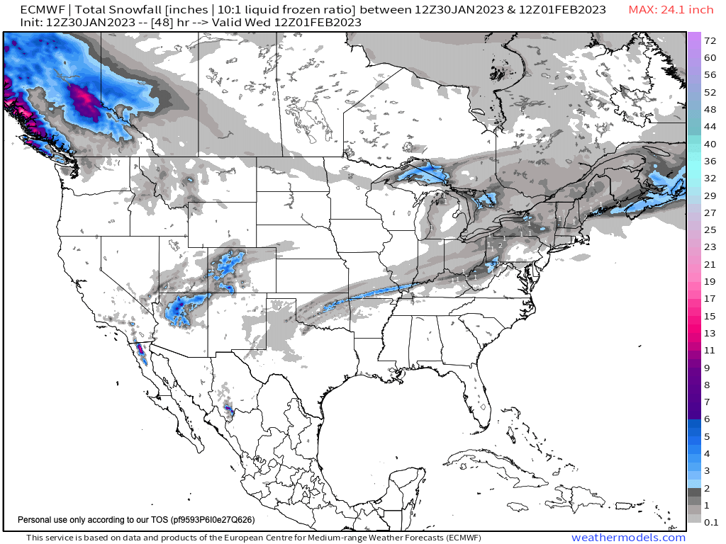
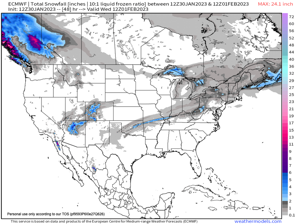
EPS not on-board wrt hour 156 snow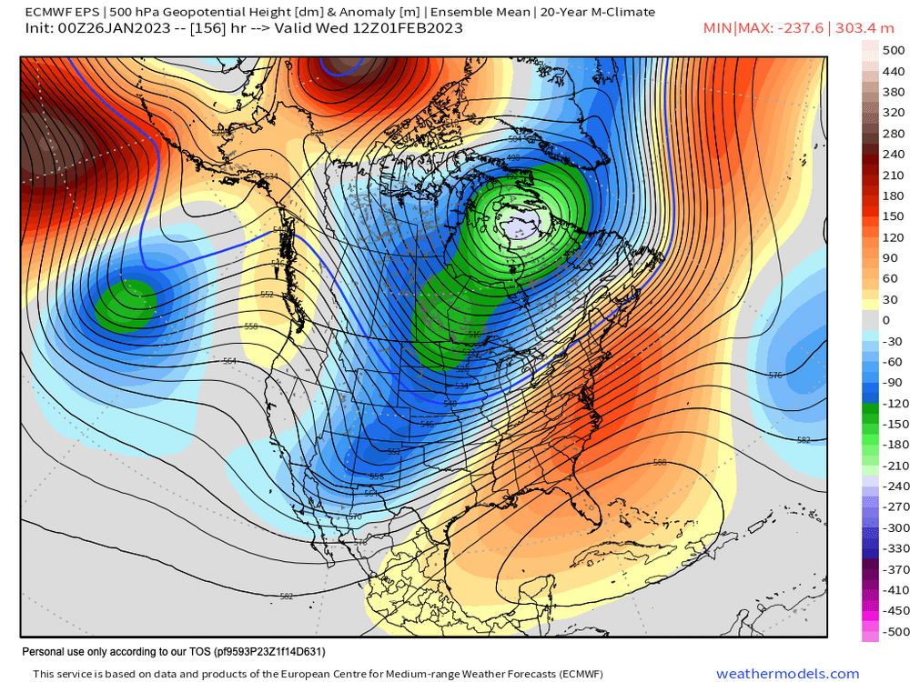
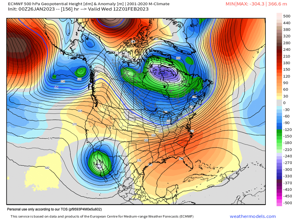
-
January/February Mid/Long Range Disco IV: A New Hope
dallen7908 replied to stormtracker's topic in Mid Atlantic
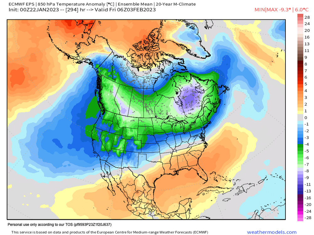
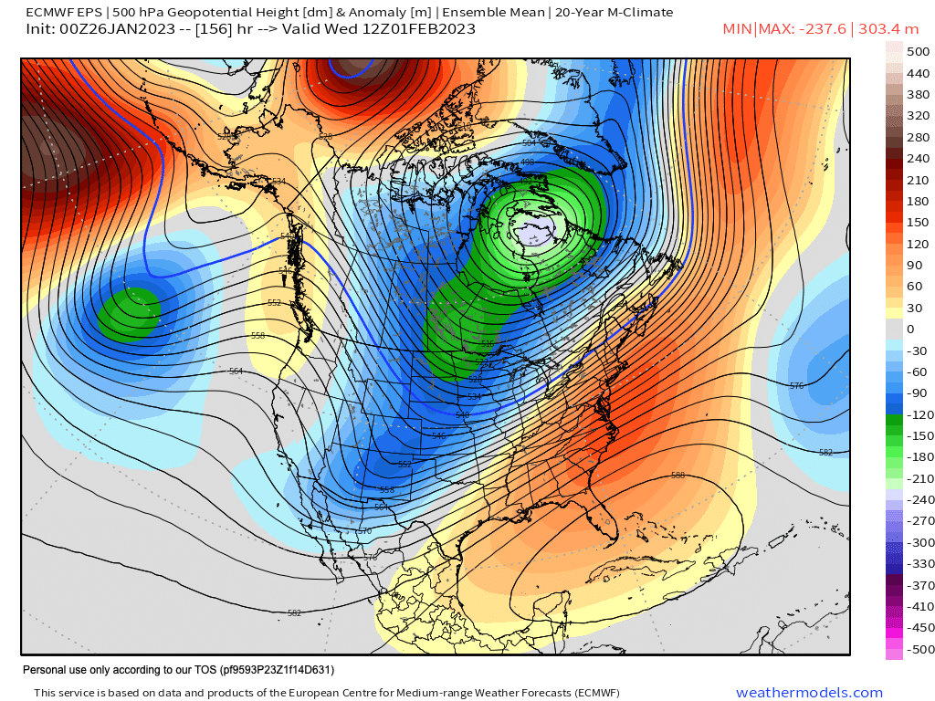
For illustration purposes only. Look at the split flow. Unfortunately, no interaction between the streams so we are left with surface lows associated with the southern and northern streams. ... and the cold air bottled up well to our north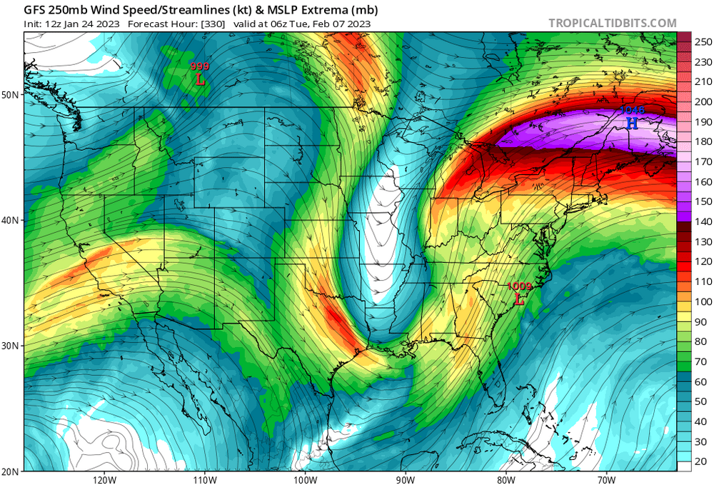
-
January/February Mid/Long Range Disco IV: A New Hope
dallen7908 replied to stormtracker's topic in Mid Atlantic